- Pan-Philippine Highway
-
Pan-Philippine Highway Maharlika Highway 
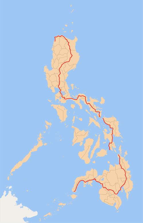
Route information Length: 3,517 km (2,185 mi) Major junctions North end: Laoag City, Ilocos Norte South end: Zamboanga City Highway system The Pan-Philippine Highway, also known as the Maharlika Highway (AH26) is a 3,517 km (2,185 mi) network of roads, bridges, and ferry services that connect the islands of Luzon, Samar, Leyte, and Mindanao in the Philippines, serving as the country's principal transport backbone.
The northern terminus of the highway is at Laoag City, and the southern terminus is at Zamboanga City.
Contents
Development
The highway was proposed in 1965, with government planners believing that it, in conjunction with other road construction, would stimulate agricultural production by reducing transportation costs, encourage social and economic development outside the major urban centers, and expand industrial production for domestic and foreign markets. It was and supported by loans and grants from foreign aid institutions, including the World Bank. When completed, it was considered a major achievement in road construction.
The highway was rehabilitated and improved in 1997 with assistance from the Japanese government, and dubbed the Philippine-Japan Friendship Highway.
In 1998, the Department of Tourism designated 35 sections of the highway as "Scenic Highways" with developed amenities for travelers and tourists.
Route
- Laoag City - Tuguegarao
- Cagayan Valley Road: Cagayan - Isabela - Nueva Vizcaya - Nueva Ecija - Bulacan
- Doña Remedios Trinidad Road: Baliuag - Pulilan
- MacArthur Highway: Guiguinto - Valenzuela - Caloocan
- Rizal Avenue: Caloocan - Manila
- Ronquillo and Bustos Streets: Plaza Carriedo
- Plaza Sta. Cruz
- Padre Burgos Avenue
- Taft Avenue: Manila - Pasay
- Redemptorist Road: Pasay - Parañaque
- Quirino Highway: Parañaque - Las Piñas
- Alabang-Zapote Road
- National Highway: Muntinlupa - Calamba
- Calamba - Batangas - Laguna - Quezon - Camarines Norte - Camarines Sur - Albay - Sorsogon
- Ferry from Matnog to Northern Samar
- Northern Samar - Samar - Leyte - Southern Leyte
- Ferry from Southern Leyte to Surigao del Norte
- Surigao del Norte - Surigao del Sur - Agusan del Sur - Compostela Valley - Davao del Norte - Davao City - Davao del Sur - South Cotabato - Sultan Kudarat - Maguindanao - Lanao del Sur - Lanao del Norte - Zamboanga del Sur - Zamboanga City
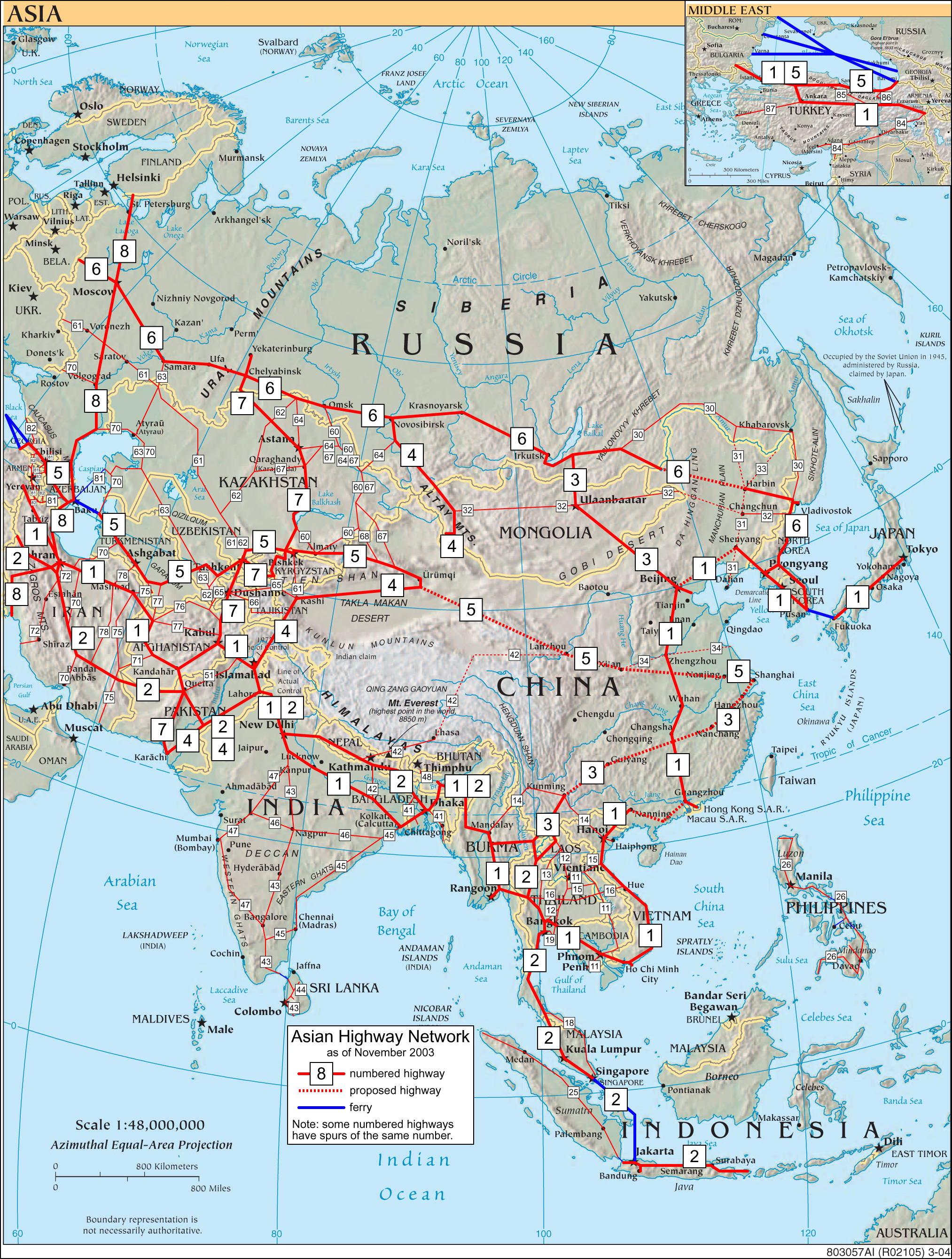
Asian Highway Network
The Pan-Philippine Highway is designated as AH26 in the Asian Highway Network, a cooperative project which seeks to improve highway systems and standards across the continent. It is currently the only highway in the network that does not connect to any other highway in the network — the sections of the Asian Highway Network in Japan (AH1), Sri Lanka (AH43) and Indonesia (AH2) are all linked to the mainland sections by ferries to South Korea (AH1), India (Dhanushkodi), and Singapore, respectively.
See also
- Transportation in the Philippines
- Department of Public Works and Highways (Philippines)
- Asian Highway Network
References
- http://www.bookrags.com/history/worldhistory/pan-philippine-highway-ema-04/
- http://manilarat.blogspot.com/2005/11/philippine-tourism-highway.html
- http://www.philippineembassy-usa.org/about/economy.htm
External links
Transportation in the Philippines Transportation agencies Public utility vehicles Bus companies AB Liner · ALPS The Bus, Inc. · Baliwag Transit · Bonifacio Transport Corp. · CEM Trans Services, Inc. · Ceres Liner · Citylink Coach Services Inc. · Dagupan Bus Co., Inc. · De Leon Express · Dela Rosa Transit · DLTBCo · Dominion Bus Lines · EMBC · Farinas Transit Company · Fermina Express · Five Star Bus Company · G Liner · Genesis Transport Service Inc. · Greenline Express · Green Star Express Inc. · GV Florida Transport · HM Transport Inc. · Inocencio Aniceto Transportation · JAC Liner Inc. · JAM · Joanna Jesh Transport Corp. · Juaymah Maureen Transport · King of Kings Transport · Lilian Express · Partas · Peñafrancia Tours and Travel Transport Inc. · Philippine Rabbit · Philtranco · Santrans · Saulog Transit Inc. · Vallacar Transit Corporation · Victory Liner · Viron TransitMajor highways A. Soriano Highway · Aguinaldo Highway · C-5 · Commonwealth Avenue · EDSA (C-4) · Governor's Drive · Halsema Highway · MacArthur Highway · Maharlika Highway · Manila-Cavite Expressway (Coastal Road) · Marikina-Antipolo Highway · NAIA Expressway · North Luzon (NLEx) · Quirino Highway · Sayre Highway · Subic-Clark-Tarlac (SCTEx) · Skyway · South Luzon (SLEx) · Southern Tagalog Arterial Road (STAR Tollway)Railways International airports Airlines Air Philippines · Cebu Pacific · Interisland Airlines · Pacific Pearl Airways · Philippine Airlines · PAL Express · Sky Pasada · South East Asian Airlines · Spirit of Manila · Tair Airways · Zest AirwaysWater transportation Shipping lines Cebu Ferries · Cokaliong Shipping Lines · Gothong Lines · Gothong Southern · Lite Shipping Corporation · Montenegro Lines · Negros Navigation · Roble Shipping Inc. · Sulpicio Lines · SuperFerry · Supercat Fast Ferry Corporation · Trans-Asia Shipping LinesCars of the Philippines Asian Highway Network AH1 · AH2 · AH3 · AH4 · AH5 · AH6 · AH7 · AH8 · AH11 · AH12 · AH13 · AH14 · AH15 · AH16 · AH18 · AH19 · AH25 · AH26 · AH30 · AH31 · AH32 · AH33 · AH34 · AH41 · AH42 · AH43 · AH44 · AH45 · AH46 · AH47 · AH48 · AH51 · AH60 · AH61 · AH62 · AH63 · AH64 · AH65 · AH66 · AH67 · AH68 · AH70 · AH71 · AH72 · AH75 · AH76 · AH77 · AH78 · AH81 · AH82 · AH83 · AH84 · AH85 · AH86 · AH87 · AH88 ·
 Categories:
- Roads in the Philippines
- Asian Highway Network
Wikimedia Foundation. 2010.