- Merritt Parkway
-
Merritt Parkway

Route information Length: 37.27 mi (59.98 km) Existed: 1938 – present Major junctions South end:  Hutchinson River Parkway in Rye Brook, NY
North end:  Route 15 (Wilbur Cross Parkway) in Milford, CT
Highway system The Merritt Parkway is a historic limited-access parkway in Fairfield County, Connecticut. The parkway is known for its scenic layout, its uniquely styled signage, and the architecturally elaborate overpasses along the route. It is designated as a National Scenic Byway and is also listed in the National Register of Historic Places.[1] Signed as part of Route 15, it runs from the New York state line in Greenwich, where it serves as the continuation of the Hutchinson River Parkway, to the Housatonic River in Stratford, where the Wilbur Cross Parkway begins. On May 19, 2010, the parkway was named one of America's Most Endangered Historic Places in 2010.[2]
Contents
Route description
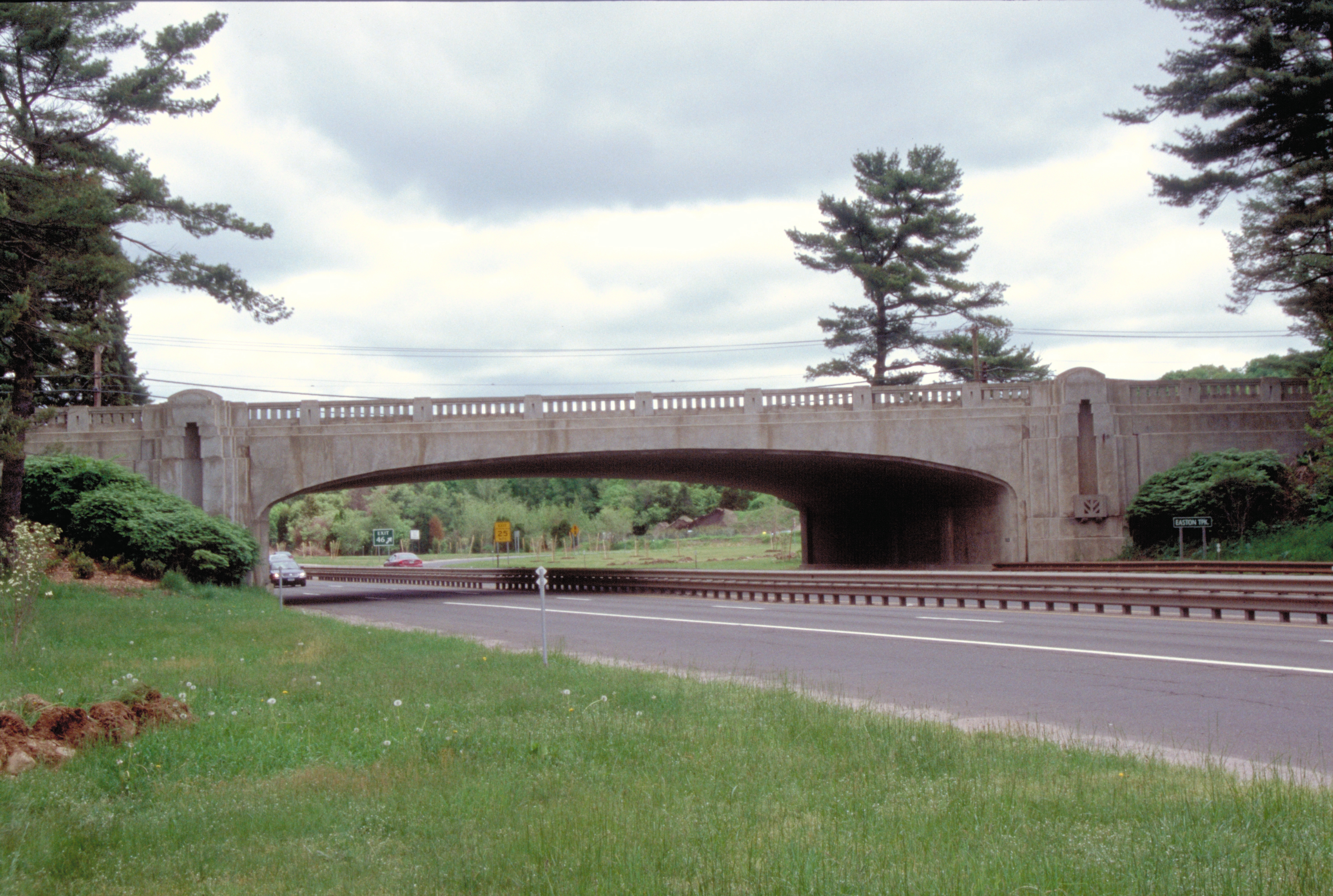
Merritt ParkwayLocation: Southwestern Connecticut Architect: Connecticut Highway Department; et al. Architectural style: Colonial Revival, Classical Revival, Modern Movement Governing body: Local NRHP Reference#: 91000410 Added to NRHP: April 17, 1991[3] The Parkway is one of a handful of United States highways listed in the National Register of Historic Places. It is acknowledged for the beauty of the forest that it passes through, as well as the architectural design of its overpasses; at the time of its construction, each bridge was decorated in a unique fashion so that no two bridges on the parkway looked alike. However, newer overpasses used by intersecting expressways did not maintain this tradition, and as a result the highway is now spanned by several ordinary modern bridges constructed using undecorated concrete on steel I-beams.

The Parkway has two lanes in each direction. Due to its age, it was originally constructed without the merge-lanes, long on-ramps, and long off-ramps that are found on modern limited-access highways. Some entrances have perilously short and/or sharp ramps; some entrances even have stop signs, with no merge lane whatsoever; this leads to some dangerous entrances onto the highway. Most have since been modernized, with the interchange of Route 111 in Trumbull featuring Connecticut's first single point urban interchange (SPUI). The speed limit on the parkway ranges from 45 to 55 mph (70 to 90 km/h). A section between Westport and Fairfield is a stretch, roughly five and a half miles long without a single exit, referred to by local traffic reports as "The No Exit Zone"[4] or "No Man's Land".[5]
Vehicles over 2.5 meters (eight feet) in height, weighing more than 3,650 kilograms (four tons), towing a trailer, or containing more than four wheels are not allowed on the parkway. (Under extenuating circumstances, however, ConnDOT may issue permits for oversize vehicles to use the Parkway.[6])
History
The Merritt Parkway is one of the oldest parkways in the United States. The portion from Greenwich to Norwalk was opened on June 29, 1938. The section from Norwalk to Trumbull was completed in November 1939 and in 1940 was finished to the Housatonic River in Stratford. The parkway was named for U.S. Congressman Schuyler Merritt, who was instrumental in enacting legislation allowing the parkway to be built. The Merritt Parkway is the first leg of what would later become the modern Route 15. Built between 1934 and 1940, the Merritt runs for 37 miles (60 km) from the New York state line in Greenwich to the Housatonic River in Stratford. It was conceived as a way to alleviate congestion on the Boston Post Road (U.S. Route 1) in Fairfield County. Six rest areas featuring parking lots, Mobil gas stations and convenience stores were also built so that drivers would not have to exit to refuel. These are located at either side of the parkway in Fairfield (exit 46), New Canaan (near exit 37) and Greenwich (CT-NY state line).
 Tree canopy over the Merritt, and grassy median
After the parkway fully opened in 1940, it was not uncommon for travelers to stop and picnic along the side of the road.[7] The Merritt Parkway Advisory Commission (later the Merritt Parkway Advisory Committee) decided upon banning horses and buggies, bicycles, pedestrians, billboards, and U-turns while a system of horse trails along the parkway were developed but were later abandoned.[8]
To ease objections from county residents who feared an influx of New Yorkers on their roads, in their towns, on their beaches and through their forests, highway planners called on engineers, landscape architects and architects to create a safe and aesthetically pleasing limited access highway - one with exit and entrance ramps, but no intersections - that would not spoil the countryside.
The bridges played a prominent role in the design. Architect George L. Dunkelberger designed them all. They reflected the popularity of the Art Deco style, with touches of neo-classical and modern design.[9][10][11] Some of these bridges were constructed by the Works Progress Administration.
 Toll booth 1955
Tolls were collected on the parkway at one toll plaza in Greenwich from June 21, 1939, until June 27, 1988. Two additional tolls were also located on the Wilbur Cross Parkway, in Milford and Wallingford. One of the parkway's former toll plazas is now preserved in Stratford's Boothe Memorial Park near Exit 53, complete with still-flashing lights over each toll lane.
In April 2001, a complete reissuance of the parkway's signs was carried out creating a uniform white-on-green and sawtooth border.
Safety of the parkway
In 2007, after complaints were voiced about the danger of the trees along the parkway, state officials announced they would trim and eliminate some of them more aggressively. A large, seemingly healthy tree fell on a car near Exit 42 in Westport in June 2007, killing a couple from Pelham, New York. A state study of fatalities on Connecticut highways showed that from 1985 to 1992, about ten people died every three years in tree-related accidents, although no other state roadway averaged more than one in three years. The state Department of Transportation commonly sends out work crews twice a year to drive along both sides of the parkway at 5 mph (8 km/h) in search of decrepit trees. Trees that had been scheduled to be cut down in five or ten years would be removed sooner. Some more trees also would be removed, as the shoulder of the parkway is being widened to eight feet in order to give drivers room to pull over.[12]
The state has a Merritt Parkway Advisory Committee that meets quarterly.[12]
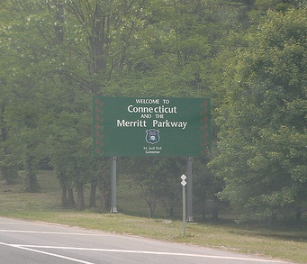
 Welcome sign in Greenwich
The Merritt Parkway in popular culture
- Jennifer Jones returned home by the State Police who found her walking on the Merritt Parkway after running out of gas in the 1956 film The Man in the Gray Flannel Suit starred Gregory Peck as Jones husband.
- Willem de Kooning painted a large oil canvas titled "Merritt Parkway" in 1959. It is owned by the Detroit Institute of Arts.
- Richard Shindell wrote an instrumental piece entitled "Merritt Parkway, 2 AM." The song can be found on his album, Somewhere Near Paterson, which was released in 2000.
- One of Denise Levertov's poems is about the parkway.
- The parkway is mentioned in the Titus Andronicus song "A More Perfect Union".
- "The Road Taken...The Merritt Parkway" 2008 documentary film by Lisa Seidenberg[13]
Exit list
Town Exit # Mile Destinations Notes Merritt Parkway ends at New York state line - Road continues as the Hutchinson River Parkway Greenwich 27 0.0  NY 120A (King St.) – Armonk
service station (both sides) Connecticut Information Center (northbound side only) 28 3.5 Round Hill Road To Greenwich business district 29 4.7 Lake Avenue 31 5.6 North Street To Greenwich business district Stamford 33 8.9 Den Road 34 9.5  Route 104 (Long Ridge Rd.) – Stamford
To downtown Stamford and University of Connecticut (Stamford campus). Northbound exit ramp redesigned and reopened in 2009. 35 10.7  Route 137 (High Ridge Rd.)
New Canaan 36 13.2  Route 106 (Old Stamford Rd.)
37 14.1  Route 124 – New Canaan, Darien
service station (both sides) Norwalk 38 15.9  Route 123 (New Canaan Ave.)
To Norwalk Community College. 39 17.3  US 7 – Norwalk, Danbury
Northbound exit only.
Split into 39A (Rt 7 Southbound) and 39B (Rt 7 Northbound).
Interchange redesign in proposal stage.[14] Preliminary construction work halted.40 17.6 Main Ave. Unsigned SR 719. Westport 41 20.6  Route 33 – Westport, Wilton
42 21.6  Route 57 – Westport, Weston
Fairfield 44 27.0  Route 58 – Fairfield, Redding
To Fairfield business district and Fairfield University. service station (both sides) 46 28.5  Route 59 – Fairfield, Easton
General Electric Headquarters Trumbull 47 29.2 Park Avenue To University of Bridgeport, Sacred Heart University. 48 30.6  Route 111 – Trumbull
Single Point Urban Interchange 49 32.2  Route 25 – Bridgeport, Danbury
Split northbound into 49N and 49S. Access to southbound Route 25 from northbound only. 50 32.8  Route 127 – Trumbull
Southbound exit and northbound entrance only. 51 33.7  Route 108 – Trumbull
Northbound exit and southbound entrance only. 52 34.1  Route 8 – Bridgeport, Shelton
Also signed southbound for Route 108. Stratford 53 36.9  Route 110 – Stratford, Shelton
Stratford/Milford line 37.5 Merritt Parkway ends - road continues as the Wilbur Cross Parkway
Igor I. Sikorsky Memorial Bridge (Housatonic River crossing)-

Map (west segment)
-

Map (east segment)
-

Talmadge Hill Metro-North station over the Parkway in New Canaan
See also
References
- ^ "Connecticut -- Fairfield County Historic Places". National Registry of Historic Places. http://www.nationalregisterofhistoricplaces.com/CT/Fairfield/districts.html. Retrieved 2007-08-24.
- ^ "America's 11 Most Endangered Historic Places". National Trust for Historic Preservation. http://www.preservationnation.org/travel-and-sites/sites/northeast-region/merritt-parkway.html. Retrieved 2010-05-23.
- ^ "National Register Information System". National Register of Historic Places. National Park Service. 2007-01-23. http://nrhp.focus.nps.gov/natreg/docs/All_Data.html.
- ^ "Traffic - A Guide to the Pure Chaos of the Merritt Parkway". DimeBrothers. http://www.dimebrothers.com/article.php?do=article&id=5. Retrieved 2008-02-18.
- ^ Radde, Bruce (1993). The Merritt Parkway. Yale University Press. pp. 84. ISBN 0300053797. http://books.google.com/?id=zJRcBMXmhmsC&pg=PA84&lpg=PA84&dq=%22merritt+parkway%22+%22no+man's+land%22. Retrieved 2008-02-18.
- ^ "What is allowed to travel on the Merritt Parkway?". Connecticut Department of Transportation. http://www.ct.gov/dot/cwp/view.asp?A=2137&Q=294976. Retrieved 2007-08-24.
- ^ Society, Trumbull Historical (2004-02-19). Trumbull. ISBN 9780738534589. http://books.google.com/?id=diB_6jR_gpIC&pg=PA82&lpg=PA82&dq=%22parking+and+sparking+banned+on+parkway%22#v=onepage&q=%22parking%20and%20sparking%20banned%20on%20parkway%22&f=false.
- ^ Radde, Bruce. The Merritt Parkway. Yale University Press, 1993 p83 ISBN 0300053797
- ^ "Local Legacies — The Merritt Parkway". The Library of Congress. http://lcweb2.loc.gov/diglib/legacies/CT/200002790.html.
- ^ Charles R. Roth. "The Merritt Parkway — The Queen of All Parkways". Trumbull, Connecticut Historical Society. http://www.trumbullhistory.org/merrittpkwy/. Retrieved 2007-10-04.
- ^ "A Scenic Roadway that Bridges many Divides". The Hartford Courant. http://www.courant.com/news/local/hc-asked0124.artjan24,0,5131371.story?coll=hc-utility-local. Retrieved 2007-01-24.
- ^ a b Ginocchio, Mark, "Merritt trees to face the ax," news article in The Advocate of Stamford, Connecticut, July 27, 2007, Norwalk edition, pp 1, A4
- ^ "The Road Taken…The Merritt Parkway". Westport Historical Society. October 6, 2008. http://www.westporthistory.org/press/the-road-taken-the-merritt-parkway/.
- ^ Koch, Robert (February 25, 2009). "DOT offers revised Route 7/Merritt interchange plan". The Hour (Norwalk). http://www.thehour.com/story/465609. Retrieved 2011-07-29.
- Radde, Bruce, "The Merritt Parkway", ISBN 0-300-06877-8. New Haven, Connecticut: Yale University Press 1993.
- "Traveling the Merritt Parkway", ISBN 0-7524-0946-8
- Historic American Engineering Record (Library of Congress)
External links
- Merritt Parkway Exhibit (Connecticut State Library)
- Merritt Parkway Conservancy
- Photos of the parkway at byways.org
- Photos of and information about the parkway at nycroads.com
- Connecticut Dept of Transportation rules about what vehicles are allowed on the parkway
- CT 15 (Greater New York Roads)
U.S. National Register of Historic Places Topics Lists by states Alabama • Alaska • Arizona • Arkansas • California • Colorado • Connecticut • Delaware • Florida • Georgia • Hawaii • Idaho • Illinois • Indiana • Iowa • Kansas • Kentucky • Louisiana • Maine • Maryland • Massachusetts • Michigan • Minnesota • Mississippi • Missouri • Montana • Nebraska • Nevada • New Hampshire • New Jersey • New Mexico • New York • North Carolina • North Dakota • Ohio • Oklahoma • Oregon • Pennsylvania • Rhode Island • South Carolina • South Dakota • Tennessee • Texas • Utah • Vermont • Virginia • Washington • West Virginia • Wisconsin • WyomingLists by territories Lists by associated states Other Categories:- National Scenic Byways
- Roads on the National Register of Historic Places in Connecticut
- State highways in Connecticut
- Transportation in Fairfield County, Connecticut
- Parkways in the United States
- Former toll roads in the United States
- Works Progress Administration in Connecticut


Wikimedia Foundation. 2010.