- WikiMapia
-
Not to be confused with Wikimaps or Wikimedia.
WikiMapia 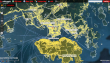
WikiMapia as seen in Firefox with fullscreen modeURL wikimapia.org Slogan Let's describe the whole world! Commercial? Yes Type of site Collaborative mapping Registration Optional Available language(s) 101 languages, including English Content license non-free[1] Creative Commons Attribution-NonCommercial-ShareAlike 3.0 Unported [2] Created by Alexandre Koriakine and Evgeniy Saveliev Launched May 24, 2006 Alexa rank  1,121 (November 2011[update])[3]
Revenue From AdSense Current status Active WikiMapia is a privately owned, online map and satellite imaging resource that combines Google Maps with a wiki system, allowing users to add information, in the form of a note, to any location on Earth.[4] Users may currently use this information for free.[5] Inspired by the success of Google Maps and Wikipedia, two Russian Internet entrepreneurs Alexandre Koriakine and Evgeniy Saveliev launched the website on May 24, 2006.[6] Its aim is to "describe the whole world". It now has over 15,000,000 places marked.[7] Although registration is not required to edit or add to WikiMapia, over 1,100,000 users[8] from around the world currently are registered.[9] All content uploaded by users becomes the intellectual property of WikiMapia and available under proprietary (non-free[10]) Creative Commons Attribution-NonCommercial-ShareAlike 3.0 Unported license through WikiMapia API.[11] Approximately 1,000 new users register everyday.
Contents
Features
WikiMapia allows any contributor to add a "tag" (placemark) to any location by marking out a polygon around the location and then providing a default language, title, description and one or more categories.[12] An optional note can be provided, as well as images and embedded YouTube videos, which all appear on the place's information window.[13] Multiple categories can be added to any placemark by clicking the add category link and either selecting from a list of common categories, or by typing in the first few letters of the word to search for a category. The numbers displayed in parentheses next to each category indicate the number of placemarks belonging to that category. Basic functions also allow users to link to a corresponding Wikipedia article, add an address, or specify whether a polygon outlines a building (as opposed to a parcel of land).
Pictures
Users also can add up to seven pictures to each tag by selecting Add/Manage Photos from the placetag's menu. This opens a dialog box, allowing the user to upload a photo from their computer or the Internet.
Languages
Location tagging is fully multi-lingual, meaning that there is no need to create separate tags for different languages. If a place is described in multiple languages, the user can navigate to other language pages by clicking on the link at the bottom of the window. Currently a total of 101 languages are supported, and 100% of the interface has been translated into 56 languages. Most of the languages (except Chinese) use ISO 639-1 naming conventions.[14] Registered users can help translate the WikiMapia interface at a special page.[15]
Linear features
WikiMapia also allows users to add "linear features", meaning roads, railroads, ferry lines, and rivers. The interface allows users to specify the size of the road (major highway, side street, dirt road, etc.), to indicate one-way streets, and to provide a brief description. It also allows users to describe intersections and tunnels. The railroad and ferry line interfaces are similar to the one used for roads. The river-marking tool is somewhat more complex, as there are secondary lines that can be used to define the river's shoreline. The roads feature is also used to populate a drop-down list of nearby street names in a tag's address box. As of February 2011, WikiMapia collectively contains over 6,000,000 km of roads, over 2,500,000 km of rivers, over 1,300,000 km of railways and over 450,000 km of ferry routes.
WikiMapia API
In December 2009 WikiMapia launched an API for non-commercial use.[16]
Watchlists
WikiMapia also allows registered users to set up watchlists to monitor changes on certain areas of the map. Users can define the size and location of each watched region and save it under a unique name.
WikiMapia forum
In addition to the Messaging system, which runs from the map screen, WikiMapia also operates a forum, which was launched in October 2007.[17] Although a separate wiki user guide exists, most of WikiMapia's policy discussions take place at the forum.
User accounts and levels
Optional user accounts were introduced in October 2006.[18] User levels and permissions have evolved over time in response to the need to control vandalism or abuse. As explained in the WikiMapia FAQ, there are three user-levels.
- User Level 0 (UL0): Level 0 is the default user level assigned to all new users. UL0 are able to add places, edit existing places, and use the personal messaging system. New users are temporarily prevented from posting in the forum.
- User Level 1 (UL1): Users are automatically upgraded to UL1 after a few days. In addition to the regular UL0 functions, UL1 users are able to change polygons (place outlines), add roads, add rivers, add railroads, delete places, and contribute to the forum. The vast majority of WikiMapia contributors fall into this category.
- Advanced User (Formerly UL2): A few hundred registered WikiMapia users have been granted advanced access. Advanced User permissions include functions which are vital to maintaining site security (such as the ability to initiate ban proceedings on vandals) and anti-vandalism efforts on the map itself (such as the ability to delete a greater number of tags, to protect tags against editing by unregistered users, and to quick-delete certain tags).
Advanced User status
Advanced User status may be one of the most misunderstood aspects of WikiMapia's hierarchy, in part, because the process of promotion remains mysterious to most new users.[19] Advanced User permissions are granted solely at the discretion of WikiMapia Administrators (or site owners), and have been revoked in a few instances. Although WikiMapia Administrators have historically taken recommendations by senior users into account when promoting new users,[20] they have also occasionally acted unilaterally to demote Advanced users.
Clutter and filtering
In some areas of the world with out-of-date or very expensive mapping, such as in the case of developing countries, WikiMapia growth has been phenomenally rapid. This rapid growth brought problems of its own, however. Urban areas became covered with thousands of overlapping rectangles marking the positions of private residences, but there was no provision in the WikiMapia interface for distinguishing those residences from places of public interest.
Licensing
December 2010 WikiMapia announced[21] that all the content is now available under Creative Commons licence 3.0(by-nc-sa) through the API. Because the WikiMapia's geo-located data is all built based on aerial imagery from Google Maps, the dataset (and any further derivations from it) may attract copyright as a "derived work". This will depend on jurisdiction, and generally is an unclear area of copyright law, but the principle allows aerial photography companies to license (at great expense) the right to derive geo-data from their imagery. Although Google have not been known to sue for copyright violation in the courts over use of aerial imagery, their terms of service do include provisions regarding their rights over derived data. The approach taken by WikiMapia is in contrast with a more clean-room "from scratch" re-mapping approach as followed by the OpenStreetMap project.
Business model
The site generates some income using Google ads.
Interoperability
Limited WikiMapia functionality is available on:
- Google Earth, using Google Earth dynamic layer in KML file.[22]
- Any HTML webpage, using code for a map frame which can be found on the top menu, under "WikiMapia:Map on your page"
- Most Java-enabled cellphones using 3rd party software such as Mobile GMaps.
- iPhone application.[23]
See also
- Bhuvan
- Collaborative mapping
- Google Earth
- Google Map Maker
- List of GPS Software for Mobile Phones
- List of wikis
- OpenStreetMap
- Participatory GIS
- Placeopedia
- Public Participation GIS
References
- ^ http://freedomdefined.org/Licenses/NC
- ^ Wikimapia.org
- ^ "Wikimapia.org Site Info". Alexa Internet. http://www.alexa.com/siteinfo/wikimapia.org. Retrieved 2011-11-02.
- ^ Bear, David (2007-01-07). "Getting a bird's-eye view of any place on Earth". Pittsburgh Post-Gazette. http://www.post-gazette.com/pg/07007/751307-96.stm. Retrieved 2007-11-13.
- ^ "Wikimapia Terms of Service". http://wikimapia.org/terms_reference.html. Retrieved 2010-12-10.
- ^ Mount, Nick; Paul Aplin, and Gary Priestnall (2008). Representing, Modeling, and Visualizing the Natural Environment. CRC Press. p. 271. ISBN 1420055496. http://books.google.com/books?id=_copvxkM3n8C&pg=PA271&dq=Alexandre+Koriakine#v=onepage&q=Alexandre%20Koriakine&f=false.
- ^ "Wikimapia Main Page". http://wikimapia.org. Retrieved 2010-01-24. (See bottom right corner)
- ^ Wikimapia.org
- ^ "Wikimapia user statistics page". http://www.wikimapia.org/sys/user_stats/?order=rating&sort=desc. Retrieved 2010-12-10.
- ^ http://freedomdefined.org/Licenses/NC
- ^ "Wikimapia Terms of Service". 2010-12-10. http://wikimapia.org/terms_reference.html. Retrieved 2010-12-10.
- ^ Koriakine, Alexandre (2006-12-04). "Place types, etc.". http://wikimapiablog.blogspot.com/2007/01/place-types-etc.html. Retrieved 2007-11-14.
- ^ Jones, Matt (2007-01-11). "How To #5: YouTube in Wikimapia!". http://wikimapia.mattjonesblog.com/2006/12/04/how-to-5-youtube-in-wikimapia/. Retrieved 2007-11-14.
- ^ "Wikimapia forum: ISO letters". wikimapia.org. http://wikimapia.org/forum/?t=2823&goto=55070#goto55070. Retrieved 2009-05-12.
- ^ Translate
- ^ WikiMapia blog
- ^ "WikiMapia FAQ". 2006-10-08. http://www.wikimapia.org/faq.htm. Retrieved 2007-11-14.
- ^ Koriakine, Alexandre (2006-10-08). "Registration started". http://wikimapiablog.blogspot.com/2006/10/registration-started.html. Retrieved 2007-11-14.
- ^ "Forum Topic: Pitr". http://wikimapia.org/forum/?t=1957&goto=34231. Retrieved 2009-07-18.
- ^ "Wikimapia forum: Good users". http://wikimapia.org/forum/?t=754&goto=7269. Retrieved 2009-07-18.
- ^ "Wikimapia Blog: Wikimapia content is now available under Creative Commons License". http://blog.wikimapia.org/node/33. Retrieved 2010-12-10.
- ^ Wikimapia.org
- ^ Mifki.com
External links
- Official website
- Official WikiMapia Blog
- WikiMapia Terms of Reference
- WikiMapia Forum for discussions
- WikiMapia API
- WikiMapia Full User Guide
- Wikimapia Wiki
- WikiMapia UserScript add-on for FireFox, Opera and Google Chrome
- Matt Jones' WikiMapia Blog
- Meta.Wikimedia/about the connection with Wikipedia
- 'Borderless' - WikiMapia Anthem
- Приложение для iPad - WikiMapia
- Как использовать в GPS Garmin векторные объекты WikiMapia
Earth-related topics History Geography
and geologyEcology - Earth Day
- Gaia philosophy
- Global warming
- Human impact on the environment
- Millennium Ecosystem Assessment
Imaging - Bhuvan
- Bing Maps
- Google Earth
- Google Maps
- NASA World Wind
- OpenStreetMap
- Ovi Maps
- Remote sensing
- WikiMapia
- Yahoo! Maps
Arts, culture
and society- Earth in culture
- Earth in fiction
- Etymology of the word "Earth"
- Flat Earth and Hollow Earth
- History of the world
- International law
- Landscape art
- List of countries
- World economy
Spirituality
and teleology- Creation myth
- Creationism
- Earth Mother
- Gaia (Ancient Greece)
- New Age Gaian
- Planetary Logos (Theosophy)
- Tellus Mater (Ancient Rome)
- Earth sciences portal
- Solar System portal
Categories:- Geographic information systems
- Web Map Services
- Web mapping
- Collaborative mapping
- Web 2.0
- Wikis
- Wiki communities
- Keyhole Markup Language
- Internet properties established in 2006
- Maps

Wikimedia Foundation. 2010.