Prince of Wales Island (Queensland)

Prince of Wales Island (Queensland)
Prince of Wales Island
Native name: Muralag

Muralug on map
Prince of Wales Island (Queensland) is located in Australia
{{{alt}}}
Prince of Wales Island (Queensland) (Australia)
Geography
Location Torres Strait
Coordinates 10°40′55″S 142°11′19″E / 10.68194°S 142.18861°E / -10.68194; 142.18861
Archipelago Torres Strait Islands
Major islands Prince of Wales Island, Thursday Island
Area 204.6 km2 (79 sq mi)
Length 19.5 km (12.12 mi)
Width 18.6 km (11.56 mi)
Highest elevation 247 m (810 ft)
Highest point Mount Scott
Country
Australia
State  Queensland
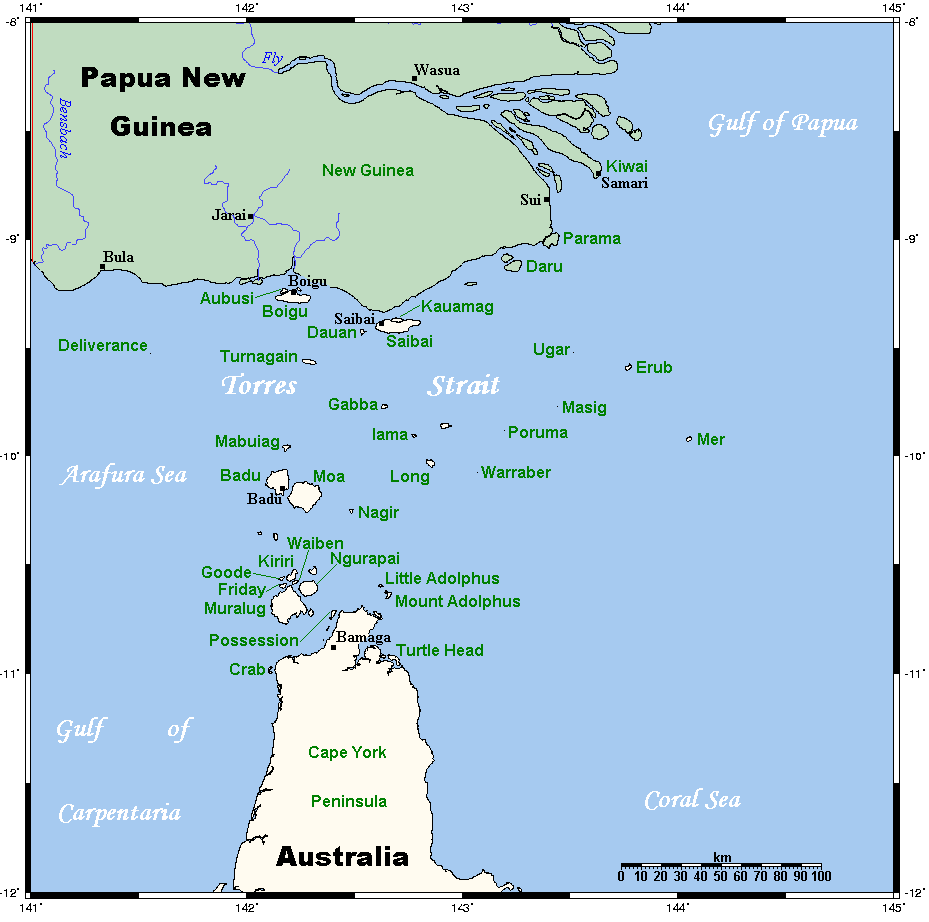
Shire Shire of Torres
Island Region Inner Islands
Largest city Muralug (pop. 20)
Demographics
Population 20 (as of 2001)
Density 0.1 /km2 (0.3 /sq mi)
Ethnic groups Torres Strait Islanders
Additional information
largest island of the Torres Strait Islands

Prince of Wales Island (Muralug Island) is an island 20 km (12 mi) north of Muttee Heads which is adjacent to Bamaga at the tip of Cape York Peninsula within the Endeavour Strait Queensland, Australia in the Torres Strait and south of Thursday Island.

With an area of 204.6 km2 (79 sq mi), Prince of Wales Island is the largest of the Torres Strait Islands. Being inhabited only by a few Kaurareg families (population 20 in 2001), it is very sparsely populated. The village in the north is called Muralug, after the native name of the island. The northeastern corner of the island, Kiwain Point, is only 830 m (908 yd) away from Vivien Point of Thursday Island, the main and most populous of the Torres Strait Islands, separated by Normanby Sound.

Muralag or Muralug Island, also known as Prince of Wales, comes under the jurisdiction of Torres Shire Council. However most of the land has been returned to the Kaurareg People, who are the traditional owners of the island.

Contents

See also

Aerial photos & maps

References


External links


Wikimedia Foundation. 2010.

Игры ⚽ Поможем написать курсовую

Look at other dictionaries:

  • Prince of Wales Island — may refer to:*Prince of Wales Island (Alaska), USA *Prince of Wales Island (Nunavut), Canada *Prince of Wales Island (Queensland) is one of the Torres Strait Islands in Queensland, Australia *The former name of Penang Island, Malaysia …   Wikipedia

  • Prince-of-Wales-Insel (Queensland) — Vorlage:Infobox Insel/Wartung/Höhe fehlt Prince of Wales Insel Landsat Bild der Prince of Wales Insel …   Deutsch Wikipedia

  • Prince of Wales Island — Prince of Wales Insel (bzw. Prinz von Wales Insel oder engl. Prince of Wales Island) ist die Bezeichnung mehrerer Inseln: Prince of Wales Insel in Alaska, siehe Prince of Wales Insel (Alaska) Prince of Wales Insel im Kanadisch Arktischen Archipel …   Deutsch Wikipedia

  • Prince of Wales Island — 1. the largest island in the Alexander Archipelago, in SE Alaska. 1500 sq. mi. (3990 sq. km). 2. an island in N Canada, in the Northwest Territories. ab. 14,000 sq. mi. (36,000 sq. km). * * * ▪ island, Nunavut, Canada       island in the Canadian …   Universalium

  • Prince-of-Wales-Insel — (bzw. Prinz von Wales Insel oder engl. Prince of Wales Island) ist die Bezeichnung mehrerer Inseln: Prince of Wales Insel in Alaska, siehe Prince of Wales Insel (Alaska) Prince of Wales Insel im Kanadisch Arktischen Archipel, siehe Prince of… …   Deutsch Wikipedia

  • Yeta (Port Lihou Island), Queensland — Yeta, or Port Lihou Island is an island in the Torres Strait, in Queensland s north between the Australian mainland and Papua New Guinea. It is located at coord|10|44|S|142|14|E|region:AU QLD type:isle.Yeta is a small island that lies off the… …   Wikipedia

  • Moa Island, Queensland — Moa Island (Banks Island) is an island 90 km north of Thursday Island Queensland, Australia in the Banks Channel Torres Strait.This island is one of the Torres Strait Islands and is the largest of all Torres Strait islands and has 2 settlements… …   Wikipedia

  • Albany Island (Queensland) — w1 Albany Island Lage der Torres Strait Inseln Gewässer Pazifischer Ozean Inselgruppe …   Deutsch Wikipedia

  • Horn Island, Queensland — Horn Island Queensland View of Horn Island from Thursday Island …   Wikipedia

  • Booby Island (Queensland) — Booby Island is an island West of Muttee Heads at the tip of Cape York Peninsula within the Endeavour Strait Queensland, Australia. This island in the Torres Strait, south of Thursday Island and Prince of Wales Island.hipwrecksIn the 19th century …   Wikipedia

Share the article and excerpts

Direct link
Do a right-click on the link above
and select “Copy Link”