- Syrmia
-
"Srem" redirects here. For other meanings of "Srem" and "Srem", see Srem (disambiguation).
 Map of the Syrmia region
 Coat of arms of Srem, Serbia
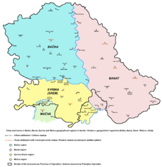
Syrmia (Serbian: Срем, Srem; Croatian: Srijem; German: Syrmien; Hungarian: Szerémség) is a fertile region of the Pannonian Plain in Europe, between the Danube and Sava rivers. It is divided between Serbia in the east and Croatia in the west.
Most of Syrmia is located in the Srem and South Bačka districts of Serbia's Autonomous Province of Vojvodina. Smaller part of the region around Novi Beograd, Zemun, and Surčin belongs to the City of Belgrade. The westernmost part lies in eastern Croatia, in Vukovar-Srijem County.
Contents
Name
Today, the name Srem/Срем is used in Serbian to designate the region, whereas the name Srijem is used in Croatian.
Other names for the region include:
- Latin: Syrmia or Sirmium
- German: Syrmien
- Hungarian: Szerémség or Szerém
- Slovak: Sriem
- Rusyn: Срим
- Turkish: Sirem
- Ukrainian: Срем, also Срім or Срим
- French: Syrmie
- Italian: Sirmia
History
 Map of Indo-European Vučedol culture centered in Syrmia (3000-2400 BC)
Throughout its history, Syrmia has been a part of the Roman Empire, the Hun Empire, the Ostrogothic Kingdom, the Gepid Kingdom, the Lombard state, the Byzantine Empire, the Avar Khaganate, the Frankish Empire, the Bulgarian Empire, Pannonian Croatia, the Kingdom of Hungary, the Ottoman Empire, the Habsburg Monarchy, the Austrian Empire, Austria-Hungary, the State of Slovenes, Croats and Serbs, the Kingdom of Serbia, the Kingdom of Serbs, Croats and Slovenes, the Kingdom of Yugoslavia, and the Socialist Federal Republic of Yugoslavia which, upon advice from the Ðilas Commission, assigned the eastern part of the region to the Federated Republic of Serbia and the western part to the Federated Republic of Croatia in 1945. After the recognition of Croatian independence in January 1992 and the creation of the Federal Republic of Yugoslavia in April 1992, the division became an international border. In 2003, the Federal Republic of Yugoslavia was transformed into the state union of Serbia and Montenegro, which was abolished in 2006, making the eastern part of Syrmia part of an independent Republic of Serbia.
Between 3000 BC and 2400 BC, Syrmia was a core area of Indo-European Vučedol culture.[1][2]
The name Syrmia derives from the name of the ancient city of Sirmium, today Sremska Mitrovica. Sirmium was originally an Celtic or Illyrian town founded in 3rd century BC and conquered by Romans in the 1st century BC. Opposing Roman rule, Illyrian tribes from the region started an uprising in AD 6 lead by Baton and Pines.
Sirmium was an important city in the Roman Empire. It was the economic capital of Roman Pannonia and one of four capital cities of the Empire. Ten Roman Emperors were born in this city or in its surroundings: Herennius Etruscus (227-251), Hostilian (230?-251), Decius Traian (249-251), Claudius II (268-270), Quintillus (270), Aurelian (270-275), Probus (276-282), Maximianus Herculius (285-310), Constantius II (337-361) and Gratian (367-383). These emperors were mostly Romanised Illyrians by origin. The Roman province Pannonia Secunda, which included Syrmia and parts of present day Slavonia and Bosnia was administered from Sirmium.
In the 6th century, Pannonia, a province of the Byzantine Empire existed in Syrmia. In the 7th century, the ruler of Syrmia was Kuber, a Bulgar leader, who ruled over the region as Avar vassal. In the beginning of the 9th century, Syrmia was for the short time part of Slavic state of Savia-Pannonia, ruled by Prince Ljudevit Posavski, since the local Slavs joined his rebellion. After the Franks defeated his rebellion, they secured the vassalage of the Slavs in the region (a mixture of Serbs, Croats, Abordrites). The Bulgarians conquered it from the Franks in 827 after a diplomatic dispute over the territory - they saw the territory as rightfully theirs since prior to Ljudevit's rebellion, the Slavs of the region were Bulgar clients. After a peace treaty in 845 AD, the Bulgarians still controlled Syrmia. The mountain Fruška Gora ("Frankish monuntain" in Serbo-Croatian) got its name after the old Serbo-Croatian name for Frankish people - Fruzi (Frug=Frank, Fruzi=Franks, fruški=Frankish).
In the 11th century, the ruler of Syrmia was duke Sermon, vassal of Bulgarian emperor Samuil. Sermon produced his own golden coins in present day Sremska Mitrovica. After Bulgarians were defeated by Byzantine Empire, Sermon was captured and killed by Constantine Diogenes because he refused to comply with new authorities.
After the defeat of Sermon, the area was included into the Byzantine Empire, although the extent and duration of actual Byzantine control over the area is unclear. The short-lived Thema of Sirmium was established, including both the region of Syrmia and the present-day region of Mačva, thus the name of Syrmia became designation for the both territories. The region was captured by the Kingdom of Hungary in the 12th century. "Pope Gregory IX confirmed that "[Margaretha] soror…regis Ungarie" acquired "terram…ulterior Sirmia" by bull dated 3 Mar 1229"[3] It is recorded that in 1231, a duke of Syrmia was Giletus. During the 13th century, the territory of Syrmia was divided into two counties: Syrmia in the east and Vukovar in the west.
Between 1282 and 1316 the Serb King Stefan Dragutin ruled a Serbian kingdom, colloquially called Syrmian Kingdom, which was created from parts of medieval Kingdom of Rascia, Mačva, Usora, Soli and east Syrmia.[4][5][unreliable source?] His capital cities were Debrc (between Belgrade and Šabac) and Belgrade. Before that time he was King of Rascia. In that time the name "Syrmia" was designation for two territories: Upper Syrmia (present day Syrmia) and Lower Syrmia (present day Mačva). In Ilok in western Syrmia was the seat of a Hungarian nobleman by the name of Ugrin Csák until his death in 1311.
At first, Stefan Dragutin was a vassal of the Hungarian king, but since the central power in the Kingdom of Hungary collapsed, both, Stefan Dragutin and Ugrin Csák were de facto independent rulers. Stefan Dragutin died in 1316, and was succeeded by his son, King Stefan Vladislav II (1316–1325), while Ugrin Csák died in 1311. Stefan Vladislav II was defeated by the king of Rascia, Stefan Uroš III Dečanski, in 1324, and after this, Lower Syrmia became a subject of dispute between the Kingdom of Rascia and the Kingdom of Hungary. The Upper Syrmia was, after 1311, included into the possession of the Hungarian king, while its western part (the Vukovar county) was later included into Banate of Slavonia.
-

Ancient Indo-European peoples in Syrmia
-

Ancient Roman cities in Syrmia
-

Territory ruled by Sermon, a duke of Syrmia, 11th century
-

Realms of Stefan Dragutin and Ugrin Csák, 14th century
In 1404 Hungarian King Sigismund lend parts Syrmia to Serbian Despot Stefan Lazarević for governing, later succeeded by Đurađ Branković.[6] After the Ottoman Empire conquered Serbian Despotate in 1459, the Hungarian kings renewed the legacy of Serbian Despots to the House of Branković in exile, later to the Berislavić family, who continued to govern most of Syrmia until the Ottoman conquest. The despots were vassals of Hungarian king and their residence was Kupinik (modern Kupinovo). The Despots were: Vuk Grgurević (1471–1485), Đorđe Branković (1486–1496), Jovan Branković (1496–1502), Ivaniš Berislavić (1504–1514), and Stjepan Berislavić (1520–1535). The last of the titular Serbian despots in Syrmia, Stevan Berislav, moved in 1522 to Slavonia, since Kupinik was seized by the Ottoman forces. Another important local governor has been Laurence of Ilok, a Duke of Syrmia (1477–1524), who reigned over large parts of the region from Ilok.
Parts of the region were captured by the Ottomans in 1521, and by 1538, the entire region was included into the Ottoman Empire. Between 1527 and 1530, a duke of Syrmia was Radoslav Čelnik, who ruled over this region as Ottoman vassal. During the Ottoman rule, an administrative unit known as the Sanjak of Syrmia existed in this region.
The Habsburg Monarchy took Syrmia from Ottomans between 1699 and 1718, and incorporated entire region into its Military Frontier. The County of Syrmia was established in Syrmia in 1745 as part of the Kingdom of Slavonia, a Habsburg land, mainly inhabited by Serbs and Croats. According to 1790 data, population of the Kingdom of Slavonia was composed of: Serbs (46.8%), Croats (45.7%), Hungarians (6.8%), and Germans (0.7%). The southern parts of Syrmia remained part of the Military Frontier.
-

Duchy of Syrmia of Radoslav Čelnik in 1527-1530
-

Ottoman Sanjak of Syrmia in 1568-1571
-

Habsburg-Ottoman frontier in Syrmia in 1699
In 1807, a large rebellion of the Syrmian peasants known as the Tican's Rebellion started in the estate of Ruma and the estate of Ilok with center in the village of Voganj. In 1848 and 1849, most of Syrmia was part of the Serbian Voivodship, a Serb autonomous region within the Austrian Empire, while between 1849 and 1860, its northern part (municipalities of Ilok and Ruma) was part of the Voivodship of Serbia and Tamiš Banat, a separate Austrian crown land.
After 1860 the County of Syrmia was established again, and it was again incorporated into the Kingdom of Slavonia, which was a separate Austrian crown land in that time. The Kingdom of Slavonia was incorporated into the Kingdom of Hungary in 1868, and it became part of Croatia-Slavonia, an autonomous region within the Kingdom of Hungary (one of two parts of Austria-Hungary).
 Coat of arms of Syrmia county of Croatia-Slavonia (Kingdom of Hungary, Austria-Hungary)
On October 29, 1918, Syrmia became a part of the newly independent State of Slovenes, Croats and Serbs, while on November 24, the Assembly of Syrmia proclaimed the unification of Serb-populated parts of Syrmia with the Kingdom of Serbia. From December 1, 1918, entire Syrmia was a part of the Kingdom of Serbs, Croats and Slovenes.
The region was first a county of the Kingdom of Serbs, Croats and Slovenes between 1918 and 1922, then a province (oblast) of the Kingdom between 1922 and 1929. In 1929, after a new territorial division, the region was divided between Danube Banovina and Drina Banovina, which were provinces of the Kingdom of Yugoslavia, and in 1931 it was divided between Danube Banovina and Sava Banovina. In 1939, the western part of Syrmia was included into the newly formed Banovina of Croatia.
In 1941 Syrmia was occupied by the World War II Axis powers and its entire territory was attached to the Independent State of Croatia. In 1945 there had been created new borders in this area between federal states of Democratic Federal Yugoslavia and, since then, Eastern Syrmia (formerly part of Danube Banovina), together with Bačka and Banat, has been part of the Serbian Autonomous Province of Vojvodina, while Western Syrmia (formerly part of Sava Banovina) has been part of Croatia.
When Croatia declared its independence in 1991, Serbs who lived in the Croatian part of Syrmia proclaimed their autonomous region over portions of western Syrmia. The region was known as the Serbian Autonomous Region of Eastern Slavonia, Baranja and Western Syrmia. This region was one of the two Serbian autonomous regions that formed the Republic of Serbian Krajina in 1991. The creation of Krajina was triggered by the fact that the new Croatian government changed the constitutional status of Serbs in Croatia from nation to national minority.[citation needed] Although change was made by more than 2/3 majority, and there was given guarantees for civil rights for every Croatian citizen, from the point of view of the Serbs this revoking of their nation status was illegal, thus the creation of Krajina (internationally unrecognized entity) was seen by them as legal way to protect their rights. After in 1995 Croatian forces regained control over western part of Krajina, the eastern part was turned over to the UNTAES, and was peacefully reintegrated into Croatia by January 1998 (These events were part of war in Croatia).
-

Proclaimed borders of the Serbian Voivodship in 1848, including most of Syrmia.
-

The County of Syrmia within Croatia-Slavonia in 1881.
-

Liberated partisan territory in Syrmia in the end of 1942
-

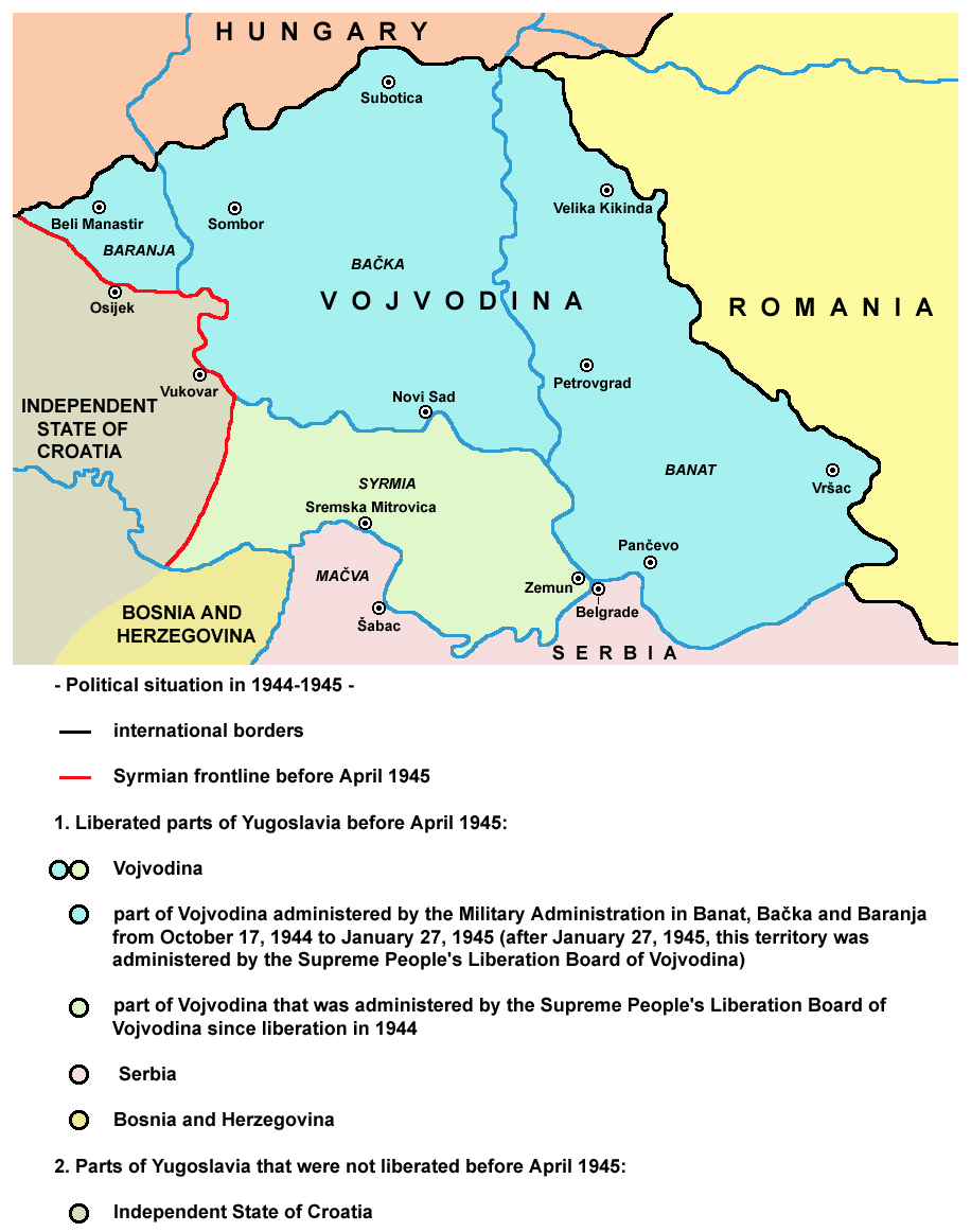
Syrmian frontline before April 1945
Demographics
Main article: Demographic history of Syrmia Serb soldier in Syrmia in 1742
According to the 2002 census in Serbia, the population of the Serbian part of Syrmia (in geographical borders) numbering 790,697 people and is composed of:[7]
According to the 2001 census in Croatia, the population of the Croatian Vukovar-Srijem county, numbering 204,768, is composed of:[8]
- 160,277 Croats (78.27%)
- 31,644 Serbs (15.45%)
- 2,047 Hungarians (1%)
- 1,796 Rusyns (0.88%)
- 1,338 Slovaks (0.65%)
Geography
Borders
 Srem District in Vojvodina.
 Vukovar-Srijem county within Croatia.
The present international border was drawn in 1945 by the Đilas commission, as the divide between the Yugoslav constituent republic of Croatia and the Autonomous Province of Vojvodina, itself part of Serbia, within Yugoslavia. Milovan Đilas, a Montenegrin and then a confidante of Josip Broz Tito, drew the border according to demographic criteria, which explains why the Croatian town of Ilok on the Danube, with a Croat majority, lies east of Šid in Serbia, with a Serb majority. Nonetheless, the border drawn in 1945 was very similar to internal Kingdom of Yugoslavia border of 1931-1939 between the Danube Banovina and the Sava Banovina.
There are two particularly isolated chunks of territory along the border - one is the Croatian territory of Ilok, which is mostly surrounded by Serbian territory from land, while the other is the Serbian territory of Jamena, which is mostly surrounded by Croatian territory from land.
Bordering regions
- Bačka to the north, across Danube
- Banat to the east, also across Danube
- Šumadija the south-east, across Sava
- Mačva to the south, across Sava
- Semberija to the south-west, across Sava
- Slavonia to the west. The border between Syrmia and Slavonia is unclear. According to one interpretation, it runs roughly along a line through Vukovar, Vinkovci, and Županja. According to another interpretation, the border follows the Bosut, Barica and Vuka rivers.
Cities
 Map showing cities and towns in Serbian part of Syrmia.
List of cities in Syrmia (with population figures):
- Serbia
- Belgrade city region
- Novi Beograd (217,180)
- Zemun (146,172)
- Surčin (14,209)
- Dobanovci (8,114)
- Vojvodina
- Sremska Mitrovica (39,041)
- Ruma (32,125)
- Inđija (26,244)
- Stara Pazova (18,628)
- Šid (16,301)
- Petrovaradin (13,917)
- Sremska Kamenica (11,140)
- Sremski Karlovci (8,839)
- Beočin (8,037)
- Irig (4,854)
- Belgrade city region
- Croatia
Petrovaradin, Sremska Kamenica, Sremski Karlovci and Beočin are geographically located in Syrmia, but they are part of South Bačka District.
Municipalities
Municipalities in the Serbian part of Syrmia:
- Šid
- Sremska Mitrovica
- Irig
- Ruma
- Inđija
- Stara Pazova
- Pećinci
- Novi Beograd
- Zemun
- Surčin
- Sremski Karlovci
- Petrovaradin
- Beočin
Note: Syrmian villages of Neštin and Vizić are part of the municipality of Bačka Palanka (main part of this municipality is not located in Syrmia but in Bačka), while several settlements that are part of the municipality of Sremska Mitrovica are not located in Syrmia but in Mačva.
Municipalities and villages in the Croatian part of Syrmia:
- Vukovar
- Ilok
- Vinkovci
- Županja
- Otok
- Trpinja
- Borovo
- Tordinci
- Markušica
- Jarmina
- Ivankovo
- Vođinci
- Stari Mikanovci
- Babina Greda
- Cerna
- Gradište
- Andrijaševci
- Privlaka
- Bošnjaci
- Drenovci
- Gunja
- Vrbanja
- Nijemci
- Tovarnik
- Lovas
- Tompojevci
- Stari Jankovci
- Negoslavci
- Bogdanovci
- Nuštar
Mountains
The region's principal mountain is Fruška Gora with its highest peak of Crveni Čot at 539 m.
See also
- Srem District
- Vukovar-Srijem County
- Syrmia County
- Sanjak of Syrmia
- Kingdom of Srem
- Theme of Sirmium
- Sirmium
- Vojvodina
- Slavonia
- Serbian Orthodox Eparchy of Srem
- Roman Catholic Diocese of Srijem
References
- ^ http://www.vjesnik.hr/html/2001/04/01/Clanak.asp?r=kul&c=1
- ^ http://files.myopera.com/edwardpiercy/blog/Area-Culture-Map-1.JPG
- ^ "Margit of Hungary", on Charles Cawley's "Medlands" project
- ^ R. Veselinović, Istorija Srpske pravoslavne crkve sa narodnom istorijom I, Beograd 1969., page 18
- ^ R. Grujić, Pravoslavna Srpska crkva, Kragujevac 1989., page 22
- ^ Sve o Slankamenu
- ^ Popis stanovništva, domaćinstava i stanova 2002. Knjiga 1: Nacionalna ili etnička pripadnost po naseljima. Srbija, Republički zavod za statistiku Beograd 2003. ISBN 86-84443-00-09
- ^ http://www.dzs.hr/Hrv/Popis%202001/popis20001.htm
Geographical regions of Serbia Bačka • Banat • Belica • Binačko Pomoravlje • Braničevo • Dobrič • Drenica • Goljak • Gora • Gornje Livade • Gornji Breg • Gruža • Has • Homolje • Ibarski Kolašin • Jadar • Jasenica • Kačer • Kolubara • Komarani • Kosanica • Kosmaj • Kosovo • Kučaj • Lepenica • Lešnica • Levač • Lugomir • Lužnica • Mačva • Malo Kosovo • Metohija • Mlava • Moravac • Negotinska Krajina • Opolje • Pančevački Rit • Pčinja • Pešter • Pocerina • Podgor • Podlužje • Podrinje • Podunavlje • Polimlje • Pomoravlje • Pomorišje • Posavina • Potisje • Preševo Valley • Rasina • Raška • Rugovo • Sandžak • Srem • Stari Vlah • Stig • Svrljig • Šajkaška • Šopluk • Šumadija • Tamnava • Telečka • Timočka Krajina • Toplica • Veliki Rit • Vlasina • Zaglavak • Zlatibor • Župa
Geographical regions of Croatia Banija • Baranja • Bukovica • Central Croatia • Dalmatia • Gorski kotar • Istria • Kninska Krajina • Konavle • Kordun • Krbava • Lika • Međimurje • Moslavina • Podravina • Podunavlje • Poljica • Posavina • Ravni Kotari • Slavonia • Spačva • Srijem • Šokadija • Zagora • Zagorje


Wikimedia Foundation. 2010.