- Indiana Dunes National Lakeshore
-
Indiana Dunes National Lakeshore IUCN Category V (Protected Landscape/Seascape)

Location Porter / Lake / LaPorte counties, Indiana, United States Nearest city Gary, Indiana Coordinates 41°38′53″N 87°06′29″W / 41.64806°N 87.10806°WCoordinates: 41°38′53″N 87°06′29″W / 41.64806°N 87.10806°W Area 15,067 acres (60.97 km2) Established November 5, 1966 Visitors 2,127,336 (in 2005) Governing body National Park Service  West side of the national lakeshore
 East side of the national lakeshore
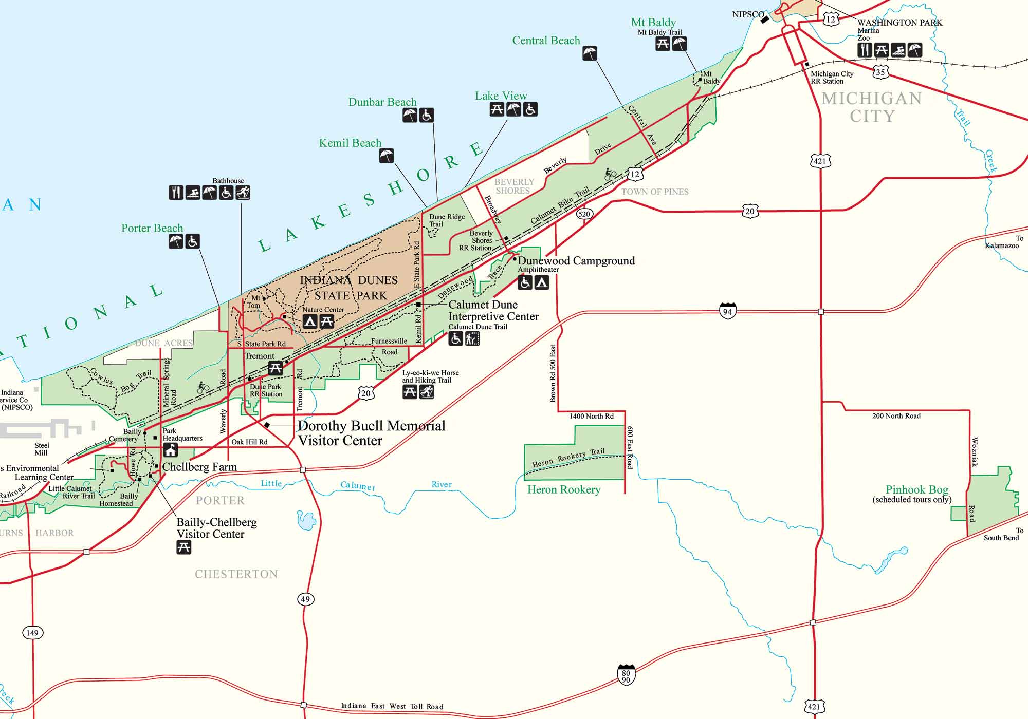
Indiana Dunes National Lakeshore is a U.S. National Lakeshore located in northwest Indiana and managed by the National Park Service. It was authorized by Congress in 1966. The national lakeshore runs for nearly 25 miles (40 km) along the southern shore of Lake Michigan, from Gary, Indiana, on the west to Michigan City, Indiana on the east. The park contains approximately 15,000 acres (6,100 ha).
The National Lakeshore has development rights over the area within its boundaries, but has not purchased the full extent of the property. Its holdings are non-contiguous and do not include the Indiana Dunes State Park (1916), a separate, 2,182-acre (883 ha) parcel of protected dune land on the lakefront near Porter, Indiana.
The park is physically divided into an eastern area and a western area. The eastern area is roughly the lakeshore south to U.S. 12 or U.S. 20 between Michigan City, Indiana on the east and the Mittal Steel Plant on the west. A small extension, south of the steel mill continues west along Salt Creek to Indiana 249. The western area is roughly the shoreline south to U.S. 12 between the US Steel Plant at Burns Harbor west to Broadway, downtown Gary, Indiana. In addition, there are several outlying areas, including; Pinhook Bog, in LaPorte County to the east. The Heron Rookery in Porter County, the center of the park, and the Calumet Prairie State Nature Preserve and Hobart Prairie Grove, both in Lake County, the western end of the park. A related area is the Hoosier Prairie State Nature Preserve, managed by the Indiana Department of Natural Resources.
History
Main article: History of the Indiana DunesHuman presences in the Indiana ground and there is little evidence of permanent communities forming during the earlier years. Archeological evidence is consistent with seasonal hunting camps. The earliest evidence for permanent camps is consistent with the Hopwellian occupation of the Ohio valley. Five groups of mounds have been documented in the dunes area. These mounds would be consistent with the period of 200 BC (Goodall Focus) to 800 BC (early Mississippian).[1] Even that was a short lived permanency. The advent of European exploration and trade, introduced more changes to the human environment. Tribal animosities and traditional European competition affected tribal relations. Entire populations began moving westward, while others sought to dominate large geographic trading areas. Once again the dunes became a middle point on a journey from the east or the west. It continued to remain a key hunting ground for villages over a wide area.
See also: Petit fortIt wasn't until the 19th century that native villages once again were scattered through the area, but this was soon followed by European settlement. Joseph Bailly was the earliest recorded settler in the dunes. He moved here from trading villages around Niles, Michigan. Settling along the Calumet River.[2] Soon he was joined by a series of other settlers and the communities in the dunes began to develop. They included Chesterton, Porter, Tremont, and the Town of the Pines. These pioneer communities grew and expanded. Today, the entire coast line has been settled for use as homes, factories, businesses and some reserved for public parks.
See also: List of Nike missile locations, Nike (rocket), and U.S. Route 12 in IndianaPreserving the dunes
 Mather visits the Indiana Dunes
A movement began in 1899 to preserve the unique area of the dunes. In 1916, the visionary National Parks Director Stephen Mather held hearings in Chicago on a "Sand Dunes National Park".[3] In 1926, the Indiana Dunes State Park opened. In the 1950s, a desire to maximize economic development through a "Port of Indiana" spurred interest in preservation. Save the Dunes Council President Dorothy Buell began a nationwide campaign to buy the land. Their first success was the purchase of 56 acres (230,000 m2) in Porter County, the Cowles Tamarack Bog.[3] The Kennedy Compromise entailed the creation of a national lakeshore and a port. Then Illinois Senator Paul H. Douglas lead the Congressional effort to save the dunes. In late 1966, the bill passed and the Indiana Dunes National Lakeshore became a reality. Four subsequent expansion bills for the park (1976, 1980, 1986, and 1992) have increased the size of the park to more than 15,000 acres (61 km2).[3]
See also: Marquette Park (Gary) and Indiana Dunes State ParkSee also: Chronology of the Indiana Dunes and Bailly Nuclear Power PlantGeology of the Lakeshore
Main article: Geology of the Indiana Dunes Glacial Lake Chicago, 14,000 years before present
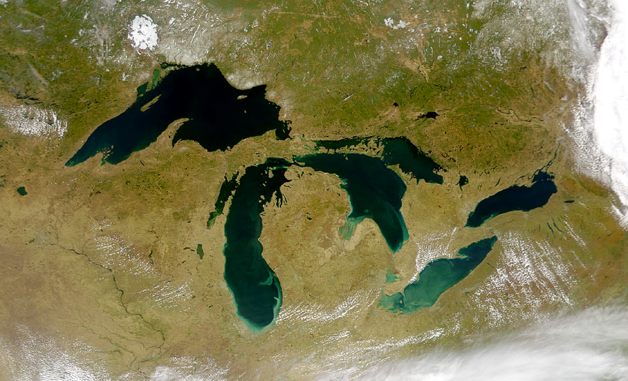
The Lake Michigan Basin was formed during the Wisconsin Glacial Period. The Michigan Lobe of the continental glacier began its retreat northward over 20,000 years before present (YBP)[4] forming the southern shore of the Lake Michigan Basin.
The Valparaiso Moraine is the dominant geologic form that created the various landscape forms of the Indiana Dunes, about 40,000 YBP.[4] Within the arc created by the Valparaiso Moraine are two younger recessional moraines of the Tinley Moraine and the Lake Border Moraine. Each moraine created an artificial dam across the southern outflow of the melt waters of the receding glaciers. As each glacial lake breached a low spot in the moraines, water levels receded, leaving a series of shorelines and dune ridges.[4]
The Calumet Shoreline is the oldest visible shoreline of Lake Michigan. It is a visible a sand ridge along Ridge Road through Lake and Porter Counties, Indiana. Two older shorelines, the Tolleston and the Glenwood Shoreline are much harder to identify and further south in the counties.[5]
During the periods of glacial retreat, there were periods of stability. During these times, glacial lakes formed along the southern borders of the glaciers, bound into the Lake Michigan Basin by the recessional moraines. Four major glacial lake periods created the Indiana Dunes. They are the glacial Lake Chicago (14,000 YBP), Glacial Lake Algonquin (9,000 YBP), glacial Lake Chippewa (7,000 YBP), and Lake Nipissing stage (4,000 YBP). Once the glaciers had fully retreated from the Lake Michigan basin, post Lake Nipissing stage, the same factors that created the dunes south of the current shoreline, expanded the existing shoreline.[4] The littoral currents or Longshore drift transport sand southward along the eastern shore of Lake Michigan. As they encounter streams bringing water from inland, sandbars are created, pointing down current, either southward if the shore is north to south or westward along the southern shore itself.[5] If the currents are strong enough as they were when the Glenwood Shoreline was created, shallow inland bays would be formed with a wide sand spit between it and the open lake.[5] Over time, the sand spits would merge with the far shoreline forming interdunal ponds.[5] Each sand spit would be come a dune ridge. As the ponds filled in and wind built the outer sand ridges higher, the ponds would dry up and only a stream would remain, as the Little Calumet River does today, just south the state and national parks. As the shoreline moved northward, new ridges formed, additional streams, now slower and less powerful formed and the process duplicated itself. To the west of the Indiana Dunes, Wolf Lake in Hammond, Indiana forms a western border to the dunes. Here the same process is at work, only the littoral drift is again south, but along the western shore, pushing the sand and sand spits eastward.[5] Today, it is the remants of the marsh lands and inter-dunal or inter-sand spit lakes that have formed this region over 40,000 years.[5]
Flora and fauna
The park is in the Central forest-grasslands transition ecoregion.
BioBlitz 2009: Indiana Dunes was the third of ten National Park Units to participate in a National Geographic Society and National Park Service BioBlitz. For twenty-four hours beginning at noon May 15, citizen scientist (volunteers) and scientists explored the national lakeshore, attempting to document all the life forms along the shoreline. This joint project began in 2007 at Rock Creek and Potomac Parkway in Washington, D.C. In 2008, it moved to the west coast and Santa Monica Mountains National Recreation Area spent twenty-four hours documenting thousands of species. The program is a joint effort by the National Park Service and the National Geographic Society in collaboration with local environmental groups: Dunes Learning Center, Chicago Wilderness, Great Lakes Research and Education Center, Indiana Department of Natural Resources, Sea Grant of Illinois-Indiana, and the United States Geological Survey.[6]
Rare, Threatened, and Endangered Species
The park includes habitats for several rare plants and animals. None of the plants are on the Federal list of Threatened and Endangered Species (T&E Species), but several are on the list of State T&E Species.[7] Populations of each plant group are estimated to be around 100-120 individual plants. The species included are:[7]- White baneberry, (Actaea pachypoda)
- Virginia snake root (Aristolochia serpentaria)
- Shooting Star (Dodecatheon media)
- American columbo (Frasera caroliniensis)
- Pink corydalis (Corydalis sempervirens)
Among the rare and endangered wildlife are:[7]
- Indiana bat, (Myotis sodalis)
- eastern massasauga rattlesnake, (Sistrurus catenatus catenatus)
In addition, the park has habitat suitable for:[7]
- bald eagle, (Haliaeetus leucocephalus)
Species Count
The numbers below are taken from the Main Articles or See also articles attached to this page. They will be updated as additional list/articles are created.Group Number of Species Extirpated Species See Also Chordates or Animals with Backbones Mammals or Mammalia 4111[8]Mammals of the Indiana Dunes Birds or Aves 352[9]2Birds of the Indiana Dunes Reptiles or Reptilia 23[9]List of reptiles of the Indiana Dunes Amphibians or Amphibia 18List of Amphibians of the Indiana Dunes Fish 71[9]List of fish of the Indiana Dunes Invertebrate or Animals without Backbones Arthropoda (Crustacea)-Crustacean 15List of crustaceans of the Indiana Dunes Arthropoda (Chelicerata)-Arachnida 12List of Arachnids of the Indiana Dunes Arthropoda (Chelicerata)-Insects 296Insects of the Indiana Dunes and Ants of the Indiana Dunes Arthropoda (Myriapoda)- other Invertebrates 2Invertebrates of Indiana Dunes Annelida-segmented worms Mollusca 66List of non-marine mollusks of the Indiana Dunes Plants or Plantae Vascular plant–ferns.[10] 26All samples were confirmed in the Indiana Dunes State Park Vascular plant-clubmosses Vascular plant-flowering plants 1,130[11]Flowering Plants of the Indiana Dunes Vascular plant-conifers Fungi 64Bryophytes - Bryophyta (mosses), Marchantiophyta (liverworts), and Anthocerotophyta (hornworts). 41Algae - especially the green algae. Lichens algae and fungi in a symbiotic arrangement[12] 6292Change in the number of species between 1896 (Calkins) and 1986 (Wetmore)[12] Invasive Plants 54List of invasive plant species in the Indiana Dunes Plankton and other microscopic life forms Plankton[13] 33Total to date 2,336105
Wildlife - Indiana Dunes National Lakeshore is full of wildlife, including white-tailed deer, Red Fox, raccoons, opossums, cottontail rabbits, Canada geese, seagulls, squirrels, hawks, Turkey Vultures, mallards, Great Blue Herons, garter snakes, songbirds, and rodents.Flowering Plants - The Indiana Dunes has over 369 species of flowering plants. Of these, thirteen are considered Threatened or Endanger of extinction. Additionally, there four invasive flowering plants on the list. Some of the most common spring flowers include the May Apple, buttercups (6 varieties), and violets (14 varieties). Summer brings out the orchids (5 varieties) and lots of goldenrod (11 varieties).[14]
See also: Pitcher's thistleInvasive Plants - Invasive plants are those introduced species that dominate a landscape pushing out traditionally native species and others species by their ability to multiply rapidly. There are 54 such species in the dunes.[15]
Unusual Sightings
In October 1920, a rare Arctic Three-toed Woodpecker was captured a mile west of Dune Park Station. Later that month another male was captured east of Dune Park Station. One was busy digging out grubs and the other was nervously flying from tree to tree.[16]In May 1919, a Clay-colored Sparrow was found near Dune Park. It was a part of a larger flock of Harris's Sparrow migrating along the western shore of Lake Michigan.[16]
Extirpated Species
Several species of plants and animals have disappeared from the dunes. Few can be clearly identified. Among those species thought to be gone are listed below:Species Latin Name Last Seen[8] Eastern Cougar[17] F.c. Cougaur[8] 1830American Bison Bos Bison[8] 1731Elk Wapiti (Cervus elephus)[8] 1830Lynx Lynx lynx[8] 1880Bobcat Lynx rufus[8] 1880Gray Wolf Canius Lupus[8] 1908Red Wolf Canus Rufus[8] 1832Black Bear Ursus Americanus[8] 1850Fisher (animal) Martes Pennanti[8] 1855River Otter Lutra canadenais[8] 1900Porcupine Erethizon dorsatum[8] 1918Passenger Pigeon Ectopistes migratorius 1900Piping Plover Charadrius melodus Exotic and Invasive Species
Main article: List of invasive plant species in the Indiana DunesAlien or exotic species are plants and animals which are not native to the area. These plants can be classified as Invasive if they rapidly replace other plants and animals in the ecosystem, creating a monoculture and threatening the extinction of the tradiational plants and animals. Among plants found in the park, the following are considered to be exotic. Those marked with an '*' are listed as invasive
- Yarrow, (Achillea millefolium)
- Tree of heaven, (Ailanthus altissima)*
- Garlic mustard, (Alliaria petiolata)*
- Japanese barberry, (Berberis thunbergii)*
- Oriental bittersweet, (Celastrus orbiculatus)*
- Ox-eye daisy, (Chrysanthemum leucanthemum pinnatifidum)
- Field thistle, (Cirsium arvense)*
- Common day-flower, (Commelina communis)
- Queen Anne's lace, (Daucus carota)
- Autumn olive, (Eleaegnus umbellate)*
- Creeping Charlie, (Glechoma hederacea)*
- Yellow downy bush honeysuckle, (Lonicera x muendeniensis)
- Bush honeysuckle, (Lonicera tartarica)*
- English plantain, (Plantago lanceolata)
- Japanese knotweed, (polygonum cuspidatum)*
- Sulphur cinquefoil, (Potentilla recta)
- All-heal, (Prunella spp.)
- Apple, (Pyrus malus)
- Black locust, (Robinia pseudoacacia)*
Natural areas
Main article: Habitats of the Indiana DunesSee also: Oak savanna- Calumet Prairie
 Calumet Prairie
Calumet Prairie is a joint venture between the National Park Service and the Indiana Department of Natural Resources. The Calumet Prairie State Nature Preserve in the northern portion of the land between Interstate 90 to the north and the Little Calumet River on the south. The National Lakeshore owns the southern half of this plot.
- Cowles Bog
Main article: Cowles BogCowles Bog, a National Natural Landmark, is a fen wetland named in honor of biologist and ecologist Henry Chandler Cowles. Located south and west of Dune Acres, Indiana, Cowles Bog is the sole remaining remnant of the "Central Dunes" where Cowles performed his pioneering field studies of Ecological succession and species diversity. A National Lakeshore trail runs from Mineral Springs Road into Cowles Bog.[18]
- Great Marsh
See also: MarshThe Great Marsh is an interdunal wetland just south of the dune ridge overlooking Lake Michigan. It stretches from steel plants in Burns Harbor, 12 miles (19 km) east to County Line Road on the edge of Michigan City. A century ago, it was the nesting and migratory layover for many birds, which depended on its variety of plants.[19] In the late 19th century, the marsh was drained through a series of ditches, creating three watersheds and reducing the water table. As the water levels changed, new plants and trees moved in, creating a new habitat and displacing the wildlife that was dependent on the pre-existing wetlands.[19]
- Native Plants & Animals
- Coots
- Mallards
- Wood Ducks
- Kingfishers
- Tree Swallows
- Rusty Blackbirds
- Green Herons
- Beaver
- sedges
- Invasive Plants
- Restoration
Beginning in 1998, the national lakeshore began restoration of the marsh by closing Derby Ditch and restoring 500 acres (200 ha). The work consist of:[19]
-
- Plugging culverts
- Filling ditches
- Creating levees with spillways
- Planting native plants, either as seed or small sprouts
- Removing non-native plants and trees
Heron Rookery
See also: Heron Rookery Yellow Trout-Lily
The Heron Rookery is located along the East Arm Little Calumet River in the northeast corner of Porter County. The Rookery is physically separated from the main part of the park. It is accessible from County Road 600 East, south of County Road 1400 North. The rookery is a hardwood forest. In the spring, the Great Blue Herons can be seen nesting in the dead snags north of the river. Spring also brings out a variety of wildflowers.[20]
- Hoosier Prairie
Main article: Hoosier PrairieHoosier Prairie, a National Natural Landmark, is a 430 acre (1.7 km2) tallgrass prairie adjacent to Griffith, Indiana. It is a geographically isolated unit of the Lakeshore, owned and maintained by the Indiana Department of Natural Resources as a state nature preserve. Some 574 species of plants have been observed growing in this patch of prairie.
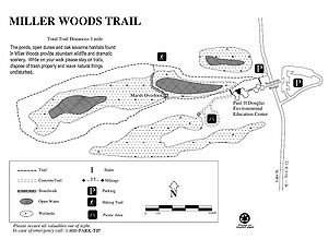
- Miller Woods[21]
Miller Woods is located in Miller Beach, Indiana It is accessed through the Douglas Center for Environmental Education on Lake Street. The area is dominated by dune and swale topography. the ridges or swells are beach and dune sand. They date from the post Glacial lake Nipissing period some 3000 years before present. The swales are the depressions between the ridges. They are generally either ponds or marshes.
- Mnoke Prairie
Mnoke Prairie is an active prairie restoration along Beam Street in the Town of Porter.
Mount Baldy
 Typical wildflowers near Mount Baldy. Plants such as these help hold the dune together.
Mount Baldy is a sand dune located west of Michigan City, Indiana. At 123 feet (37 m) tall, it is one of the tallest sand dunes on the southern shore of Lake Michigan. It is a wandering dune that moves an average of 4 feet (1.2 m) every year, and so is called a "living dune." Mount Baldy is accessible from U.S. Route 12 (also known as Dunes Highway) between the Town of Pines and the western border of Michigan City. Visitors can hike 0.7 miles (1.1 km) up the dune and from the top, on a clear day, can view Chicago's skyline and the south shore. North of Mount Baldy is a swimming beach. As of early 2007 the dune hike to the summit is closed due to erosion of the dune, however a new trail through the forest will still take hikers to the summit.
- Pinhook Bog
Main article: Pinhook BogPinhook Bog, a National Natural Landmark, is a geographically isolated unit of the National Lakeshore. The quaking peat bog is located near U.S. Route 421 approximately 9 miles (14 km) south of Michigan City. The bog formed from a postglacial kettle moraine left behind about 14,000 years before the present by the melting of the ice sheet during the end of the Last glacial period. The acidic bog is noted for pitcher plants and other wetland species. Access to the bog is restricted to ranger-led guided tours.[22]
Historic areas
Bailly-Chellberg Farms
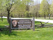
The Bailly-Chellberg farmstead is located close to the geographic center of the National Lakeshore, at U.S. Route 20 and Mineral Springs Road.
Bailly Homestead
Main article: Joseph Bailly HomesteadThis is the location of the pioneer trading post established in 1822 by fur trade pioneer Joseph Bailly. Bailly settled here and his last home, adapted from his 1830s retirement house, survives.[23] The Homestead was designated a U.S. National Historic Landmark in 1962.
Chellburg Farm
Main article: Chellberg FarmThe real estate became the home of the Chellberg family, who built a farm on its sandy soil. As of 2008[update], the Lakeshore maintains a heritage farm on the Chellberg land, with the Bailly family cemetery on the northern edge of the property.[24]
Bailly Cemetery
Main article: Bailly Cemetery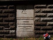
The Bailly Cemetery is located half a mile north of the homestead. Its location is a sandy bluff, which once looked out across the dunes to Lake Michigan.[25] Today, the forest covers the dunes and the lake is no visible. Numerous changes have occurred since the first burial in 1827.[26]
Joseph Bailly buried his only son by Marie in the fall of 1827 on a sandy knoll. He erected an oak cross on the site and a three-sided shelter. After 1866, the Bailly area was no longer the quiet place that it had been. Other families now lived in the area and some had been using the cemetery for their families. Late in 1866, Rose Howe (granddaughter of Joseph Bailly) had the family plots fenced and requested that other remove their family to other cemeteries. In 1879, she had the entire cemetery walled in and an iron gate installed to the north.[26]
Finally in 1914, Rose Howe took one further step to protect the cemetery of her family. She had the area inside the wall filled with sand. Stone steps replaced the gate to a contemplative walk atop the cemetery. An oaken cross was raised atop this new ground, continuing the tradition started by her grandfather. Rose Howe died in 1916, while in California. She was returned to Indiana in 1917 and was the last burial in the family cemetery.[27]
Century of Progress Architectural District
Main article: Century of Progress Architectural District The Florida Tropical House, back elevation taken from the beach.
The Century of Progress Architectural District is listed on the National Register of Historic Places and is located in Beverly Shores, Indiana. The district consists of a total of five buildings, all from the Homes of Tomorrow Exhibition during the 1933 Century of Progress World's Fair which took place in Chicago.[28]
Good Fellow Club Youth Camp
Created by the Good Fellow Club of U.S. Steel in 1941, the camp served the children of Gary, Indiana until 1977. It provided outdoor recreation and a chance to leave the city behind for a week or more.[29] The camp used tent cabins with a central restroom and shower house. Top a rise was the main lodge where meals were provided and a trading post with a bowling alley were maintained.Lustron Homes
See also: Lustron house Lustron House on Drake Ave
The national lakeshore acquired three Lustron homes during its land acquisition process. The Jacob Klien House was located in an endangered habitat. It was moved to the east side of Drake Avenue in Beverly Shores and placed atop a dunes overlooking the lake. The Schulof house located on Lakefront Drive was transferred to the Historic Landmarks Foundation of Indiana for preservation and it was moved to Stephens Street in Porter, Indiana. The Powell house remains inaccessible within the park on Lakefront Drive.[30]
Swedish Farmsteads Historic District (pending)
Main article: Swedish Farmsteads of Porter County, IndianaThe Swedish Farmsteads of Porter County, Indiana are representative of the numerous rural communities settled by a significant ethnic population. They influenced the religious community and social community. Swedish immigration was at its highest from 1840 until 1920. At its height, 1910, it was estimated that 1 out of every 5 Swedes was living in the United States.[31]
Recreational Opportunities & Activities
 Richard Lieber (front right) with NPS Director Stephen Mather at what would become Indiana Dunes State Park in 1916.
The park contains 15 miles (24 km) of beaches, as well as sand dunes, bogs, marshes, swamps, fens, prairies, rivers, oak savannas, and woodland forests. The park is also noted for its singing sands. More than 350 species of birds have been observed in the park. It has one of the most diverse plant communities of any unit in the U.S. National Park System with 1418 vascular plant species including 90 threatened or endangered ones. The Indiana Dunes area is unique in that it contains both Arctic and boreal plants (such as the bearberry) alongside desert plants (such as the prickly pear cactus).
First-time visitors to the Lakeshore often go to the Dorothy Buell Memorial Visitor Center at U.S. Route 20 and Indiana Route 49, near Porter, Indiana. This brand-new center (2007) offers standard visitor-center amenities, including a video, brochures, hands-on exhibits, and a gift shop. It is free to the general public.
 Indiana Dunes State Park Bathhouse and Pavilion - Chesterton, Indiana
Camping is available at the Dunewood Campground on U.S. Route 12 and Broadway, in Beverly Shores. The campground includes an RV dump station and two loops of trailer accessible sites (some with pull-through drives). All sites have grills, a picnic table, and access to restrooms with running water and showers. There are a limited number of walk-in sites in the Douglas Loop.
The park provides opportunities for bird watching, camping, 45 miles (72 km) of hiking, fishing, swimming, horseback riding, and cross-country skiing. Cycling is available on the Calumet Trail, a crushed limestone multiuse trail which runs through the eastern section of the park, providing access to the Indiana Dunes State Park, as well as to the communities of Beverly Shores; the Town of Pines; and Mount Baldy on the edge of Michigan City, Indiana. The park had more than 2.1 million visits in 2007. Rules state not to feed any of the wildlife, including seagulls, deer, or raccoons.
Ranger-Led Programs: Rangers provide free walks and talks throughout the park on a daily basis. The Singing Sands, the official newspaper of the national lakeshore is published quarterly with a listing of Ranger lead activities.[32]
- The Chellbergs Had a Farm
- Talk with the Animals
- Autumn Harvest
- Mount Baldy
- West Beach Walk
- Maple Sugar Time
- Fall Fanfaare
- Winter Exploration
- Potawatomis & Fur Traders
- A Grain of Truth
- Lake Michigan Alive
- Water World
- Habitat Hike
- Reflections on Snow
- Pinhook Bog
- Secrets of Succession
- Dune SCOPES
Trails
The Indiana Dunes has numerous short hike trails and a few longer distance trails:
- Miller Woods Trail is located off Lake Street in Gary's Miller Beach community. The trail is fully accessible from a parking lot just north of the Douglas Center for Environmental Cost; Porter County Convention and Rec Commission, 2008</ref>
- Inland Marsh overlook is a short accessible walk through the treetops to a dune ridge overlook of the vast inland marsh. For a more indepth experiences, the Inland Marsh trail consists of two loops forming a 3 miles (4.8 km) walk around the through the marsh and oak savannas.[33] Both trails start along U.S. 12, just east of the Porter-Lake County Line Road and the West Beach unit of the National Lakeshore.
- Succession Trail is located at West Beach. The trail climbs into the high dunes. While mostly on boardwalk and stairways, this can be a difficult climb. You'll experience the changes that lead from an open sandy beach to a heavily wooded dune crest. This trail is about 1 mile (1.6 km) long.[34]
- Bailly-Chellberg Trails is a series of interconnected trails. Primarily, it consists of 2-loops through the historic area around the Bailly Homestead and the Chellberg Farm. Along this 2.5 miles (4.0 km) trail, you'll be in a second growth forest, where the trees had once been removed for farming or timber harvest. Included along the north spur is a trip the Bailly Cemetery.[33]
- The Little Calumet River Trail offers an opportunity to visit a restored prairie and the flood plain of the East Arm Little Calumet River. Both represent the land before settlers arrived. This 2.2 miles (3.5 km) trail can be reached from the Bailly-Chellburg Trails by walking west from the Homestead to Howe Road, then following it across the East Arm Little Calumet River and up through the wetland overlook and parking lot for Mnoke Priarie. This trail brings you back near the north end of the 2-loops of the Bailly Chellberg Trails. Otherwise, you can drive around to Howe Road and park in the mentioned parking area and walk from there.[33]
 Contours of the Cowles Bog Trail from the trailhead to Lake Michigan. Distances shown in yards/meters.
- Cowles Bog Trail is reached off of North Mineral Springs Road. Parking is to the right (east), when you reach the guard shack for Dune Acres. This 5 miles (8.0 km) loop is one of the most rugged trails in the park. You begin with a long level walk skirting the wetlands of the Cowles Bog complex and the dune ridges to the north. Following the first fork to the north, you being climbing through the dunes until you reach Lake Michigan. Remember, you have to climb back up this dune if you go down to the lake. This is one of the least crowded areas of the park. The return is like the walk out, but you can take the west part of the loop. Again through the dunes, covered with northern white cedars, black oaks and a variety of trees. You'll see inter-dunal wetlands, the open beach and again, you'll reach the long flat Cowles Bog wetland complex. To complete the full 5 miles (8.0 km), you need to continue west around the wetlands to the parking area at Mineral Sprroad crossing, with parking available at Mineral Springs Road, Dune Park Station (S.R. 49 and U.S. 12), Calumet Dunes Trail park (Kemil Road at U.S. 12) and at U.S. 12, where it crosses the South Shore Tracks, just west of Michigan City.[34]
- The Calumet Dune Trail is fully accessible from the Calumet Dunes Interpretive Center (Kemil Road at U.S. 12). The trail is 0.8 miles (1.3 km) long and fully paved. Here, you'll see a mature wetland forest.[33]
- The far western end of the Calumet Dune Trail links to the Ly-co-ki-we Horse and Hiking Trail. The Horse trail is 6.4 miles (10.3 km) long and is accessible by horses and hikers from its own parking lot at U.S. 20 just west of Kemil Road. You must bring your own horse.[33]
Burnham Plan trails
The Marquette Plan is called a "Lakeshore Investment Strategy" for Indiana. It is composed of two key elements. A 50-mile (80 km) trail is planned to cross Indiana to link Illinois, Indiana and Michigan communities along the Lake Michigan shore. There are planned both land trails for bicycles and hikers and a 'blue water' trail' for kayakers.[35]Water Trail Indiana Paddling Association's in conjunction with the NIRPC and the public lands along Indiana's Lake Michigan shore have developed a 45-mile (72 km) water trail from Chicago's Northerly Island to Michigan City's Millennium Plaza.[36]
Long Distance Hike/Bike Trail There will be links to major parks and a wide variety of cultural and natural sites. The 9 miles (14 km) Marquette Trail will eventually connect the eastern and western segments of Indiana Dunes National Lakeshore. The 3 miles (4.8 km) Porter Brickyard Trail will open in the summer of 2009 as part of the Burnham Plan Centennial. It will link several community hike/bike trails to the Calumet Hike/Bike trail creating a link between the Lake County communities and Michigan City. Northwestern Indiana Regional Planning Commission (NIRPC) is guiding the work with assistance from local governments, the National Park Service, private landowners and the American Planning Association.[35]
Lake Michigan
 Chicago visible across Lake Michigan from West Beach, Indiana Dunes NL
West Beach, located adjacent to U.S. Route 12 and County Line Road lies on the border of Gary and Portage, Indiana. It is a geographically separated section of the Lakeshore that is preserved as a piece of public beach access and an example of the same theme of plant succession as is found in Cowles Bog. This section of the Lakeshore displays most of the successive stages of Indiana Dunes biotic progression, from open beach sands to mature Eastern Black Oak forest. A new (2007) West Beach Succession Trail (0.7 miles / 1.1 kilometres in length) features different stages of plant succession in the beach and inland dunes.
The Portage Lakeview and Riverwalk was completed in 2009 as a project of the City of Portage, Indiana. The infrastructure was partially damaged by the August 2009 tornado that also damaged Chesterton Middle School and several Chesterton homes.
Porter Beach, located north of U.S. Route 12, is a small, public sand beach within the Indiana Dunes National Lakeshore. The surrounding area is residential and is governed by the town of Porter.
- Kemil Road Beach
- Lakeview
- Central Avenue Beach
- Mt Baldy[34]
Educational opportunities
Public Programs
Maple Sugar Time[37] One weekend every spring, you can experience the making Maple Sugar. You'll see how the Indians gathered the sap and learn maple trees, and pioneer sugaring. Visit the sugar shack to watch the sap boil down into maple sugar and syrup.
Kids Fun at the Visitor Center[37] Every Sunday afternoon, a Ranger meets with kids to explore the Dorothy Buell Memorial Visitor Center. It is an afternoon of fun kids activities and stories.
Paul H. Douglas Center Open House[37] During the spring and the fall, families can a park ranger and explore Miller Woods. Each month 1:00 PM to 4:00 PM at the Paul H. Douglas Center there will be a different program.
Threatened Lake Michigan[37] Several times a year, you can join a ranger at the Dorothy Buell Memorial Visitor Center to explore some of the greatest threats facing Lake Michigan. From 1:00 PM to 2:00 PM you'll learn about the spiny water flea, round goby, and zebra mussel and their impact on Lake Michigan. You can learn how to prevent more invaders to the lake.
Spring Blooms Hike[37] Meet a ranger at the Dorothy Buell Memorial Visitor Center and carpool to the week's best trail where you will explore the forest for wildflowers and other signs of spring. Several times each spring, between 1:00 PM to 3:00 PM a group will explore the park's wildflowers.
Field Trip Programs
Discover[38] Explore the diversity of the park using your senses. This program is offered Year-round except during Autumn Harvest and Maple Sugar Time. It is appropriate for Preschool through 3rd grade.
Talk With the Animals[38] Puppets tell the story of life in dune country. In nice weather, students a hike the trail after the show. The program is available all year and is appropriate for Preschool and 1st graders.
Autumn Harvest[38] A chance to experience life on a farm during harvest season. Visit the Chellberg, turn-of-the-century, farm; gather sorghum, press cider, help with chores or play farm games. Program availability: September 25-October 10 It is appropriate for All grades
Maple Sugar Time[38] Experience the making of Maple Sugar. Learn about "horse-power" and maple trees. Students will experience the Native American and pioneer methods before watching the sap boil down in the sugar shack to pure maple sugar and syrup. Available each spring, this program is appropriate for K through 5th grade.
Fall Fanfare[38] Students will learn about the change of the seasons. The cooler weather and short days bring about changes as plants and animals prepare for winter. Available in October and November, the program is appropriate for 1st through 6th graders.
Winter Exploration[38] The class will explore the winter woods on a nature hike. The program begins with a slide show on animal and plant adaptations to winter. If there is sufficient snow, Snowshoes will be provided for a hike in the woods. Available in January and February, the program is appropriate for 4th through 12th grade.
Indians and Fur Traders[38] Learn about American Indian lifestyles and the fur trade. The program goes back to the early lifestyles of the American Indians, fur traders, and voyageurs. Available all years, the program is appropriate for 3rd through 8th grade.
A Grain of Truth[38] As a class, the students will explore dunes and observe how winds and powerful waves work to create and erode moving sand dunes. There is a hike in the foredunes and down to the beach see first hand processes of dune building, and erosion. Availabile during spring, summer, and fall, the program is appropriate for 4th through 8th grade.
Lake Michigan Alive[38] Students will learn about the diversity of life issues affecting Lake Michigan. Through play acting and games, they will learn about the food chain. View preserved sea lamprey and trout. Students are encouraged to help care for the Great Lakes. The program is available all year, as it is primarily indoors. There is a short trip to the lake. It is appropriate for 4th through 12th grade.
Water World[38] A true field trip, students explore a wetland. Armed with nets and pans, the will discover the diversity of pond life and learn the importance of our water resources. The program can be extended for an in-depth experience, with a 3-hour hike to Lake Michigan. Subject to weather, the program is available from April to October and is appropriate for 4th through 12th grades.
Habitat Hike[38] Visit many of the habitats in the lakeshore. Students will get a chance to see many of the 1,400 species of plants in the lakeshore. Visit forest, dunes, swamp, and sand prairie, while learning about the environmental factors that affect plant survival. Available all year, except during Autumn Harvest and Maple Sugar Time
Reflections on Snow[38] A cross-country skiing journey through winter habitats. . Indoor activities include learning about winter track and winter survival through predation. If there is adequate snow, a Ski hike will take the class out to experince the winter landscape. Availability only in January and February. The program is appropriate for 5th to 12th grade.
Pinhook Bog[38] Hike the unique world of a bog. Students will learn to identify rare, insecting-eating plants and experience a habitats created by the glaciers. There is an opportunity to walk on a floating mat of sphagnum moss. Available from Mid-April through mid-November, the program is appropriate for 6th through 12th grade.
Professional Development
DUNES EDUCATOR INSTITUTES[39]
During the academic year, the Indiana Dunes National Lakeshore and the Dunes Learning Center (DLC) provide a variety of professional development opportunities for teacher in the K-12 setting. Workshops feature experts in various fields of study, hands-on activities and adventures within the national lakeshore. Illinois and Indiana teachers can receive continuing education units (CEUs) or continuing recertification units (CRUs) for each workshops. Those teacher wishing to earn graduate credit can do so through Indiana University Northwest and Chicago State University. Workshops are held at the DLC.
Accessibility
Indiana Dunes is working to provide access to beach areas. Access to the waters of Lake Michigan is a challenging problem. Presently, four beaches are considered accessible: West Beach, Lake View Picnic area, Dunbar Beach, and Porter Beach.[40]
Fully Accessible Accessible parking and restroom services are available throughout the park. A standard wheelchair is available for loan at the Paul H. Douglas Center.[40]
- West Beach Bathhouse,
- Paul H. Douglas Center for Environmental Education,
- Dorothy Buell Memorial Visitor Center. Hearing Assist devices are available in the theater.
Festivals
Duneland Harvest Festival
 Early 20th century medicine
The Duneland Harvest Festival occurs each fall on the 3rd weekend of September. It Is a time to celebrate the harvest and to learn about life at the beginning of the 20th Century. The main festival grounds are around the Chellberg Home within the National Lakeshore. Craft demonstrations show how apples were turned into cider and how sorghum is crushed into a sweet syrup. Other crafts include wood carving and making utensils. The different herbs, candle making, and sheep shearing. Vendors provide food from the early 20th century, including caramel apples, sweet corn, dripping in butter and a variety of ciders and cookies. Music is not forgotten. Musicians playing traditional songs and instruments entertain throughout the day. Most years, visitors will have an opportunity to see and learn traditional dances.
Maple Sugar Time Festival
See also: Maple syrupThe Maple Sugar Time Festival occurs each spring in late March. This festival's success is highly dependent on the weather. The nights have to be cold and the day's warm. This creates the up and down cycle of sap in the maple trees. The festival shows how maple sap was collected by the Potawatomi Indians, the early settlers and the modern maple syrup industry.
BioBlitz 2009 May 15 and 16, the park hosted an All Taxa Biological Diversity survey. In a 24 hour period, 2000 students and thousands of additional volunteers surveyed the park for every available living species. "We have inventoried 890 species", said John Francis, vice president of research, conservation and exploration for National Geographic in Washington, D.C.[41] The tally at the close of the 24 hours was 890 species, including 26 amphibians and reptiles, 101 birds, 18 fish, 27 fungi, 11 mammals, 410 plants, and 178 insects.[42] The talley had risen to 1200 unique species by June 1.[43]
Facilities
- Dunewood Campground is located in Beverly Shores, south of U.S. Route 12 at Broadway. The facility has 78 campsites (53 drive-in some drive through and 25 walk-in). Both the Douglass and Mather loops have restrooms with showers and a wheelchair accessible site. The campground is open from April 1 through October 31. There is a fee.[44]
- Calumet Dune Interpretive Center is an interpretive program center for scheduled programs and campground programs that have to be moved due to the rain. It is located south of U.S. 12 in Beverly Shores.[45]
- Dorothy Buell Memorial Visitor Center is located at 1420 Munson Road, just off State Route 49 south of the intersection with U.S. Route 20. The visitor center includes exhibits on the national lakeshore and a display of artwork created in the lakeshore. The center is jointly operated by the National Park Service and the Porter County Visitor and Recreation Commission (PCCRVC). The visitor center is open daily, except Thanksgiving, Christmas, and New Years.[46]
- Bailly/Chellberg Contact Station is located in Porter, on Mineral Springs Road, just north of U.S. 20. It is closed most of the year, except during festivals. The parking area provides access to the Bailly Homestead and the Chellberg Farm.[45]
- Indiana Dunes Environmental Learning Center or the Dune Learning Center is located on Howe Road in Porter. It is west of the Bailly/Chellberg Contact Station and is reached from U.S. 20 by passing the Bailly/Chellberg facility and going around the block to Howe Road. The Dunes Learning Center is an over night environmental experience for school classes. It is run by a partner of the lakeshore.[47]
- Portage Lakefront and Riverwalk is the newest facility at the national lakeshore. It is located along the Burns Waterway, tucked next to U.S. Steel's, Midwest Plant. It can be reached off of Indiana State Road 249 by following the signs past the steel mill. The area offers a fishing pier, a riverwalk and a hike bike trail through the restored dunescape. There is beach access and a 3,500-square-foot (330 m2) pavilion.[48][49]
- West Beach Bathhouse is located in Portage north of U.S. Route 12 on County Line Road. West Beach has ample parking, picnic shelters, and a bathhouse with showers. The bathhouse includes changing rooms, restrooms, and a lifeguarded beach. The Dune Succession Trails, West Beach Trail and the Long Lake Trail are all located in the West Beach area.[50]
- Paul H. Douglas Center for Environmental Education is located in the far west end of the park, in the Miller Beach community of the City of Gary. It is just north of U.S. 20 and U.S. 12. The Education Center provides classrooms for programs on environmental topics. Participation is usually during a schedule program for schools and local organizations.[45]
Gallery
-

Dunewood Campground Entrance
-

Calumet Dunes Interpretive Center
-

Dorothy Buell Memorial Visitor Center
-

Bailly-Chellberg Contact Station
-

Pavilion at Portage Lakefront and Riverwalk.
-

West Beach Bathhouse
-

Douglas Center for Environmental Education
-

Skyline of Chicago from West Beach
Weather Conditions & Warnings
The primary feature of the Indiana Dunes National Lakeshore is Lake Michigan. The lake brings with it several weather related conditions that can create threats to the enjoyment of the area.
- Winter: Winter months bring the risk of shelf ice. This is a condition where the winter winds push ice from Lake Michigan onto the beaches. As the cold depends, the ice can build up into long ridges creating an arctic dunescape. Much of this ice is floating. It may be dangerous to walk on the ice as there can be air pockets into which you can sink. Rescue is extremely difficult.
- Summer: During the summer months, rip currents can occur in Lake Michigan. This occurs suddenly and can sweep a swimmer out far out into the lake. Rip currents are most prevalent on days with a strong north wind.[51] Rip currents are created when masses of water is pushed against the shoreline by a north wind. The mass of water becomes trapped between the beach and the first sandbar. As the wind continues, the volume of water increases until weight of incoming water and the mass of the sandbar are unable push back the growing volume of water behind the sandbar. Then, the trapped water creates a narrow channel through the sandbar. The water rushes back into the lake forming a river in the lake. Anything or anyone in the current is taken out into the lake.[51]
Climate data for Chesterton, Indiana Month Jan Feb Mar Apr May Jun Jul Aug Sep Oct Nov Dec Year Average high °F 30.5 34.8 46.9 60.1 71.4 80.5 83.4 81.2 75.1 63.7 49.4 35.4 59.4 Average low °F 14.3 17.8 28.7 38.4 48.3 57.6 62.2 60.2 53.7 43 33.1 21.2 39.9 Rainfall inches 1.96 1.7 3.0 4 3.9 4.2 4 3.8 3.2 3.2 3.4 3 37.2 Snowfall inches 12 11.3 11.3 1.5 0.0 0.0 0.0 0.0 0.0 0.2 3.4 9.1 55.4 Average high °C −0.8 1.6 8.3 15.6 21.9 26.9 28.6 27.3 23.9 17.6 9.7 1.9 {{{year high C}}} Average low °C −9.8 −7.9 −1.8 3.6 9.1 14.2 16.8 15.7 12.1 6 0.6 −6.0 {{{year low C}}} Rainfall mm 49.8 43 76 102 99 107 102 97 81 81 86 76 945 Snowfall cm 30 28.7 28.7 3.8 0 0 0 0 0 0.5 8.6 23.1 140.7 Source: [52] Working in the National Lakeshore
Working in the Dunes
- Firefighters
- Prescribed fire is used to restore historic landscapes, restore ecosystems, eradicate invasive species, and enhance biodiversity. Trained firefighters, biological technicians, fire managers, and engine bosses are needed to insure public safety and to achieve the desired goals.[53]
- National Park Ranger
- Park Rangers with specialized skills in police work provide for public safety and protect the cultural and natural resources of the national lakeshore.[54][55]
- Park Rangers trained in communications and teaching are the key individuals working with the public. The provide walks, talks, campfire programs, and are the public face of the park.[56] Interpretive Park Ranger provide educational opportunities for local schools and school age kids.[57]
- Historians and cultural resource specialist
- The National Lakeshore employs individuals with history knowledge, historic architect, and curatorial specialist. These individuals manage the historic structures, archeologial artifacts and historic collections.[58]
- Biologist and natural resource specialist
- Administrative specialist
- Facility Maintenance
- The National Lakeshore has numerous buildings, roads and trails that need to be kept in usable and safe condition. It is the trades and craft people of the park that manage these operations. Master carpenters, electricians, plumbers, along with unskill laborers and journeymen keep building safe and operable. Heavy equipment operators, tractor operators and unskill youth conservation corp enrollees manage the grounds, roads and trails.[63]
Volunteers
The National Lakeshore provides a variety of programs through individuals who volunteer their time and energy to the park and its visitors. Over the years, the annual report of Volunteer In Parks has shown significant contributions. Volunteer opportunities are list in a nationwide website called America’s Natural and Cultural Resources Volunteer Portal.2005
This year docents led more than 100 environmental education programs for more than 2,500 students. The Junior Ranger and Advanced Junior Ranger participants worked over 2,300 hours, conducting exotic species removal, native seed collection, habitat restoration, and various cultural resource projects. A great crew of volunteers hosted a well-received public program titled "Gathering at the Calumet." Volunteers also worked approximately 2,000 hours during the Maple Sugar Time and Duneland Harvest festivals. Throughout the summer, volunteers enabled the park to keep several historic buildings open to the public during the Summer Open-House programs.[64]Artist-in-Residence is a unique volunteer program where a variety of visual artist spend 2–4 weeks in the park. In addition to doing their painting, sculpting, or other art, these volunteers display their works and provide public programs about their art.[65]
See also
Geological forms--North to South--
- Modern Shoreline, Waves and shallow water
- Tolleston Shoreline
- Calumet Shoreline
- Lake Borders Moraine
- Glenwood Shoreline
- Tinley Moraine
- Valparaiso Moraine
- Kankakee Outwash Plain
People Associated with the Dunes
- Arts
- Arthur E. Anderson, artist;[66]
- Frank V. Dudley, artist (November 14, 1868–1957)[67]** Hazel[68] and Vin (- 1964) Hannell; artists and founding members of a Chicago artist community, the Association of Artists and Craftsmen of Porter County. The association still host the annual Chesterton Art Fair.[69]
- Charlton Heston, during the filming of Julius Caesar (1950 film)
- Jens Jensen, landscape architect (1860–1951)
- Tom Mix, actor (1880–1940), starred in Lost in the Soudan which was made in the dunes.[70]
- Earl H. Reed, Chicago area etcher, who used the dunes as his inspiration.
- Otis Turner, director (1862–1918), directed Lost in the Soudan (1910) which was made in the dunes.
- May Theilgaard Watts, Chicago area writer and teacher.
- Geologist
- George Cressey, wrote his doctoral dissertation on the "A Study of Indiana Sand Dunes."
- Historic
- Joseph Bailly, Fur Trader (1774–1835)[71]
- Diana of the Dunes, Alice Gray (1881–1925)
- Naturalist
- Henry Chandler Cowles, (1869–1939), American botanist and ecological pioneer.
- Austin and Rheua Rand; both were ornithologist who moved into the dunes in 1947. It was the same year that Austin became Curator of Ornithology for the Field Museum. He wrote a weekly "Country Diary" in the local paper and several books and articles in the Midwestern Almanac.[72]** William (?-1936)and Flora Richardson (? - after 1936); William was a professional chemist, but became an avid ornithologist and photographer. Flora was an early resident of Dune Acres.[73]
- Edwin Way Teale, Naturalist (1899–1980)[74]
- Politicians
- Adam Benjamin, Jr., local state senator.
- Paul Douglas, Senator from Illinois, instrumental in the creation of the National Lakeshore.
- Preservation
- Lee Botts,
- Dorothy Buell, preservationist (1886–1977)
- Senator Paul Douglas, (1892–1976)
National park units in Indiana
- National Park Service
- George Rogers Clark National Historical Park, in Vincennes, Indiana
- Lincoln Boyhood National Memorial, Dale, Indiana, northeast of Evansville.
References
- ^ The Archaeology of Porter County; J. Gilbert McAllister; Indiana History Bulletin; Vol. X, No. 1; October 1932; Historical Bureau of the Indiana Library and Historical Department, Indianapolis; 1932
- ^ Bailly Homestead, Historic Structures Report, Historical Data Section; Dr. Harry Pfanz, ca. 1972, pg 4 ^ manuscript, Margaret Larson; ca. 1907
- ^ a b c Indiana Dunes National Lakeshore website
- ^ a b c d The Indiana Dunes - Legacy of Sand; Special Report 8; State of Indiana Department of Natural Resources;
- ^ a b c d e f Kenneth J. Schoon, Calumet Beginnings, 2003
- ^ Public Poster, Bioblitz, Indiana Dunes National Lakeshore
- ^ a b c d Historic Structures Report and Cultural Landscape Report; Phase II: Environmental Assessment for Good Fellow Club Youth Camp; USDI, National Park Service; Porter, Indiana; June 2009
- ^ a b c d e f g h i j k l m Mammals of the Indiana Dunes; John O. Whitaker, Jr., John Gibble, & Eric Kjellmark; Scientific Monograph NPS/NRINDU/NRSM-94/24. United States Department of the Interior, National Park Service, 1994
- ^ a b c Indiana Dunes, Animals
- ^ Ferns of the Dune Region of Indiana' R.M. Tryon, Jr.; The American Midland Naturalist; The University of Notre Dame, Notre Dame, Indiana, Vol. 17 No. 1; January 1936
- ^ Indiana Dunes, Plants
- ^ a b Lichens and Air Quality in Indiana Dunes National Lakeshore, Final Report; Clifford M. Wetmore, University of Minnesota, St. Paul, Minnesota, June 1986
- ^ Ecology of Miller Woods, National Park Service, Midwest Region, Indiana Dunes National Lakeshore Research Program, Report 90-01
- ^ Native Wildflowers of the Indiana Dunes; Emma B. Pitcher & Noel B. Pavlovic, Friends of the Indiana Dunes, 1992
- ^ The Singing Sands, Summer 2009, Vol. 30, no 1, National Park Service, Indiana Dunes National Lakeshore; Porter, Indiana 2009
- ^ a b The Auk, A Quarterly Journal of Ornithology, Volumne 38, The American Ornitholgists' Union, Lancaster PA, 1921
- ^ The Cougar Almanac; Robert H. Busch: 2004; 160 pgs
- ^ Natural Areas in Indiana and Their Preservation; Lindsey, Alton A., Damian V. Schmelz, Stanley A. Nichols; American Midland Naturalist, Dept of Biology, University of Notre Dame, Notre Dame, Indiana, 1969; pg 523-530
- ^ a b c Great Marsh Restoration, At Indiana Dunes National Lakeshore, Pamphlet, Porter, Indiana, obtained 2010
- ^ Indiana Dunes, National Park Service brochure
- ^ Ecology of Miller Woods, Indiana Dunes National Lakeshore Research Program report 90-01; National Park Service, Indiana Dunes National Lakeshore; Porter, Indiana; 1990
- ^ Daniel, Glenda; Dune Country, A Hiker's Guide to the Indiana Dunes; Illustrated by Carol Lerner; Swallow Press; Chicago, Illinois; 1984, pg 121.
- ^ Bailly Homestead, Historic Structures Report, Historical Data Section; Dr. Harry Pfanz,
- ^ Chellberg Landscape Report, Chellberg Farm, Indiana Dunes National Lakeshore, National Park Service, March 2000
- ^ Frances R. Howe, The Story of a French Homestead in the Old Northwest, p 68.
- ^ a b BAILLY CEMETERY, at Baileytown, near Porter, Westchester Township, Porter County Indiana; Cemetery of the Pioneer family of Honore Gratien Joseph Bailly de Messein; and Marie LeFevre; Burials 1827 to 1918; Olga May Schiemann, 1952; pg 1
- ^ The Bailly Cemetery; CW Nelson, Chesterton Tribune, December 22, 1949; pg 5
- ^ Cultural Sites of Indiana Dunes National Lakeshore; National Park Service, Indiana Dunes National Lakeshore; Porter, Indiana
- ^ Good Fellow Club Youth Camp, Chesterton, Indiana; Historic Structures Report and Cultural Landscape Report; July 2005
- ^ Historic American Building Survey (HABS), National Park Service, IN-258, IN 259, and IN 260, Washington, D.C.
- ^ National Register of Historic Places Multiple Property Documentation Form; Selected Swedish Farmsteads of Porter County, Indiana; NPS Form 10-900- B; Kenneth R. Dodson, July 10, 1994
- ^ Education Programs At Indiana Dunes National Lakeshore brochure; National Park Service
- ^ a b c d e Indiana Dunes, the Casual Cost; Porter County Convention and Rec Commission, 2008
- ^ a b c Indiana Dunes National Lakeshore brochure; National Park Service; 2001
- ^ a b http://burnhamplan100.uchicago.edu/events/id/456
- ^ Making the waterways more paddle-friendly; Heather Augustyn, Times Correspondent; Monday, June 15, 2009
- ^ a b c d e Schedule of Events
- ^ a b c d e f g h i j k l m Educational Adventures in the Dunes, A Teachers' Planning Guide to Environmental Education Programs in the Indiana Dunes; Indiana Dunes National Lakeshore, Porter, Indiana; 2009
- ^ Professional Development
- ^ a b Indiana Dunes Accessibility
- ^ BioBlitz ends with success, despite weather; Northwest Indiana Times, May 17, 2009
- ^ Tally of species to grow; May 17, 2009; Amy LaValley; Post-Tribune, Michigan City, Indiana
- ^ http://www.nationalgeographic.com/field/projects/bioblitz.html
- ^ Indiana Dunes, Dunewood Campground Information, National Park Service; Porter, Indiana; July 2007
- ^ a b c http://www.nps.gov/indu/planyourvisit/hours.htm%7C
- ^ Activities At Indiana Dunes National Lakeshore; National Park Service; Porter, Indiana
- ^ http://www.duneslearningcenter.org/index.html%7CDunes Learning Center
- ^ The Singing Sands,; Fall 2008-Spring 2009; Vol 29, No. 1; cover story
- ^ A Times Special Report, NWI Now; March 1, 2009; The Times, Hammond, Indiana; Pg AA14
- ^ The Eight Beaches of Indiana Dunes National Lakeshore; National Park Service, Porter, Indiana; 2007
- ^ a b Valpo man risks life to save girl in rip current; confusion on the beach; Kevin Nevers; Chesterton Tribune, Vol. 127, No. 51, Page 1 & 12; Chesterton, Indiana; 6/11/2010
- ^ "Weatherbase: Historical Weather for Chesterton, Indiana". http://www.weatherbase.com/weather/weather.php3?s=999821&refer=. Retrieved January 7, 2009.
- ^ Press release: National Park Service Plans for Prescribed Fires this Fall; October 15, 2009
- ^ Press Release, Summer Visitation Increases at Indiana Dunes National Lakeshore, July 17, 2009
- ^ Press Release: Fireworks Prohibited, June 19, 2009
- ^ Press Release: Indiana Dunes National Lakeshore Seeks Public Input for an Interpretation and Education Plan, March 01, 2010
- ^ Press Release: Parkids Develop Untold Stories, July 7, 2009
- ^ Press Release: National Park Service Hosts Annual Architecture Open House, September 30, 2009
- ^ The Singing Sands; Fall 2009 - Vol. 30, No. 2; Cowles Bog Wetland Restoration Project; pg 5
- ^ Press Release: Seeking Comments on White-tailed Deer Management Plan, February 5, 2009
- ^ Press Release: President's Fiscal Year 2008 NPS Budget Proposal, March 31, 2008
- ^ Press Release: Indiana Dunes National Lakeshore is Seeking to Locate Temporary Housing, March 12, 2010
- ^ Press Release; National Park Service Closes Section of Furnessville Road Due to Storm Damage, August 21, 2009
- ^ Volunteer In Park, 2005 Report; Department of the Interior, National Park Service; GPO, Washington, D.C. 2006; pg 20.
- ^ Press Release: Indiana Dunes National Lakeshore Showcases Artists' Work, August 27, 2009
- ^ http://www.calumet.tripod.com/dunes/default.html
- ^ http://www.valpo.edu/events/dudley/about.php
- ^ http://chestertontribune.com/Obituaries%202002/hazel_hannell_remembered_as_dune.htm
- ^ http://www.valpo.edu/vpr/hertzliebhannell.html
- ^ Internet Movie Database, http://www.imdb.com/title/tt0345588/
- ^ Olga Mae Schiemann, From A Bailly Point of View, An introduction to the first pioneer family of northwestern Indiana, Chicago, Illinois, 1952. Issued as a Duneland Historical Society Publication, August 1955.
- ^ Images of America, Westchester Township, Westchester Public Library; Arcadia, Books, 1999; pg 22
- ^ Images of America, Westchester Township, Westchester Public Library; Arcadia, Books, 1999; pg 19
- ^ Dune Boy: The Early Years of a Naturalist, Edwin W Teale; 1943
Further reading
- Hill, C.L., et al. Our Changing Landscape: Indiana Dunes National Lakeshore [U.S. Geological Survey Circular 1085]. U.S. Department of the Interior, U.S. Geological Survey, Washington, D.C., 1991.
- Daniel, Glenda, Dune Country, A Hiker's Guide to the Indiana Dunes Swallow Press, Chicago, Illinois, 1984.
- Engel, J. Ronald; Sacred Sands, The Struggle for Community in the Indiana Dunes; Wesleyan University Press, Middletown, Connecticut; 1983
- Franklin, Kay & Norma Schaeffer, Duel for the Dunes, Land Use Conflict on the Shores of Lake Michigan; University of Illinois Press, Urbana, Illinois, 1983
- McPherson, Alan, Nature Walks in Northern Indiana, Hoosier Chapter of the Sierra Club, 1996
- Moore, Powell A., The Calumet Region, Indiana's Last Frontier, Indiana Historical Bureau, 1959
- Pitcher, Emma Bickham, Up and Down the Dunes, Shirley Heinze Environmental Fund, 1987
- Schaeffer, Norma & Kay Franklin, 'Round and About the Dunes, Dunes Enterprise, Beverly Shores, Indiana 1983.
External links
- Indiana Dunes National Lakeshore official site
- Indiana Dunes State Park
- Dunes Nature Preserve
- Save the Dunes Council
- Friends of the Indiana Dunes
- The Prairie Club
- Mount Baldy
- Indiana Dunes Area Tourism
Great Lakes of North America Main lakes 
Secondary lakes Waterways Detroit River • Erie Canal • French River • Great Lakes Waterway • Niagara River • Nipigon River • St. Clair River • Saint Lawrence River • Saint Lawrence Seaway • St. Marys River • Soo Locks • Straits of Mackinac • Trent–Severn Waterway • Welland CanalLists of islands Historic geology Lakeshores Apostle Islands National Lakeshore • Calumet Shoreline • Glenwood Shoreline • Indiana Dunes National Lakeshore • Pictured Rocks National Lakeshore • Sleeping Bear Dunes National LakeshoreRelated topics Basin • Bays of the Great Lakes • Great Lakes region • Georgian Bay • Great Lake ships • Isle Royale • Lake effect • Manitoulin Island • Megalopolis • Quebec City – Windsor Corridor • Settlements • Shipwrecks • Tall shipsProtected Areas of Indiana National Park Service George Rogers Clark National Historical Park • Indiana Dunes National Lakeshore • Lincoln Boyhood National MemorialNational Forests National Wildlife Refuges National Natural Landmarks State Parks Brown County • Chain O'Lakes • Charlestown • Clifty Falls • Falls of the Ohio • Fort Harrison • Harmonie • Indiana Dunes • Lincoln • McCormick's Creek • Mounds • O'Bannon Woods • Ouabache • Pokagon • Potato Creek • Prophetstown • Shades • Shakamak • Spring Mill • Summit Lake • Tippecanoe River • Turkey Run • Versailles • White River • Whitewater Memorial
State Forests and State Recreation Areas Clark • Deam Lake • Ferdinand • Greene-Sullivan • Harrison-Crawford • Jackson-Washington • Martin • Morgan-Monroe • Owen-Putnam • Pike • Salamonie River • Selmier • Starve-Hollow • Yellowwood
National Historic Landmarks National Register of Historic Places Indiana Department of Natural Resources Categories:- IUCN Category V
- Indiana Dunes National Lakeshore
- Protected areas of Lake County, Indiana
- Protected areas of LaPorte County, Indiana
- Protected areas established in 1966
- United States National Park Service areas in Indiana


Wikimedia Foundation. 2010.