- Somerton
-
For other uses, see Somerton (disambiguation).
Coordinates: 51°03′13″N 2°44′10″W / 51.0535°N 2.7361°W
Somerton 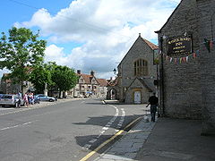
Somerton's market square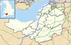
 Somerton
Somerton shown within SomersetPopulation 4,706 [1] OS grid reference ST485285 Parish Somerton District South Somerset Shire county Somerset Region South West Country England Sovereign state United Kingdom Post town SOMERTON Postcode district TA11 Dialling code 01458 Police Avon and Somerset Fire Devon and Somerset Ambulance South Western EU Parliament South West England UK Parliament Somerton and Frome List of places: UK • England • Somerset Somerton is a small town and civil parish in the South Somerset district of the English county of Somerset. It gave its name to the county of Somerset, was briefly, around the start of the 14th century, the county town, and around 900 AD was possibly the capital of Wessex. It has held a weekly market since the Middle Ages, and the main square with its market cross is today an attractive location for visitors. Situated on the River Cary, approximately 8.8 miles (14.2 km) north-west of Yeovil, the town has its own parish council serving a population of 4,706 as of 2002,[1] and an acreage of 6,620 acres (2,680 ha) as of 1894.[2] The civil parish includes the hamlets of Etsome and Hurcot.
The history of Somerton dates back to the Anglo-Saxon era, when it was an important political and commercial centre. A local legend has it that Ine, a Wessex king, was originally a farmer in Somerton. After the Norman conquest of England the importance of the town declined despite being the former county town of Somerset in the late thirteenth century and early fourteenth century. Despite losing county town status, Somerton then became a market town in the Middle Ages, whose economy was supported by transport systems using the River Parrett, and later rail transport via the Great Western Railway, and by light industries including glove making and gypsum mining.
In the centre of Somerton the wide market square, with its octagonal roofed market cross, is surrounded by old houses, while close by is the 13th century Church of St Michael and All Angels. Somerton also had links with Muchelney Abbey in the Middle Ages. The BBC drama The Monocled Mutineer was filmed in Somerton from 1985 to 1986.[3]
Contents
History
Further information: History of SomersetThe earliest reference to the town is in the Anglo-Saxon Chronicle, which records that in 733 the King of Wessex, Æthelheard lost control of Somerton to Ethelbald, King of Mercia.[4] A local legend has it that Ine of Wessex (688-728), who ruled Wessex for 37 years, was originally a farmer in Somerton.[5] Somerton was reputedly the capital of the Kingdom of Wessex from 871 to 901 AD, and though this is not supported by modern research,[6] it was the site of the 949 meeting of the witan, a form of Anglo-Saxon parliament.[7] The town returned to West Saxon royal control in the ninth century,[6] and it was listed in the Domesday Book of 1086 as "Sumertone". The name may come from Old English for "sea-lake enclosure", "summer town" or "summer farmstead".[8][4] The Somerton name was extended to the people in the area it controlled, and this area became known as Somerset, although Somerton soon ceased to be the most important settlement and never grew into a large town.[9] The parish was the largest in the Hundred of Somerton.[10][11] It was, briefly, the county town of Somerset from the late thirteenth century into the early fourteenth century.[12] A building referred to as "Somerset castle" is believed to have been built around 1280 as a county gaol,[13] with a visitor in 1579 describing the remaining portion as "an old tower embattled about castle-like".[14] It was owned by Sir Ralph Cromwell between 1423 and 1433.[15] Details are vague and visible remains have vanished,[16] so its status as a castle and its very existence is in doubt, with one writer, D.J.C. King, feeling that people were confusing it with Somerton Castle in Lincolnshire.[13]
The Abbots of Muchelney Abbey held the Rectorship of the parish church of Somerton during the Middle Ages. They built a tithe barn, to house the tithes of crops and produce paid by the parish to the town's Rector.[17] The Abbey was dissolved in 1539 during the English Reformation, and the tithes and the tithe barn passed into the ownership of Bristol Cathedral. In the 20th century the barn was converted into private housing.[17][18]
 Disused radio station built by the Marconi Company around 1925
Glove making was a major industry in the town in the early nineteenth century, along with the production of rope and twine.[19] The Somerton Brewery, owned by a local landowner named Thomas Templeman, was first recorded under the Tithe Apportionment Act of 1841. [20] The brewery became a large producer in Somerset until its final closure around 1935.[21] Before the National Insurance and the Health Service was introduced, Somerton Men's Club acted as a local Provident Society within the area.[22] Gypsum was extracted by hand at the Hurcott open-cast mine from the Victorian era up until it closed down in 1953.[23] In 1906, a railway station opened on the Castle Cary Cut-Off which was built by the Great Western Railway. Whilst the line still remains in use, the station was closed in 1962.[24] When the Marconi Company built the radio stations known as the Imperial Wireless Chain for the Post Office during 1925–26, they also established their own transmitting station at Dorchester with a receiving station 30 miles (48 km) away at Somerton.[25]
Somerton was hit by four Luftwaffe bombs on the morning of 29 September 1942 during the Second World War. The bombs were aimed at the Cow and Gate milk factory and it was largely destroyed. Ten nearby houses were badly damaged. Nine people were killed and thirty seven injured.[26] A memorial at the dairy site commemorates those killed.[27] The factory later became a district council depot, and was recently bought by the town council for possible use as the site of a new town hall.
Governance
The parish council has responsibility for local issues, including setting an annual precept (local rate) to cover the council's operating costs and producing annual accounts for public scrutiny. The parish council evaluates local planning applications and works with the local police, district council officers, and neighbourhood watch groups on matters of crime, security, and traffic.[28] The parish council's role also includes initiating projects for the maintenance and repair of parish facilities, as well as consulting with the district council on the maintenance, repair, and improvement of highways, drainage, footpaths, public transport, and street cleaning. Conservation matters (including trees and listed buildings) and environmental issues are also the responsibility of the council.[29] In October 2009, eleven of the local councillors resigned en-mass,[30] citing excessive criticism from local residents and in particular criticism from a hostile local weblog.[31]
The town falls within the Non-metropolitan district of South Somerset, which was formed on 1 April 1974 under the Local Government Act 1972, having previously been part of Langport Rural District.[32] The district council is responsible for planning permission and building control, local roads, council housing, environmental health, markets and fairs, refuse collection and recycling, cemeteries and crematoria, leisure services, parks, and tourism.[33] Somerset County Council is responsible for major services such as the Local Education Authority, social services, libraries, main roads, public transport, policing and fire services, trading standards, waste disposal and strategic planning.[34]
Somerton elects one Member of Parliament (MP) for Somerton and Frome county constituency, represented in the House of Commons of the Parliament of the United Kingdom, and is part of the South West England constituency of the European Parliament which elects six MEPs using the d'Hondt method of party-list proportional representation.
Geography
Somerton is situated on a plateau, above and to the south of the deep valley of the River Cary. The river flows west and then north through the Somerton Moor and then into King's Sedgemoor Drain on the Somerset Levels eventually joining the River Parret near Bridgwater.[35] The town is 116 miles (187 km) from London, 28 miles (45 km) south from Bristol and 9 miles (14 km) north-west from Yeovil, just off the Dorset border. Somerton's hamlets include Etsome, Hurcot, Lower Somerton and Littleton.[36] Great Breach Wood is a biological Site of Special Scientific Interest (SSSI) and is situated just 1.4 miles (2.3 km) north-east from Somerton, near the hamlet of Littleton.[37]
Somerton's climate is typical of the climate of south-west England which is usually cool winters with warmer summers and precipitation all year round, with more rain experienced in winter.[38]
Settlements and geographic features near Somerton 
Somerset Levels Glastonbury Mendip Hills Bridgwater 
Mendip Hills  Somerton

Langport Martock, South Petherton Yeovil Demography
The Somerton parish had a population of 4,706 as of 2002.[1] In the 1801 census the population of the town was 1,145. The population had risen to 2,140 in 1851 and then suddenly dropped to 1,917 ten years later. It was not until 1961 that the population of Somerton had risen above its former population in 1851, over a century ago.[39]
Economy
A weekly market has been held in Somerton for much of its history. The cloth industry dominated the town's market from the 17th century until the 20th century, when agriculture took over as the leading industry.[40] Some light industries and services, such as garage repair, physiotherapy, water treatment, and builders and decorators, are located in the business park on Bancombe Road.[41][42]
Landmarks
 The Butter Cross which was rebuilt in 1673
The main square, Market Place, with its market cross is today an attractive location for visitors.[43] Market crosses have stood in the square since before 1390; the present Butter Cross, a roofed market cross, was rebuilt in 1673, and is Somerton's most noted feature.[44] The structure was the property of the Earls of Ilchester who sold it to the town in 1916.[45] It is a Scheduled Ancient Monument.[46] Next to the Butter Cross stands the "Market Hall", previously known as the "Town Hall", although the building has never fulfilled either of these functions.[4][47] Bordering the square are the church, and the Lady Smith Memorial Hall, also known as the "Parish Rooms", which was built in 1902,[48] and the 17th century Market House, now a restaurant.[49] The Red Lion was opened by the Earl of Ilchester in 1768 as a model coaching inn. It closed in 1995; after a period of neglect it has been redeveloped as town houses.[50][51]
From the early 1980s onwards projects aiming to improve Somerton for film industry purposes have been undertaken.[52] The market square was heavily revamped, creating a central parking area with easy access to the local amenities.[53] The BBC drama The Monocled Mutineer was filmed in Somerton from 1985 to 1986.[3]
Somerton Court
Somerton Court, originally known as "Somerton Erleigh", was built in the 12th century. The house has had various owners including Edward IV's brother, the Duke of Clarence, and Henry Percy, 6th Earl of Northumberland, who sold the estate in 1530. It passed through a number of hands until 1597 when it was purchased by James Fisher, whose son later rebuilt it in 1641. The court remained in the Fisher family's possession until 1808 when it was sold. Its new owner renamed the house "Somerton Court", and replaced the gabled dormers with Gothic battlements and turrets. The house was later enlarged by the Hall-Stephenson family.[54][55] The house is set in 55 acres (220,000 m2) of parkland and gardens.
Transport
The town's former, and only, railway station was on the Castle Cary Cut-Off, once part of the Great Western Railway.[56] Although the line still remains in use the station closed to passengers in 1962,[24] and goods in 1964.[57] The nearest station is now at Yeovil.[58]
Despite Somerton being situated in a rural area; the closest main road from Somerton is the A303 road that runs near the town and stretches all the way into northern Hampshire and finally ends at Basingstoke.[59] The minor B3165 road does run through the town although the road is less commonly used and does not join to the A303 for another 4 miles (6.4 km).[60] Two B roads, the B3153 and the B3156 run through Somerton and a third, the B3165, starts in the town and runs southwards to the A372 Langport road.[61] The A372 itself runs south-east to the junction of the A303 and A37 roads at Podimore services.[62]
Religious sites
 St Michael's and All Angels church has origins which date from the 13th century.
The Anglican Church, St Michael's and All Angels, has origins which date from the 13th century, with a major reshaping in the mid 15th century, and further restoration in 1889. It is built of local lias stone cut and squared, with Hamstone dressing. It has been designated by English Heritage as a grade I listed building.[63]
It is notable for a carved roof, with lions and a small cider barrel purportedly carved by the monks of Muchelney Abbey.[63] Sir John Betjeman was also inspired by an inscription on the candelabra. The church is quite plain on the outside but inside is one of the finest wooden carved roofs in the county. It is shallow pitched with massive, richly decorated tie beams and short king posts. The whole area of the roof is divided into square carved panels set in the framework of the structural timbers which are decorated with carved bosses where they intersect.[64] There are 640 panels each carved with the same quatrefoil design.[63] In the triangular spaces above each beam are dragon-like beasts.[65] It is said there are bullet holes in the timbers, caused by soldiers who camped in the church in 1646 before the Battle of Langport.[64] The 17th century pulpit and altar table are Jacobean woodwork.[64] There are five other churches in the town, including Catholic and Methodist groups.[66]
Education
Somerton has two primary schools in the town, but no secondary schools. Children aged between 4 and 7 attend the County Infants' school at Etsome Terrace.[67] It has around 120 students in five classes that are named after flowers.[68] Older children (between 7 and 11 years) attend the Monteclefe CEVA Junior School on Kirkham Street, which provides the second part of primary education in the area.[69][70]
References
- ^ a b c "South Somerset population estimates for 2002". Somerset County Council. http://www.webcitation.org/5lRyCVNCk. Retrieved 27 December 2009.
- ^ "Somerton parish acreage". UK Genealogy Archives. http://www.uk-genealogy.org.uk/england/Somerset/towns/Somerton.html. Retrieved 26 July 2011.
- ^ a b Stewart, Ian; Susan Lisa Carruthers (1996). War, Culture, and the Media. Fairleigh Dickinson University Press. p. 67. ISBN 0838637027.
- ^ a b c Bush, Robin (1994). Somerset: The complete guide. Wimbourne: Dovecote Press. pp. 184–185. ISBN 1-874336-27-X.
- ^ "King Ina (Somerton)". Somerton Web Museum. http://www.somertonmuseum.org.uk/index.php?table=pages&idnum=73. Retrieved 17 October 2011.
- ^ a b Richardson, Miranda (2003). "An archaeological assessment of Somerton" (PDF). English Heritage Extensive Urban Survey. Somerset County Council. pp. 3–4. http://www1.somerset.gov.uk/archives/hes/downloads/EUS_SomertonText.pdf. Retrieved 26 July 2011.
- ^ "Somerset Historic Environment Service". www1.somerset.gov.uk. 2011 [last update]. http://www1.somerset.gov.uk/archives/hes/eus/somerton_eus.htm. Retrieved 10 November 2011.
- ^ Robinson, Stephen (1992). Somerset Place Names. Wimbourne: The Dovecote Press. pp. 122–123. ISBN 1-874336-03-2.
- ^ "Somerton history". Somerton Website. http://www.somerton.co.uk/index.php?id=24. Retrieved 3 August 2011.
- ^ R. W. Dunning (editor), A. P. Baggs, R. J. E. Bush, Margaret Tomlinson (1974). "Somerton hundred". A History of the County of Somerset: Volume 3. Institute of Historical Research. http://www.british-history.ac.uk/report.aspx?compid=66487. Retrieved 19 October 2011.
- ^ "Local History". Somerton. http://www.somerton.co.uk/index.php?id=24. Retrieved 19 October 2011.
- ^ Lambert, Tim. "A Brief History of Somerton". A World History Encyclopedia. http://www.localhistories.org/somerton.html. Retrieved 18 August 2009.
- ^ a b "CastleFacts". castlefacts.info. 2011 last update. http://castlefacts.info/contentpages/castledetails/castledetails.asp?country=England&countyid=36&county=Somerset&castleid=3504&latitude=51.0521&longitude=-2.7277&uin=13280. Retrieved 2 October 2011.
- ^ Dunning, Robert (1995). Somerset Castles. Somerset books. p. 79. ISBN 0-86183-278-7.
- ^ Ralph Alan Griffiths (1981). The reign of King Henry VI: the exercise of royal authority, 1422–1461. University of California Press. p. 69. ISBN 9780520043725. http://books.google.co.uk/books?id=frWDmbf_mXEC&pg=PA69. Retrieved 2 October 2011.
- ^ "Somerton Castle (site of), Somerton". Somerset Historic Environment Record. Somerset County Council. http://webapp1.somerset.gov.uk/her/details.asp?prn=15706. Retrieved 18 August 2009.
- ^ a b "Tithe Barn". Somerton Web Museum. http://www.somertonmuseum.org.uk/index.php?table=subcat&idnum=45. Retrieved 5 August 2011.
- ^ "The Old Barn". Images of England. English Heritage. http://www.imagesofengland.org.uk/details/default.aspx?id=263021. Retrieved 24 September 2007.
- ^ "Somerton (St. Michael)". A Topographical Dictionary of England. British History Online. 1848. http://www.british-history.ac.uk/report.aspx?compid=51287#s10. Retrieved 18 August 2009.
- ^ "Somerton Brewery owners". Somerton Website. http://www.somerton.co.uk/index.php?id=111. Retrieved 3 August 2011.
- ^ "The Somerton Brewery". Somerton Website. http://www.somerton.co.uk/page/brewery/108/. Retrieved 31 July 2011.
- ^ "Somerton's Men Club". Somerton town. http://www.visitoruk.com/historydetail.php?id=30905&cid=592&f=Glastonbury. Retrieved 31 July 2011.
- ^ "Alabaster mine". Somerton Web Museum. http://www.somertonmuseum.org.uk/index.php?table=subcat&idnum=42. Retrieved 24 September 2007.
- ^ a b "A History of Somerton". Local Histories. Tim Lambert. http://www.localhistories.org/somerton.html. Retrieved 5 August 2011.
- ^ "Dorchester Radio Station". South Dorset Radio Society. http://sites.google.com/site/southdorsethamradio/history/dbs. Retrieved 26 July 2011.
- ^ Hawkins, Mac (1996) Somerset at War, 1930-1945, Hawk Editions, p 76
- ^ "The Memorial Garden at Somerton". Somerton Community Website. http://www.somerton.co.uk/page/memorial_gardens/127. Retrieved 26 July 2011.
- ^ "Somerton CP Neighbourhood watch". Avon and Somerset Constabulary. http://www.avonandsomerset.police.uk/localpages/BeatDetails.aspx?BeatID=311. Retrieved 9 August 2011.
- ^ "Somerton Environmental monitoring". Somerset County Council. http://www.somerset.gov.uk/irj/public/services/directory/service?rid=/wpccontent/Sites/SCC/Web%20Pages/Services/Services/Environment/Environmental%20monitoring. Retrieved 9 August 2011.
- ^ "Councillors resign en masse after criticism by blogger". London: The Guardian. 30 October 2009. http://www.guardian.co.uk/politics/2009/oct/30/councillors-resign-en-masse-blogger. Retrieved 31 October 2009.
- ^ "Blog sparks mass council walkout". BBC News. 30 October 2009. http://news.bbc.co.uk/1/hi/programmes/newsnight/8335153.stm. Retrieved 31 October 2009.
- ^ "Unit history of Langport". A vision of Britain through time. http://www.visionofbritain.org.uk/relationships.jsp?u_id=10054928&c_id=10001043. Retrieved September 13, 2011.
- ^ "South Somerset District Council - About us". southsomerset.gov.uk. 2011 [last update]. http://www.southsomerset.gov.uk/about-us.aspx. Retrieved 1 November 2011.
- ^ "Somerset County Council: Council Structure". somerset.gov.uk. 2011 [last update]. http://www.somerset.gov.uk/irj/public/council/departments/department?rid=/guid/7048864d-f901-2d10-489a-9bd0dc550020. Retrieved 1 November 2011.
- ^ Tatem, K. W.; I.D. Sturdy and Miwem Mice (1994). "Somerset levels and moors water level management and nature conservation strategy". Wetland Management. Thomas Telford, Ltd.. pp. 88–105. ISBN 0-7277-1994-7. http://books.google.com/?id=OQmpDU-wQ40C&pg=PA88#PPA88,M1.
- ^ "Somerton Civil Parish Settlements". Somerton Website. http://www.somerton.co.uk/page/etsome_dairy_farm/136. Retrieved 3 August 2011.
- ^ "Great Breach Wood". The Wildlife Trusts. http://www.wildlifetrusts.org/reserves/great-breach-wood. Retrieved 31 July 2011.
- ^ "South West England: climate". Met Office. http://www.metoffice.gov.uk/climate/uk/sw/. Retrieved 14 March 2010.
- ^ "Somerton CP: Total Population". A Vision of Britain Through Time. Great Britain Historical GIS Project. http://www.visionofbritain.org.uk/data_cube_page.jsp?data_theme=T_POP&data_cube=N_TOT_POP&u_id=10441584&c_id=&add=N. Retrieved 8 August 2011.
- ^ Robert William Dunning (1992). A history of the county of Somerset , Volume 3. Constable. pp. 170–171. http://books.google.com/?id=GPbuAAAAMAAJ&q=somerton+economic+somerset&dq=somerton+economic+somerset.
- ^ "Somerton business park". Zoopla. http://www.zoopla.co.uk/home-values/somerset/somerton/bancombe-road/somerton-business-park/. Retrieved 9 August 2011.
- ^ "Garage and repair services". Somerton website. http://www.somerton.co.uk/business/Garage%20Repairs%20and%20Services/. Retrieved 9 August 2011.
- ^ Haskell, Tony (1993). Caring for our built heritage. Taylor & Francis. p. 213. http://books.google.co.uk/books?id=4VqHd0kQL3YC&pg=PA213#v=onepage&q&f=false. Retrieved 10 November 2011.
- ^ "Somerton Web Museum - Butter Cross". Somerton Web Museum. http://www.somertonmuseum.org.uk/index.php?table=subcat&idnum=27. Retrieved 6 November 2011.
- ^ "The Market Cross". Images of England. English Heritage. http://www.imagesofengland.org.uk/details/default.aspx?id=262965. Retrieved 24 September 2007.
- ^ "Somerton Market Cross". Pastscape National Monument Record. English Heritage. http://www.pastscape.org.uk/hob.aspx?hob_id=193506. Retrieved 2 October 2011.
- ^ "The Market Hall (formerly listed as the Town Hall)". Images of England. English Heritage. http://www.imagesofengland.org.uk/details/default.aspx?id=262966. Retrieved 24 September 2007.
- ^ "Parish Rooms". Somerton Web Museum. http://www.somertonmuseum.org.uk/index.php?table=subcat&idnum=47. Retrieved 24 September 2007.
- ^ "The Market House". Images of England. English Heritage. http://www.imagesofengland.org.uk/details/default.aspx?id=262982. Retrieved 24 September 2007.
- ^ "Red Lion". Images of England. English Heritage. http://www.imagesofengland.org.uk/details/default.aspx?id=262983. Retrieved 24 September 2007.
- ^ "Red Lion". Somerton Web Museum. http://www.somertonmuseum.org.uk/index.php?table=subcat&idnum=36. Retrieved 24 September 2007.
- ^ "Somerton walk around the Square". Somerton Website. http://www.somerton.co.uk/page/an_interesting_walk_around_the_town/132. Retrieved 3 August 2011.
- ^ "Somerton Town Plan 2005" (PDF). South Somerset Council. http://ww2.southsomerset.gov.uk/media/pdf/s/b/Somerton_Summary_ebook.pdf. Retrieved 29 September 2010.
- ^ "Somerton Court". Somerton Court Country House. Archived from the original on 11 January 2008. http://web.archive.org/web/20080111052009/http://www.somertoncourt.co.uk/catalog/product_info.php?products_id=45. Retrieved 24 September 2007.
- ^ "Somerton Court". Images of England. English Heritage. http://www.imagesofengland.org.uk/details/default.aspx?id=263023. Retrieved 24 September 2007.
- ^ "Somerton Cary Cut-Off Railway". Somerton Website. http://www.somerton.co.uk/history/virtualtour/4/. Retrieved 5 August 2011.
- ^ "Parishes: Somerton". ', A History of the County of Somerset: Volume 3 (1974), pp. 129-153.. British History Online. http://www.british-history.ac.uk/report.aspx?compid=66494. Retrieved 4 October 2011.
- ^ "Yeovil Railway centre". DAYoutWITHtheKIDS. http://www.dayoutwiththekids.co.uk/family-fun/Yeovil_Railway_Centre/3028. Retrieved 5 August 2011.
- ^ The National Archives file MT39/246 : "CLASSIFICATION : Renumbering of classified routes"
- ^ "B3165 road (Somerset)". Sabre-roads. http://www.sabre-roads.org.uk/wiki/index.php?title=B3165_%28Somerset%29. Retrieved 3 August 2011.
- ^ "B3165 road (Somerset)". Sabre-roads. http://www.sabre-roads.org.uk/wiki/index.php?title=B3165_%28Somerset%29. Retrieved 3 August 2011.
- ^ The National Archives file MT39/246 : "CLASSIFICATION : Renumbering of classified routes"
- ^ a b c "Church of St Michael and All Angels". Images of England. English Heritage. http://www.imagesofengland.org.uk/details/default.aspx?id=262971. Retrieved 15 June 2009.
- ^ a b c "St Michael & All Angels". Somerton Web Museum. http://www.somertonmuseum.org.uk/index.php?table=subcat&idnum=19. Retrieved 24 September 2007.
- ^ R. W. Dunning (editor), A. P. Baggs, R. J. E. Bush, Margaret Tomlinson (1974). "Parishes: Somerton". A History of the County of Somerset: Volume 3. Institute of Historical Research. http://www.british-history.ac.uk/report.aspx?compid=66494#s6. Retrieved 09 November 2011.
- ^ "Churches together in Somerset (CTIS)". Somerton Website (CTIS). http://www.somerton.co.uk/page/churchestogetherinsomerton/71. Retrieved 3 August 2011.
- ^ "Schools in Somerton". Alltheschools. http://www.alltheschools.com/somerset/somerton.htm. Retrieved 31 July 2011.
- ^ "Somerton Infant School". Somerton County Infants' school. http://www.somertoninfantschool.co.uk/. Retrieved 31 July 2011.
- ^ "Monteclefe CE VA Junior School". Monteclefe CE VA Junior School. http://monteclefe-somerset.frogprimary.com/. Retrieved 26 July 2011.
- ^ "Monteclefe CofE Primary School". Monteclefe CofE Primary School. http://monteclefe.educatr.com/parents/welcome. Retrieved 31 July 2011.
- Victoria History of the County of Somerset: Vol 3: Somerton, R.W.Dunning (1974)
External links
- Somerton at the Open Directory Project
- The Somerset Urban Archaeological Survey: Somerton, by Miranda Richardson
Ceremonial county of Somerset Unitary authorities Boroughs or districts Major settlements - Axbridge
- Bath
- Bridgwater
- Bruton
- Burnham-on-Sea
- Castle Cary
- Chard
- Clevedon
- Crewkerne
- Dulverton
- Frome
- Glastonbury
- Highbridge
- Ilminster
- Keynsham
- Langport
- Midsomer Norton
- Minehead
- Nailsea
- North Petherton
- Portishead
- Radstock
- Shepton Mallet
- Somerton
- South Petherton
- Taunton
- Watchet
- Wellington
- Wells
- Weston-super-Mare
- Wincanton
- Wiveliscombe
- Yeovil
See also: List of civil parishes in Somerset
Rivers - Alham
- Aller
- Avill
- Avon
- Axe (Bristol Channel)
- Axe (Lyme Bay)
- Badgworthy Water
- Banwell
- Barle
- Brue
- Cam Brook
- Cary
- Chew
- East Lyn
- Exe
- Fivehead
- Frome
- Haddeo
- Hoar Oak Water
- Holford
- Horner
- Huntspill
- Isle
- Land Yeo
- Mells
- Midford Brook
- Oare Water
- Parret
- Severn Estuary
- Sheppey
- Somer
- Sowy
- Tone
- Washford
- Wellow Brook
- West Lyn
- Whitelake
- Yeo (Congresbury)
- Yeo (South Somerset)
Topics - County Council
- Culture of Somerset
- Economy of Somerset
- Geography of Somerset
- Geology of Somerset
- History of Somerset
- Museums
- Transport in Somerset
Geographic areas: Blackdown Hills - Brendon Hills
- Chew Valley
- Exmoor
- Mendip Hills
- Polden Hills
- Quantock Hills
- Somerset Levels
- South West Coast Path
- West Somerset Coast Path
Categories:- Towns in Somerset
- Somerset Levels
- South Somerset
- Market houses
- Civil parishes in Somerset


Wikimedia Foundation. 2010.