- Cape Lookout Lighthouse
Infobox_lighthouse|name=Cape Lookout Lighthouse
location=Cape Lookout (North Carolina)
height=163 feet
yearlit = 1859
automated=1950
construction = brick
shape = Conical tower
range = 12-19 miles
characteristic = 15-second flash cycle
admiralty = J2430
ARLHS = USA-126
USCG = 2-0670
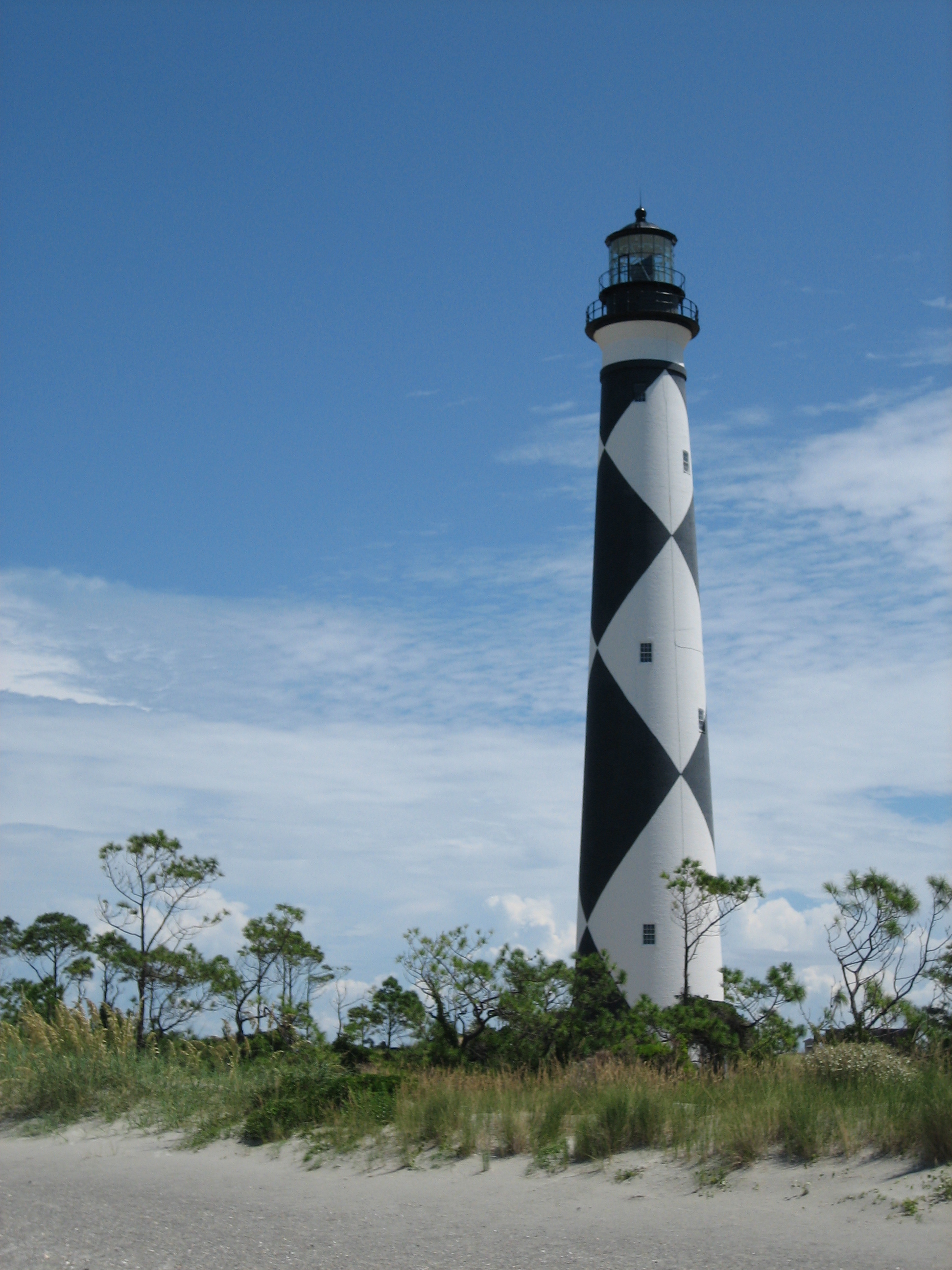
coordinates = coord|34|36|19|N|76|32|10|WThe Cape Lookout Lighthouse is a 163-foot high lighthouse located on the SouthernOuter Banks ofNorth Carolina . It flashes every 18 seconds and is visible at least 12 miles out to sea and up to 19 miles. The Cape Lookout Light is one of the very fewlighthouse s that operate during the day. It became fully automated in 1950. [Historic.] The Cape Lookout Lighthouse is the only such structure in the United States to bear the checkered daymark, intended not only for differentiation between similar light towers, but also to show direction. The black diamonds point in a north-south direction, while the white diamonds point east-west.History
It is the second lighthouse that has stood at this location, and is nearly identical to the
Bodie Island Lighthouse modeled after it, which has horizontal stripes. The more famousCape Hatteras Lighthouse bears spiral stripes. The first lighthouse at Cape Lookout was completed and lighted in 1812 at a cost of more than $20,000, which Congress authorized in 1804. It was the fourth lighthouse to be built in North Carolina and was a 96 foot high brick tower painted with red and white horizontal stripes. But it proved to be too short to light the treacherous coast. The present lighthouse was completed in 1859 at a cost of $45,000, which Congress approved in 1857. In 1873, the lighthouse was painted in its distinctive black and white diagonal checkerboard pattern. There are those who believe the Cape Hatteras Light and the Cape Lookout Light paint schemes were reversed. This belief arose since the Cape Hatteras Light protects ships from Diamond Shoals and should therefore have the diamond pattern. [Cape.]Diamond City , a community that once stood on the eastern end ofShackleford Banks , was named after the daymark pattern on the nearby Cape Lookout Lighthouse.The lighthouse is part of the
Cape Lookout National Seashore and can only be accessed by private ferry. A few times a year, visitors are allowed to climb the 201 spiral iron steps to the top of the lighthouse. During the summer, the Cape Lookout Light Station Visitor Center and Keepers' Quarters are also open. [Lighthouse.]Timeline
Quote box2
width = 85%
border = 4px
align = center
bgcolor = #cce5ff
title_bg =
title_fnt =
title = Historic Light Station Information - NORTH CAROLINA
halign = left
quote = CAPE LOOKOUT LIGHT:
* The Cape Lookout Lighthouse was completed in 1812 at a cost of $20,678.54 and had one wooden and one brick tower.
* The station was described in 1850, when William Fulford was keeper, as having 13 lamps, new lighting apparatus having been installed in 1848. The keeper was obliged, in 1850, to keep wheeling away sand from the front side of the keeper’s dwelling to prevent the sand from covering it up. "The sand banks," the report reads, "are now higher than the tops of the windows; and only a few feet from them, at high water mark. On the sea side, it has washed away about 100 feet last year by abrasion and sea flows."
* In 1851 Cape Lookout Lighthouse was reported as one of nine coast lights "which require to be improved. The towers of each of them should have an elevation of 150 feet above the level of the sea and should be fitted up in the best manner with first-order lens apparatus, to insure a brilliancy and range adequate to the wants of commerce. These lights are not sufficiently well distinguished, but a general plan for all the seacoast lights will best accomplish this object."
* On March 3, 1857, Congress appropriated $45,000 "for rebuilding and fitting out with first-order apparatus the lighthouse at Cape Lookout, North Carolina." The new lighthouse was completed and first lighted on November 1, 1859. During the Civil War, in 1862, the tower was damaged and the lens, etc., removed, but by 1863 the lighthouse had been refitted and the light reexhibited. A third-order lens was placed in use temporarily until the first-order lens, "injured by the rebels" could be repaired and restored in 1867.
* The lighthouse is now a black and white diagonally checkered tower, 169 feet above ground and 156 feet above feet water and shows a group flashing white electric light every 15 seconds of 80,000 candlepower, visible 19 miles, from a first-order lens.
salign = right
source = United States Coast Guard [Historic.]References
* [http://www.rickslighthouses.com/cape_lookout.htm Cape Lookout] . 2000. Rick Totten. Rick's Lighthouses. Retrieved 2008-08-17.
* [http://www.uscg.mil/history/weblighthouses/LHNC.asp Historic Light Station Information and Photography - NORTH CAROLINA] . U.S. Coast Guard. Retrieved 2008-08-17.
* [http://www.nps.gov/calo/parknews/02_22_2008.htm "Lighthouse Climbs Suspended For Public Safety"] . 2008-02-23. National Park Service. Retrieved 2008-08-17.Notes
External links
* [http://www.nps.gov/calo/ Cape Lookout National Seashore]
* [http://www.carolinalights.com/north-carolina-lighthouses/cape-lookout-lighthouse Cape Lookout on CarolinaLights.com]
* [http://www.uscg.mil/history/weblighthouses/LHNC.asp U.S. Coastguard Historic Light Station Information]
Wikimedia Foundation. 2010.