- Northeastern United States blizzard of 1978
-
This article is about the storm which affected the northeastern United States. For the blizzard in the central United States that year, see Great Blizzard of 1978.
Blizzard of 1978 Maple Street in Woonsocket, RI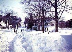
Storm type: Winter storm Formed: February 5, 1978 Dissipated: February 7, 1978 Damages: $520,000,000 (1978 dollars), (USD)=1.75 billion (2010 dollars) Fatalities: approximately 100 Areas affected: Northeastern United States The Northeastern United States blizzard of 1978[1][2] was a catastrophic and historic nor'easter that brought blizzard conditions to the New England region of the United States and the New York metropolitan area. The "Blizzard of '78" formed on February 5, 1978 and broke up on February 7, 1978.[3] Snowfall occurred primarily between Monday morning, February 6 and the evening of Tuesday, February 7. Connecticut, Rhode Island, and Massachusetts were particularly hard hit by this storm.
Boston received a record 27.1 inches (69 cm) of snow; Providence, Rhode Island, also broke a record, with 27.6 inches (70 cm) of snow.[3] The storm killed approximately 100 people in the Northeast and injured around 4,500.[3] The storm also caused over US$520 million (US$1.75 billion in present terms[4]) in damage.[3]
Contents
Meteorological history
The storm was formed from an extra-tropical cyclone off the coast of South Carolina on February 5. An Arctic cold front and a cold air mass then merged with the storm, creating the perfect ingredients for a large and intense low-pressure system.[3]
This storm system made its way up the coast, and approached southern New England late February 6 and early February 7. Since the storm developed during a new moon, an unusually large high tide occurred, and the storm brought a massive amount of water along coastal communities.[3] The huge storm surge resulted in broken sea walls and massive property loss.[3]
Strong winds and extremely heavy precipitation brought zero visibility for travelers, and numerous power outages ensued. The precipitation changed to rain on Cape Cod, reducing the total snowfall, but snow continued in the west. By the time the storm ended, thousands of people were stranded and homeless as a result of the storm.[3]
Storm strength
The storm's power was made apparent by its sustained hurricane-force winds of approximately 86 mph (138 km/h) with gusts to 111 mph (179 km/h) and the formation of an eye-like structure in the middle of the storm.[5] While a typical nor'easter brings steady snow for six to twelve hours, the Blizzard of '78 brought heavy snow for an unprecedented full 33 hours as it was blocked from heading into the North Atlantic by the strong Canadian high pressure area.[3]
An atypical vertical development of storm clouds brought unusual thundersnow to southern New England and Long Island. These storms resulted in lightning and thunder accompanying the snowfall as it fell at 4 inches (10 cm) an hour at times.
Impact
Conditions
 Maple Street, Woonsocket, RI
One of the major problems with the Blizzard of 1978 was the lack of foreknowledge about the storm's severity. Weather forecasting in New England is difficult, and meteorologists had developed a reputation as being inaccurate. Forecasting techniques and technology had improved dramatically in the 1970s, but the public was still quite skeptical. Snow failed to arrive in Monday's pre-dawn hours as predicted, and many locals felt it to be another failed forecast — despite the accuracy of NWS forecasters' predictions concerning the Great Blizzard — and they went to work and school as normal. Because of this, people had neither time nor incentive to prepare.[6]
The Commonwealth of Massachusetts had a system for notifying major employers to send employees home early in the event of heavy storms. Thousands of employees were sent home starting in the early afternoon of February 6,[7] but thousands more were still caught by the storm. Some did not make it home for several days.
Many people were stranded in their cars along roads and highways throughout the New England region. People perished on Interstate 95 outside Boston as snow piled high enough to prevent the exhaust from escaping from their idling vehicles. Interstate 95 eventually had to be evacuated by cross-country skiers and snowmobilers. More than 3,500 cars were found abandoned and buried in the middle of roads during the clean-up effort. This figure does not include the countless other vehicles buried in driveways, on the sides of streets, and in parking lots. Other transportation links were disrupted and shut down region-wide, stranding public transit commuters in city centers.
Throughout eastern Massachusetts, automobile traffic was banned for the remainder of the week. Thousands of people walked around the quiet city streets and frozen Charles River, some on cross-country skis.
This blizzard was one of the worst in Rhode Island's history, catching many residents, as well as the state government, off guard. Although Governor J. Joseph Garrahy had ordered an emergency evacuation of all public buildings, shortly before noon on February 6, too many people had lagged. Providence County, Rhode Island was the hardest hit by the blizzard; in particular, the towns of Lincoln, Smithfield, Woonsocket, and North Smithfield all reported at least 40 inches (100 cm) of total snowfall.[3]
In New York City, it was one of the rare times that a snowstorm closed the schools; in fact, the New York City Board of Education would only close schools again due to snow once in the next 18 years (April 7, 1982). Most suburban districts in the area close for snow several times each winter, but they rarely do in the city itself because of relatively easy access to underground subways whose ability to run is not appreciably affected by moderate snowstorms.
 While the Massachusetts Institute of Technology was closed, students created other projects
Many people were caught in the storm while driving, and many others were trapped in their homes or offices with snow drifts of up to 15 feet (4.6 m), in some places blocking the exits. In many cases, those who had become ill or had been injured during the storm had to be taken to hospitals by snowmobile. Other people were able to leave their homes and travel for assistance by cross-country skis and sleds. One unofficial report stated that 4% of the students, staff, and faculty at Brown University in Providence, Rhode Island, incurred some sort of injury requiring medical attention as a result of the blizzard.[citation needed]
On the evening of the blizzard, two Brown students who were also Red Cross volunteers were able to make their way on snowshoes to the Providence office of the Red Cross. All the regular Red Cross disaster staff were stranded at their homes. People from throughout the city called the office to ask for food and other supplies. Many of these people had abandoned their cars on I-195 and found their way to makeshift shelters in various buildings near the highway. At 2 a.m., the two students loaded backpacks full of supplies from the Red Cross stockrooms and headed out toward the shelters. They encountered high winds and cars covered in feet of snow. One Providence fire truck was stranded across an intersection in Fox Point, its red lights spinning and firemen asleep in the cab. The students were able to reach shelters with food and supplies, and headed back to the Red Cross office. At 5 a.m., they borrowed snowshoes and skis from the Brown Outing Club and contacted the media to recruit neighbors and students who were skilled in winter travel. More than 500 students and neighbors took shifts around the clock delivering supplies to private homes and makeshift shelters across Providence. At one point, a National Guard helicopter landed on the school's athletic field to refresh the Red Cross supplies. These volunteers were part of a larger effort of citizens taking care of each other for days, awaiting rescue by National Guard units from the Carolinas who came equipped with front-loaders large enough to begin moving snow off the streets of Providence.
There was also the issue of flooding along coastal areas. The fierce northeast winds from the storm — with the low pressure area stalled off of Martha's Vineyard — combined with astronomically high tides and storm surge resulting from the storm's low pressure to send water over low-lying land along the shores of Long Island Sound, Cape Cod Bay, and other bodies of water, resulting in some of the worst coastal flooding ever recorded. The flooding continued through two days of tide cycles, a total of four successive high tides. Thousands of homes throughout coastal Massachusetts were damaged or destroyed, as well as landmarks such as "Motif Number 1" in Rockport, an oft-painted fisherman's shack renowned in art circles.[citation needed] The Peter Stuyvesant, a former Hudson River Day Liner turned into a floating restaurant, was sunk in Boston Harbor. The region's fishing fleet was likewise decimated by the storm.[8]
Aftermath and recovery
Boston and Providence recorded all-time highs for 24-hour and storm snowfall records.[3] Many people were left without heat, water, food, and electricity for over a week after the storm finished. Approximately 10,000 people were forced to move temporarily into emergency shelters. Some 2,500 houses were reported seriously damaged or destroyed and 54 people were killed, many from fallen electric wires. Several people were found dead in downtown Providence, Rhode Island, particularly in the vicinity of the central police station, who may have died trying to seek shelter. Ten-year-old Peter Gosselin, of Uxbridge, Massachusetts, disappeared in the deep snow just feet from his home's front door but was not found until three weeks later.[9] The majority of the interstate system had to be shut down, with some stretches not reopening to traffic until the following week. Air and rail traffic also had to be shut down until the situation cleared up.
Because the snowfall rates were so high, plows could not keep up with removal as fresh amounts fell, causing it to pile up too high to be plowed easily. Plows were further hampered by the number of cars stuck on the roads because of the heavy snow. In Boston, the snow drifts and levels were so high that the city's sanitation department was overwhelmed, as there was no more room to put the snow, so much of the snow had to be hauled and dumped in nearby harbors. Throughout the region, the high winds caused enormous drifts.
A state of emergency was declared by governors in the affected states and the United States National Guard was called out to help clear the roads. Additional troops were flown into Boston to assist. It took six days to clear the roads as cars and trucks buried under the snow needed to be removed before the routes could be opened. The blizzard brought out a feeling of camaraderie, as it affected everyone equally. Neighbors assisted each other, using sleds to transport elderly persons and helping to deliver groceries for those in need. Governor Ella Grasso ordered all roads in Connecticut closed except for emergency travel, effectively shutting down the state for three days; Governor Michael Dukakis of Massachusetts did the same.
Extensive beach erosion occurred on the east coast of Massachusetts. Especially hard-hit were Cape Cod and Cape Ann, both on the eastern shore of Massachusetts. Duxbury Beach was hit with 85 mph (137 km/h) gusts. In Truro, on Cape Cod, the Atlantic Ocean broke through to the Pamet River for the first time during this storm, completely washing away the link between the North and South Pamet roads. The town chose not to reconstruct the link, though the right-of-way is still open to pedestrians.
Many homes along the New England and Long Island coastlines were destroyed or washed into the ocean. Many roof collapses occurred across New England from the snow (although not that of the Hartford Civic Center, which had collapsed a few weeks earlier in the morning of January 18, 1978[10] during another snowstorm).
References
- ^ "The Blizzard of 1978: The week the state stood still."
- ^ "The Blizzard of 1978: Seacoast SAD, February 15, 1978"
- ^ a b c d e f g h i j k NWS Boston Page of the 1978 blizzard
- ^ Consumer Price Index (estimate) 1800–2008. Federal Reserve Bank of Minneapolis. Retrieved December 7, 2010.
- ^ "The Northeast Blizzard Of 1978"
- ^ "The Blizzard of '78... Revisited" National Weather Service.
- ^ "A look back at the Blizzard of 1978". The Boston Globe. http://www.boston.com/news/weather/gallery/013108_78blizzard/.
- ^ Fahey, Rich (February 7, 2008). "A blizzard too furious to forget". The Boston Globe. http://www.boston.com/news/local/articles/2008/02/07/a_blizzard_too_furious_to_forget/.
- ^ "A defining event in R.I. history"
- ^ "Hartford Civic Center Arena Roof Collapse"
Further reading
- Altimari, Daniela, 1998 "Blizzard Of 1978: Feb. 6-7, 1978: The Blizzard Of '78 Shut Down The State And Made Heroes Out Of Those With Four-Wheel Drive", Hartford Courant, February 25, 1998
- Earls, Alan R., and Dukakis, Michael S., Greater Boston's Blizzard of 1978, Arcadia Publishing, 2008, ISBN 978-0738555195
External links
Blizzards in the United States 19th century 20th century 21st century Categories:- 1978 meteorology
- 1978 natural disasters
- Blizzards in the United States
- Natural disasters in Connecticut
- Natural disasters in Massachusetts
- Natural disasters in New Jersey
- Natural disasters in New York
- Natural disasters in Rhode Island
- Nor'easters


Wikimedia Foundation. 2010.