- U.S. Route 41
-
U.S. Route 41
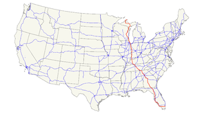
Route information Length: 2,000 mi[1] (3,219 km) Existed: 1926[1] – present Major junctions South end:  US 1 in Miami, FL
 I-10 near Lake City, FL
 I-20 at Atlanta, GA
 I-24 at Chattanooga, TN
 I-440 at Nashville, TN

 I-40 / I-65 at Nashville, TN
 I-64 near Evansville, IN
 I-70 at Terre Haute, IN
 I-74 at Veedersburg, IN


 I-80 / I-90 / Ind. Toll Rd. at Hammond, IN
 I-55 at Chicago, IL
 I-43 at Milwaukee, WI
 US 2 at Powers, MI
North end: Ft. Wilkins State Park near Copper Harbor, MI Highway system United States Numbered Highways
List • Bannered • Divided • ReplacedU.S. Route 41 is a north–south United States Highway that runs from Miami, Florida to the Upper Peninsula of Michigan. Until 1949, the part in southern Florida, from Naples to Miami, was U.S. Route 94, which presently has the hidden designation of State Road 90 in addition to its signed number, US 41.
The highway's northern terminus is east of Copper Harbor, Michigan, at a modest cul-de-sac near Fort Wilkins Historic State Park at the tip of the Keweenaw Peninsula in the state's Upper Peninsula. Its southern terminus is in the Brickell neighborhood of Downtown Miami at an intersection with Brickell Avenue (U.S. Route 1). It closely parallels Interstate 75 from Naples, Florida, all the way through Georgia to Chattanooga, Tennessee.
Contents
Route description
Florida
See also: Tamiami TrailIn Florida, US 41 is paralled by Interstate 75 all the way from Georgia (on the northern border) to Miami, and I-75 has largely supplanted US 41 as a major highway.
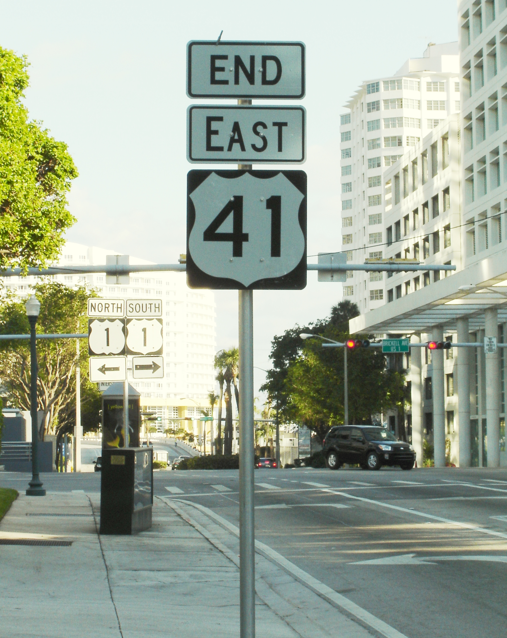
 The southern terminus of US 41 at U.S. Route 1 in Miami
Between Miami and Naples, US 41 cuts across the Florida peninsula, running through the vast Everglades wilderness. This section has been designated a National Scenic Byway. The byway runs east–west through the Big Cypress National Preserve, skirting the northern border of the Everglades National Park for about 20 miles (32 km). The part of the highway between Tampa and Miami is known as the Tamiami Trail (derived from the combination of Tampa and Miami, the road's two termini), thus, this section of the road is commonly known as the East Trail, as it runs east-west across the state, in contrast to the road's otherwise distinctively north-south route. In Naples, Route 41 changes direction at an intersection, turning from west to north towards Tampa (or from south to east towards Miami).
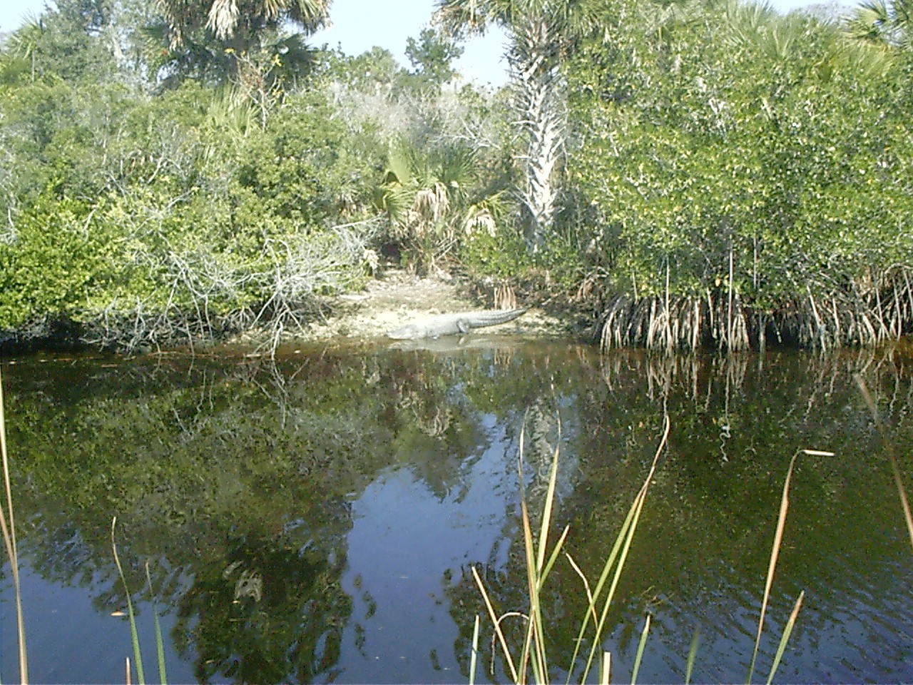
 Alligators are a common sight along the scenic Tamiami Trail from Miami to Naples. Unlike the parallel road, Alligator Alley, the trail is only one lane in each direction, and it has no fences to keep wildlife from crossing it.
US 41 is in the process of being widened throughout the northern Tampa Bay suburbs. It is currently six lanes wide between Tampa, Lutz, and much of Land O' Lakes, and again between Garden Grove and Brooksville. It is also four lanes wide in Tampa south of BUS US 41, between a section north of Land O' Lakes, Masaryktown, and Garden Grove, and south of Inverness. A large portion of US 41 is co-designated along the unmarked Florida State Road 45 between Belle Meade and High Springs.
From US 92 in Tampa to US 41 Business and State Road 676 near the unincorporated Palm River-Clair Mel, US 41 carries the unsigned State Road 599 designation. It contains the northwestern end of the Tamiami Trail at the SR 60 intersection. It is normally three lanes wide, but between Interstate 4 and the northern terminus of SR 569 is only two lanes wide. The unsigned state highway is 5.6 miles (9.0 km) long. At the northern terminus, US 41 turns west. (If one continues straight, 40th Street leads to Busch Gardens Tampa Bay.) Major intersections include State Road 574, SR 569, I-4, SR 60, and the Lee Roy Selmon Expressway (SR 618).
In Northern Florida, US 41 runs along the DeSoto Trail between Lake City and High Springs, and again between Williston and Floral City.
Georgia
In Georgia, US 41 is paralleled by Interstate 75 all the way from Tennessee to Florida, and I-75 has largely supplanted US 41 as a major highway.
In Atlanta, Highway 41 was formerly carried on Spring Street near Five Points, but it has long been re-routed via Northside Drive around the downtown area. (It was a major truck route.) The Georgia Dome, Georgia World Congress Center and Philips Arena are located off Northside Drive. South of Atlanta, Metropolitan Parkway and Tara Boulevard carry the highway, along with its co-signed partner US 19, toward Griffin. North of Atlanta, the stretch of Highway 41 between Atlanta and Marietta was the first four-laned highway in Georgia when it was completed in 1938. Now, the Northside Parkway and the Cobb Parkway carry US 41 through northern Fulton and Cobb counties. This thoroughfare is the home of Cumberland Mall, the Cobb Galleria and the Six Flags White Water amusement park. US 41 also passes through the Georgia cities and towns of Dalton, Griffin, Macon, Warner Robins, Perry, Cordele, Tifton, and Valdosta. Valdosta is the last major stop before reaching Florida. The Atlanta Motor Speedway is located on US 19 and US 41 in Hampton. US 41 has been re-routed in Barnesville and been designated as a truck route and possible industrial area.
Tennessee
Main article: U.S. Route 41 in TennesseeKentucky
In Kentucky, US 41 runs from just north of the Ohio River to Guthrie, Kentucky in Todd County. There is a more than century-old border dispute between Indiana and Kentucky that is reflected by the route of US 41. This route is one of the few places where the Kentucky/Indiana border deviates from the Ohio River.
After crossing the Bi-State Vietnam Gold Star Bridges over the Ohio River, US 41 passes John James Audubon State Park, and passes through the city of Henderson. The route then crosses into Webster County, where it passes through the towns of Sebree and Slaughters. Next, it crosses into Hopkins County and passes through Hanson, Madisonville, Earlington, and Nortonville. It then goes into Christian County and Todd County.
In Madisonville US 41 branches off into a more Western route named US 41-A or Alternate 41 (only one of several alternate routes on US 41) that winds through Webster County, passing through Providence and Dixon before rejoining US 41 in Henderson.
Indiana
Main article: U.S. Route 41 in IndianaIn the state of Indiana, US 41 runs from the Ohio River south of Evansville to Chicago with US 12 and US 20 beneath the termini of the Chicago Skyway and the Indiana Toll Road. This is a distance of approximately 382 miles (615 km).[2]
For its entire length north of Evansville, US 41 passes through largely rural portions of far western Indiana. It overlaps US US 150 and US 52 through some of these areas. US 41 is also the main north–south road through Terre Haute. However north of Terre Haute, US 41 becomes a secondary road, passing through smaller towns such as Rockville and Attica on the east side of the Wabash River. State Road 63 is the main route north of Terre Haute in this area since it is a four-lane highway on the west side of the Wabash River. US 41 returns to a four-lane divided highway just south of Boswell where SR 63 ends, staying as such until reaching Cedar Lake. From Cedar Lake north to the Illinois state line, US 41 is a well-travelled road with numerous stoplights, with the exception of the mile-stretch where it overlaps Interstate 80/94. Before leaving Indiana, US 41 travels through the city of Hammond where it is also known as Indianapolis Boulevard and Calumet Avenue.[3] Hammond is the largest city traversed by US 41 between Evansville and Chicago.[4]
Illinois
Main article: U.S. Route 41 in IllinoisSee also: Skokie Highway and Lake Shore Drive
US 41 enters Illinois cosigned with US 12 and US 20 on Indianapolis Boulevard beneath the Chicago Skyway. At the Illinois–Indiana state line, US 41 enters Chicago city limits. The three US routes run together for a few miles until US 12 and 20 separate from each other on the far south side. US 41 then runs along numerous small streets to Jackson Park, where US 41 turns north onto Lake Shore Drive, passing through Chicago's lakefront area as it runs along the western shore of Lake Michigan and past downtown Chicago.
On the north side of the city at Foster Avenue, US 41 separates from Lake Shore Drive. At Broadway, US 41 intersects the eastern terminus of US 14. US 41 continues along Lincoln Avenue in the northern part of the city, eventually meeting Skokie Boulevard, where US 41 turns north and parallels Interstate 94.
In the northern suburbs of Chicago, US 41 joins I-94 north for a short distance before splitting from the expressway and continuing north as the Skokie Highway for roughly 25 mi (40 km) to a point near the Wisconsin border. Just south of the border, US 41 rejoins I-94. The two co-signed routes continue northward into Wisconsin.
Wisconsin
Main article: U.S. Route 41 in WisconsinIn Wisconsin, US 41 runs north and south along the eastern edge of the state. It enters from Illinois at Pleasant Prairie and is concurrent with Interstate 94 north to Milwaukee. From Milwaukee, it runs northwest to Fond du Lac and Oshkosh, then northeast to Appleton and Green Bay. The route is a major access point for Miller Park, home of the Milwaukee Brewers, the EAA AirVenture Oshkosh air show in Oshkosh, and for Lambeau Field, home of the Green Bay Packers. Beyond Green Bay, US 41 continues on to Oconto and Peshtigo before reaching the Michigan border at Marinette.
US 41 is a freeway for nearly 70% of its length through Wisconsin, with exceptions including a stretch in Milwaukee (Lisbon and Appleton avenues) and an expressway section north of Green Bay.
Michigan
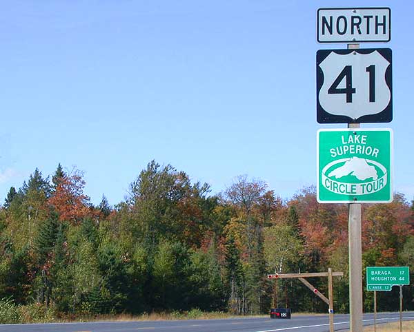
Main article: U.S. Route 41 in Michigan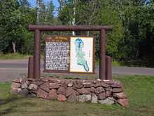 A sign in Copper Harbor denotes the point at which US 41 begins.
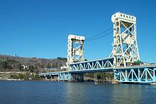 The Portage Lake Lift Bridge carries US 41/M-26 across the Keweenaw Waterway from Houghton to Hancock
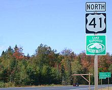
In the U.S. state of Michigan, US 41 is a state trunkline highway that enters the state via the Interstate Bridge between Marinette, Wisconsin and Menominee, Michigan. Along its 279.167-mile (449.276 km) route,[5] US 41 serves as a major conduit for Michigan traffic.[6] The route from the southern terminus to downtown Houghton is part of the National Highway System.[7] The trunkline comprises mostly two lanes, undivided except for sections that are concurrent with US 2 near Escanaba or M-28 near Marquette. US 41/M-28 is a four-lane expressway along the "Marquette Bypass", and segments of the highway in Delta and Marquette counties have four lanes.[8] and the Copper Country Trail National Scenic Byway. The trunkline ends at a cul-de-sac east of Fort Wilkins State Park in Copper Harbor, serving the Central Upper Peninsula and Copper Country.[8][9]
Along the route, US 41 passes through farm fields, forest lands, and along the Lake Superior shoreline. The highway is included in the Lake Superior Circle Tour and the Lake Michigan Circle Tour.[8] It also passes through the Hiawatha National Forest and the Keweenaw National Historical Park.[10] Historical landmarks along the trunkline include the Marquette Branch Prison, Peshekee River Bridge and the Quincy Mine.[11][12]
History
See also: Tamiami TrailWhen their routes were originally laid out in 1926, U.S. 41's southern endpoint was in Naples, Florida, at the western endpoint of U.S. 94, which ran east to Miami. In 1949, U.S. 94 was decommissioned, and the entire route became part of U.S. 41, giving it an east–west section that retained the hidden SR 90 designation. The former US 94 ended in Miami at the same intersection where U.S. 41 (and SR 90) do now. In 1953, U.S. 41 was extended along US 1 and State Road A1A to terminate in Miami Beach, Florida, but it was truncated back to the earlier terminus in 2000.
Prior to 1993, when the Florida Department of Transportation color-coded U.S. highways in Florida, the color used for U.S. 41 was orange.
US 41 initially took a more westerly route between Nashville, Tennessee and Hopkinsville, Kentucky. The current U.S. 41 was U.S. Route 241. In 1930, the two routes became U.S. Routes 41W and 41E, but in 1943 the western route became U.S. Route 41 Alternate, with the main U.S. 41 moving to the east route.
In July 2005, efforts started in Congress to re-designate U.S. 41 between Milwaukee and Green Bay, Wisconsin as Interstate 41. The new Interstate would also include U.S. Route 45 between current U.S. 41 and the intersection with Interstate 94 and Interstate 894. It is believed that U.S. 41 at that time would then be re-routed to remain concurrent with I-41.
Major intersections
 US 41 in Baraga County, Michigan
- Interstate 95 in Miami, Florida
- State Road 826 in West Miami, Florida
- State Road 821 (the Homestead Extension of Florida's Turnpike) near Sweetwater, Florida
- Interstate 275 north of Bradenton, Florida
- Interstate 4 in eastern Tampa, Florida
- Interstate 275 in northern Tampa, Florida
- Interstate 75 14 miles (23 km) south of Lake City, Florida
- Interstate 10 4 miles (6.4 km) north of Lake City, Florida
- Interstate 440 Pkwy (Tennessee) 7.64 miles (12.30 km) south of Nashville, Tennessee
- Interstate 75 north of Tifton, Georgia
- Interstate 75 in Unadilla, Georgia
- Interstate 75 5 miles (8.0 km) north of Unadilla, Georgia
- Interstate 75 in Perry, Georgia
- Interstate 75 in Macon, Georgia
- Interstate 475 (Georgia) 14 miles (23 km) northwest of Macon, Georgia
- Interstate 75 in Forest Park, Georgia
- Interstate 285 in southern Forest Park, Georgia
- Interstate 75 three times in Atlanta, Georgia
- Interstate 85 in southern Atlanta (Hapeville)
- Langford Parkway in Atlanta, Georgia – indirect
- Interstate 20 in Atlanta
- Interstate 75 north of Calhoun, Georgia
- Interstate 75 in Rocky Face, Georgia
- Interstate 75 in Ringgold, Georgia
- Interstate 75 in Chattanooga, Tennessee
- Interstate 24 three times in Chattanooga, Tennessee
- Interstate 24 3 miles (4.8 km) south of Manchester, Tennessee
- Interstate 24 6 miles (9.7 km) northwest of Manchester, Tennessee
- State Route 840 south of Smyrna, Tennessee
- Interstate 24 twice in Nashville, Tennessee
- Interstate 65 twice in Nashville
- Edward T. Breathitt Pennyrile Parkway in Hopkinsville, Kentucky and Madisonville, Kentucky
- Wendell H. Ford Western Kentucky Parkway near Madisonville, Kentucky
- Interstate 64 14 miles (23 km) north of Evansville, Indiana
- U.S. Route 50 at Vincennes, Indiana
- Interstate 70 in Terre Haute, Indiana
- Interstate 74 in Veedersburg, Indiana
- U.S. Route 24/U.S. Route 52 in Kentland, Indiana
- U.S. Route 30 in Schererville, Indiana
- Interstate 80/Interstate 94 in Hammond, Indiana
- Interstate 90 in Hammond, Indiana
- Indiana State Route 912 in Hammond, Indiana
- Interstate 90 in southeastern Chicago, Illinois
- At the terminus of Interstate 55 south of downtown Chicago
- Interstate 94 in Wilmette, Illinois (concurrent for 5 miles (8.0 km) to Highland Park, Illinois)
- Interstate 94 near the Wisconsin/Illinois border (concurrent through Milwaukee, Wisconsin)
- Wisconsin Highway 23 in Fond du Lac, Wisconsin
- U.S. Route 45 in northwestern Milwaukee, Wisconsin and Oshkosh, Wisconsin
- U.S. Route 10 in Menasha, Wisconsin
- Wisconsin Highway 441 (also known as the Tri-County Expressway) in Menasha, Wisconsin
- Wisconsin Highway 441 in Appleton, Wisconsin
- Wisconsin Highway 172 in Green Bay, Wisconsin
- Wisconsin Highway 29 in Green Bay, Wisconsin
- Interstate 43 in northern Green Bay, Wisconsin
- U.S. Route 141 in Abrams, Wisconsin
In popular culture
- US 41 is referenced in the The Allman Brothers Band song "Ramblin' Man", the singer claiming to have been born "in the back seat of a Greyhound bus" traveling this highway.
- Tom Petty & the Heartbreakers' 2010 album Mojo has a song called "US 41," which is appropriate since the band is originally from Florida.
- US 41 is referenced in the Alan Jackson song "I Don't Even Know Your Name", sitting in a fictitious roadhouse
Related routes
See also: Bannered routes of U.S. Route 41- U.S. Route 141
- U.S. Route 241 (defunct)
- U.S. Route 341
- U.S. Route 441
- U.S. Route 541 (defunct)
- U.S. Route 641
References
- ^ a b Droz, Robert V. U.S. Highways : From US 1 to (US 830). URL accessed 22:46, 20 February 2006 (UTC).
- ^ Estimated distance via Rand McNally 2004 U.S. Road Atlas.
- ^ http://en.wikipedia.org/wiki/Hammond,_Indiana
- ^ http://en.wikipedia.org/wiki/List_of_cities_in_Indiana
- ^ Michigan Department of Transportation (2001). Control Section/Physical Reference Atlas (Map). http://mdotwas1.mdot.state.mi.us/public/maps/pr/. Retrieved January 25, 2008.
- ^ "US 41/M-28 Access Management Plan, Chapter One" (PDF). Michigan Department of Transportation. April 28, 2004. Archived from the original on December 23, 2007. http://web.archive.org/web/20071223031233/http://www.michigan.gov/documents/MDOT_US-41_M28_chapter1_108596_7.pdf. Retrieved January 18, 2008.
- ^ Michigan Department of Transportation (April 23, 2006) (PDF). National Highway System, Michigan (Map). http://www.michigan.gov/documents/MDOT_NHS_Statewide_150626_7.pdf. Retrieved February 4, 2008.
- ^ a b c Michigan Department of Transportation (2007). Official 2007 Department of Transportation Map (Map). 1 in:15 mi/1 cm:9 km. http://www.michigan.gov/mdot/0,1607,7-151-9622_11033_11151---,00.html.
- ^ Google, Inc. Google Maps – Copper Harbor, Grant, MI (Map). Cartography by Google, Inc. http://maps.google.com/maps?f=q&hl=en&geocode=&q=Copper+Harbor,+Grant,+MI&ie=UTF8&ll=47.466484,-87.882686&spn=0.018451,0.044975&z=15. Retrieved August 29, 2008.
- ^ Rand McNally. The Road Atlas: Michigan (Map). 1 in:20 mi (2008 ed.). p. 50. ISBN 0-528-93981-5. http://go.randmcnally.com/MI.
- ^ "National Register of Historic Places — Michigan (MI), Marquette County". National Register of Historic Places. 1999. http://www.nationalregisterofhistoricplaces.com/MI/Marquette/state.html. Retrieved February 12, 2008.
- ^ "National Register of Historic Places — Michigan (MI), Houghton County". National Register of Historic Places. 1999. http://www.nationalregisterofhistoricplaces.com/MI/Houghton/state.html. Retrieved September 3, 2008.
- Endpoints of U.S. highways: U.S. Highway 41 and U.S. Highway 94
External links
 Main U.S. Routes
1 2 3 4 5 6 7 8 9 10 11 12 13 14 15 16 17 18 19 20 21 22 23 24 25 26 27 28 29 30 31 32 33 34 35 36 37 38 40 41 42 43 44 45 46 48 49 50 51 52 53 54 55 56 57 58 59 60 61 62 63 64 65 66 67 68 69 70 71 72 73 74 75 76 77 78 79 80 81 82 83 84 85 87 89 90 91 92 93 94 95 96 97 98 99 101 163 400 412 425 Lists U.S. Routes • Bannered • Divided • Bypassed Browse numbered routes ←  SR 40
SR 40FL SR 41  →
→←  SR 40
SR 40GA SR 41  →
→←  SR-40
SR-40TN SR-41  →
→←  KY 40
KY 40KY US 42  →
→←  US 40
US 40IN SR 42  →
→←  IL 40
IL 40IL IL 41  →
→←  WIS 40
WI WIS 41  →
→←  M-40
M-40MI M-41  →Categories:
- U.S. Highway System
- U.S. Route 41
- U.S. Highways in Florida
- U.S. Highways in Miami-Dade County, Florida
- U.S. Highways in Michigan
- U.S. Highways in Wisconsin
- U.S. Highways in Indiana
- U.S. Highways in Kentucky
- U.S. Highways in Tennessee
- U.S. Highways in Georgia (U.S. state)
- Dixie Highway
- U.S. Route 2


Wikimedia Foundation. 2010.