- Carnac stones
-
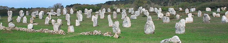
 The Ménec alignments, the most well-known megalithic site amongst the Carnac stones.
 Stones in the Kerlescan alignments
The Carnac stones are an exceptionally dense collection of megalithic sites around the French village of Carnac, in Brittany, consisting of alignments, dolmens, tumuli and single menhirs. The more than 3,000 prehistoric standing stones were hewn from local rock and erected by the pre-Celtic people of Brittany, and are the largest such collection in the world.[1] Local tradition claims that the reason they stand in such perfectly straight lines is that they are a Roman legion turned to stone by Merlin or Saint Cornelius – Brittany has its own local versions of the Arthurian cycle. A Christian legend associated with the stones held that they were pagan soldiers in pursuit of Pope Cornelius when he turned them to stone.[2][3][4]
Most of the stones are within the Breton village of Carnac, but some to the east are within La Trinité-sur-Mer. The stones were erected at some stage during the Neolithic period, probably around 3300 BC, but some may date to as old as 4500 BC.[5] In recent centuries, many of the sites have been neglected, with reports of dolmens being used as sheep shelters, chicken sheds or even ovens.[6] Even more commonly, stones have been removed to make way for roads, or as building materials. The continuing management of the sites remains a controversial topic.[1][7]
Contents
Alignments
There are three major groups of stone rows — Ménec, Kermario and Kerlescan — which may have once formed a single group, but have been split up as stones were removed for other purposes.[8]
 Ménec alignment
Ménec alignments
 Stones in the Ménec alignment
Eleven converging rows of menhirs stretching for 1,165 by 100 metres (3,822 by 330 ft). There is what Alexander Thom considered to be the remains of stone circles at either end. According to the tourist office there is a "cromlech containing 71 stone blocks" at the western end and a very ruined cromlech at the eastern end. The largest stones, around 4 metres (13 ft) high, are at the wider, western end; the stones then become as small as 0.6 metres (2 ft 0 in) high along the length of the alignment before growing in height again toward the extreme eastern end.
Kermario (“House of the Dead″)[9] alignment
 Kermario alignment
 Stones in the Kermario alignment
This fan-like layout recurs a little further along to the east in the Kermario alignment. It consists of 1029 stones[10] in ten columns, about 1,300 m (4,300 ft) in length.[8] A stone circle to the east end, where the stones are shorter, was revealed by aerial photography.[11]
Kerlescan alignments
 Kerlescan alignment
A smaller group of 555 stones, further to the east of the other two sites. It is composed of 13 lines with a total length of about 800 metres (2,600 ft),[8] ranging in height from 80 cm (2 ft 7 in) to 4 m (13 ft).[12] At the extreme west, where the stones are tallest, there is a stone circle which has 39 stones. There may also be another stone circle to the north.[13]
Petit-Ménec alignments
A much smaller group, further east again of Kerlescan, falling within the commune of La Trinité-sur-Mer. These are now set in woods, and most are covered with moss and ivy.[14]
Tumuli
There are several tumuli, mounds of earth built up over a grave. In this area, they generally feature a passage leading to a central chamber which once held neolithic artefacts.
 Tumulus of Saint-Michael
- Saint-Michael
- The tumulus of Saint-Michael was constructed between 5000 BC and 3400 BC. At its base it is 125 by 60 m (410 by 200 ft), and is 12 m (39 ft) high. It required 35,000 cubic metres (46,000 cu yd) of stone and earth. Its function was the same as that of the pyramids of Egypt: a tomb for the members of the ruling class. It contained various funerary objects, such as 15 stone chests, pottery, jewellery, most of which are currently held by the Museum of Prehistory of Carnac.[15] It was excavated in 1862 by René Galles with a series of vertical pits, digging down 8 m (26 ft). Le Rouzic also excavated it between 1900 and 1907 discovering the tomb and the stone chests.[16]
- A chapel was built on top in 1663 but was rebuilt in 1813, before being destroyed in 1923. The current building is an identical reconstruction of the 1663 chapel, built in 1926.
Also known as Er Mané, it is a chamber tomb 85 m (279 ft) long, 35 m (115 ft) wide, and 5 m (16 ft) high. It has a dolmen at the west end, and two tombs at the east end.[15] A small menhir, approximately 3 m (10 ft) high, is nearby.
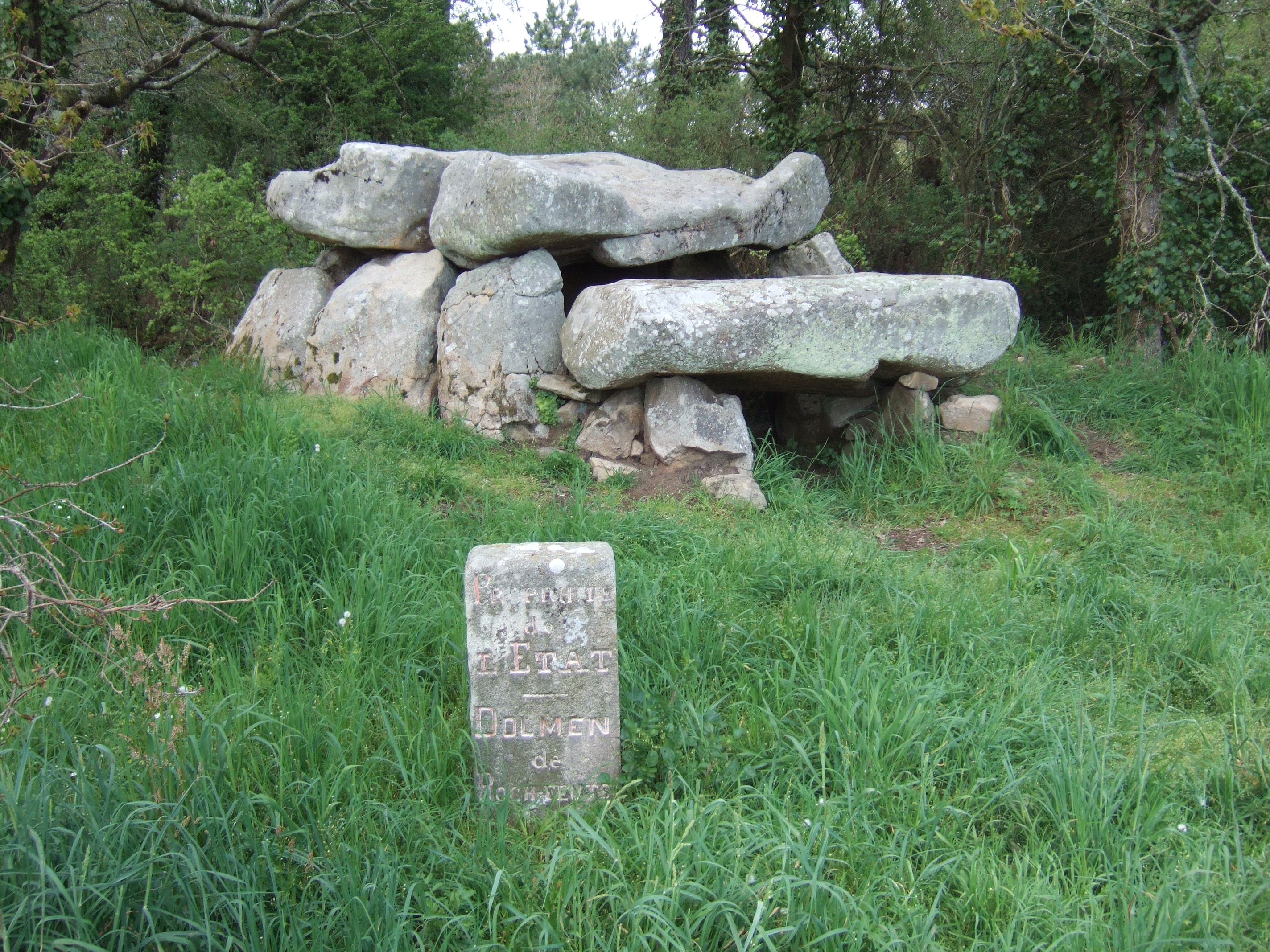
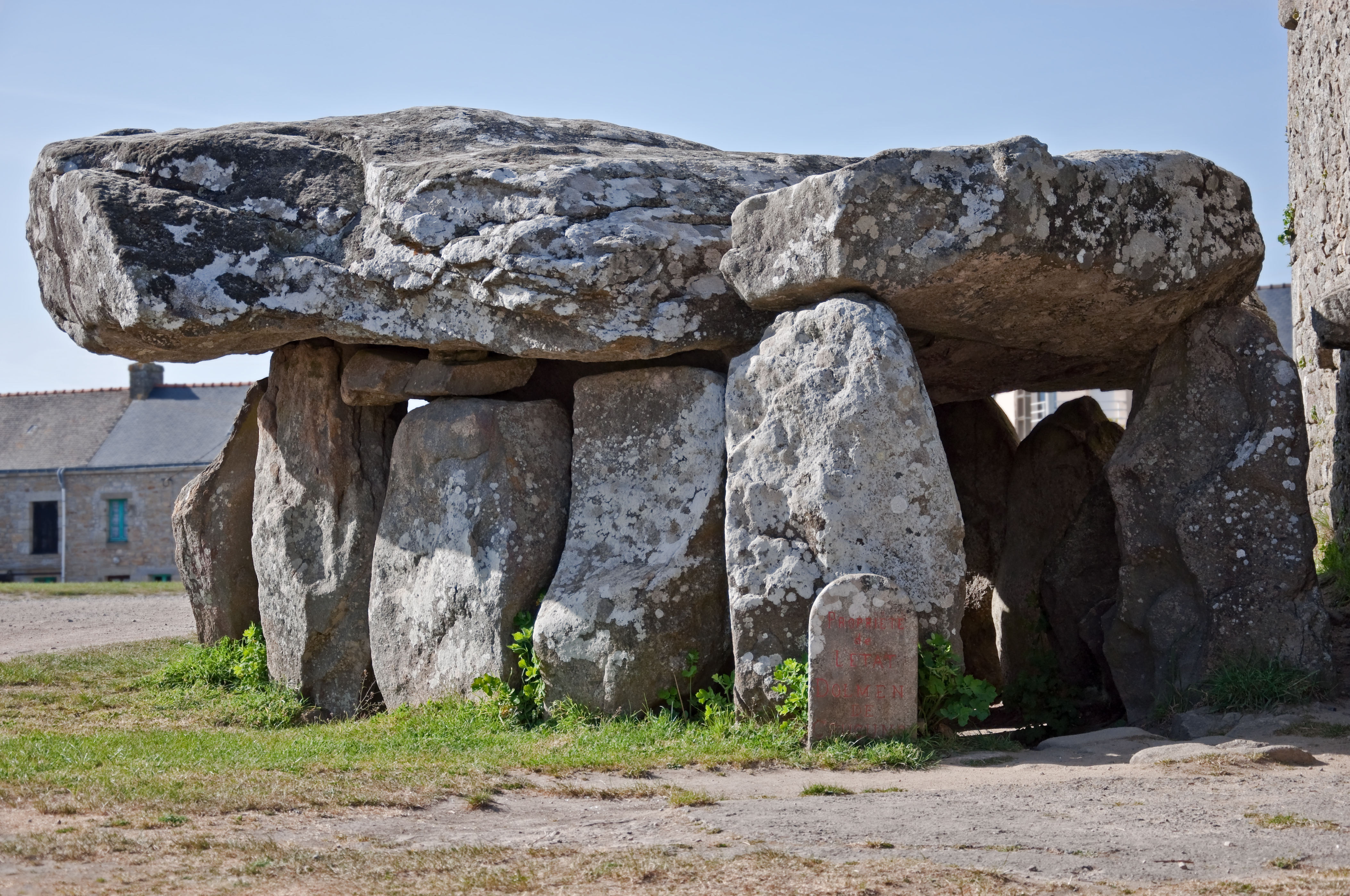
Dolmens
 The dolmen Er-Roc'h-Feutet. An inscription next to every standing stone formation proclaims ownership by the state of France.
 The Crucuno dolmen
There are several dolmens scattered around the area. These dolmens are generally considered to have been tombs, however the acidic soil of Brittany has eroded away the bones. They were constructed with several large stones supporting a capstone, then buried under a mound of earth. In many cases, the mound is no longer present, sometimes due to archeological excavation, and only the large stones remain, in various states of ruin.
- Er-Roc'h-Feutet
- North, near the Chapelle de La Madelaine. Has a completely covered roof.
- La Madelaine 47°37′15″N 3°02′54″W / 47.6208°N 3.0482°W[18]
- A large dolmen measuring 12 by 5 m (39 by 16 ft), with a 5 m (16 ft) long broken capstone.[6] It is named after the nearby Chapelle de La Madelaine, which is still used.
- Kercado
- A rare dolmen still covered by its original cairn. South of the Kermario alignments, it is 25 to 30 metres (82–98 ft) wide, 5 m (16 ft) high, and has a small menhir on top. Previously surrounded by a circle of small menhirs 4 m (13 ft) out,[16] the main passage is 6.5 m (21 ft) long and leads to a large chamber where numerous artifacts were found, including axes, pearls, arrow heads and pottery. It was constructed around 4600 BC and used for approximately 3,000 years.[16]
- Mané Brizil
- Kerlescan
- A roughly rectangular mound, with only one capstone remaining. It is aligned east-to-west, with a passage entrance to the south.[13]
- Kermarquer
- On a small hill, has two separate chambers.
- Mané-Kerioned (Pixies' mound or Grotte de Grionnec[16])
- A group of three dolmens with layout unique in Brittany,[16] once covered by a tumulus. Whereas most groups of dolmens are parallel, these are arranged in a horse shoe. The largest of the three is at the east, 11 metres (36 ft).[15]
- Crucuno
- A "classic" dolmen, with a 40-tonne (44-short-ton), 7.6-metre (24 ft 11 in) tablestone resting on pillars roughly 1.8 m (5 ft 11 in) high. Prior to 1900, it was connected by a passage making it 24 m (79 ft) long.[16]
- Crucuno stone rectangle 47°37′30″N 3°07′18″W / 47.625°N 3.121667°W
- A classic 3, 4, 5 rectangle of 21 menhirs varying in height from 0.91 metres (3.0 ft) to 2.4 metres (7.9 ft) that is aligned along its diagonal to the midsummer sunrise. Alexander Thom suggested it measured forty by thirty of his megalithic yards.[19]
Other formations
 The Manio quadrilateral arrangement.
 The Manio "Giant".
There are some individual menhirs and at least one other formation which do not fit into the above categories.
- Manio quadrilateral
- An arrangement of stones to form the perimeter of a large rectangle. Originally a "tertre tumulus" with a central mound, it is 37 metres (121 ft) long, and aligned to east of northeast. The quadrilateral is 10 m (33 ft) wide to the east, but only 7 metres (23 ft) wide at the west.[20]
- Manio giant 47°36′12″N 3°03′22″W / 47.6034°N 3.056°W[21]
Near the quadrilateral is a single massive menhir, now known as the "Giant". Over 6.5 m (21 ft) tall, it was re-erected around 1900 by Zacharie Le Rouzic,[16] and overlooks the nearby Kerlescan alignment.[22]
Excavation and analysis
 Large upright in the Ménec alignment
From the 1720s various people showed increasing interest in these features.[23] In 1796, for example, La Tour d'Auvergne attributed them to druidic gatherings.[16] In 1805, A. Maudet de Penhoët claimed they represented stars in the sky.[16] However, there still is a somewhat surprising lack of research done on the origins or purpose of the stones.
Miln and Le Rouzic
The first extensive excavation was performed in the 1860s by Scottish antiquary James Miln (1819–1881), who reported that fewer than 700 of the 3,000 stones were still standing.[24] Towards 1875, Miln engaged a local boy, Zacharie Le Rouzic (1864–1939), as his assistant, and Zacharie learnt archaeology on the job. After Miln's death, he left the results of his excavations to the town of Carnac, and the James Miln Museum was established there by his brother Robert to house the artefacts. Zacharie became the director of the Museum and, although self-taught, became an internationally recognised expert on megaliths in the region. He too left the results of his work to the town, and the museum is now named Le Musée de Préhistoire James Miln – Zacharie le Rouzic.[25][26]
Other theories
 The Ménec alignments of some 1,100 stones in 11 columns.
In 1887, H. de Cleuziou argued for a connection between the rows of stones and the directions of sunsets at the solstices.[16]
Among more recent studies, Alexander Thom worked with his son Archie from 1970 to 1974 to carry out a detailed survey of the Carnac alignments, and produced a series of papers on the astronomical alignments of the stones as well as statistical analysis supporting his concept of the megalithic yard.[25][27]
Studies by Pierre Méreaux, who spent 30 years researching the stones in field studies, are well known.[28] He generally rejects the "cult of the dead", arguing that the dolmens were instead perhaps used as primitive seismic instruments, Brittany being the most seismically-active area of France.[29] In particular, he argues controversially that Brittany would have been even more seismically active back then, due to the influx of water with the retreating ice. He also posits correlations between the location and orientation of menhirs, and those of seismic fault lines. He also goes so far as to claim that the balancing of large stones on delicate points would act as an effective earthquake detector: "the heavy tables of these monuments with their dizzying overhangs must have devilishly balanced on their three feet, at the slightest shock. As an earthquake observation station, we could not do better today."[30]
There are also general theories on the use of the stones as astronomical observatories, as has been claimed for Stonehenge. According to one such theory, the massive menhir at nearby Locmariaquer was linked to the alignments for such a purpose.[12]
Management
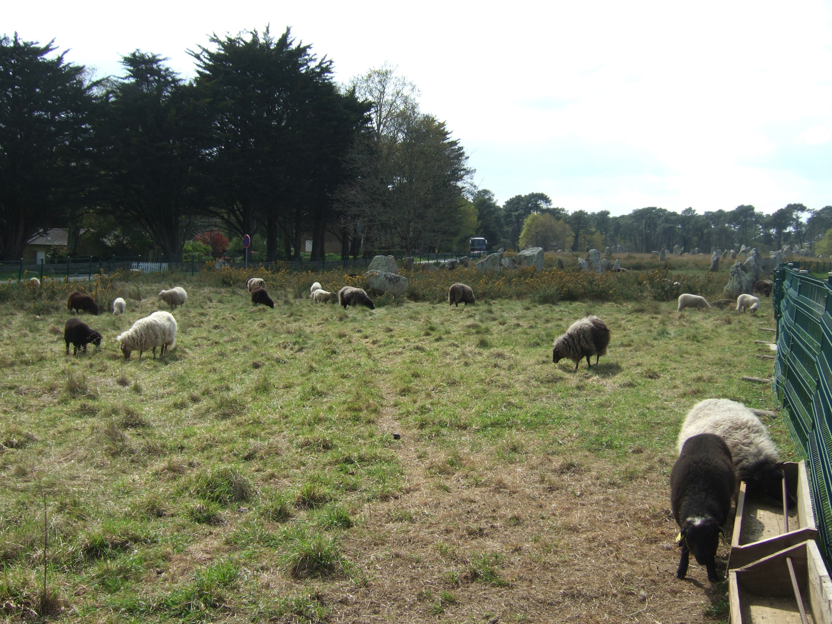
 Sheep grazing around the Kerlescan alignment, part of a new management strategy.
The Musée de Préhistoire James Miln – Zacharie le Rouzic is at the centre of conserving and displaying the artefacts from the area.[26] It also contains the "world's largest collection [of] prehistoric[al] exhibits"[15] with over 6,600 prehistoric objects from 136 different sites.
The monuments themselves were listed and purchased by the State at the start of the 20th century to protect them against quarrymen, and while this was successful at the time, in the mid century redevelopment, changes to agricultural practices and increasing tourism bringing visitors to the stones led to rapid deterioration. The Ministère de la Culture et de la Communication (Heritage Ministry) re-examined the issue from 1984, and subsequently set up the ‘Mission Carnac’ 1991 with the aim of rehabilitating and developing the alignments. This involved restricting public access, launching a series of scientific and technical studies, and producing a plan for conservation and development in the area.[31]
As with the megalithic structure of Stonehenge in England, management of the stones can be controversial. Since 1991, the main groups of stone rows have been protected from the public by fences "to help vegetation growth",[15] preventing visits except by organised tours. They are open during Winter, however.[32] When James Miln studied the stones in the 1860s, he reported that fewer than 700 of the 3,000 stones were still standing, and subsequent work during the 1930s and 1980s (using bulldozers) rearranged the stones, re-erecting some, to make way for roads or other structures. In 2002, protesters invaded the site, opening the padlocks and allowing tourists free entry.[24] In particular, the group Collectif Holl a gevred (French and Breton for "the everyone-together collective") occupied the visitor centre for the Kermario alignment, demanding an immediate stop to current management plans and local input into further plans.[33]
In recent years, management of the site has also experimented with allowing sheep to graze amongst the stones, in order to keep gorse and other weeds under control.[34]
See also
- Prehistory of Brittany
- Standing stones
- Dolmen
- Tumulus
- Passage grave
- Stone row
- European Megalithic Culture
- List of megalithic sites
References
Bibliography
- A Guide to the Stone Circles of Britain, Ireland and Brittany Aubrey Burl, Yale University Press 1995, ISBN 0-300-06331-8
- Carnac: Guide pratique 2006 (provided by Carnac tourist office)
- “The megaliths of Brittany” by Jacques Briard, translated by Juan-Paolo Perre, © 1997-2007, Éditions Gisserot
- Des Pierres Pour Les Vivants by Pierre Méreaux, Kerwangwenn - 29540 Spezet, Bretagne, Nature & Bretagne (1992 edition), 244 pages
- From Carnac to Callanish: the prehistoric stone rows and avenues of Britain, Ireland and Brittany Aubrey Burl, Yale University Press, ISBN 0-300-05575-7, 1993
- "Standing Stones - M E g A L i T h i A - Books about megalithic sites (UK version)". M E g A L i T h i A. 2005-07-17. http://www.megalithia.com/bibliographyuk.html#carn2call. Retrieved 2009-07-25.
- Mason, Paul (15 March 2008). The Mystery of Stone Circles. Heinemann-Raintree. ISBN 9781432910235. http://books.google.com/books?id=uCvibkN1SC0C. Retrieved 25 February 2010.
Notes
- ^ a b "Megaliths of Carnac: Introduction". menhirs.tripod.com. http://menhirs.tripod.com/intro.html. Retrieved 2010-01-07.
- ^ "TheRecord.com - Travel - Marvelling at Carnac's stones". News.therecord.com. 2008-03-08. http://news.therecord.com/Life/Travel/article/320293. Retrieved 2009-05-05.
- ^ "France Holidays, Brittany". Franceholidays.co.uk. http://www.franceholidays.co.uk/france_holidays/brittany.php. Retrieved 2009-05-05.
- ^ "Why are Carnac Stones Called Megaliths?". www.bigsiteofamazingfacts.com. http://www.bigsiteofamazingfacts.com/why-are-carnac-stones-called-megaliths. Retrieved 2010-01-07.
- ^ "Carnac Stones, Brittany". Sacred Destinations Travel Guide. http://www.sacred-destinations.com/france/carnac-stones.htm. Retrieved 2006-05-17.
- ^ a b TheCaptain (3 January 2005). "La Madeleine dolmen Burial Chamber (Dolmen)". The Megalithic Portal and Megalith Map. http://www.megalithic.co.uk/article.php?sid=9178. Retrieved 2006-05-17.
- ^ "Megaliths of Carnac: Standing Stones / Menhirs". megaliths.sherwoodonline.de. http://megaliths.sherwoodonline.de/menhir.html. Retrieved 2010-01-07.
- ^ a b c Leonard, R. Cedric (1 May 2006). "The Stones of Carnac". http://www.atlantisquest.com/Carnac.html. Retrieved 2006-05-17.
- ^ "Mané Kermario". http://myweb.tiscali.co.uk/celynog/Brittany/mane_kermario.htm. Retrieved 2006-05-17.
- ^ Holidays in Brittany
- ^ "Kermario". Myweb.tiscali.co.uk. http://myweb.tiscali.co.uk/celynog/Brittany/kermario.htm. Retrieved 2009-05-05.
- ^ a b (French) http://www.dinosoria.com/dolmen_menhir.htm
- ^ a b "Kerlescan". Myweb.tiscali.co.uk. http://myweb.tiscali.co.uk/celynog/Brittany/kerlescan.htm. Retrieved 2009-05-05.
- ^ "Petit Ménec". Myweb.tiscali.co.uk. http://myweb.tiscali.co.uk/celynog/Brittany/petit_menec.htm. Retrieved 2009-05-05.
- ^ a b c d e "Office de Tourisme de Carnac". Web.archive.org. 2006-07-03. Archived from the original on 2006-07-03. http://web.archive.org/web/20060703063525/http://www.ot-carnac.fr/version_anglaise/histoire_alignement.php. Retrieved 2009-07-25.
- ^ a b c d e f g h i j Annick Jacq. "Carnac". Bretagne-celtic.com. http://www.bretagne-celtic.com/carte_carnac.htm. Retrieved 2009-05-05.
- ^ "The Megalithic Portal and Megalith Map: Moustoir tumulus Moustoir Er Mané] Chambered Tomb]". Megalithic.co.uk. http://www.megalithic.co.uk/article.php?sid=9182. Retrieved 2009-06-23.
- ^ "The Megalithic Portal and Megalith Map: La Madeleine (Carnac) Burial Chamber (Dolmen)". Megalithic.co.uk. http://www.megalithic.co.uk/article.php?sid=9178. Retrieved 2009-05-05.
- ^ Alexander Thom; Archibald Stevenson Thom (1978). Megalithic remains in Britain and Brittany. Oxford University Press US. ISBN 9780198581567. http://books.google.com/books?id=WbTeKi00QH0C. Retrieved 30 April 2011.
- ^ "Manio Quadrilateral". Myweb.tiscali.co.uk. http://myweb.tiscali.co.uk/celynog/Brittany/manio_quadrilateral.htm. Retrieved 2009-05-05.
- ^ "The Megalithic Portal and Megalith Map: Geant du Manio Le Manio] Standing Stone (Menhir)]". Megalithic.co.uk. http://www.megalithic.co.uk/article.php?sid=9143. Retrieved 2009-06-23.
- ^ "Géant de Manio". Myweb.tiscali.co.uk. http://myweb.tiscali.co.uk/celynog/Brittany/geant_de_manio.htm. Retrieved 2009-05-05.
- ^ Astonishing Heaps of Stones
- ^ a b The Independent: Bretons fight for Carnac to stay in the Stone Age
- ^ a b Carnac — Megalithic alignments of standing stones.
- ^ a b Musée de Préhistoire James Miln – Zacharie le Rouzic
- ^ Wood, John Edwin (1978). Sun, Moon and Standing Stones (paperback 1980 ed.). Oxford: Oxford University Press. ISBN 0-19-285089-X.
- ^ Carnac, Stones for the Living: A Megalithic Seismograph? (Roslyn Strong): partial translation of Méreaux's "Des Pierres Pour Les Vivants". Also published in New England Antiquities Research Association Journal, Volume XXXV, Number 2, Winter 2001
- ^ CARNAC: Des Pierres Pour Les Vivants by Pierre Méreaux, Kerwangwenn — 29540 Spezet, Bretagne, Nature & Bretagne (1992 edition), cited by Roslyn Strong
- ^ Méreaux p60, cited and translated by Strong
- ^ The Carnac Project
- ^ "Carnac". Myweb.tiscali.co.uk. http://myweb.tiscali.co.uk/celynog/Brittany/carnac.htm. Retrieved 2009-05-05.
- ^ (French) http://nopasaran.samizdat.net/article.php3?id_article=662
- ^ "Menec West". Myweb.tiscali.co.uk. http://myweb.tiscali.co.uk/celynog/Brittany/menec_west.htm. Retrieved 2009-05-05.
External links
- (French) Carnac official website
- (French) Official website of Prehistory Museum of Carnac
- Carnac at france-for-visitors.com (includes map)
- Carnac, Stones for the Living: A Megalithic Seismograph? (Roslyn Strong): partial translation of Méreaux's "Des Pierres Pour Les Vivants".
- Online photo exhibition of the Carnac region's megaliths includes the giant menhir of Loqmariaquer, and marked and inscribed stones
- An amateur's guide to visiting the Carnac stones by car
- The megaliths of Carnac: Dolmen / passage graves — comprehensive list of dolmens in area with photos.
- The Megalithic Portal and Megalith Map — GPS coordinates of megalithic sites
- menhirslibres.org — website for a protest group.
Online maps
- http://members.tripod.com/Menhirs/dolmen.html — main sites in the Morbihan area
- http://www.bretagne-celtic.com/carte_carnac.htm — historical map
- http://www.megalithia.com/brittany/carnac/ — basic arrangement of the main alignments
Categories:- Archaeoastronomy
- Archaeological sites in Brittany
- Archaeological sites in France
- Megalithic monuments in France
- Stone Age Europe
- Buildings and structures in Morbihan
- Geography of Brittany


Wikimedia Foundation. 2010.