- Aigüestortes i Estany de Sant Maurici National Park
-
Aigüestortes i Estany de Sant Maurici National Park IUCN Category II (National Park)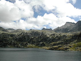
Lake Colomers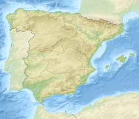

Nearest city Lleida Coordinates 42°35′13″N 0°58′28″E / 42.58694°N 0.97444°ECoordinates: 42°35′13″N 0°58′28″E / 42.58694°N 0.97444°E Area 141 km2 (54 sq mi) Established 1955 Governing body Spanish Ministry of Environment. managed: Catalan Department of Agriculture, Livestock, Fisheries, Food, and the Environment Aigüestortes i Estany de Sant Maurici National Park (Catalan: Parc Nacional d'Aigüestortes i Estany de Sant Maurici, Spanish: Parque Nacional de Aigüestortes y Lago de San Mauricio) is one of the fourteen Spanish National Parks, the second in the Pyrenees and the only one in Catalonia.
A wild mountain region in the Pyrenees, with peaks rising to 3,017 m (Besiberri Sud) and with nearly 200 lakes, many of them of glacial origin, the park comprises a core area of 141 km² and a buffer zone of 267 km² surrounding the park.
The park has an elevation range from 1,600 to 3,000 metres and contains four major vegetation zones: lower montane, upper montane, subalpine and alpine. It has a great variety of alpine vegetation, including dark-coniferous mountain forest (fir, mountain pine) and subalpine pine forest.
The fauna includes Pyrenean chamois, marmot, ermine, roe deer, among other mammals and numerous birds (Black Woodpecker, Common Crossbill, Lammergeier, Golden Eagle).
The park was created in 1955 after Ordesa y Monte Perdido National Park, first spanish National Park in the Pyrenees in 1918. Its administrative seats are in Espot and Boí. The park is mainly located in the comarques of Pallars Sobirà and Alta Ribagorça.
Contents
Situation
The National Park has 40,852 ha. divided in two different levels of protection: the core area and the buffer zone surrounding the park. This buffer zone creates a gradation from the inner side, more strictly protected to the external parts of the park. The core area is located in the comarques of Pallars Sobirà and Alta Ribagorça, and includes the main entrances of the Park:
In the west side, from the village of Boí, there’s the Aigüestortes plain. Aigüestortes means “winding waters” and it’s a very flat place where the river flows slowly in meanders. This places, more or less common in the area, indicates the existence of and old lake, today absolutely full of sediments.
From the east, up to the village of Espot, we found Sant Maurici lake, one of the most famous of the region, from where you can see the spectacular twin peaks of the Encantats. This picture is one of the simbols of the Park and is the logo of the Park.
The peripherical area also includes part of the municipalities of Vielha e Mijaran and Naut Aran in the Val d'Aran; Vilaller and Vall de Boí in the Alta Ribagorça; La Torre de Cabdella in the Pallars Jussà; and Espot, Alt Àneu, Esterri d'Àneu, La Guingueta d'Àneu and Sort in the Pallars Sobirà.
In the buffer zone also we can find very beautiful places with great natural values, as the forest of la Mata de Valencia, Gerber and Cabanes valleys, Colomers and Saboredo valleys, the Besiberri valley, the lakes of Cabdella, Montardo peak and some else.
History
The human settlement of the Pyrenees begun as long the glaciers was melting. Inside the borders of the National Park, not any human population was stabilized. But recent archeological studies have been found signals of temporally settlements from 8,500 years ago, in the Neolithic Age.
The 19th century was the time with more population in the high Pyrenees. Then the pressure on the natural resources also was very strong, with an intense forestry, farming, and fishing industry all around.
At the beginning of the 20th century, begun the establishment of the hydro electrical power plants that leads to a great transformation of the landscape which reminded basically unaltered until then.
On the 21st October 1955 the National Park was created by a law, becoming the fifth Spanish national park. On 30th March 1988, the Catalonian government declared the National park, together with an additional buffer zone, according to the Catalan laws. From that date, the management of the wild protected areas depends on the autonomous government, and begins to increase the budget, the staff and more strictly rules.
Since then, forestry exploitation, fishing, camping and any exploitation of natural resources becomes forbidden. Only it’s allowed extensive cattle breeding and the operative hydroelectric uses. Traditional uses of natural resources which are compatible with the protection of the wilderness are only allowed in the buffer zone.
In 1996 the National Park was enlarged, to a total area of 14,119 hectares.
In 1997, after litigation between Catalan and Spanish laws, it’s accorded that autonomic regions can also take part in the management of the national parks. Then Aigüestortes returns to the Spanish national parks net.
Biology
The park has an elevation range from 1,600 to 3,000 metres and different orientation of the valleys. For that reason very different ecosystems can be found inside the park.
Vegetation
In the lower parts of the valleys, around 1,500m high, we expect to found typical European deciduous forests with Pubescens Oak "Quercus humilis", European Ash "Fraxinus excelsior", beech "Fagus sylvatica" or Common Hazel "Corylus avellana". But this places has been historically exploited for humans and usually are now occupied with grasslands, and shrubs communities dominated by Common Box "Buxus sempervirens" or secondary forests with Scots Pine "Pinus sylvestris".
From 1.500 m to beyond 2,000 m, it’s the place for Mountain Pine "Pinus uncinata" forest. In this places its also founded Alpenrose "Rhododendron ferrugineum" and blueberry "Vaccinium myrtillus" which prefers more fresh places. Heather "Calluna vulgaris” or Common Juniper "Juniperus communis" prefers more sunny and dry places. In the north faces, less than 2,000 m its important silver fir "Abies alba" forests. La Mata de Valencia is the Pyrenean biggest fir tree forest.
In the alpine meadows, up 2,300 m where trees cannot live, it’s possible to found different species of the alpine flora, as "Gentiana alpina" among others.
Approximately the 8% of the species of the park are Pyrenean endemisms in wide sense. Around 7% they are plants with boreo-alpine or artico-alpine distribution, most of them arrived at the Pyrenees during the last Ice Age. The most important group of the National Park flora belongs to the eurosiberian group, the typical species from central Europe.
Fauna
Fauna is not easy to see in the National Park. It’s about 200 species from Chordata phyllum living there. About 66% of them are birds. Some of the most important ones are capercaillie "Tetrao urogallus", Rock Ptarmigan "Lagopus muta”, Golden eagle "Aquila chrysaetos", Griffon Vulture "Gyps fulvus" or Bearded Vulture “Gypaetus barbatus". Also are possible to see Black Woodpecker "Dryocopus martius", Red-billed Chough "Pyrrhocorax pyrrhocorax", Wallcreeper "Tichodroma muraria", White-throated Dipper "Cinclus cinclus", Citril Finch “Serinus citrinella” among others.
Most representative mammals are Chamois "Rupicapra pyrenaica", Stoat “Mustela erminea", Alpine Marmot "Marmota marmota" (which is not autochthonous) or Fallow Deer “Dama dama” and Roe Deer “Capreolus capreolus” which are also introduced in the National park during the second half of the XX century.
Among the amphibians, Pyrenean Brook Salamander "Euproctus asper" it’s significant but not easy to see. The Common Frog "Rana temporaria" is more or less common. It’s necessary be aware with Vipera aspis "Vipera aspis", a reptilian with poisonous bite, but it never attacks without provocation.
In the waters, brown trout "Salmo trutta fario", the local trout, must shares the place with other introduced species.
Geology and climate
Aigüestortes National Park is an important item in the Pyrenean geology. The predominant rocks are granite and slate. They both are very old Paleozoic rocks. This material emerged from the sea in the Paleogene, during the Alpine orogeny, giving place to the Pyrenees.
After that, the successive quaternary glaciations covered these mountains with huge glaciers. The lakes, the waterfalls, the sharpened peaks, the vertiginous ridges and the U-shaped valleys are the footprints of the erosive action of those ancient glaciers, today absolutely disappeared (except for a little remaining ones in the central Pyrenees).
Today, water it’s the most important hit, with the meanders on the water meadows, and a great number of little lakes, rivers and waterfalls.
The climate in the Park it’s cold. The mean temperature its around 0 to 5 ºC. In the upper parts, during all the winter season temperatures hardly arrives to 0ºC. Rain it’s more or less usual. Mean annual precipitation goes from 900 to 1300 mm. Mostly snow in the mountains.
Management and information
44% of the territory is national propriety. Mostly of the eastern part of the park lands belongs to the Espot’s neighbourhood. Only 6% of the land has particular owners. Even so, exploitation of natural resources is forbidden in the strictly National Park.
Public use is one of the most important objectives for a national park and people have the right to visit it. Aigüestortes is a more or less open park. The walking access is wideness allowed.
Information center
The Park has different Information centers widely distributed in the area. Boí its one of the main centres of the Park. It has also a public library and an exhibition about the settlement of the Pyrenees and the adaptations to live in the mountains.
In the house of the Park at Espot also can find information available and it’s possible to visit an exhibition about the three leading things of the park: rock, water and life.
In Llessui is the Museum of the shepherds, where the exhibition shows the traditional life and works of the shepherds from this valley.
Senet has an Information center where explains the evolution in the relation between humans and animals: a history about competition, exploitation and good fellowship.
During summer months a little information center is open in Estany Gento, while a cable railway is working in this area, in the higher valley of Torre de Cabdella,. There are some explanations about the water and the national park.
From all these centers is possible to participate in different organized activities.
Tourism
Tourist activities are regulated. Walking access is free, but is forbidden the camping, to collect any rocks, plants, flowers and mushrooms; hunting and fishing It’s not allowed to enter by private cars. In Espot or Boí exists a public transportation service (taxis 4x4) which allows the visitors to go to the most emblematic places: Aigüestortes plain or Sant Maurici lake.
During summertime, at the Val d'Aran entrances are also a taxis service that allows a more easy way to the Colomers or Restanca shelters. At the Vall Fosca, the southern entrance of the Park, a cableway connects Sallente with estany Gento, where begin some nice day walks.
Trekking
Summertime is a good time for trekking. There are a lot of possibilities, but it’s necessary to know what some of the paths are difficult to find or requires some experience and to be in good form.
The transpyrenean path, GR-11 marked with red and white lines, cross the park from one side to other.
At the information points are hiking brochures available (also in English) where are very recommended and easy paths with some explanations. Some of them are:
- At Boí valley, from Llebreta Lake to Llong Lake, following Sant Nicolau River. In this path a footbridge allows the handicapped people with wheels-chair visit the meanders of the Aigüestortes plain.
- From Espot and the Sant Maurici Lake, an interesting path goes up to the waterfall and Ratera Lake. From this lake, in 15 minutes more, it’s possible to arrive to a panoramic place with the best views over the Sant Maurici Lake. A second option goes up to Amitges shelter where we can appreciate the high mountain feelings.
- From the parking place of Clot Gran, near the Bonaigua Pass, to Gerber valley and lakes.
- From Banhs de Tredòs, at the Val d'Aran, walk to Colomers shelter and a very spectacular tour with lakes.
- From Estany Gento walk to Tort Lake and arrive to the Colomina shelter or Saburó Lake.
A very interesting tour for several days
- Carros de foc. It’s a personal deal that completes a circular tour around some of the shelters that exist in this area. The competitive option (Sky runner) must be completed in less than 24 hours but it’s better to have at least four or five days in order to do it in a more normal way of hike.
Other mountain activities as rock climbing, alpinism, snowshoes or backcountry ski are also allowed (with some regulations) in the National Park. The mountain shelters, the only places where are allowed to spend a night into the park, are very good places to stay if you like to complete higher objectives.
BTT
Bicycle it’s only allowed on paved routes inside the park strictly protected (just to Sant Maurici Lake or Aigüestortes plain). Some routes are available in the peripheral area, most of them with medium or hard level.
- Pedals de Foc: is an organized route for BTT around the park (not inside) for several days and possibility of backpacking transfer.
Refuges
Trekkers can find up to 10 guarded refuges in the park and its peripherical area. These are open during four months (end of spring and summer). During the winter, every refuge has its own opening calendar (usually around Christmas and Easter). It's necessary to book them in advance[1]. The refuges are the following:
- Amitges[2]
- Colomers
- Colomina
- Ernest Mallafré
- Estany Llong
- Josep Mª Blanc
- Pla de la Font
- Restanca
- Saboredo
- Ventosa i Calvell[3]
Additionally, there are two unguarded but well-equipped refuges (Mataró and Besiberri).
Surroundings
Close to the park there is a rich architectural heritage, including the Catalan Romanesque churches of the Vall de Boí. UNESCO declared it a World Heritage Site in November 2000.[4] A good example is the Sant Climent de Taüll church.
Gallery
-

Refugi Colomina
-

Sant Maurici lake
-

Pond de Ratera
References
- ^ (Spanish) Central de reservas
- ^ REFUGI D'AMITGES
- ^ (Spanish) http://www.refugiventosa.com/
- ^ Catalan Romanesque Churches of the Vall de Boí - World Heritage website
External links
- Guide to Parks in the Catalonia Pyrenees.
- [1] Official site in catalan or spanish
- [2] official site, with some information in english
 National parks of Spain
National parks Aigüestortes i Estany de Sant Maurici · Atlantic Islands of Galicia · Archipiélago de Cabrera · Cabañeros · Caldera de Taburiente · Doñana · Garajonay · Monfragüe · Ordesa y Monte Perdido · Picos de Europa · Sierra Nevada · Tablas de Daimiel · Teide · TimanfayaProposed Aigüestortes i Estany de Sant MauriciNatural parks Alt Pirineu • Aiguamolls de l'Empordà • Cadí–Moixeró • Cap de Creus • Ebre Delta • Els Ports • Montgrí, the Medes Islands and Baix Ter • Montseny • Montserrat • Sant Llorenç de Munt and l'Obac • Serra de Montsant • Garrotxa Volcanic Zone • Garraf MassifNatural Site of National Interest L'Albera • Poblet • Massís del PedraforcaNatural reserve Llobregat DeltaMarine reserve Categories:- IUCN Category II
- Geography of Catalonia
- Protected areas of Catalonia
- National parks of Spain
- Pyrenees
- Protected areas established in 1956


Wikimedia Foundation. 2010.