- Chiltern (district)
-
Chiltern District — Non-metropolitan district — Chiltern shown within Buckinghamshire
Sovereign state United Kingdom Constituent country England Region South East England Non-metropolitan county Buckinghamshire Status Non-metropolitan district Admin HQ Amersham Incorporated 1 April 1974 Government - Type Non-metropolitan district council - Body Chiltern District Council - Leadership Leader & Cabinet (Conservative) - MPs Cheryl Gillan Area - Total 75.8 sq mi (196.35 km2) Area rank 168th (of 326) Population (2010 est.) - Total 91,400 - Rank 251st (of 326) - Density 1,205.6/sq mi (465.5/km2) - Ethnicity 92.9% White
3.6% S.Asian
1.1% Black
1.4% Mixed Race
1.0% Chinese or OtherTime zone GMT (UTC0) - Summer (DST) BST (UTC+1) ONS code 11UC OS grid reference SU965985 Website chiltern.gov.uk Chiltern is one of four local government districts of Buckinghamshire in south central England. It is named after the Chiltern Hills on which the region sits.
The main towns in the district are Amersham and Chesham. It was formed on 1 April 1974 by the merger of the Chesham Urban District and Amersham Rural District (which entirely surrounded it).
Contents
Parishes
The parishes that make up Chiltern District are:
- Amersham
- Ashley Green
- Chalfont St. Giles
- Chalfont St Peter
- Chartridge
- Chenies
- Chesham
- Chesham Bois
- Cholesbury-cum-St Leonards
- Coleshill
- Great Missenden
- Latimer
- Little Chalfont
- Little Missenden
- Penn
- Seer Green
- The Lee
See also the list of civil parishes in Buckinghamshire
Council affiliation
As of April 2011, it was as follows[1]
Party Number of councillors Conservative 28 Independent 1 Liberal Democrats 7 Transport
Along with the Aylesbury Vale district, Chiltern contains no motorways except for a very small section of the M25 in the south-eastern corner. The major roads through the district are the A413 and the A404, the two meeting in Amersham. Railways services are provided by Chiltern Railways and London Underground's Metropolitan line. The Great Central Main Line carried traffic between London and Manchester until 1966, the section to Aylesbury is all that remains, being termed the London to Aylesbury Line. The only major station in the district is Amersham. Chesham is served exclusively by the Underground - it is the furthest tube station out of central London.
Quality of Rural Life
In May 2008, the district was named by the Halifax bank as having the best rural quality of life anywhere in Britain.[2]
Law and Order
Police stations are situated in Amersham and Chesham. The Magistrates' Court in Amersham was closed in March 2010, and has since been reopened as a Crown Court.
Energy policy
In May 2006, a report commissioned by British Gas [3] showed that housing in Chiltern produced the 4th highest average carbon emissions in the country at 7,421 kg of carbon dioxide per dwelling.
References
- ^ https://isa.chiltern.gov.uk/democracy/mgMemberIndex.aspx?bcr=1
- ^ HBOS quality of life survey
- ^ British Gas news
External links
Ceremonial county of Buckinghamshire Buckinghamshire Portal Unitary authorities Boroughs or districts Major settlements Amersham · Aylesbury · Beaconsfield · Buckingham · Chesham · High Wycombe · Marlow · Milton Keynes (including Bletchley, Fenny Stratford, Stony Stratford, Wolverton) · Newport Pagnell · Olney · Princes Risborough · Wendover · Winslow · Woburn Sands
See also: List of civil parishes in BuckinghamshireRivers Topics Boundary changes · Grade I listed buildings · High Sheriff · History · Lord Lieutenant · Monastic houses · Museums · Parliamentary constituencies · Places · Places of interest · Railways · Schools (Bucks) · Schools (Milton Keynes) · Sites of Special Scientific Interest · Transport Districts of South East England
Berkshire 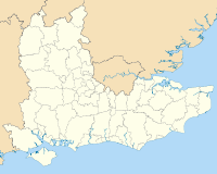
Buckinghamshire Aylesbury Vale • Chiltern • Milton Keynes • South Bucks • Wycombe
East Sussex Brighton & Hove • Eastbourne • Hastings • Lewes • Rother • Wealden
Hampshire Basingstoke and Deane • East Hampshire • Eastleigh • Fareham • Gosport • Hart • Havant • New Forest • Portsmouth • Rushmoor • Southampton • Test Valley • Winchester
Isle of Wight Kent Ashford • Canterbury • Dartford • Dover • Gravesham • Maidstone • Medway • Sevenoaks • Shepway • Swale • Thanet • Tonbridge and Malling • Tunbridge Wells
Oxfordshire Surrey Elmbridge • Epsom and Ewell • Guildford • Mole Valley • Reigate and Banstead • Runnymede • Spelthorne • Surrey Heath • Tandridge • Waverley • Woking •
West Sussex Adur • Arun • Chichester • Crawley • Horsham • Mid Sussex • Worthing
Categories:- Chiltern
- Local government in Buckinghamshire
- Non-metropolitan districts of Buckinghamshire
- Local government districts of South East England


Wikimedia Foundation. 2010.