- Maryland Route 410
-
Maryland Route 410
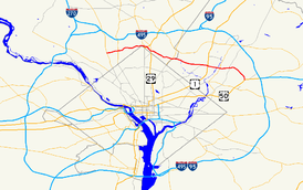
Maryland Route 410 highlighted in redRoute information Maintained by MDSHA, City of Takoma Park, and Prince George's County Length: 13.92 mi[1][2] (22.40 km) Existed: 1930 – present Major junctions West end:  MD 355 in Bethesda
 MD 185 in Chevy Chase
 US 29 in Silver Spring
 MD 650 in Takoma Park
 MD 212 in Hyattsville
 US 1 in Riverdale Park
 MD 201 in Riverdale Park
 MD 295 in East Riverdale
 MD 450 in Landover Hills
 US 50 in Landover Hills
East end: Pennsy Drive in Landover Hills Highway system Maryland highway system
Interstate • US • State • Minor • Former • Turnpikes←  MD 409
MD 413  →
→Maryland Route 410 (MD 410) is a state highway in the U.S. state of Maryland. Known for most of its length as East–West Highway, the highway runs 13.92 mi (22.40 km) from MD 355 in Bethesda east to Pennsy Drive in Landover Hills. MD 410 serves as a major east–west commuter route through the inner suburbs on the north side of Washington, D.C., connecting the commercial districts of Bethesda, Silver Spring, and Hyattsville; the industrial area of Landover Hills; and the residential suburbs of Chevy Chase, Takoma Park, Riverdale. and East Riverdale. The road connects many of the arterial highways and freeways that head out of Washington as well as transit hubs centered around stations of the Washington Metro in Bethesda, Silver Spring, Hyattsville, and New Carrollton, with additional connections to MARC and Amtrak. The highway is maintained mostly by the Maryland State Highway Administration (MDSHA), with small segments maintained by the city of Takoma Park and Prince George's County.
MD 410 was originally built along mostly new alignment between Bethesda and Silver Spring in the late 1920s. The highway was extended east to Hyattsville in the mid 1930s. While the Montgomery County portion has not changed much in the ensuing decades, MD 410 has been realigned and extended multiple times within Prince George's County. These changes include an extension along existing roads further into Hyattsville in the mid 1940s, a realignment within Hyattsville in the mid 1950s, an extension through Riverdale in the late 1960s, and the final extension to Landover Hills in the early 1990s.
Contents
Route description
Montgomery County
MD 410 begins as a one-way pair of streets at the intersection of MD 355 (Wisconsin Avenue) and MD 187 (Old Georgetown Road) at the Bethesda station of the Washington Metro. Montgomery Avenue heads eastbound from MD 355 while the westbound direction is East–West Highway, which passes the Consumer Product Safety Commission and Bethesda-Chevy Chase High School.[1] At the east end of Bethesda's central business district, MD 410 east has a U-turn ramp to MD 410 west, then the two streets come together and head east toward Chevy Chase as East–West Highway.[1][3]
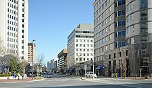 East–West Highway at its western terminus in Bethesda
After crossing the Capital Crescent Trail, MD 410 continues east as a four-lane undivided highway with a speed limit of 30 mph (48 km/h) through residential areas.[1] The state highway passes Maple Avenue, which was formerly MD 82, on the edge of the town of Chevy Chase. MD 410 parallels Columbia Country Club to the south before intersecting MD 185 (Connecticut Avenue). Beyond MD 185, the speed limit increases to 35 mph (56 km/h).[1] After meeting the northern terminus of MD 186 (Brookville Road), the state highway turns northeast and heads into the valley of Rock Creek.[3] MD 410 meets Jones Mill Road and Beach Drive before crossing Rock Creek, then intersects Meadowbrook Drive. Continuing northeast, the state highway gains a narrow median and intersects Grubb Road.[3] After passing the intersection of Washington Avenue and Sundale Drive, MD 410 becomes undivided again and enters an area of high-rise and garden apartments.[3] After passing Rosemary Hills Drive, the state highway curves to the east and comes very close to the north corner boundary of the District of Columbia.[3]
Upon entering Silver Spring, MD 410 intersects MD 390 (16th Street). The state highway curves to the southeast to meet MD 384 (Colesville Road) next to the Silver Spring Metro station and the Silver Spring offices of the National Oceanic and Atmospheric Administration.[3] After the speed limit reduces to 30 mph (48 km/h), MD 410 continues southeast, passing the intersection of Blair Mill Road and Newell Street before arriving at the five-way intersection with U.S. Route 29 (Georgia Avenue).[1][3] From US 29, the state highway turns east onto Burlington Avenue and crosses CSX's Metropolitan Subdivision, MARC's Brunswick Line, and the Red Line of the Washington Metro.[1] At Fenton Street, MD 410 veers southeast onto Philadelphia Avenue, which heads into Takoma Park.[1][3]
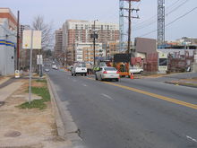 Looking west down East–West Highway in south Silver Spring
MD 410 enters Takoma Park as a two-lane road with a speed limit of 30 mph (48 km/h) through a densely populated residential area.[1] After passing the Takoma Park/Silver Spring campus of Montgomery College, the state highway intersects MD 320 (Piney Branch Road). After a four-way stop at Holly Avenue, MD 410 turns east and intersects Maple Avenue, where the speed limit decreases to 25 mph (40 km/h).[1] The state highway heads toward an intersection with MD 195 (Carroll Avenue) in front of the Takoma Park Volunteer Fire Department. After a short concurrency with MD 195 through Takoma Junction, MD 410 continues east on Ethan Allen Avenue.[1] After a three-way stop at Jackson Avenue, the state highway reaches an intersection with MD 650 (New Hampshire Avenue), where MD 410 leaves Takoma Park and Montgomery County.[1]
Prince George's County
MD 410's name becomes the East–West Highway again upon entering Hyattsville.[2] The state highway heads east from MD 650 as a four-lane undivided highway with a speed limit of 30 mph (48 km/h) through suburban residential areas.[2] MD 410 crosses Sligo Creek and the Sligo Creek Trail before entering a commercial area and meeting MD 212 (Riggs Road). Shortly after MD 212, Ager Road continues southeast straight toward the West Hyattsville Metro station while MD 410 veers east as a four-lane divided highway with a speed limit of 40 mph (64 km/h).[2][3] After crossing Northwest Branch, the state highway enters a commercial area where it passes between The Mall at Prince Georges on the north and the Prince George's Plaza Metro station on the south.[3] After crossing Belcrest Road, which is used to access University Town Center and the National Center for Health Statistics, MD 410 intersects MD 500 (Queens Chapel Road) and Adelphi Road and leaves Hyattsville.
MD 410 expands to a six-lane divided highway with a speed limit of 35 mph (56 km/h) after the MD 500 intersection and passes through a residential area on the southern edge of University Park.[2] The state highway then reaches US 1 and enters Riverdale Park and the town's historic district. MD 410 reduces to a four-lane divided highway and crosses CSX's Capital Subdivision and MARC's Camden Line.[3] The state highway then crosses Northeast Branch and meets MD 201 (Kenilworth Avenue). After crossing MD 201, MD 410 again expand to six lanes. After the intersection with Riverdale Road, the state highway enters the unincorporated area of East Riverdale and assumes the name Riverdale Road.[2] MD 410 changes to a five-lane road with center turn lane with a speed limit of 40 mph (64 km/h) as it passes through residential areas.[2][3] The state highway meets the Baltimore-Washington Parkway (unsigned MD 295) at a diamond interchange.[3] Just east of the parkway, Riverdale Road continues straight toward New Carrollton while MD 410 turns south into Veterans Parkway.[2][3]
MD 410 heads south through a forested area as a four-lane divided highway with a speed limit of 45 mph (72 km/h).[2][3] The state highway intersects MD 450 (Annapolis Road) as the road reaches Landover Hills. MD 410's next intersection is with Ellin Road, which leads to a secondary entrance and park and ride for the New Carrollton Metro station. The state highway meets US 50 (John Hansen Highway) at a diamond interchange, then crosses the Amtrak Northeast Corridor, MARC's Penn Line, and the Orange Line of the Washington Metro.[3] After crossing the railroad tracks, MD 410 enters Ardwick Ardmore Industrial Park and meets its eastern terminus at Pennsy Drive, which heads east toward the primary entrance for the New Carrollton Metro station and Ardwick-Ardmore Road.[3]
History
The Bethesda – Silver Spring Highway was conceived in the late 1920s as a means of directly connecting the two inner suburbs on the north side of Washington.[4] The highway was under construction between 1927 and 1929 and signed as MD 410 by 1930.[4][5] When completed, MD 410 extended between what was then US 240 in Bethesda and 16th Street in Silver Spring, which had been extended north from the District of Columbia in 1928.[4][5] Continuing to the present center of Silver Spring required heading south on 16th Street to Blair Portal, then east on Colesville Road, which had been extended to Blair Portal in 1927, to Georgia Avenue.[4] Most of MD 410 was built on a new alignment with the exception of the part between present day MD 186 and Jones Mill Road, which followed the old Brookville Road.[5]
By 1933, the new state highway was the busiest road in Montgomery County.[4] The road, which became known as East–West Highway, was originally built with a width of 20 feet, but the heavy traffic led the Maryland State Roads Commission (SRC), the predecessor of MDSHA, to suggest in 1934 that the road be widened to 40 feet in the near future. SRC also recommended extending East–West Highway through Silver Spring and Takoma Park to Hyattsville.[6] By 1935, the highway was extended along new alignment east from 16th Street to Takoma Park, then placed on Philadelphia Avenue and Ethan Allen Avenue within Takoma Park.[7] The extension to MD 212 in Hyattsville was completed in 1936.[8]
After World War II, MD 410 was extended even further east and saw significant improvement on its extant sections. By 1946, MD 410 was extended over Ager Road, Hamilton Street, 38th Avenue, and Jefferson Avenue, roads then designated MD 209, to a new eastern terminus at US 1 in Hyattsville.[9][10] In addition, the pre-1946 course saw completion of efforts to widen the road to 40 feet. The highway between Connecticut Avenue (then MD 193) and Georgia Avenue (US 29) was widened in 1946 and 1947.[11] The two segments between Wisconsin Avenue (US 240) and Connecticut Avenue (MD 193) and between MD 650 in Takoma Park and US 1 in Hyattsville were widened in 1950.[12]
Beyond minor improvements, MD 410 in Montgomery County has remained in much the same state since 1950. The only major change was the highway being split onto a one-way pair of streets in Bethesda in 1988.[13] The Prince George's County section has seen more substantial changes over the intervening decades. The first major change in alignment occurred in 1956, when MD 410 was completed on a new alignment as a four-lane divided highway between Ager Road just east of MD 212 and MD 500 at what is now Adelphi Road.[14][15] The state highway was subsequently extended east over what was previously MD 403, known as Colesville Road, to US 1 in Riverdale.[16]
The next change occurred between 1967 and 1970, when MD 410 was extended as a four-lane divided highway on a new alignment east past MD 201 to the Baltimore–Washington Parkway.[17] This extension bypassed and replaced MD 412 between US 1 and the B-W Parkway.[16] The adjoining segment of MD 410 between MD 500 and US 1 was also upgraded to a multi-lane divided highway by 1970.[18] Finally, MD 410 was extended east on Veterans Parkway past US 50 to its current terminus at Pennsy Drive when that section of highway was completed in 1991.[19]
Junction list
County Location Mile
[1][2]Destinations Notes Montgomery Bethesda 0.00  MD 355 (Wisconsin Avenue) / MD 187 north (Old Georgetown Road) – Rockville, North Bethesda, Washington
Western terminus Begin one-way pair
0.45 U-turn to MD 410 west (East–West Highway) End one-way pair Chevy Chase 0.72 Maple Avenue west – Town of Chevy Chase Former MD 82 1.01 MD 185 (Connecticut Avenue) – Kensington, Washington1.38  MD 186 south (Brookville Road) – Chevy Chase Village
1.89 Beach Drive south / Jones Mill Road north – Washington, North Chevy Chase Silver Spring 3.48  MD 390 (16th Street) to MD 97 north (Georgia Avenue) – Washington, Wheaton
3.71  MD 384 (Colesville Road) to US 29 north (Colesville Road) – Downtown Silver Spring, Columbia
4.24 US 29 (Georgia Avenue) – Washington, Downtown Silver SpringTakoma Park 4.96  MD 320 (Piney Branch Road) – Silver Spring, Washington
5.56  MD 195 south (Carroll Avenue) – Takoma Park
West end of concurrency with MD 195 5.63 MD 195 north (Carroll Avenue) – Langley ParkEast end of concurrency with MD 195 6.31 MD 650 (New Hampshire Avenue) – Langley Park, WashingtonPrince George's Hyattsville 7.17 MD 212 (Riggs Road) – Langley Park, Chillum7.35 Ager Road east – Hyattsville Old alignment of MD 410 8.96  MD 500 south (Queens Chapel Road) / Adelphi Road north – Chillum, University Park
Riverdale Park 9.48 US 1 (Baltimore Avenue) – Hyattsville, College Park10.56 MD 201 (Kenilworth Avenue) – Bladensburg, GreenbeltEast Riverdale 11.33 MD 295 (Baltimore–Washington Parkway) – Baltimore, Washington11.68 Riverdale Road east – New Carrollton MD 410 turns south onto Veterans Parkway Landover Hills 12.83 MD 450 (Annapolis Road) – Bladensburg, New Carrollton13.46 US 50 (John Hanson Highway) – Annapolis, WashingtonUS 50 Interchange 5 13.92 Pennsy Drive Eastern terminus 1.000 mi = 1.609 km; 1.000 km = 0.621 mi References
- ^ a b c d e f g h i j k l m "Highway Location Reference: Montgomery County" (PDF). Maryland State Highway Administration. 2009. http://www.marylandroads.com/Location/2009_MONTGOMERY.pdf. Retrieved 2010-10-04.
- ^ a b c d e f g h i j "Highway Location Reference: Prince George's County" (PDF). Maryland State Highway Administration. 2009. http://www.marylandroads.com/Location/2009_PRINCEGEORGES.pdf. Retrieved 2010-10-04.
- ^ a b c d e f g h i j k l m n o p q Google, Inc. Google Maps – Maryland Route 410 (Map). Cartography by Google, Inc. http://maps.google.com/maps?f=d&source=s_d&saddr=md-355+and+montgomery+ave+bethesda,+md&daddr=md-410+and+md-384+silver+spring,+md+to:md-410+and+md-650+takoma+park,+md+to:md-410+and+pennsy+dr+landover+hills,+md&geocode=FQrYUgIdPKRn-ykVwqwge8m3iTE_Fx8zVO6qsA%3B%3B%3BFcUoUgIdhflq-ynnWGB698C3iTGpIdK90qTK6w&hl=en&mra=ls&sll=38.989803,-77.024031&sspn=0.015244,0.038581&ie=UTF8&ll=38.954603,-76.903524&spn=0.030503,0.077162&t=h&z=14. Retrieved 2010-01-23.
- ^ a b c d e Oshel, Robert E.; Slatick, Marilyn S. (1998). Homesites of Distinction: The History of Woodside Park. Silver Spring, MD: Woodside Park Civic Association. http://users.starpower.net/oshel/H02.htm. Retrieved 2010-01-27.
- ^ a b c Maryland Geological Survey. Map of Maryland Showing State Road System: State Aid Roads and Improved County Road Connections (Map) (1930 ed.).
- ^ Report of the State Roads Commission of Maryland. 1931-1934. Baltimore: Maryland State Roads Commission. 1934-12-28. pp. 20, 37. http://www.archive.org/details/reportofstateroa1931mary. Retrieved 2010-01-25.
- ^ Maryland Geological Survey. Map of Maryland Showing State Road System: State Aid Roads and Improved County Road Connections (Map) (1935 ed.).
- ^ Report of the State Roads Commission of Maryland. 1935-1936. Baltimore: Maryland State Roads Commission. 1937-03-04. pp. 105. http://www.archive.org/details/reportofstateroa1935mary. Retrieved 2010-01-25.
- ^ Maryland State Roads Commission. Map of Maryland Showing Highways and Points of Interest (Map) (1940 ed.).
- ^ Maryland State Roads Commission. Maryland: Official Highway Map (Map) (1946-47 ed.).
- ^ Report of the State Roads Commission of Maryland. 1947-1948. Baltimore: Maryland State Roads Commission. 1949-02-15. p. 114. http://www.archive.org/details/reportofstateroa1947mary. Retrieved 2010-01-26.
- ^ Report of the State Roads Commission of Maryland. 1949-1950. Baltimore: Maryland State Roads Commission. 1950-12-20. pp. 126, 152. http://www.archive.org/details/reportofstateroa1949mary. Retrieved 2010-01-26.
- ^ "Traffic Volume Map" (PDF). Maryland State Highway Administration. 1988. http://www.marylandroads.com/Traffic_Volume_Maps/88_Traffic_Volume_Maps.pdf. Retrieved 2010-01-26.
- ^ Maryland State Roads Commission. Maryland: Official Highway Map (Map) (1956 ed.).
- ^ Report of the State Roads Commission of Maryland. 1955-1956. Baltimore: Maryland State Roads Commission. 1956-11-02. p. 148. http://www.archive.org/details/reportofstateroa1955mary. Retrieved 2010-01-26.
- ^ a b Report of the State Roads Commission of Maryland. 1953-1954. Baltimore: Maryland State Roads Commission. 1954-11-12. p. 163. http://www.archive.org/details/reportofstateroa1953mary. Retrieved 2010-01-26.
- ^ Maryland State Roads Commission. Maryland: Official Highway Map (Map) (1967 ed.).
- ^ Maryland State Roads Commission. Maryland: Official Highway Map (Map) (1970 ed.).
- ^ Maryland State Highway Administration. Maryland: Official Highway Map (Map) (1991 ed.).
External links
Roads in Montgomery County, Maryland Maryland State Highways 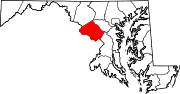
U.S. Routes Interstate Highways Roads by name Cabin John Parkway · Clara Barton Parkway · Cherry Hill Road · Connecticut Avenue · Georgia Avenue · Montrose Road · New Hampshire Avenue · Randolph Road · Sligo Creek Parkway · Wisconsin Avenue · 16th StreetRoads in Prince George's County, Maryland Maryland State Highways 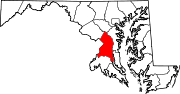
U.S. Routes Interstate Highways Roads by name Categories:- State highways in Maryland
- Roads in Montgomery County, Maryland
- Roads in Prince George's County, Maryland


Wikimedia Foundation. 2010.