- Magherafelt District Council
-
Coordinates: 54°45′07″N 6°36′04″W / 54.752°N 6.601°W
Magherafelt District Geography 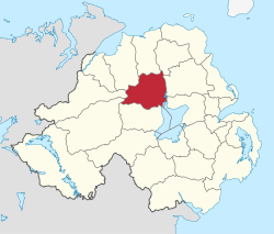
Area
- TotalRanked 12th of 26
573 km²Admin HQ Magherafelt ISO 3166-2 GB-MFT ONS code 95H Demographics Population
- Total (2010)
- DensityRanked 19th
44,700
78 / km²Community Catholic: 64.1%
Protestant: 34.8%Politics Control Sinn Féin: 9
DUP: 3
SDLP: 2
UUP: 2MLAs Mid Ulster
Sinn Féin: 3
DUP: 1
SDLP: 1
UUP: 1MPs Martin McGuinness (Sinn Féin) Meeting place Website http://www.magherafelt.gov.uk Magherafelt District Council is a district council in County Londonderry in Northern Ireland. Council headquarters are in Magherafelt. The Council area stretches from Lough Neagh and the River Bann in the east and into the Sperrin Mountains in the west and is divided by the Moyola River. It covers an area of 214 square miles (550 km2) and has a current population of over 39,500. Local towns in the area include Bellaghy, birthplace of poet Seamus Heaney in 1939.
The Council is composed of 16 elected representatives. Local elections are held every four years on a proportional representation system. At the last election in May 2011, those elected were from the following political parties: 9 Sinn Féin, 3 Democratic Unionist Party (DUP), 2 Social Democratic and Labour Party (SDLP) and 2 Ulster Unionist Party (UUP). The chairman and vice-chairman are elected on an annual basis at the annual general meeting in May or June. The current (2011/12) chairman is Councillor Ian Milne(SF), who represents Moyola electoral area, and the vice-chairman is Councillor George Shiels(UUP), who represents Magherafelt Town electoral area.
In elections for the Westminster Parliament it is part of the Mid Ulster constituency.
Contents
2011 Election results
Party seats change +/- • Sinn Féin 9 +1 • Democratic Unionist Party 3 -1 • Social Democratic and Labour Party 2 = • Ulster Unionist Party 2 =  Map depicting boundaries of Magherafelt District Council electoral regions and wards
Electoral regions
Magherafelt District Council is divided into three electoral regions; Magherafelt Town, Moyola, and Sperrin, each of which is further divided into electoral wards; six in Magherafelt Town and five in both Moyola and Sperrin.
Review of Public Administration
Under the Review of Public Administration (RPA) the council is due to merge with Cookstown District Council and Dungannon and South Tyrone Borough Council in 2011 to form a single council, named Mid-Ulster District Council, for the enlarged area totalling 1714 km² and a population of 120, 096.[1] The next election was due to take place in May 2009, but on 25 April 2008, Shaun Woodward, Secretary of State for Northern Ireland announced that the scheduled 2009 district council elections were to be postponed until the introduction of the eleven new councils in 2011.[2] This super-council however has been postponed for at least five years as of 2010.[3]
See also
- Local Councils in Northern Ireland
References
- ^ "Minister Foster announces decisions on Local Government Reform". DoE. http://www.doeni.gov.uk/index/local_government/minister_foster_announces_decisions_on_local_government_reform.htm. Retrieved 2008-05-31.
- ^ Northern Ireland elections are postponed, BBC News, 25 April 2008, accessed 27 April 2008
- ^ News Letter - Super Councils Postponed for at least five years, published Wednesday 12 May 2010
Local authorities of Northern Ireland Antrim · Ards · Armagh · Ballymena · Ballymoney · Banbridge · Belfast · Carrickfergus · Castlereagh · Coleraine · Cookstown · Craigavon · Derry · Down · Dungannon and South Tyrone · Fermanagh · Larne · Limavady · Lisburn · Magherafelt · Moyle · Newry and Mourne · Newtownabbey · North Down · Omagh · Strabane
Categories:- Politics of County Londonderry
- Local authorities of Northern Ireland


Wikimedia Foundation. 2010.