- Tonopah Test Range
-
For the Tonopah Test Range airfield facilities, see Tonopah Test Range Airport. For other uses of the term "Area 52", see Area 52 (disambiguation).
USAF Tonopah Test Range Nevada 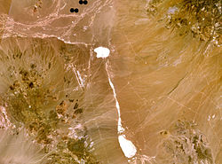
Tonopah airbase and the surrounding test range
(composite NASA Landsat-7 image)Coordinates 37°47′N 116°46′W / 37.78°N 116.77°WCoordinates: 37°47′N 116°46′W / 37.78°N 116.77°W Built 1957 Open to
the publicNO Current
commanderClassified Tonopah Test Range (TTR), also known as Area 52,[1] is a restricted military installation located about 30 miles (48 km) southeast of Tonopah, Nevada. It is part of the northern fringe of the Nellis Range, measuring 625 sq mi (1,620 km2). Tonopah Test Range is located about 70 miles (110 km) northwest of Groom Dry Lake, home of the Area 51 facility. Like the Groom Lake facility, Tonopah is a site of interest to conspiracy theorists, mostly for its use of experimental and classified aircraft. As such, it is not the focus of alien enthusiasts, unlike its neighbor. It is currently used for nuclear weapons stockpile reliability testing, research and development of fusing and firing systems, and testing nuclear weapon delivery systems.[2] The airspace comprises restricted area R-4809 of the Nevada Test and Training Range and is often used for military training.
Contents
Description
The Tonopah Test Range is owned by the United States Department of Energy and is managed by Sandia National Laboratories, a division of Lockheed-Martin, which operates the Tonopah Test Range under an Air Force permit with the National Nuclear Security Administration.[2] The range is part of the Great Basin Desert and lies mostly within the Cactus Flat valley, consisting of horst and graben geology.[2] It is flanked by the Cactus Range hills to the west and the Kawich Range to the east, which is home of Silverbow, one of the largest mining ghost towns in Nevada. The vegetation consists mostly of black sagebrush and creosote bush. It holds a sizable wild horse and burro population, closely monitored by the Bureau of Land Management. Common denizens of the TTR include the gray fox, pronghorn, coyote, and mule deer, along with the native birds sage thrasher, sage grouse, and sage sparrow.[2]
Airfields
One of the primary facilities on the TTR is a large airfield (Area 10), consisting of a 12,000-foot (3,700 m) runway and numerous hangars. This facility is described in detail in the article Tonopah Test Range Airport. About five minor abandoned airfields exist throughout the TTR [3] which were primarily used during World War II by units based at Tonopah Army Air Field (now serving as Tonopah's municipal airport). Only Mellan Airstrip, 11 miles (18 km) southeast of Tonopah Test Range Airport, survived past the 1960s, upgraded to a 5,000 ft (1,500 m) concrete runway. A US Air Force assessment published in 2000 indicated it was a minimally adequate airfield which was used to support tactical C-130 and C-17 training.[4]
Mancamp
About six miles (10 km) north of the airfield is a large housing area called Mancamp. It contains about 50 twin-level dormitories. A cafeteria called the "Wild Horse Cafe" exists, but is currently closed. A recreation center houses a bar, a library, game room, weight room, Olympic size stainless steel indoor pool, racquetball courts, a two-lane bowling alley, a barbecue pad, and an ATM. There is also an athletic track, tennis courts, and softball fields. Just outside of Mancamp a small civilian compound existed, but was mostly dismantled by 2000. Google Earth imagery indicated that Mancamp's streets were renovated sometime between 2003 and 2007.
Sandia National Laboratories
Operations by Sandia are controlled at the TTR Operations Control Center (Area 3), just southeast of the main airfield, which houses the range safety officer, test director, and key engineers.[2] Activities are monitored with video, high-speed cameras, and radar tracking devices. Though nuclear weapons have never been detonated on the TTR, the 1963 test Project Rollercoaster involved the destruction of four weapons, which caused some plutonium to be dispersed into the soil north of Antelope Lake.[2]
History
 Map showing Tonopah Test Range and related federal lands in southern Nevada
In the early 20th century the region was used primarily for mining and some grazing. Early maps from the 1930s indicated a roadway connecting the towns of Caliente and Tonopah via Rachel, which ascended Cedar Pass and crossed through the northern part of the future Tonopah Test Range.[5] In 1940, President Franklin D. Roosevelt directed the establishment of a US Army Air Corps training range in this area. During the 1950s, weapons design research had been conducted largely at the Salton Sea testing base, but haze problems forced the Department of Energy to seek another location.[2] The Tonopah Test Range was withdrawn from public use in 1956 and testing began in 1957 for United States Department of Energy weapons programs. For most of its life, the range was administered by Sandia National Laboratories. In 2008 the National Nuclear Security Administration proposed to move its facilities on the Tonopah Test Range to White Sands Missile Range,[6] a move that local and state politicians say would cost the area jobs and lost revenue.
Constant Peg
Main article: Constant PegFrom 1979-1988 Tonopah hosted a MiG air combat training program code named Constant Peg. The brainchild of Colonel Gail Peck, the program was run by the 4477th Test & Evaluation Squadron, "Red Eagles", and allowed American aircrews the opportunity to fly – and to fly against – the fighter aircraft of their Cold War rivals. Constant Peg was formally declassified on November 15, 2006, though it had been discussed by name in various media since the mid-1980s. At the height of the operation, the Red Eagles flew 14 MiG-21 Fishbeds and 9 MiG-23 Floggers (with additional airframes of both types available for cannibalization), and had also operated the MiG-17 Fresco until 1982, when the type proved too dangerous to continue flying.[7] Between July 1979 and its final sortie in March 1988, 5,930 aircrew were exposed to Constant Peg.[7]
Stealth
- For full information on F-117 operations at the TTR, see the article Tonopah Test Range Airport and F-117 Nighthawk.
F-117s of the 4450th Tactical Group operated from Tonopah in secret from 1982 through 1989 while the program was still classified. During this period Mancamp was connected to the airfield by shuttle bus service, while the airfield in turn was connected to Nellis Air Force Base by between five to twenty Key Air Boeing 727 and/or Boeing 737 flights per day from Nellis to Tonopah.[8] The airfield was also serviced by one or two JANET Boeing 737 flights daily, which were presumably from McCarran International Airport and served Sandia National Laboratories employees. In early 1991, Key Air lost the contract and the service was taken over by American Trans Air Boeing 727 aircraft.
Contamination
It was revealed in 2007 that during the 1980s a contractor had dumped up to 1,000 pounds of urea at a pond on the TTR, resulting in the die-off of 61 horses in 1988.[9] The fluid had been used as a de-icing agent. The Bureau of Land Management investigated in November 1988, and imposed remedial actions and assessed a $15,000 fine. In 2007 over concerns that the chemical was infiltrating groundwater, a whistleblower unsuccessfully attempted to get the Environmental Protection Agency to intervene, leading to an August 2007 inquiry with the Department of the Interior by Senator Harry Reid.
Popular culture
"Area 52" has been featured in television news casts, such as presented by Las Vegas Channel 8 News.[10] Area 52 has also been featured on The History Channel's UFO Hunters.[11] In both of these presentations Area 52 is speculated to facilitate the use of highly advanced aircraft technology including craft such as flying saucers or UFOs. In the television series Stargate SG-1, Area 52 is actually the code designation for Stargate Command in the US treasury. In an episode of Total Drama World Tour, Area 52 is visited right before the contestants get to Area 51. In the Warner Bros movie Looney Tunes Back in Action DJ Drake, Bugs Bunny, Daffy Duck and Kate Houghton visit a secret military base in The Nevada Desert, used mainly as a storage for extraterrestrial lifeforms and technology and government secrets , called Area 52. The base in the movie was the "real" Area 51, and the name Area 51 was only a cover for Area 52.
Movie
Screen Gems announces New 3-D CGI Computer-animated Movie set in area 52 called "Area 52" Aka "Area One", produced and distributed by Screen Gems.
See also
- Aberdeen Proving Ground
- Air Force Flight Test Center
- Dugway Proving Ground
- Naval Air Weapons Station China Lake
- Nevada Test Site
References
- ^ "Closure report for Corrective Action Unit 426, US Department of Energy / Bechtel Nevada, August 1998. p34 identifies TTR as "area 52"
- ^ a b c d e f g Annual Site Environmental Report: Tonopah Test Range, Nevada and Kauai Test Facility, Hawaii, 2003, Sandia National Laboratories, Albuquerque, New Mexico, 105 pp.
- ^ Abandoned & Little Known Airfields: Central Nevada, Paul Freeman, accessed 18 August 2010.
- ^ Environmental Assessment for the Proposed Cedar Pass Airfield, 99 CES/CEVN, Nellis AFB, April 2000, accessed 18 August 2010.
- ^ Regional Aeronautical Chart 11M, U.S. Coast and Geodetic Survey, NOAA Historical Charts website, [1].
- ^ Plan to close Tonopah Test Range criticized, Las Vegas Review Journal, March 27, 2008.
- ^ a b Davies, Steve (1988). Red Eagles: America's Secret MiGs. Osprey Publishing. ISBN 978-1-84603-378-0. http://www.constantpeg.com.
- ^ "Six F-117As Flown in Panama Invasion". Aviation Week & Space Technology (McGraw Hill): pp. 30. March 5, 1990.
- ^ CONTAMINATION PROBE: 61 horses died in '88 at test site, Las Vegas Review Journal, Nov. 24, 2007.
- ^ Las Vegas Channel 8 News story on Area 52
- ^ Video of History Channel's UFO Hunters Area 52 episode
External links
Categories:- Landmarks in Nevada
- Facilities of the United States Air Force
- Buildings and structures in Nye County, Nevada
- Military facilities in Nevada
- 1957 establishments in the United States


Wikimedia Foundation. 2010.