- Oissel
-
Oissel

 OisselLocation within Upper Normandy region
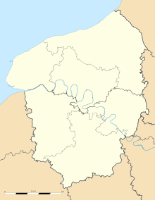 Oissel
Administration Country France Region Upper Normandy Department Seine-Maritime Arrondissement Rouen Canton Saint-Étienne-du-Rouvray Intercommunality CREA Mayor Thierry Foucaud
(2008 - 2014)Statistics Elevation 2–128 m (6.6–420 ft)
(avg. 10 m/33 ft)Land area1 22.19 km2 (8.57 sq mi) Population2 11,611 (2006) - Density 523 /km2 (1,350 /sq mi) INSEE/Postal code 76484/ 76350 1 French Land Register data, which excludes lakes, ponds, glaciers > 1 km² (0.386 sq mi or 247 acres) and river estuaries. 2 Population without double counting: residents of multiple communes (e.g., students and military personnel) only counted once. Coordinates: 49°20′33″N 1°05′32″E / 49.3425°N 01.09222°E
Oissel is a commune in the Seine-Maritime department in the Haute-Normandie region in northern France.
Contents
Geography
A suburban and light industrial town situated by the banks of the river Seine, just 8 miles (13 km) south of Rouen at the junction of the D18 and the D13 roads. Junction 22 of the A13 autoroute is entirely within the commune’s borders. SNCF operates a TER rail service here.
Heraldry
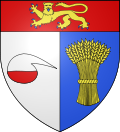
The arms of Oissel are blazoned :
Per pale argent and azure, a half-filled alembic gules and a garb Or, and on a chief gules, a leopard Or, armed and langued azure.Population
Population history 1962 1968 1975 1982 1990 1999 2006 9936 9949 10,501 11,712 11,444 11,053 11,611 Starting in 1962: Population without duplicates People
- Daniel Horlaville, footballer born in 1945.
- Raoul Grimoin-Sanson (1860-1941), cinematographic inventor.
- Grégory Tafforeau, footballer born in 1976.
- Thierry Foucaud, 1954- , Politician.
Places of interest
- The church of St.Martin, dating from the nineteenth century.
- The sixteenth century manorhouse, the Manoir de La Chapelle.
- The Dambray Pavillon, from the seventeenth century.
- The Château de La Perreuse.
See also
References
External links
- Oissel official website (French)
- Pictures of Oissel, the photoblog of an osselien.
- Oissel on the Quid website (French)
Categories:- Communes of Seine-Maritime
- Rouen geography stubs


Wikimedia Foundation. 2010.