- U.S. Route 14
-
U.S. Route 14

Route information Length: 1,429 mi[1] (2,300 km) Existed: 1926[1] – present Major junctions West end: 
 US 16 / US 20 at Yellowstone National Park
 I-29 at Brookings, SD
 US 169 at Mankato, MN
 I-35 at Owatonna, MN
 US 61 at Winona, MN
 US 12 at Madison, WI and Des Plaines, IL
 I-294 at Des Plaines, IL
 I-94 at Chicago, IL
East end:  US 41 at Chicago, IL
Highway system United States Numbered Highways
List • Bannered • Divided • ReplacedU.S. Route 14 (U.S. 14), an east–west route, is one of the original United States highways of 1926. It currently has a length of 1,398 miles (2,250 km), but it had a peak length of 1,429 miles (2,300 km). For much of its length, it runs roughly parallel to Interstate 90.
As of 2004, the highway's eastern terminus is in Chicago, Illinois. Its western terminus is the east entrance of Yellowstone National Park in Wyoming, with the western terminus of U.S. Route 16 and the western terminus of the eastern segment of U.S. Route 20.[2]
Contents
Route description
Wyoming
Main article: U.S. Route 14 in Wyoming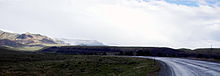 U.S. 14 in Wyoming facing the Big Horn Mountains from the west.
U.S. 14 begins at the east entrance to Yellowstone National Park, along with U.S. 16 and the eastern segment of U.S. 20. It travels through the Shoshone National Forest to Cody, where U.S. 14A splits off to the north. Both routes traverse the dry Bighorn Basin, followed by a steep ascent up the Big Horn Mountains and through the Bighorn National Forest, where they rejoin at Burgess Junction. The highway descends the eastern slope of the Bighorns between Burgess Junction and Dayton. U.S. 14 briefly follows I-90 south from Ranchester to Sheridan. The highway turns east and then south to again join I-90 near Gillette. It splits off for a short time to Carlile, then rejoins I-90 which it follows to the state line.
South Dakota
The South Dakota section of U.S. 14, other than a concurrency with Interstate 90, is defined in the South Dakota Codified Laws.[3]
The Laura Ingalls Wilder Historic Highway incorporates U.S. 14 from South Dakota in the west to Rochester, Minnesota in the east, where the historic roadway continues on U.S. 63. The author moved to De Smet, SD from Walnut Grove, MN via the Dakota, Minnesota, and Eastern, which parallels the highway from the Black Hills to La Crosse, WI.
US 14 and US 83 are the only national routes serving Pierre, South Dakota, one of only five state capitals not on the Interstate Highway System.
Minnesota
U.S. 14 enters the state from South Dakota west of Lake Benton. It goes east through several small towns on a two-lane road until New Ulm, where it is briefly a divided highway. From New Ulm to Mankato, the highway lies north of the Minnesota River. Shortly before coming to the Mankato/North Mankato area, U.S. 14 becomes a freeway bypass, which becomes an expressway east of Mankato. It currently continues east through Waseca and at Owatonna, it overlaps Interstate 35. It then heads east towards Rochester, with an expressway segment beginning at Minnesota State Highway 56 and continuing east into Rochester. Once it enters Rochester, it has a concurrency with U.S. Route 52. After the concurrency, it continues through Rochester as a divided highway. After Rochester, the highway parallels Interstate 90 until Winona, where U.S. 14 gets picked up by U.S. Route 61. The two highways run concurrently the rest of the way in Minnesota, and cross the Mississippi River at La Crescent over the La Crosse West Channel Bridge.
Currently, U.S. 14 is being expanded to a full, limited-access freeway from approximately three miles west of Janesville to Interstate 35 at Owatonna. Most of the new route is located south of the existing alignment so as to avoid overlapping Interstate 35. Once finished, the expansion (which is scheduled to be completed by 2012) will ensure the entire portion of U.S. 14 from North Mankato to Owatonna is a combination of either expressway or freeway.
The Minnesota section of U.S. 14 is defined as part of Constitutional Route 7 and Trunk Highways 121 and 122 in the Minnesota Statutes.[4]
Wisconsin
Main article: U.S. Route 14 in WisconsinU.S. 14 enters the state of Wisconsin along with U.S. Route 61 across the Mississippi River into La Crosse. The route passes through Madison, Janesville and the village square of Walworth. U.S. 14 then exits into Illinois at Big Foot Prairie.
Illinois
Main article: U.S. Route 14 in Illinois U.S. 14 at the Illinois-Wisconsin border.
In the state of Illinois, U.S. 14 runs southeast from north of Harvard to Chicago via Woodstock and the northwest suburbs. East of the Fox River, U.S. 14 generally has four lanes; at times it is a high-speed divided highway, and parallels the Union Pacific Northwest Metra Line. Through the northwest suburbs of Chicago, this route is commonly referred to as "Northwest Highway" and is a very busy thoroughfare. East of Des Plaines, U.S. 14 becomes Dempster Street until its intersection with Waukegan Road. From here, U.S. 14 follows Waukegan Road, Caldwell Avenue, Peterson Avenue, and Ridge Avenue to its eastern end, at the corner of Broadway and U.S. 41 (Foster Avenue).[5]
At an earlier point, U.S. 14 extended south on Lake Shore Drive onto Michigan Avenue.[2]
History
U.S. 14 was originally the "Black and Yellow Trail", so named as it connected Minnesota with the Black Hills and Yellowstone National Park.
In Chicago's Northwest Suburbs, it is known as Northwest Highway due to its direction as well as it paralleling the old Chicago and North Western railroad (now Union Pacific.) It was originally called the Northwest Highway from Chicago to New Ulm, Minnesota, and some street signs in New Ulm, Chicago, and towns in between still show the old designation.
From Ucross west to Sheridan, Wyoming, US 14 was initially designated U.S. Route 116 in 1926. US 116 was extended west to Cody in 1933, absorbing the Deaver-Cody US 420. The next year, US 116 became an extension of US 14. Part of this extension, including all of US 420, is now US 14A.
Major intersections
- Interstate 29 in Brookings, South Dakota
- U.S. Route 75 in Lake Benton, Minnesota
- U.S. Route 71 in Sanborn, Minnesota
- U.S. Route 169 in Mankato, Minnesota
- Interstate 35 in Owatonna, Minnesota
- U.S. Route 218 in Owatonna, Minnesota
- U.S. Route 52 and U.S. Route 63 in Rochester, Minnesota
- Interstate 39 in Janesville, Wisconsin
- U.S. Route 45 and U.S. Route 12 in Des Plaines, Illinois
- Interstate 294 in Des Plaines, Illinois
- Interstate 94 in Chicago, Illinois
- U.S. Highway 41 in Chicago, Illinois
See also
Bannered and suffixed routes
- U.S. Route 14 Alternate in Sturgis, South Dakota
- U.S. Route 14 Alternate in Cody, Wyoming
- U.S. Route 14 City in Janesville, Wisconsin (former)
References
- ^ a b Droz, Robert V. U.S. Highways : From US 1 to (US 830). URL accessed 22:46, 20 February 2006 (UTC).
- ^ a b Endpoints of US highways
- ^ "South Dakota Codified Laws § 31-4-134". South Dakota Legislature, Legislative Research Council. 2007. http://legis.state.sd.us/statutes/DisplayStatute.aspx?Type=Statute&Statute=31-4-134.
- ^ "Minnesota Statutes §§ 161.114(2)". http://ros.leg.mn/bin/getpub.php?pubtype=STAT_CHAP_SEC&year=2006§ion=161.114. and "161.115(52), (53)". Office of Revisor of Statutes, State of Minnesota. 2006. http://ros.leg.mn/bin/getpub.php?pubtype=STAT_CHAP_SEC&year=2006§ion=161.115.
- ^ "Illinois Official Highway Map:Chicago and Vicinity". Illinois Department of Transportation. http://wrc.dot.il.gov/stateroadmap/images/pdf/chicago.pdf. Retrieved 2007-07-29.
External links
 Main U.S. Routes
1 2 3 4 5 6 7 8 9 10 11 12 13 14 15 16 17 18 19 20 21 22 23 24 25 26 27 28 29 30 31 32 33 34 35 36 37 38 40 41 42 43 44 45 46 48 49 50 51 52 53 54 55 56 57 58 59 60 61 62 63 64 65 66 67 68 69 70 71 72 73 74 75 76 77 78 79 80 81 82 83 84 85 87 89 90 91 92 93 94 95 96 97 98 99 101 163 400 412 425 Lists U.S. Routes • Bannered • Divided • Bypassed Browse numbered routes ←  WYO 13
WY WYO 14  →
→←  SD 13
SD 13SD SD 15  →
→←  MN 13
MN 13MN MN 15  →
→←  WIS 13
WI WIS 14  →
→←  IL 13
IL 13IL IL 14  →Categories:
- U.S. Route 14
- U.S. Highway System
- U.S. Highways in Minnesota
- U.S. Highways in South Dakota
- U.S. Highways in Wisconsin
- U.S. Highways in Wyoming


Wikimedia Foundation. 2010.