- Isle of Mull
-
"Mull" redirects here. For other uses, see Mull (disambiguation).
Isle of Mull Location 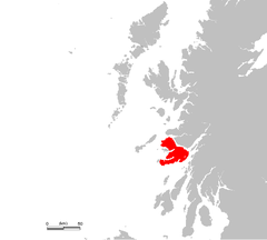
OS grid reference NM590354 Names Gaelic name  Muile (help·info)
Norse name Myl Meaning of name pre-Gaelic Area and summit Area 87,535 hectares (337.97 sq mi) Area rank 4 Highest elevation Ben More 966 m Population Population 2,667 Population rank 8 out of 97 Main settlement Tobermory Groupings Island group Mull Local Authority Argyll and Bute 

References [1][2][3][4] If shown, area and population ranks are for all Scottish islands and all inhabited Scottish islands respectively. Population data is from 2001 census. The Isle of Mull or simply Mull (Scottish Gaelic Muile, pronounced [ˈmulə]) is the second largest island of the Inner Hebrides, off the west coast of Scotland in the council area of Argyll and Bute.
With an area of 875.35 square kilometres (337.97 sq mi) Mull is the fourth largest Scottish island and the fourth largest island surrounding Great Britain. In the 2001 census the usual resident population of Mull was 2,667; in the summer this is supplemented by many tourists. Much of the population lives in Tobermory, the only burgh on the island until 1973, and its capital.
Tobermory is also home to Mull's only single malt Scotch whisky distillery, Tobermory (formerly Ledaig).[5]
Contents
History
It is widely understood that Mull was inhabited shortly after the end of the last Ice Age, from around 6000 BC. Bronze Age inhabitants built menhirs, brochs and a stone circle with examples of burial cairns, cists, standing stones, stone circles, pottery and knife blades providing compelling evidence.
Between 600 BC to 400 AD Iron Age inhabitants were building protective forts, duns and crannogs. The early Christian period began in the 6th Century, with 563AD being a pivotal point as it is believed that Christianity was brought to this part of northern Britain by St. Columba, when he arrived from Ireland to set up a monastery on the Island of Iona just off the south-west point of Mull.
In the 14th century Mull became part of the Lordship of the Isles. After the collapse of the Lordship in 1493 the island was taken over by the clan MacLean, and in 1681 by the clan Campbell.
Legend has it that the wreck of a Spanish galleon, laden with gold, lies somewhere in the mud at the bottom of Tobermory Bay - although the ship's true identity, and cargo, are in dispute. By some accounts, the Florencia (or Florida, or San Francisco), a member of the defeated Spanish Armada fleeing the English fleet in 1588, anchored in Tobermory to take on provisions. Following a dispute over payment, the ship caught fire and the gunpowder magazine exploded, sinking the vessel. In her hold, reputedly, was £300,000 in gold bullion.[6] Other sources claim the vessel was the San Juan de Sicilia (or San Juan de Baptista), which, records indicate, carried troops, not treasure.[7][8] According to that account, the island's chief, Lachlan Mor Maclean, struck a deal with the Spanish commander to reprovision and refit the ship in return for military intervention on the side of the MacLeans in their feud with enemies on nearby islands.[9][10][11] Whatever the true story, numerous searches for the wreck, and its rumored treasure, took place from the mid-17th century to the end of the 20th century.[12] No significant treasure has ever been recovered in Tobermory Bay.[13]
In 1773 the island was visited by Samuel Johnson and James Boswell during their famous Tour of the Western Islands.
During the Highland Clearances in the 18th and 19th centuries, the population fell from 10,000 to less than 3,000.
The whole island became a Restricted Area during World War 2. The bay at Tobermory became a naval base commanded from HMS Western Isles. The base and the Restricted Area were under Commodore (later Vice Admiral) Sir Gilbert Stephenson, whose strict discipline and ferocious temper earned him the nickname "The Terror of Tobermory".[14] The base was used to train Escort Groups in anti-submarine warfare. 911 ships passed through the base between 1940 and 1945.
Mull boasts such historic buildings as Duart Castle and Torosay Castle, both open to the public from Easter to September. (Torosay Castle is to open Easter until end of June 2011(subject to change due to sale of castle.) Moy Castle is a small distressed castle on the shore of Lochbuie. The mausoleum of Lachlan Macquarie, Governor of New South Wales from 1809 to 1822, may be found in the village of Gruline on the island (Macquarie had been born on the nearby island of Ulva). A notable 17th-century poetess Mary Macleod (Mairi Nighean Alasdair Ruaidh) was said to have been banished here.
Schooling
There is one secondary school on the island,based in Tobermory, and several primary schools. Secondary pupils (age 11 - 18) from Iona, Bunessan and Fionnphort in the south west attend Oban High School, staying in an Oban hostel from Monday to Thursday.
Geography
 Ordnance Survey map of Mull and surrounding area
Mull has a coastline of 480 kilometres (300 mi) and its climate is moderated by the Gulf Stream. The island has a mountainous core, the highest peak on the island being Ben More, which reaches 966 metres (3,169 ft). Various peninsulas, which are predominantly moorland, radiate from the centre.
The Aros peninsula to the north includes the main town of Tobermory, which was a burgh until 1973 when burghs were abolished. Other settlements include Salen and Calgary. The Ross of Mull lies to the south west and includes the villages of Bunessan, Pennyghael, Uisken and Fionnphort. Lochbuie, Lochdon and Craignure lie to the east.
Numerous islands lie off the west coast of Mull, including Erraid, Inch Kenneth, Iona and Ulva. Smaller uninhabited islands include Eorsa, Gometra, Little Colonsay, the Treshnish Isles and Staffa of Fingal's Cave fame. Calve Island is an uninhabited island in Tobermory Bay. Two outlying rock lighthouses are also visible from the south west of Mull, Dubh Artach and Skerryvore. The Torran Rocks are a large shoal of reefs, islets and skerries, approximately 15 square miles (39 km2) in extent, located two miles (3 km) to the south west, between the Ross of Mull peninsula and Dubh Artach. Frank Lockwood's Island near Lochbuie is named after the brother-in-law of the 21st MacLean of Lochbuie, who was Solicitor General from 1894-5.[15]
Part of the indented west coast of Mull and some of the offshore islands there are part of the Loch Na Keal National Scenic Area, one of 40 in Scotland.[16]
Economy
Farming, fishing and burning seaweed to kelp ash (used in the manufacture of soap and glass) were the main economic activities on the island until the 19th century. Tobermory was built by the British Fisheries Society in 1788 as a planned settlement to support the fishing industry. In the mid 19th century the Highland Potato Famine and the Highland Clearances reduced the population by two thirds and the island economy collapsed. In the early 20th century there were more sheep than people.
The economy began to revive when the construction of Craignure pier in 1964 started to bring tourists. Tourism is now the mainstay of the island economy. Ecotourism became popular from the 1990s and the re-introduction of White-tailed eagles in 2005 became a particular ecotourist drawcard.[17]
There is a small amount of farming, aquaculture and fishing, and Forestry Commission Scotland has several plantations on the island. Tobermory also has one whisky distillery and one brewery. The brewery makes beer named after aspects of island history, such as Terror of Tobermory Dark Ale, Galleon Gold Ale and Red Monk of Iona Amber Ale.
Transport
Ferry links to Mull from the mainland include Oban to Craignure (approx. 45 minutes), Kilchoan to Tobermory (approx. 35 minutes) and Lochaline to Fishnish (approx. 15 minutes). Although advance bookings are not required for the Kilchoan or Fishnish ferries, access does require driving on single-track roads on the mainland side.
There are ferry links from Fionnphort on Mull to the neighbouring island of Iona and from Oskamull to Ulva. In past years there were direct sailings to Oban (calling at Drimnin, Salen, Lochaline and Craignure), and Barra, Coll and Tiree from Tobermory. During the summer there was also a sailing to Staffa and Iona from Oban which called at Tobermory.
The Isle of Mull Railway runs from Craignure to Torosay Castle. The service closed in October 2010 apart from a one off closing special day on 4 December 2010.
It is possible to fly to Mull in a private light aircraft using a landing strip near Salen.[18] There was a sea plane that linked Tobermory with Glasgow and Oban. The regular scheduled service terminated in 2009. Loganair operated a scheduled service to Glasgow in the 1960s from Glenforsa.
Buses are operated by Bowmans Coaches (Mull) Ltd.. Services operate from Tobermory to Calgary via Dervaig (Service 494), Tobermory to Craignure via Salen (Service 495), and Craignure to Fionnphort via Bunessan (Service 496). Limited services operate to Lochbuie and Gruline.[19] A minibus service also operates seasonally from Craignure to Duart Castle.[20]
Communications
Mull was connected to the mainland by a submarine telegraph cable between Oban and Grass Point in 1871. There were telegraph offices at Tobermory, Dervaig, Calgary, Craignure, Pennyghael, Tiroran, Fionnphort, Bunessan and Iona.[21]
The Post Office built an experimental wireless telegraph station on Meall an Inbhire near Tobermory in 1892.[22]
AM radio, broadcast from Oban, came to the island in 1930 and television in 1954. New AM radio and UHF television transmitters were constructed on Druim Mòr, 1 mile west of Torosay Castle, in 1978. Digital transmissions commenced on 15 November 1998 and analogue transmissions ceased on 27 October 2010. The digital transmitters have 21 relays on Mull, surrounding islands and parts of the mainland. They are collectively called the Torosay Transmitter Group.
Media and the arts
Mull has been used as a location in a number of feature films over the years. These include Entrapment, Highlander: Endgame, Eye of the Needle, I Know Where I'm Going, Kidnapped, When Eight Bells Toll and Blooded was filmed in the more remote parts of the Island. Mull also served as the location for The Sea Change, which began filming towards the end of 2008.[23][24]
 Duart Castle, Isle of Mull
The BBC children's TV series Balamory features the town of Tobermory on the island. This increased tourism as it offers a range of activities to do around the island.
Mull Theatre is a professional theatre company based in a new (2008) theatre production centre on the outskirts of Tobermory.[25] Funded by the Scottish Arts Council, the company commissions plays, tours throughout Scotland and beyond and runs an education and outreach programme. It started at the "Mull Little Theatre" at Dervaig in 1966 and was the "Smallest Professional Theatre in the World" according to the Guinness World Records. The National Theatre of Scotland were in residence at the Mull Theatre in April 2009.[citation needed] AN TOBAR, based in Tobermory, is the only publicly funded multidisciplinary arts centre in Argyll. Established in 1997, it is a centre for visual arts, crafts and music.[26]
Wildlife film-maker Simon King went on location to Mull for the first week of Springwatch with Bill Oddie, where he observed a resident family of white-tailed eagles – a male and female named Skye and Frisa respectively, and their two chicks, Itchy and Scratchy. Wildlife cameraman Gordon Buchanan recently returned to his native Mull to film a year in the life of the wildlife. First broadcast in 2005 for the Natural World series, "Eagle Island" focuses on sea eagles, golden eagles, otters, basking sharks and the cetaceans found off the coast.[27]
The singer song writer Colin MacIntyre famously once used the name Mull Historical Society as a pseudonym. Born on the island he took the name from the actual Historical Society who have since changed their name to Mull Historical and Archaeological Society.
Natural history
The island is home to over 250 different bird species including the White-tailed Eagle, which was reintroduced in the nearby Island of Rùm and migrated to Mull, where it now has a stronghold. Minke whales, porpoises and dolphins are among the sea life that can be seen on boat tours from Mull.
Sport
 Sunrise over the Sound of Mull
The Tour of Mull is a closed road rally event held on the island every October. While some well off competitors benefit from superior cars, the locals benefit from their knowledge of the roads and thus anyone can win. "The Best Rally In The World" is the title of a book written by the founder of the event, Brian Molyneux. Previously sponsored by Philips, it has been sponsored since 2005 by Tunnock's, the Lanarkshire biscuit manufacturer.[28][29]
There are several shipwrecks around the shores which offer scuba diving.
There is an Isle of Mull Cycling Club.
Mull Runners organise a half marathon and 10K run each August. It is run between Craignure and Salen.
Rugby is played at Garmony (beside the Craignure to Salen road 6.5 miles north of Craignure). The Mull Rugby 7s Competition takes place annually in May at The Isle of Mull R.F.C's rugby club.
There are golf courses at Tobermory (Erray Park), Craignure (beside the Craignure to Salen road a mile north of Craignure) and on the Isle of Iona.
Mull Highland Games are held each August in the grounds of Tobermory Golf Club (Erray Park). Events include Heavy Weights, Light Field, and Highland Dance. See the Scottish Highland Games Association website for dates.
There is a swimming pool at the Isle of Mull Hotel, Craignure open to the general public at advertised times.
There are tennis courts in Tobermory. Apply at the Argyll and Bute Council Offices, Breadalbane Street, Tobermory for details.
Community initiatives
Following a research and community consultation process undertaken in 1996/7 a development trust was created to identify key goals for the communities of Mull and Iona. Mull & Iona Community Trust (MICT)[30] was formed in 1997 and published a comprehensive "Community Regeneration Strategy" for the islands. They have purchased the only butchers' shop on the island (closed February 2010), created a community run Countryside Ranger service, instigated various recycling initiatives and provide a fundraising and training consultancy.[31]
See also
References
- Baird, Bob (1995) Shipwrecks of the West of Scotland. Glasgow. Nekton Books. ISBN 1897995024
- Currie, Jo. (2001) Mull: The Island and Its People. Birlinn Ltd.
- Jermy, A.C. and Crabbe, J.A. (Ed) (1978) The Island of Mull a Survey of its Flora and Environment. London. British Museum (Natural History).
- Mull Theatre
Footnotes
- ^ 2001 UK Census per List of islands of Scotland
- ^ Haswell-Smith, Hamish (2004). The Scottish Islands. Edinburgh: Canongate. ISBN 1841954543.
- ^ Ordnance Survey. Get-a-map (Map). http://www.ordnancesurvey.co.uk/oswebsite/getamap/.
- ^ Anderson, Joseph (Ed.) (1893) Orkneyinga Saga. Translated by Jón A. Hjaltalin & Gilbert Goudie. Edinburgh. James Thin and Mercat Press (1990 reprint). ISBN 0-901824-25-9
- ^ Tobermory Distillery tobermory.co.uk Retrieved 2010-07-10.
- ^ A Clan Feud, a Spanish Galleon, and a Big Bang. lostfort.blogspot.com Retrieved 2010-07-10.
- ^ The Galleon San Francisco. shipmodeling.net Retrieved 2010-07-10.
- ^ The Tobermory Wreck. news.scotsman.com Retrieved 2010-07-10.
- ^ Martin, Colin; Parker, Geoffrey (1988), The Spanish Armada, New York: W. W. Norton & Company, p. 244, ISBN 0-393-02607-8
- ^ Campbell of Airds, Alastair (2002), A History of Clan Campbell; Volume 2; From Flodden to the Restoration, Edinburgh: Edinburgh University Press, p. 95, ISBN 1-902930-18-5
- ^ Lewis, Michael (1960), The Spanish Armada, London: B. T. Batsford Ltd
- ^ Martin, Colin (1975), Full Fathom Five: Wrecks of the Spanish Armada, New York: The Viking Press, p. 58, ISBN 0-670-33193-7
- ^ Tobermory Bay. reese.org Retrieved 2010-07-10.
- ^ Baker, Richard (1972). The Terror of Tobermory: Vice-Admiral Sir Gilbert Stephenson, KBE, CB, CMG. W.H. Allen. ISBN 978-1841581972.
- ^ Baird (1995) p. 142
- ^ "National Scenic Areas". SNH. Retrieved 30 Mar 2011.
- ^ "Wildlife at work: The economic impact of white-tailed eagles on the Isle of Mull". Royal Society for the Protection of Birds. 3 Mar 2011. http://www.rspb.org.uk/Images/wildlifeatwork_tcm9-282134.pdf.
- ^ "Transport Links" The Glen Forsa Hotel. Retrieved 14th July 2008.
- ^ http://www.bowmanstours.co.uk/timetables.htm
- ^ http://www.duartnews.com/duartnews.experience.htm
- ^ P. A. Macnab (1970). The Isle of Mull. David & Charles. pp. 129.
- ^ Electrical engineering. 9. 1913. p. 623.
- ^ "The Sea Change" theseachange.wordpress.com. Retrieved 30 December 2008.
- ^ "The Sea Change" tailormadeproductions.com. Retrieved 30 December 2008.
- ^ "Druimfin, the new home for Mull Theatre". Mull Theatre. http://www.mulltheatre.com/centre_building.htm. Retrieved 2009-07-26.
- ^ "Welcome to AN TOBAR, Tobermory, Isle of Mull" antobar.co.uk. Retrieved 21 June 2010.
- ^ "Eagle Island with Gordon Buchanan" Mike Birkhead Associates. Retrieved 21 June 2008.
- ^ "Tunnock's Tour of Mull" 2300club.org. Retrieved 24 April 2011.
- ^ "Tour of Mull Rally 1969-2002" Mullcarclub.co.uk. Retrieved 27 September 2008.
- ^ MICT
- ^ DTA Scotland Directory of Members
External links
- Geology of Mull.
- Geology of Mull and Iona portal
- Tobermory - 360° panoramas
- Mull and Iona Chamber of Commerce
- Mull and Iona Community Trust
- 2300 Club - Tour of Mull
- Isle of Mull website
- The Internet Guide to Scotland - Mull
- Mull Highland Games
- Bird and wildlife on Mull
- Mull Genealogy - for those with family links with the island
- Scotland the Movie - Mull
- Mull Theatre
- Mull's History - A synopsis
Mull Main settlements 
Smaller settlements Geographical features History Local culture and economy Surrounding islands Calve Island · Dubh Artach · Eorsa · Erraid · Gometra · Inch Kenneth · Iona · Little Colonsay · Samalan Island · Skerryvore · Staffa · Torran Rocks · Treshnish Isles · Ulva ·Inhabited islands of the Hebrides Inner Hebrides 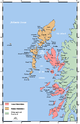
Outer Hebrides Baleshare · Barra · Benbecula · Berneray · Eriskay · Flodaigh · Fraoch-eilean · Great Bernera · Grimsay (North) · Grimsay (South) · Lewis and Harris · North Uist · Scalpay · South Uist · VatersayNational Scenic Areas in Scotland The Borders Firth of Clyde and Mainland Argyll Stirling Perth and Kinross Grampians Highland Assynt-Coigach • Ben Nevis and Glen Coe • Dornoch Firth • Glen Affric • Glen Strathfarrar • Kintail • Knoydart • Kyle of Tongue • Loch Shiel • Morar, Moidart and Ardnamurchan • North-West Sutherland • Wester RossHebrides The Cuillin Hills • Jura • Lynn of Lorn • Loch na Keal, Isle of Mull • Scarba, Lunga and The Garvellachs • Small Isles • St Kilda • South Lewis, Harris and North Uist • South Uist Machair • TrotternishNorthern Isles Islands of Scotland Northern Isles 
Hebrides Other Categories:- Islands of the Inner Hebrides
- Argyll and Bute
- Isle of Mull


Wikimedia Foundation. 2010.