- Chūō, Tokyo
-
Chūō
中央— Special ward — 中央区 · Chūō City Skyline of Chūō Ward by Sumida River

FlagLocation of Chūō in Tokyo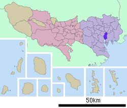
 Chūō
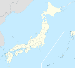
ChūōCoordinates: 35°40′N 139°46′E / 35.667°N 139.767°ECoordinates: 35°40′N 139°46′E / 35.667°N 139.767°E Country Japan Region Kantō Prefecture Tokyo Government - Mayor Yoshihide Yada Area - Total 10.15 km2 (3.9 sq mi) Population (2008) - Total 108,943 - Density 9,654/km2 (25,003.7/sq mi) Time zone Japan Standard Time (UTC+9) Website Chuo Chūō (中央区 Chūō-ku) is one of the 23 special wards that form the heart of Tokyo, Japan. The ward refers to itself as Chūō City in English.
Its Japanese name literally means "Central Ward," and it is historically the main commercial center of Tokyo, although Shinjuku has risen to challenge it since the end of World War II. The most famous district in Chūō is Ginza (銀座), built on the site of a former silver mint from which it takes its name. The gold mint, or Kinza (金座), formerly occupied the site of the present-day Bank of Japan (日本銀行) headquarters building, also in Chūō.
As of 2008, the ward has an estimated resident population of 108,943 and a density of 9654 persons per km². However, because of the concentration of businesses, offices and retail space, the daytime population swells to an estimated 650,000.
Contents
Geography
Chūō is in the central area of Tokyo, surrounded by the five special wards of Chiyoda, Minato, Taito, Sumida, and Kōtō.
Administratively, Chūō is divided into the three zones of Nihonbashi, Kyobashi and Tsukishima. Nihonbashi and Kyobashi are predominantly commercial areas on the east side of Tokyo Station, and incorporate the famous districts of Ginza and Tsukiji. Tsukishima is a separate island in Tokyo Bay dominated by condominium towers.
Until World War II, the area was criscrossed by small rivers and canals, used by small boats which were the primary vehicles of commerce at the time. After the war, many of these waterways were filled in to make way for new roads, buildings and expressways. However, the former waterways are the basis for many of the neighborhood divisions in the ward. The Sumida River forms the eastern boundary of the ward.
Chūō is physically the second-smallest ward in Tokyo, with a total area of just 10.15 km²; only Taito is smaller.
History
- 1612: Shogun Tokugawa Ieyasu, planning to establish Edo as the de facto capital of Japan, begins work on a new commercial district surrounding the eastern end of the Tōkaidō, the main road connecting Tokyo and the Kansai region. During the Edo period this area is known as Edomachi - the town center of Edo. Much of the area (particularly Ginza and Tsukiji) was loose sand piled at the delta of the Sumida River before being filled in by the shogunate.
- 1657: After a fire consumes much of the city, the area is re-planned with more canals to accommodate more maritime commerce.
- 1869: A foreigners' settlement is established in Tsukiji. It continues until about 1899.
- 1872: A fire consumes much of the Ginza area. In its aftermath, the governor of Tokyo re-plans Ginza to be a modern European-style commercial district between Shinbashi (the city's main railway terminal at the time) to the south and Nihonbashi (the main business and financial district) to the north.
- 1878: Under a new local organization statute, the wards of Nihonbashi and Kyobashi are established under the government of Tokyo City, covering the area now occupied by Chūō.
- 1945: Following Japan's defeat in World War II, several buildings are taken over by SCAP to serve as supply centers for the occupation forces. These include the Hattori Watch Company, the Matsuya department store and the Toshiba Building. The buildings are returned to Japanese civilian control by 1951.
- 1947: Chūō Ward is founded on March 15 under the new Local Autonomy Law, merging the former Nihonbashi and Kyobashi wards.
Places
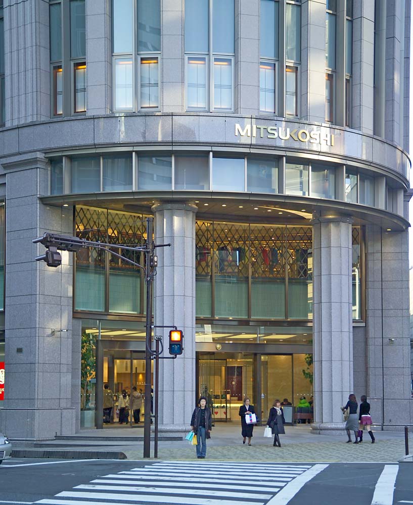
 Mitsukoshi Department Store
 Tsukiji Hongwanji
- Nihonbashi Area (日本橋地区)
- Hakozakicho (箱崎町) - Location of Tokyo City Air Terminal (T-CAT)
- Hamacho (浜町)
- Hisamatsucho (久松町)
- Higashi-nihonbashi (東日本橋)
- Honcho (本町)
- Hongokucho (本石町) - Location of Bank of Japan (日本銀行).
- Horidomecho (堀留町)
- Kabutocho (兜町) - The securities district. Location of Tokyo Stock Exchange.
- Kakigaracho (蛎殻町)
- Suitengu Shrine (水天宮) - A Shinto shrine at which women pray for conception and safe birth.
- Kayabacho (茅場町)
- Kodenmacho (小伝馬町)
- Muromachi (室町) - Location of Mitsukoshi (三越) department stores.
- Nihonbashi (日本橋) - Traditional commercial center. Also home to the Takashimaya (高島屋) department stores, and the "zero milestone" from which highway distances to Tokyo are measured.
- Ningyocho (人形町)
- Ohdenmacho (大伝馬町)
- Tomizawacho (富沢町)
- Yokoyamacho (横山町)
- Kyōbashi Area (京橋地区)
- Akashicho (明石町) - Home to St. Luke's Hospital and Nursing School and the adjacent Garden Tower skyscraper.
- Ginza (銀座) - Tokyo's most expensive shopping district, housing large stores such as Matsuya (松屋), Matsuzakaya (松坂屋), Mitsukoshi (三越), Wako (和光), and Printemps (プランタン), as well as the famous Kabukiza (歌舞伎座) theater. At night, Ginza is ablaze with neon lights. Exclusive bars abound.
- Shinbashi Enbujo (新橋演舞場) - A famous theater
- Hatchobori (八丁堀) - During the Edo period, the location of the police barracks
- Hamarikyu-teien (浜離宮庭園) - Location of Hamarikyu Onshi Teien (浜離宮恩賜庭園). A spacious public park, formerly the property of daimyo of Kōshū, and later under the administration of the Imperial Household Agency
- Kyobashi (京橋)
- Minato (湊)
- Shinkawa (新川)
- Eitai Bridge (永代橋) - A bridge across the Sumida River (隅田川)
- Shintomi (新富)
- Tsukiji (築地) - Location of Chuo City Office. Widely viewed as one of the best sushi (寿司) destinations in the world because of its huge wholesale fish market, which supplies restaurants and stores across eastern Japan. Also home to the Jodo Shinshu temple of Tsukiji Hongwanji (築地本願寺).
- Yaesu (八重洲) - District on the east side of Tokyo Station(東京駅). The Yaesu side of Tokyo Station is the terminal for the Shinkansen (新幹線), or "bullet train" lines.
- Tsukishima Area (月島地区)
- Harumi (晴海) - the Harumi passenger terminal is here
- Kachidoki (勝どき) - The location of a bridge of the same name over the Sumida River
- Tsukishima (月島)
- Tsukuda (佃)
- Sumiyoshi Shrine (住吉神社) - A Shinto shrine with a history dating back to 1590
- Toyomicho (豊海町)
Economy
 Ricoh Building
 Ajinomoto headquarters
Ricoh is headquartered in the Ricoh Building in Chūō.[1] In 2006 Ricoh's headquarters to the 25-story building in the Ginza area in Chūō from Minato, Tokyo; in the building the headquarters occupies the same space as its sales offices.[2][3][4] Sumitomo is headquartered in the Harumi Island Triton Square Office Tower Y in Chūō.[5] J. Front Retailing has its headquarters in Yaesu.[6] Asahi Shimbun, Asatsu DK, and Nihon Ad Systems have their headquarters in Tsukiji.[7][8][9] Ajinomoto,[10] Mitsui Fudosan,[11] and Nomura Group are also headquartered in the ward.[12]
Orion Breweries and Takeda Pharmaceutical Company have their Tokyo-area offices in Chūō.[13][14][15]
Foreign operations
Tokyopop maintains its Japanese headquarters in Mid-Tower of the Tokyo Towers.[16] IBM has its Japan headquarters in Chūō.[17]
Former economic operations
Dai-ichi Kikaku Senden Co., Ltd. opened in Chūō in Ginza, Chūō in December 1951. In January 1958 the company relocated to a new headquarters in Ginza. The company moved to another headquarters in Ginza in September 1961 and its name changed to Dai-ichi Kikaku Co., Ltd. In November 1974, after growth, the company moved to another headquarters in Ginza. In November 1981 Dai-ichi Kikaku moved its head office to a facility in Ginza and a facility in Uchisaiwaichō, Chiyoda. The headquarters of Asatsu moved to Ginza in July 1995. Asatsu and Dai-ichi Kikaku merged into Asatsu-DK on January 1, 1999.[18]
In the late 1990s GeoCities Japan was headquartered in the Nihonbashi Hakozaki Building in Nihonbashi.[19]
Politics and government
Chuo is run by a city assembly of 30 elected members. The current mayor is Yoshihide Yada, an independent backed Liberal Democratic Party and Komeito.
Elections
Transportation
For more details on this topic, see Transportation in Greater Tokyo.Rail
At Tokyo Station, six Shinkansen, seven ordinary railway, and one subway line serve Chūō. In addition, three Toei subway lines stop at various stations throughout the ward.
Highway
- No. 1 Ueno Route (Edobashi JCT - Iriya)
- No. 6 Mukojima Route (Edobashi JCT - Horikiri JCT)
- No. 9 Fukagawa Route (Hakozaki JCT - Tatsumi JCT)
- C1 Inner Loop (Edobashi - Takaracho - Kyōbashi - Ginza - Shiodome - Hamazakibashi - Shiba Park - Tanimachi - Kasumigaseki - Daikanmachi - Edobashi)
Education
Public elementary and middle schools in Chūō are operated by the Chūō City Board of Education. Public high schools are operated by the Tokyo Metropolitan Government Board of Education.
See also
References
- ^ "Company Data." Ricoh. Retrieved on January 13, 2009.
- ^ "Topics - Annual Report 2006." Ricoh. Retrieved on January 13, 2009.
- ^ "Outline of Ricoh." Ricoh. May 16, 1997. Retrieved on January 13, 2009.
- ^ "Company Data." Ricoh. Retrieved on January 13, 2009.
- ^ "Corporate Profile." Sumitomo Corporation. Retrieved on January 26, 2009.
- ^ "Corporate Data." J. Front Retailing. Retrieved on December 15, 2010. "Office : 1-1, Yaesu 2-chome, Chuo-ku, Tokyo "
- ^ "会社概要." Asahi Shimbun. Retrieved on February 26, 2010.
- ^ "会社概要." Nihon Ad Systems. Retrieved on February 26, 2010.
- ^ "Relation." Asatsu DK. Retrieved on November 9, 2009.
- ^ "Toward the realization of "Ajinomoto Group Zero Emissions" Chuo Ace Logistics Corporation achieves "Green Management Certification" Chuo Ace Logistics Corporation promotes environmentally friendly logistics." Ajinomoto. Retrieved on February 12, 2010.
- ^ "Corporate Data." Mitsui Fudosan. Retrieved on May 19, 2009.
- ^ "Nomura Group." Nomura Group. Retrieved on May 30, 2010.
- ^ "会社概要 - オリオンビール." Orion Breweries. Retrieved on November 30, 2009. "東京営業所所在地 〒104-0032 東京都中央区八丁堀4丁目5-12 アインツビル1F"
- ^ "FAQ." Takeda Pharmaceutical Company. Retrieved on February 2, 2011. "Q : Where is Takeda located? A : [...] and the Tokyo Head Office is located in Tokyo, Japan."
- ^ "Overview." Takeda Pharmaceutical Company. Retrieved on February 2, 2011. "Tokyo Head Office 12-10, Nihonbashi 2-chome, Chuo-ku, Tokyo 103-8668"
- ^ "Contact Us." Tokyopop. Retrieved on July 23, 2009.
- ^ "IBM Japan." IBM. Retrieved on October 21, 2009.
- ^ "Corporate Overview." Asatsu-DK. Retrieved on November 9, 2009.
- ^ "スタッフ募集." GeoCities Japan. February 21, 1999. Retrieved on April 30, 2009.
External links
- Chuo official website in English
- Chuo official website in Japanese
- Chuo City Tourism Association in English
- Chuo City Tourism Association in Japanese
- Tokyo/Chuo travel guide from Wikitravel
Tokyo Metropolis Architecture · Education · Festivals · History · Politics · Sports · Tourism · Transportation Special Wards 

Cities Districts and
SubprefecturesPortal · Category Metropolitan cities of Japan Tokyo Metropolis Designated cities Core cities Akita · Amagasaki · Aomori · Asahikawa · Fukuyama · Funabashi · Gifu · Hakodate · Higashiōsaka · Himeji · Iwaki · Kagoshima · Kanazawa · Kashiwa · Kawagoe · Kōchi · Kōriyama · Kumamoto · Kurashiki · Kurume · Maebashi · Matsuyama · Miyazaki · Morioka · Nagano · Nagasaki · Nara · Nishinomiya · Ōita · Okazaki · Ōtsu · Shimonoseki · Takamatsu · Takasaki · Takatsuki · Toyama · Toyohashi · Toyota · Utsunomiya · Wakayama · YokosukaSpecial cities Akashi · Atsugi · Chigasaki · Fuji · Fukui · Hachinohe · Hirakata · Hiratsuka · Ibaraki · Ichinomiya · Isesaki · Jōetsu · Kakogawa · Kasugai · Kasukabe · Kawaguchi · Kishiwada · Kōfu · Koshigaya · Kumagaya · Kure · Matsumoto · Mito · Nagaoka · Neyagawa · Numazu · Odawara · Ōta · Sasebo · Sōka · Suita · Takarazuka · Tokorozawa · Tottori · Toyonaka · Tsukuba · Yamagata · Yamato · Yao · YokkaichiPrefectural capitals
(not included above)Categories:- Chūō, Tokyo
- Wards of Tokyo


Wikimedia Foundation. 2010.