- Bucksburn
-
Coordinates: 57°10′41″N 2°10′54″W / 57.178133°N 2.1816961°W
Bucksburn (Aberdeen) 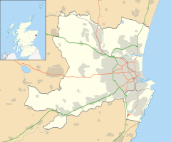
 Bucksburn (Aberdeen)
Bucksburn (Aberdeen) shown within the City of AberdeenPopulation 7,232 [1] OS grid reference NJ 89114 09715 Council area Aberdeen Country Scotland Sovereign state United Kingdom Post town Aberdeen Postcode district AB21 9 Dialling code 01224 Police Grampian Fire Grampian Ambulance Scottish EU Parliament Scotland UK Parliament Aberdeen North Scottish Parliament Aberdeen Donside List of places: UK • Scotland • Aberdeen Coordinates: 57°10′47″N 2°11′12″W / 57.1798°N 2.1866°W
Bucksburn The old station and goods yard in 1961
Bucksburn is an area of the city of Aberdeen, Scotland, named after the stream that flows through it. Bucksburn was formerly a market village before being swallowed up by the spread of the city. It is now categorised as a "Neighbourhood" by Aberdeen City Council. Bucksburn is covered by three electoral wards for the Local Authority - "Newhills", "Bankhead/Stoneywood" and "Auchmill".
Politically, Bucksburn is in the Aberdeen North Constituency for the UK Parliament and in Aberdeen Donside for the Scottish Parliament.
The area is bordered by countryside - in particular Kirkhill Forest and the land surrounding Brimmond Hill.
Bucksburn has a world-class pipe band, Bucksburn & District Pipe Band. Formed in 1947, this band has won numerous titles and represented Aberdeen in many places including Spain, Taiwan, Canada and Belarus. The Band teaches piping & drumming through a Junior Band which was crowned Scottish, British and World Champions in 2008.
References
Areas of Aberdeen 
- See Areas of Aberdeen for a more complete list of the city's districts and areas.
Altens · Balnagask · Bieldside · Bridge of Dee · Bridge of Don · Broomhill · Bucksburn · Cornhill · Cove Bay · Cults · Danestone · Dyce · Footdee · Foresterhill · Garthdee · Hazlehead · Hilton · Kincorth · Kingswells · Kittybrewster · Mannofield · Mastrick · Midstocket · Milltimber · Nigg · Northfield · Old Aberdeen · Peterculter · Queen's Cross · Rosemount · Rubislaw · Summerhill · Tillydrone · Torry · Tullos · Woodside
Categories:- Areas of Aberdeen
- Aberdeen geography stubs


Wikimedia Foundation. 2010.