- Lumber River
-
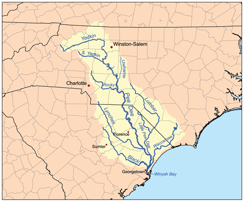
 Map of the Pee Dee River watershed showing the Lumber River.
The Lumber River is a 133-mile-long (214 km)[1] river in south-central North Carolina in the flat Coastal Plain. European settlers first called the river Drowning Creek, which still is the name of its headwater. The waterway known as the Lumber River extends downstream from the Scotland County-Hoke County border to the North Carolina-South Carolina border. Soon after crossing into South Carolina, the Lumber River flows into the Little Pee Dee River, which flows into the Pee Dee River, or Great Pee Dee River. Finally, the combined waters flow into Winyah Bay and the Atlantic Ocean.
In 1989, the river was designated as a "Natural and Scenic River" by the North Carolina General Assembly. In addition, it is the only blackwater river in North Carolina to be designated as a National Wild and Scenic River by the Department of Interior. In 2010, the Lumber River was voted one of North Carolina’s Ten Natural Wonders, the result of an on-line contest held by Land for Tomorrow, a coalition dedicated to supporting the preservation of North Carolina’s land and water resources.[2]
In 2009, leaders of the state-recognized Lumbee tribe, based in Robeson County, North Carolina, passed an internal resolution asking the legislature to change the name of the river to Lumbee, to reflect their population in the region. They plan to ask their state representative to submit a bill to this effect.[3]
Contents
History
Pre-European contact period
A number of archaeological sites have been excavated on high ground along the river. While most have been disturbed by the agricultural and forestry practices of the post-Columbian era, isolated artifacts and fossils have been recovered. These include a dugout canoe made by indigenous people and estimated to be over 1,025 years old. This ancient canoe is on display at the University of North Carolina at Pembroke.
Much of the archaeological work in the Lumber River region has been done in Robeson County. A total of 429 archaeological sites have been recorded in this area. Each site is classified under one of four categories: Paleo-Indian, Archaic Woodland, Mississippian and Historic (after European encounter). Iroquoian, Siouan, and Carolina Algonquian-speaking peoples were among the historic tribes who lived in the coastal region prior to European encounter. Archeologists have identified 47 sites of potential importance, 20 of which have been nominated to the National Register of Historic Places.
Eighteenth century
Early English surveyors named the river "Drowning Creek." In 1749, British colonial records identified the river as a branch of the Little Pee Dee River. In 1809, the North Carolina state legislature changed the name of the river to Lumber, most likely to symbolize the thriving lumber industry in the area, and its use of the river for transporting logs. They wanted a name more positive than Drowning Creek.
Nineteenth century
In the late 18th and the 19th centuries, the lumbering and naval stores industries were critical to the region's economy. The Lumber River became a vital route for transporting 100-foot logs downriver to Georgetown, South Carolina. Lumberton, North Carolina served as an important turpentine and timber town. Bridge abutments, tram bridges, and dock pilings are reminders of the critical importance of lumbering and naval stores industries to the area as a whole.
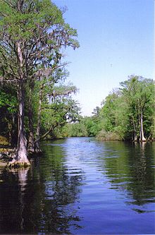 The Lumber River as seen from the boat launch at Princess Ann near Orrum. Note the spanish moss on the cypress trees.
Recreation
Currently, the Lumber River is a highly prized recreation corridor in North Carolina. Active outdoor recreation and festivals are among the most popular activities, including canoeing, boating, fishing, hunting, picnicking, camping, nature study, swimming, biking, jogging, crafts, and fossil and artifact hunting.
Lumber River State Park
The Lumber and some of its adjoining banks are part of the Lumber River State Park, which comprises 9,874 acres of land and 115 miles of waterway. The park’s recreational activities are currently at Princess Ann Access in the south and the Chalk Banks access to the north (near the town of Wagram).[4]
There are 24 boat launches along the Lumber River that serve as access points to Lumber River State Park. The entire length of the river is open to fishing. The common game fish are black crappie, largemouth bass, catfish and redbreast sunfish. All anglers must have a valid fishing license and follow the regulations of the North Carolina Wildlife Resources Commission. Nine primitive camping sites are located at the Princess Ann section of the park, between Orrum and Fair Bluff. These campsites are meant to be used by no more than 6 people at a time. Each camp site features, a picnic table and grill, lantern holder, trash can, and fire ring. There are several hiking trails and picnic areas at Princess Ann as well as the many municipal and county parks that are located on the Lumber River.[5]
Fourteen individual campsites are available at the Chalk Banks Access Area in Scotland County for family camping. Each site has a table, lantern holder, trash can and fire pit. Canoe-in campsites are also available.
References
- ^ "The National Map". U.S. Geological Survey. http://viewer.nationalmap.gov/viewer/. Retrieved Feb. 14, 2011.
- ^ http://www.robesonian.com/view/full_story/7549682/article-River-Quest--Lumber-makes-list-of-top-10-state-wonders?instance=home_news_lead
- ^ Jenkins, Venita (July 4, 2009). "Lumbees want river renamed". The Fayetteville Observer. http://www.fayobserver.com/Articles/2009/07/04/914306. Retrieved 2009-07-04.[dead link]
- ^ chalkbanks.com
- ^ "Lumber River State Park". North Carolina Department of Environment and Natural Resources. http://www.ncparks.gov/Visit/parks/luri/main.php. Retrieved 2007-04-11.
External links
Coordinates: 34°11′44″N 79°09′56″W / 34.1954414°N 79.1655961°W
Categories:- Rivers of North Carolina
- Protected areas of Scotland County, North Carolina
- Protected areas of Hoke County, North Carolina
- Protected areas of Robeson County, North Carolina
- Protected areas established in 1989

Wikimedia Foundation. 2010.