- Nuussuaq
-
For other uses, see Nuussuaq (disambiguation).
Nuussuaq Wooden houses in Nuussuaq Location within Greenland
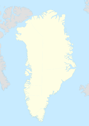
 Nuussuaq
Coordinates: 74°06′40″N 57°03′40″W / 74.11111°N 57.06111°WCoordinates: 74°06′40″N 57°03′40″W / 74.11111°N 57.06111°W State  Kingdom of Denmark
Constituent country  Greenland
Municipality Qaasuitsup Founded 1923 Population (2010) - Total 204 Time zone UTC-03 Postal code 3962 Upernavik Nuussuaq (old spelling: Nûgssuaq, Danish: Kraulshavn) is a settlement in the Qaasuitsup municipality in northwestern Greenland. It is the only mainland settlement in the Upernavik Archipelago, located near the western tip of the Nuussuaq Peninsula, on the northern coast of Sugar Loaf Bay, an indentiation of Baffin Bay.
The settlement was founded in 1923 as a trading station, growing in size during the post-war consolidation phase, when hunters from several small villages in the region of neighboring Inussulik Bay, Sugar Loaf Bay, and Tasiusaq Bay moved into the larger settlements such as Nuussuaq and Kullorsuaq further north in Melville Bay. Today Nuussuaq remains one of the most traditional hunting and fishing villages in Greenland, with a stable population.
Contents
History
 Dogsleds remain the means of transport in the winter
Prehistory
The Upernavik Archipelago belongs to the earliest-settled areas of Greenland; the first migrants arriving approximately 2,000 years BCE[1] All southbound migrations of the Inuit passed through the area, leaving behind a trail of archeological sites.[2] The early Saqqaq culture diminished in importance around 1.000 BCE, followed by the migrants of Dorset culture, who spread alongside the coast of Baffin Bay,[1] being in turn misplaced by the Thule people in the 13th and 14th centuries. The archipelago has been continuously inhabited since then.
20th century
Nuussuaq was founded in 1923 as a trading post, during the modern northbound migration of Greenlanders from Upernavik.[3] The settlement was initially populated by hunters from the now abandoned villages of the region: Kuuk, Itissaalik (abandoned in 1957), and Ikermiut (abandoned in 1954).[3] Not all of the initial wave of settlers from these villages of fewer than 10 people remained in Nuussuaq, but by the end of the 1920s, other families arrived in place of the hunters who moved north to Kullorsuaq in Melville Bay, and the community began to slowly grow.[3]
Between 1930 and 1960, northwestern Greenland underwent a consolidation phase, driven by the Danish colonial authorities via Royal Greenland, then part of KNI, with a countrywide monopoly on trade. The mutual agreement between the hunting families and the trade company limited the pre-war northward expansion until the 1950s, when the populations of the smaller settlements reinforced larger communities in Nuussuaq and Kullorsuaq, where the physical limit of uninhabitable Melville Bay presented a natural barrier to expansion.[3] Today Nuussuaq remains one of the most traditional hunting and fishing villages in Greenland.
Geography
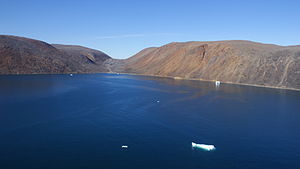 Protected inlet
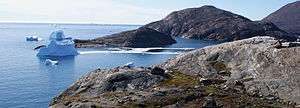 The gates to the inlet: Qallunaaq Arnaq (western spur) seen from Nuussuaq Heliport (eastern spur)Nuussuaq's inlet of Sugar Loaf Bay
Nuussuaq is located in the northern part of Upernavik Archipelago, a vast archipelago of small islands on the coast of northeastern Baffin Bay.[4] The settlement straddles a small rock spur jutting off Nuussuaq Peninsula, on the northern coast of Sugar Loaf Bay, an indentiation of Baffin Bay.[4] The name of both the settlement and the peninsula means "a large tip" in the Greenlandic language.
Nuussuaq is the only mainland settlement between Ukkusissat in the Uummannaq Fjord region and Savissivik near Cape York, at the northern end of Melville Bay. All other settlements of the archipelago are insular.[4][5]
The rock spur off Nuussuaq Peninsula encloses a small inlet of Sugar Loaf Bay from the south, met by another spur in the west, nearly closing off the inlet, with a small island between the two spurs. The inlet provides good harbourage and protection from the open waters of Baffin Bay, a deciding factor for the foundation of the settlement.[3] The western spur is called "Qallunaaq Arnaq" (old spelling: Qavdlunâq Arnaq)[4] − literally: "Danish Woman" in the Greenlandic language − named so for its shape resembling brassiere, at one time a novelty. The name is not unique to the region: an identically named hill of similar shape is located in western Greenland, east of Sisimiut, on the shores of Ikertooq Fjord.[6]
The protection offered by the inlet is complemented by several factors facilitating settlement: two freshwater lakes are located immediately to the east of the village, while the southern coast of Nuussuaq Peninsula is protected from northward winds in the winter. The short distance (6.8 km (4.2 mi)) from Nuussuup Nuua − the western cape of the 52 km (32 mi) long Nuussuaq Peninsula − placed the settlement on the old maritime route from Upernavik, through the islands of Tasiusaq Bay, to Kullorsuaq in Melville Bay.[3]
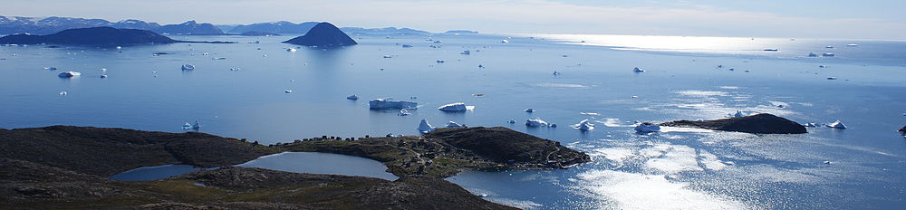 Sugar Loaf Bay seen from the ridge of Nuussuaq Peninsula: freshwater lakes, Nuussuaq settlement on the coast, Sugar Loaf Island in the far center, and open Baffin Bay in the west (right).
Economy
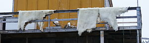 Tradition: a hunter's house with drying polar bear skins
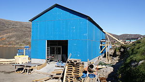 Organized labor: a fish processing factoryTraditional versus modern occupation
Hunting and fishing are the mainstay of the area,[1] although the more northern settlements still rely on traditional hunting of fur seals, walruses, and whales to supplement the family economy. In that, the northern region is culturally linked with the far north of Greenland (Kalaallisut: Avannarsuaq), the Qaanaaq region.
Outside of Upernavik town, the average level of income in the archipelago is amongst the lowest in Greenland. Alongside three other settlements in the archipelago (Naajaat, Kullorsuaq, and Upernavik Kujalleq), Nuussuaq is listed in the top 10 poorest within Greenland.[7]
On 28 August 2010, a fish processing factory of Upernavik Seafood was opened in Nuussuaq, joining the set of 8 other such factories in the Upernavik Archipelago.[8] Apart from the communal all-purpose Pilersuisoq store, the factory is the first business enterprise in the settlement.
Transport
Main article: Nuussuaq HeliportAir Greenland serves the village as part of government contract, with twice-weekly helicopter flights to Kullorsuaq and Upernavik.[9]
Population
In 2010, Nuussuaq had 204 inhabitants.[10] The population of the settlement has slowly increased over the last two decades, reflecting the trend in the neighboring Kullorsuaq.[10]
 Nuussuaq population growth dynamics in the last two decades. Source: Statistics Greenland[10]
References
- ^ a b c "History". Upernavik Tourist Service. http://www.greenland-guide.gl/upernavik/history.htm. Retrieved 4 September 2010.
- ^ O'Carroll, Etain (2005). Greenland and the Arctic. Lonely Planet. pp. 196–199. ISBN 1-74059-095-3.
- ^ a b c d e f Petersen, Robert (2003). Settlements, kinship and hunting grounds in traditional Greenland: A comparative study of local experiences from Upernavik and Ammassalik. Danish Polar Center. pp. 104–108, 230. ISBN 978-87-635-1261-9.
- ^ a b c d Upernavik Avannarleq, Saga Map, 1:250.000, Tage Schjøtt, 1992
- ^ Upernavik, Saga Map, 1:250.000, Tage Schjøtt, 1992
- ^ Greenland Tourism a/s. Vandrekort Vestgrønland: Pingu (Map). Cartography by Compukort, Denmark (1996 ed.).
- ^ "Bygderne skal selv tage ansvar" (in Danish). Sermitsiaq. 17 April 2010. http://www.sermitsiaq.gl/indland/article81717.ece. Retrieved 28 August 2010.
- ^ "Så fik Nuussuaq sin fabrik" (in Danish). Sermitsiaq. 28 August 2010. http://sermitsiaq.ag/indland/article127971.ece. Retrieved 28 August 2010.
- ^ "Booking system". Air Greenland. http://book.airgreenland.com/. Retrieved 10 July 2010.
- ^ a b c "Population in localities January 1.st by locality, age, gender and place of birth 1977-2010". Statistics Greenland. http://bank2.stat.gl/dialog/varval.asp?ma=BEEST4&ti=Population+in+localities+January+1%2Est+by+locality%2C+age%2C+gender+and+place+of+birth+1977%2D2010&path=../Database/Greenland/Population/Population%20in%20Greenland/&search=NUUSSUAQ&lang=4. Retrieved 4 September 2010.
Upernavik Archipelago, Greenland Bays Fjords Eqalugaarsuit • Kangerluarsuk • Kangerlussuaq (Kangeq Peninsula) • Kangerlussuaq Icefjord • Nasaussap Saqqaa • Nuussuup Kangia • Saqqarsuaq • Sullua • Tasersuatsiaq • Upernavik IcefjordGlaciers Alanngorsuup Sermia • Cornell • Giesecke • Hayes • Illullip Sermia • Kjer • Nunatakassaup Sermia • Nunatakassaup Sermia (Tasiusaq Bay) • UpernavikHeadlands Cape Shackleton • Nuussuup Nuua • Wilcox HeadIslands Melville BayKiatassuaq • Kiataussaq • Kullorsuaq • Saarlia • SaqqarlersuaqInussulik BayIkermiut • Illoorfik • Inussullissuaq • KiatassuaqSugar Loaf BayAmitsorsuaq • Ikermiorsuaq • Itissaalik • Kittorsaq • Nasaussaq • Qullikorsuit • Sugar Loaf • TimilersuaTasiusaq BayAappilattoq • Anarusuk • Apparsuit • Ateqanngitsorsuaq • Aukarnersuaq • Horse Head • Illunnguit • Innaarsuit • Kangaarsuk • Maniitsoq • Mattaangassut • Mernoq • Naajaat • Nuuluk • Nutaarmiut • Paagussat • Paornivik • Puugutaa • Qaarsorsuatsiaq • Qallunaat • Qaneq • Qaqaarissorsuaq • Qullikorsuit • Saattorsuaq • Sisuarissut • Tasiusaq • Tussaaq • Tuttorqortooq • UigorlersuaqBaffin BayAappilattoq • Akia • Akuliaruseq • Amarortalik • Ammaussarsuaq • Atilissuaq • Iperaq • Karrat • Kingittorsuaq • Nako • Nunaa • Nutaarmiut • Qaarsorsuaq • Qasse • Qeqertaq • Qeqertarsuaq • Saattoq • Sanningassoq • Singarnaq-Annertussoq • Taartoq • Tukingassoq • Uilortussoq • UpernavikMountains/Nunataqs Akullikassaq • Anoritooq • Devil's Thumb • Inalugartuut • Inngik • Iviannernat • Kangerluarsuup Qaqqarsua • Kingittoq • Kissavaussaq • Kunngutip Qaqqaa • Naajannguaq • Naalungiussaq • Najaarsuit Qaqqat • Niaqornarsuaq • Nunatakassak • Nunatarsuaq • Nunatarsuaq (Tasiusaq Bay) • Nuniaat Qaqqarsua • Orsugissap Qaqqarsua • Paatuup Qaqqaa • Qaqqasunnarsuaq • Qassersuit • Saattup Akia • Sandersons Hope • Sisuarsuit • Toornaarsuttoq • Tunullersuaq • Tuttulikassak • Umiasussuk • Wandel LandPeninsulas Straits Akornat • Ammarqua • Appaalissiorfiup Ikerasaa • Ikerasaa • Ikerasak • Ikerasakassak • Ikerasassuaq • Qassersuit Saqqaa • Saqqarlersuup Sullua • Simiuttap Ikerasaa • TorsukattakTowns/Settlements Aappilattoq • Kangersuatsiaq • Kullorsuaq • Innaarsuit • Naajaat • Nutaarmiut • Nuussuaq • Tasiusaq • Upernavik • Upernavik KujalleqCategories:- Populated places in Greenland
- Populated places of Arctic Greenland
- Sugar Loaf Bay
- Upernavik Archipelago


Wikimedia Foundation. 2010.