- National Register of Historic Places listings in Rockland County, New York
-
 Location of Rockland County in New York
List of the National Register of Historic Places listings in Rockland County, New York
This is intended to be a complete list of properties and districts listed on the National Register of Historic Places in Rockland County, New York. The locations of National Register properties and districts (at least for all showing latitude and longitude coordinates below) may be seen in a Google map by clicking on "Map of all coordinates".[1] There are three properties and districts that are further designated U.S. National Historic Landmarks.
-
- This National Park Service list is complete through NPS recent listings posted November 18, 2011.[2]
Contents: Counties in New York Albany (Albany) – Allegany – Bronx – Broome – Cattaraugus – Cayuga – Chautauqua – Chemung – Chenango – Clinton – Columbia – Cortland – Delaware – Dutchess – Erie (Buffalo) – Essex – Franklin – Fulton – Genesee – Greene – Hamilton – Herkimer – Jefferson – Kings (Brooklyn) – Lewis – Livingston – Madison – Monroe (Rochester) – Montgomery – Nassau – New York (Manhattan – Below 14th Street, 14th to 59th Streets, 59th to 110th Streets, Above 110th Street, Islands) – Niagara – Oneida – Onondaga (Syracuse) – Ontario – Orange – Orleans – Oswego – Otsego – Putnam – Queens – Rensselaer – Richmond (Staten Island) – Rockland – Saratoga – Schenectady – Schoharie – Schuyler – Seneca – St. Lawrence – Steuben – Suffolk – Sullivan – Tioga – Tompkins – Ulster – Warren – Washington – Wayne – Westchester (New Rochelle, Peekskill, Yonkers) – Wyoming – Yates Listings county-wide
[3] Landmark name Image Date listed Location City or town Summary 1 Maj. John Andre Monument 
November 8, 2006 42 Andre Hill
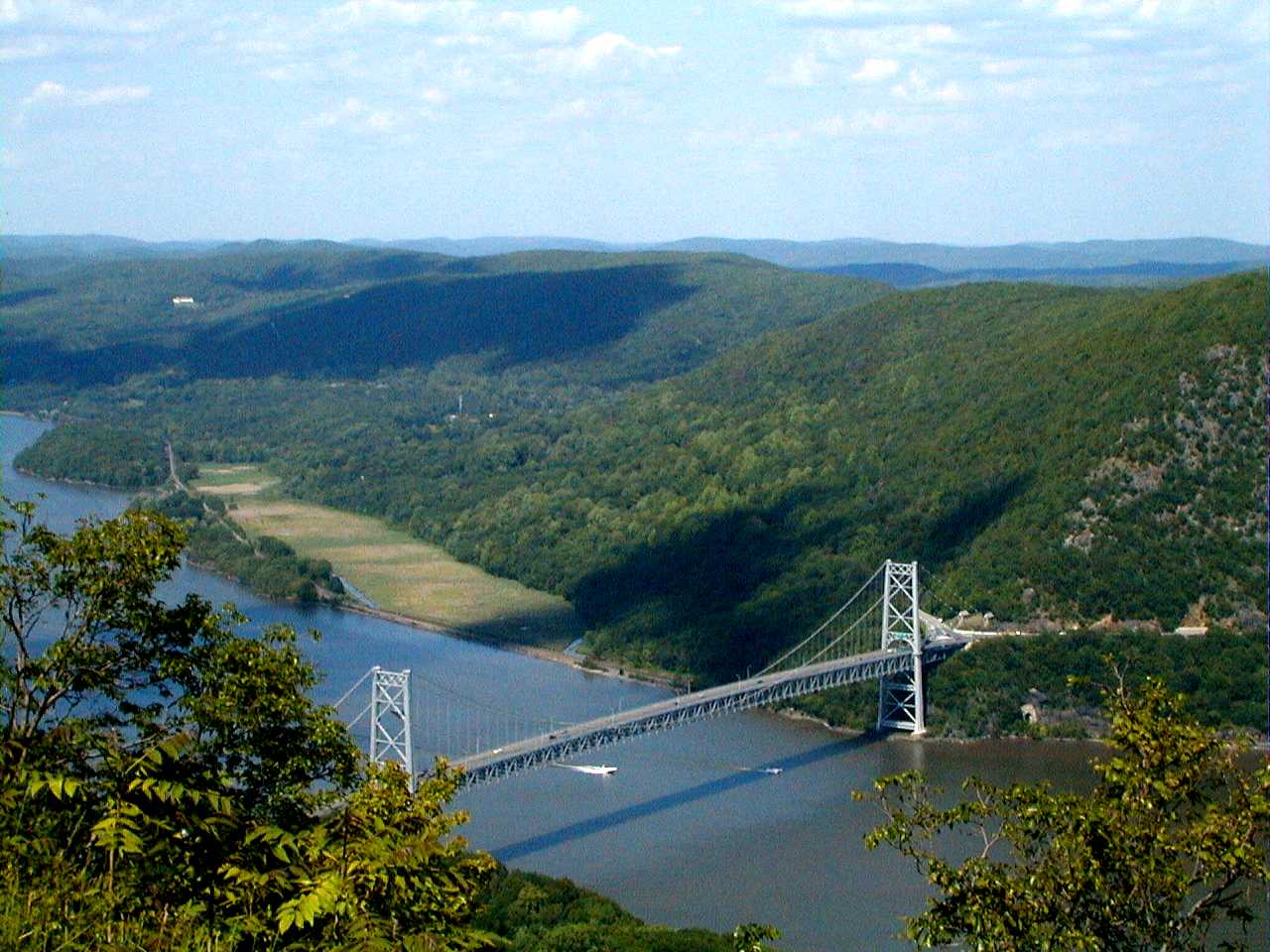
41°01′17″N 73°57′19″W / 41.021389°N 73.955278°WTappan Memorial to Major John André 2 Bear Mountain Bridge 
November 23, 1982 NY 6/202
41°19′12″N 73°58′49″W / 41.32°N 73.980278°WStony Point First crossing of Hudson north of New York City; built 1924 by Harriman family and later turned over to state 3 Bear Mountain Inn 
September 20, 2002 Seven Lakes Drive
41°18′47″N 73°59′25″W / 41.313056°N 73.990278°WBear Mountain 1915 rustic lodge was among first improvements to Bear Mountain State Park 4 Big House July 12, 1990 US 9W near jct. with Closter Rd.
41°00′45″N 73°54′47″W / 41.0125°N 73.913056°WPalisades 5 Blauvelt House March 28, 1985 Zukor Rd.
41°10′16″N 73°59′13″W / 41.171°N 73.987°WNew City 6 Brick Church Complex September 7, 1984 Brick Church Rd. and NY 306
41°08′25″N 74°03′55″W / 41.140278°N 74.065278°WNew Hempstead 7 Brook Chapel Brook ChapelFebruary 14, 2010 6th St.
41°07′29″N 74°10′35″W / 41.124722°N 74.176389°WHillburn refnum 09001287 8 Christ Church Christ ChurchMay 18, 2011 416 Valentine Ave.
41°01′48″N 73°55′34″W / 41.03°N 73.926111°WSparkill refnum 11000291 9 Cliffside July 12, 1990 Lawrence Ln. S of River Rd.
41°00′28″N 73°54′14″W / 41.007778°N 73.903889°WPalisades 10 Closter Road-Oak Tree Road Historic District July 12, 1990 Roughly, N side of Closter Rd. and S side of Oak Tree Rd. approx. 1/2 mi. W of US 9W
41°00′43″N 73°55′03″W / 41.011944°N 73.9175°WPalisades 11 Abner Concklin House August 6, 1987 Closter Rd.
41°00′26″N 73°55′14″W / 41.007222°N 73.920556°WPalisades 12 Contempora House April 29, 2009 88 S. Mountain Rd.
41°10′58″N 74°01′03″W / 41.182828°N 74.017481°WNew City 13 De Wint House 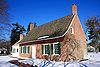
October 15, 1966 Livingston Ave. and Oak Tree Rd.
41°01′11″N 73°56′47″W / 41.019722°N 73.946389°WTappan Oldest house in county. Site of John André spy trial during Revolutionary War; visited by George Washington 14 John A. DeBaun Mill September 2, 1993 NY 59, N side, opposite Highview Ave.
41°06′45″N 74°06′16″W / 41.1125°N 74.104444°WTallman 15 Peter DePew House July 3, 2008 101 Old Route 304
41°10′13″N 73°58′39″W / 41.170278°N 73.9775°WNew City refnum 08000596 16 Dederer Stone House-Stonehurst December 31, 2002 82 Rockland Rd.
41°01′53″N 73°55′20″W / 41.031389°N 73.922222°WOrangetown 17 English Church and Schoolhouse 
November 23, 1977 484 New Hempstead Rd.
41°08′59″N 74°01′58″W / 41.149722°N 74.032778°WNew City 1827 Federal-style church built for first English congregation established in New York west of Hudson a century earlier is second-oldest church in county. 1863 schoolhouse was in use as a public school building for over a century. 18 William Ferdon House William Ferdon HouseMay 18, 2011 270 Ferdon Ave.
41°02′06″N 73°55′08″W / 41.035°N 73.918889°WPiermont vicinity refnum 11000292 19 First Methodist Episcopal Church of Nyack February 20, 1998 North Broadway, S of jct. of North Broadway and Birchwood Ave.
41°06′12″N 73°55′04″W / 41.103333°N 73.917778°WUpper Nyack 20 Fraser-Hoyer House April 22, 1976 Treason Hill off U.S. 9W
41°12′41″N 73°59′17″W / 41.211389°N 73.988056°WWest Haverstraw 21 Haddock's Hall June 20, 1991 300 Ferdon Ave.
41°02′07″N 73°55′08″W / 41.035278°N 73.918889°WPiermont 22 Haring-Eberle House July 12, 1990 US 9W N of Oak Tree Rd.
41°00′43″N 73°54′45″W / 41.011944°N 73.9125°WPalisades 23 The Homestead 
November 10, 1983 143 Hudson Ave.
41°11′36″N 73°58′00″W / 41.193333°N 73.966667°WVillage of Haverstraw Farmhouse built ca. 1800 is one of oldest buildings in Haverstraw; residence of former mayor and other officials 24 Houser-Conklin House Houser-Conklin HouseOctober 1, 2010 246 Route 306
41°08′05″N 74°04′00″W / 41.134722°N 74.066667°WMonsey vicinity refnum 10000808 25 Edward Hopper Birthplace and Boyhood Home 
April 6, 2000 82 North Broadway
41°05′35″N 73°55′06″W / 41.093056°N 73.918333°WNyack 26 Hopson-Swan Estate November 23, 1992 US 9W E of Sparkill, Tallman Mountain State Park
41°01′37″N 73°54′59″W / 41.026944°N 73.916389°WSparkill 27 Kings Daughters Public Library 
August 9, 1991 Jct. of Main and Allison Sts.
41°11′47″N 73°57′39″W / 41.196389°N 73.960833°WVillage of Haverstraw Recently renovated 1903 building was home to oldest chartered public library in county (now a branch) 28 Ladentown United Methodist Church September 7, 2005 Ladentown Rd.
41°11′07″N 74°04′05″W / 41.185278°N 74.068056°WPomona 29 Little House July 12, 1990 US 9W N of Oak Tree Rd.
41°00′43″N 73°54′45″W / 41.011944°N 73.9125°WPalisades 30 M/V COMMANDER September 27, 1984 Haverstraw Marina
41°13′52″N 73°58′32″W / 41.231111°N 73.975556°WVillage of Haverstraw 31 Carson McCullers House July 14, 2006 131 S. Broadway
41°05′09″N 73°55′11″W / 41.085833°N 73.919722°WSouth Nyack 32 Mount Moor African-American Cemetery August 29, 1994 Dexter Rd., off NY 54A
41°05′47″N 73°57′33″W / 41.096389°N 73.959167°WWest Nyack 33 Neiderhurst July 12, 1990 Ludlow Ln. S of River Rd.
41°00′35″N 73°54′29″W / 41.009722°N 73.908056°WPalisades 34 North Main Street School 
February 28, 2008 185 N. Main St.
41°07′22″N 74°02′36″W / 41.122778°N 74.043333°WSpring Valley One of the earliest modern school buildings in the county, built in 1916 and expanded several times since. Now a satellite campus of Rockland Community College. 35 Old Sloatsburg Cemetery 
July 23, 1999 Richards Rd.
41°09′13″N 74°11′48″W / 41.153611°N 74.196667°WSloatsburg Graves from late 18th to mid-20th centuries, including Sloat family members. Landscaping reflects different eras of cemetery design. 36 Onderdonk House September 28, 2006 748 Piermont Ave.
41°02′51″N 73°55′09″W / 41.0475°N 73.919167°WPiermont 37 Palisades Interstate Park 
October 15, 1966 W bank of the Hudson River
40°57′19″N 73°55′54″W / 40.955278°N 73.931667°WFort Lee and vicinity Extends through several NY and NJ counties. 38 Henry M. Peck House November 2, 2000 US 9W at Helen Hayes Hospital
41°12′44″N 73°59′18″W / 41.212222°N 73.988333°WWest Haverstraw 39 Jacob P. Perry House 
July 3, 2003 15 Sickeletown Rd.
41°03′16″N 73°59′28″W / 41.054444°N 73.991111°WPearl River House dating from turn of 19th century is one of last built in pre-Revolutionary Dutch Colonial style. 40 Philadelphia Toboggan Company Carousel Number 15 June 8, 2001 1000 Palisades Center
41°05′48″N 73°57′22″W / 41.096667°N 73.956111°WWest Nyack Formerly located in the Palisades Center but was removed in the summer of 2009.[4] 41 Piermont Railroad Station 
December 3, 2008 50 Ash Street
41°02′30″N 73°55′06″W / 41.041539°N 73.918464°WPiermont refnum #08001146 42 Henry Varnum Poor House December 11, 2007 S. Mountain Rd.
41°11′01″N 74°00′59″W / 41.183611°N 74.016389°WNew City 43 Rockland County Courthouse and Dutch Gardens January 3, 1991 Jct. of S. Main St. and New Hempstead Rd.
41°08′47″N 73°59′27″W / 41.146389°N 73.990833°WNew City 44 Rockland Road Bridge December 7, 2005 Rockland Rd., (bounded by Piermont and Ferdon Aves.)
41°02′06″N 73°55′10″W / 41.035°N 73.919444°WPiermont 45 Rockland Road Bridge Historic District Rockland Road Bridge Historic DistrictSeptember 29, 2011 Ferdon Ave., Rockland Rd. & S. Piermont Ave.
41°02′06″N 73°55′10″W / 41.035°N 73.919444°WPiermont refnum 11000709 46 William H. Rose House 
April 15, 1999 110 Tomkin Ave.
41°14′00″N 73°59′04″W / 41.233333°N 73.984444°WStony Point Picturesque house of local businessman built ca. 1862 moved from original nearby location 47 Ross-Hand Mansion September 8, 1983 122 S. Franklin St.
41°05′12″N 73°55′23″W / 41.086667°N 73.923056°WSouth Nyack 48 St. Paul's United Methodist Church March 12, 2001 S. Broadway and Division St.
41°05′13″N 73°55′22″W / 41.086944°N 73.922778°WNyack 49 St. Paul's Episcopal Church July 2, 2008 26 S. Madison Ave.
41°06′32″N 74°02′45″W / 41.108925°N 74.045886°WSpring Valley refnum 08000593 50 Edward Salyer House 
September 4, 1986 241 S. Middletown Rd.
41°03′04″N 74°00′51″W / 41.051111°N 74.014167°WPearl River Rare surviving Dutch Colonial frame house, built in 1765. Believed to be oldest house in Pearl River. 51 Michael Salyer Stone House 
December 31, 2002 Blue Hill Rd.
41°03′07″N 73°59′16″W / 41.051944°N 73.987778°WOrangetown 1790 house has clapboard infill at gambrel roof's apex, much more common for Ulster County stone houses. May reflect Huguenot influence during construction. 52 Seven Oaks Estate July 12, 1990 End of Ludlow Ln.
41°00′26″N 73°54′33″W / 41.007222°N 73.909167°WPalisades 53 Sloat House 
November 5, 1974 19 Orange Tpke.
41°09′02″N 74°11′38″W / 41.150556°N 74.193889°WSloatsburg Original 1755 home of Sloat family, added onto in 1810s. Has bullet holes from accidental shooting of John Sloat 54 Sloat's Dam and Mill Pond 
April 6, 2000 Off of Station Rd.
41°09′28″N 74°11′22″W / 41.157778°N 74.189444°WSloatsburg Only surviving dam of three on the upper Ramapo River dates to 1792. Powered Jacob Sloat's mills; used until 1955 55 Jacob Sloat House 
December 22, 2006 15 Liberty Rock Rd.
41°09′19″N 74°11′43″W / 41.155278°N 74.195278°WSloatsburg Also known as Harmony Hall. 1848 retirement home of local textile merchant who gave village its name illustrates transition from Greek Revival to Picturesque in American architecture. 56 Sparkill Creek Drawbridge 
March 28, 1985 Bridge St. over Sparkill Creek
41°02′14″N 73°54′58″W / 41.037222°N 73.916111°WPiermont 57 H. R. Stevens House 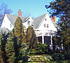
January 14, 2005 234 Congers Rd.
41°09′02″N 73°58′24″W / 41.150556°N 73.973333°WNew City 1775 house of locally quarried sandstone shows convergence of Dutch and English vernacular building traditions. Frame Federal style expansion done in 1820s. 58 Stony Point Battlefield 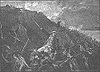
October 15, 1966 N of Stony Point on U.S. 2 and 202
41°14′32″N 73°58′25″W / 41.242222°N 73.973611°WStony Point 59 Stony Point Lighthouse 
May 29, 1979 Stony Point Battlefield
41°14′29″N 73°58′20″W / 41.241389°N 73.972222°WStony Point 60 Tappan Historic District 
April 26, 1990 Roughly bounded by Main St./Kings Hwy., Andre Ave. and New York Central RR
41°01′18″N 73°56′58″W / 41.021667°N 73.949444°WTappan 61 Tappan Zee Playhouse July 21, 1983 20 S. Broadway
41°05′24″N 73°55′09″W / 41.09°N 73.919167°WNyack 62 Terneur-Hutton House April 23, 1973 160 Sickelton Rd.
41°04′58″N 73°58′23″W / 41.082778°N 73.973056°WWest Nyack 63 Torne Brook Farm May 19, 1988 Torne Brook Rd.
41°08′25″N 74°09′48″W / 41.140278°N 74.163333°WRamapo 64 Upper Nyack Firehouse September 23, 1982 330 N. Broadway
41°06′06″N 73°55′04″W / 41.101667°N 73.917778°WUpper Nyack 65 US Post Office-Haverstraw 
November 17, 1988 86 Main St.
41°11′46″N 73°57′39″W / 41.196111°N 73.960833°WVillage of Haverstraw High level of ornament on 1934 building may be due to influence of native James Farley, then Postmaster General 66 US Post Office-Nyack 
May 11, 1989 48 S. Broadway
41°05′19″N 73°55′11″W / 41.088611°N 73.919722°WNyack Rare Classical Revival post office built after World War I 67 US Post Office-Pearl River 
November 17, 1988 Franklin and Main Sts.
41°03′29″N 74°01′20″W / 41.058056°N 74.022222°WPearl River Unique 1935 post office with highly restrained Colonial Revival design showing a strong modernist influence. Officially renamed in 2005 for local Vietnam War MIA 68 US Post Office-Spring Valley 
May 11, 1989 7 N. Madison Ave.
41°06′47″N 74°02′46″W / 41.113056°N 74.046111°WSpring Valley Colonial Revival design of 1936 post office, unique in state, emphasizes Greek Revival precedents of style 69 US Post Office-Suffern 
May 11, 1989 15 Chestnut St.
41°06′59″N 74°09′10″W / 41.116389°N 74.152778°WSuffern 1930s building combining elements of Streamline Moderne and Colonial Revival styles; inside features relief of Communication as a semi-nude woman shooting a flaming arrow. 70 Van Houten's Landing Historic District August 20, 2004 North Broadway, School St., Ellen St., Castle Heights Ave., Van Houten St.
41°06′02″N 73°55′00″W / 41.100556°N 73.916667°WUpper Nyack 71 Washington Avenue Soldier's Monument and Triangle 
July 26, 2006 Washington Avenue Triangle (Jct. of Washington and Lafayette Aves.)
41°06′53″N 74°09′01″W / 41.114722°N 74.150278°WSuffern Memorial to local World War I dead on site where Washington and Lafayette camped features small cannon left over from Revolution 72 Washington Spring Road-Woods Road Historic District July 12, 1990 Roughly, area along Washington Spring Rd. from Highland Ave. to Hudson R. and N approx. 1/2 mi. along Woods Rd.
41°00′42″N 73°54′26″W / 41.011667°N 73.907222°WPalisades 73 Wayside Chapel, Former April 6, 2000 24 River Rd.
41°04′24″N 73°55′14″W / 41.073333°N 73.920556°WGrand View-on-Hudson See also
References
- ^ The latitude and longitude information provided in this table was derived originally from the National Register Information System, which has been found to be fairly accurate for about 99% of listings. For about 1% of NRIS original coordinates, experience has shown that one or both coordinates are typos or otherwise extremely far off; some corrections may have been made. A more subtle problem causes many locations to be off by up to 150 yards, depending on location in the country: most NRIS coordinates were derived from tracing out latitude and longitudes off of USGS topographical quadrant maps created under the North American Datum of 1927, which differs from the current, highly accurate WGS84 GPS system used by Google maps. Chicago is about right, but NRIS longitudes in Washington are higher by about 4.5 seconds, and are lower by about 2.0 seconds in Maine. Latitudes differ by about 1.0 second in Florida. Some locations in this table may have been corrected to current GPS standards.
- ^ "National Register of Historic Places: Weekly List Actions". National Park Service, United States Department of the Interior. Retrieved on November 18, 2011.
- ^ Numbers represent an ordering by significant words. Various colorings, defined here, differentiate National Historic Landmark sites and National Register of Historic Places Districts from other NRHP buildings, structures, sites or objects.
- ^ PALISADES CENTER REPLACES HISTORIC CAROUSEL - New York Post - August 27, 2009
Categories:- National Register of Historic Places in New York by county
- Buildings and structures in Rockland County, New York
-


Wikimedia Foundation. 2010.