- Dry Creek, South Australia
-
Dry Creek
Adelaide, South Australia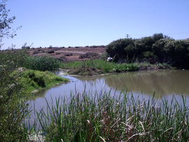
Barker Inlet wetlands at Dry CreekPopulation: 220[1] Postcode: 5094 LGA: City of Salisbury, City of Port Adelaide Enfield State District: Enfield Federal Division: Port Adelaide Suburbs around Dry Creek: Cavan Mawson Lakes Wingfield Dry Creek Gepps Cross Dry Creek is a mostly industrial suburb located north of Adelaide, containing significant wetlands and a substantial area devoted to salt crystallization pans, managed by Cheltenham Salt Limited.
It is named for Dry Creek, a stream and drain which flows out to Gulf St Vincent through the Barker Inlet on the north-east border of the suburb.
It was the site of the soapworks of W. H. Burford & Son from 1923 (adjacent to the Dry Creek railway station)[2] and a pioneering "garden suburb" for its employees, designed by W. J. Earle (who also laid out Cadbury's model town at Claremont, Tasmania).[3] The name Burford Gardens has vanished, but its streets remain: Flame Ave, Gum Ave, Wattle Ave, Grevillea Ave and Bushwood Ave.[4]
Contents
Wetlands
The Dry Creek wetlands are composed of many separate sections running from the eastern edge of the suburb to the sea outlet of Dry Creek. They form part of the storm water management system for the City of Salisbury and the City of Port Adelaide Enfield and are connected to numerous drains that run across the Adelaide Plains including the eponymous Dry Creek, as well as being the outflow point for storm water pipes. Some of the wetlands have been extensively landscaped but have only limited public access.
The wetlands form a fauna and flora haven with one of the southern most mangrove habitats in the world, extensive reed and samphire beds and a large bird and fish population. The discharge via North Arm creek into the Barker Inlet of Gulf St Vincent. The wetlands are part of the Gulf St Vincent Important Bird Area.[5]
Transport
 Dry Creek salt pans
Dry Creek has a train station which is located on the Gawler Central railway line.
References
- ^ Australian Bureau of Statistics (25 October 2007). "Dry Creek (State Suburb)". 2006 Census QuickStats. http://www.censusdata.abs.gov.au/ABSNavigation/prenav/LocationSearch?collection=Census&period=2006&areacode=SSC41366&producttype=QuickStats&breadcrumb=PL&action=401. Retrieved 2008-02-28.
- ^ A Fine New Factory The Advertiser 16 June 1920 p.9 accessed 8 July 2011
- ^ An Old-Established BusinessThe Register 31 May 1922 p.8 accessed 4 July 2011
- ^ Burford Gardens - Wonderful Public Enthusiasm The Mail 14 April 1923 p.1 accessed 8 July 2011
- ^ BirdLife International. (2011). Important Bird Areas factsheet: Gulf St Vincent. Downloaded from http://www.birdlife.org on 03/07/2011
External links
Coordinates: 34°50′S 138°35′E / 34.833°S 138.583°E
Suburbs of the City of Port Adelaide Enfield Alberton · Angle Park · Birkenhead · Blair Athol · Broadview · Clearview · Croydon Park · Dernancourt · Devon Park · Dry Creek · Dudley Park · Enfield · Ethelton · Exeter · Ferryden Park · Gepps Cross · Gilles Plains · Gillman · Glanville · Greenacres · Hampstead Gardens · Hillcrest · Holden Hill · Kilburn · Klemzig · Largs Bay · Largs North · Manningham · Mansfield Park · Northfield · Northgate · North Haven · Oakden · Osborne · Ottoway · Outer Harbor · Peterhead · Port Adelaide · Queenstown · Regency Park · Rosewater · Sefton Park · Semaphore · Semaphore South · Taperoo · Valley View · Walkley Heights · Windsor Gardens · Wingfield · Woodville GardensSuburbs of the City of Salisbury Bolivar · Brahma Lodge · Burton · Cavan · Direk · Dry Creek · Edinburgh · Elizabeth Vale · Globe Derby Park · Green Fields · Gulfview Heights · Ingle Farm · Mawson Lakes · Para Hills · Para Hills West · Para Vista · Parafield · Parafield Gardens · Paralowie · Pooraka · Salisbury · Salisbury Downs · Salisbury East · Salisbury Heights · Salisbury North · Salisbury Park · Salisbury Plain · Salisbury South · St Kilda · Valley View · Walkley Heights · Waterloo CornerCategories:- Suburbs of Adelaide
- Important Bird Areas of Australia
- Adelaide geography stubs


Wikimedia Foundation. 2010.