- Mells, Somerset
-
For other uses, see Mells (disambiguation).
Coordinates: 51°14′20″N 2°23′20″W / 51.2390°N 2.3888°W
Mells 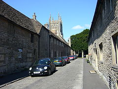
New Street, leading towards St Andrews Church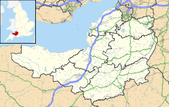
 Mells
Mells
Mells shown within SomersetPopulation 647 [1] OS grid reference ST729489 District Mendip Shire county Somerset Region South West Country England Sovereign state United Kingdom Post town FROME Postcode district BA11 Dialling code 01373 Police Avon and Somerset Fire Devon and Somerset Ambulance South Western EU Parliament South West England UK Parliament Somerton and Frome List of places: UK • England • Somerset Mells is a village and civil parish in Somerset, England, near the town of Frome.
The parish includes the village of Vobster which had a coal mine of the same name on the Somerset coalfield and quarry, both of which are now disused. The old quarry is now used as a diving centre. The Church of St Edmund, at Vobster by Benjamin Ferrey, dates from 1846 and is a Grade II listed building.[2] Vobster Inn Bridge, which carries the lane over the Mells River, is dated 1764, and is Grade II listed.[3]
Contents
History
In the Domesday Book the village was known as "Mulne" meaning several mills.[4] The parish was part of the hundred of Frome.[5]
Around 1500 Mells seems to have been known as Iron Burgh, as a result of the iron ore extracted in the area.[6]
During the 19th and early 20th centuries Mells and surrounding villages had several coal mines on the Somerset coalfield, much of which may have supplied the iron works of James Fussell. The Old Ironstone Works is a biological Site of Special Scientific Interest due to the population of Greater and Lesser Horseshoe bats.
The nearby railway is now the route of NCR 24, the Colliers Way.
Close to the church is the Grade I listed 16th-century manor house,[7] now the residence of Julian Asquith, 2nd Earl of Oxford and Asquith. William Rees-Mogg is another famous resident of the village. The Talbot Inn, a former coaching inn, dates from the 15th century and is Grade II* listed.[8]
Mells Church of England First School, on the edge of the village green, was established in the mid-nineteenth century. It serves Mells and nearby villages and had 78 children on the roll in 2006.[9]
Mells Nursery School provides full day care for children from two years old to school age in a dedicated building which has been constructed adjacent to the school.[10]
Mells holds a daffodil "fayre" on Easter Monday.
Mells Manor was purportedly procured by Jack Horner upon discovering the deed in a pie given to him to carry to London by Richard Whiting, the last Abbot of Glastonbury. This act is referenced in the popular nursery rhyme Little Jack Horner. An alternative explanation is that Mells Park was bought in 1543. After successive generations Thomas Strangeways Horner moved out of the manor house in the village and commissioned Nathaniel Ireson to build Park House within the park.[11]
Governance
The parish council has responsibility for local issues, including setting an annual precept (local rate) to cover the council’s operating costs and producing annual accounts for public scrutiny. The parish council evaluates local planning applications and works with the local police, district council officers, and neighbourhood watch groups on matters of crime, security, and traffic. The parish council's role also includes initiating projects for the maintenance and repair of parish facilities, as well as consulting with the district council on the maintenance, repair, and improvement of highways, drainage, footpaths, public transport, and street cleaning. Conservation matters (including trees and listed buildings) and environmental issues are also the responsibility of the council.
The village falls within the Non-metropolitan district of Mendip, which was formed on 1 April 1974 under the Local Government Act 1972, having previously been part of Frome Rural District,[12] which is responsible for local planning and building control, local roads, council housing, environmental health, markets and fairs, refuse collection and recycling, cemeteries and crematoria, leisure services, parks, and tourism.
Somerset County Council is responsible for running the largest and most expensive local services such as education, social services, libraries, main roads, public transport, policing and fire services, trading standards, waste disposal and strategic planning.
It is also part of the Somerton and Frome county constituency represented in the House of Commons of the Parliament of the United Kingdom. It elects one Member of Parliament (MP) by the first past the post system of election, and part of the South West England constituency of the European Parliament which elects seven MEPs using the d'Hondt method of party-list proportional representation.
Religious sites
The village's most notable feature is St Andrew's Church, a Grade I listed building predominantly from the late 15th century. The tower, which reaches 104 feet (32 m),[13] dates from the mid 16th century.[14] The centre of the chapel is dominated by an equestrian statue to Edward Horner (who fell at the Battle of Cambrai in 1917) by Sir Alfred Munnings. There is also a memorial, designed by Edwin Lutyens, to Raymond Asquith, who died in France in 1916.[13] The churchyard is the last resting place of the poet Siegfried Sassoon and the Catholic priest and writer Ronald Knox, among other notables.
Gallery of images
-

Selwood Street
-

War Memorial by Sir Edwin Lutyens
-

Traditional thatched cottages
-

Mells Church of England First School (photo by Patrick Mackie)
-

St Edmund's Church at Vobster
Famous people
Jenson Button, the Formula One racing driver, hails from Vobster.
References
- ^ "Parish Population Statistics". ONS Census 2001. Somerset County Council. http://www.webcitation.org/5lRyC5ccr. Retrieved 14 December 2009.
- ^ "Church of St Edmund". Images of England. http://www.imagesofengland.org.uk/details/default.aspx?id=266781. Retrieved 14 November 2006.
- ^ "Vobster Inn Bridge". Images of England. http://www.imagesofengland.org.uk/details/default.aspx?id=266782. Retrieved 14 November 2006.
- ^ Robinson, W.J. (1915). West Country Churches. Bristol: Bristol Times and Mirror Ltd. p. 37.
- ^ "Somerset Hundreds". GENUKI. http://www.genuki.org.uk/big/eng/SOM/Miscellaneous/. Retrieved 8 October 2011.
- ^ Toulson, Shirley (1984). The Mendip Hills: A Threatened Landscape. London: Victor Gollancz. ISBN 057503453X.
- ^ "Mells Manor". Images of England. http://www.imagesofengland.org.uk/details/default.aspx?id=266729. Retrieved 13 May 2006.
- ^ "The Talbot Inn". Images of England. http://www.imagesofengland.org.uk/details/default.aspx?id=266734. Retrieved 13 May 2006.
- ^ "Mells Church of England First School". 2006. http://www.mellsfirst.ik.org/. Retrieved 3 September 2006.
- ^ "Mells Nursery". 2006. http://www.mellsnursery.ik.org/. Retrieved 9 September 2006.
- ^ Firth, Hannah (2007). Mendip from the air. Taunton: Somerset County Council. ISBN 9780861833900.
- ^ A Vision of Britain Through Time : Frome Rural District
- ^ a b Leete-Hodge, Lornie (1985). Curiosities of Somerset. Bodmin: Bossiney Books. p. 20. ISBN 0906456983.
- ^ "Church of St Andrew". Images of England. http://www.imagesofengland.org.uk/details/default.aspx?id=266724. Retrieved 13 May 2006.
External links
Towns, villages and hamlets in the Mendip district of Somerset, England 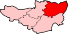 Ashwick · Baltonsborough · Batcombe · Beckington · Berkley · Binegar · Buckland Dinham · Chewton Mendip · Chilcompton · Coleford · Cranmore · Croscombe · Ditcheat · Doulting · Downhead · East Lydford · East Pennard · Emborough · Evercreech · Frome · Glastonbury · Godney · Great Elm · Hemington · Holcombe · Kilmersdon · Lamyat · Leigh-on-Mendip · Litton · Lullington · Lydford-on-Fosse · Meare · Mells · Milton Clevedon · North Wootton · Norton St Philip · Nunney · Pilton · Priddy · Pylle · Rode · Rodney Stoke · Rudge · Selwood · Sharpham · Shepton Mallet · St Cuthbert Out · Stoke St Michael · Ston Easton · Stratton-on-the-Fosse · Street · Tellisford · Trudoxhill · Upton Noble · Walton · Wanstrow · Wells · West Bradley · West Lydford · West Pennard · Westbury-sub-Mendip · Whatley · Witham Friary · Wookey · Wookey HoleCategories:
- Villages in Mendip
- Somerset coalfield
- Civil parishes in Somerset
-


Wikimedia Foundation. 2010.