- Maryland Route 304
-
Maryland Route 304

Route information Maintained by MDSHA Length: 15.23 mi[1][2] (24.51 km) Major junctions West end: Spider Web Road west of Centreville  MD 213 in Centreville
 US 301 near Centreville
 MD 481 in Ruthsburg
 MD 405 near Bridgetown
East end:  MD 312 in Bridgetown
Location Counties: Queen Anne's, Caroline Highway system Maryland highway system
Interstate • US • State • Minor • Former • Turnpikes←  MD 303
MD 305  →
→Maryland Route 304 (MD 304) is a state highway in the U.S. state of Maryland. The state highway runs 15.23 miles (24.51 km) from Spider Web Road west of Centreville east to MD 312 in Bridgetown. MD 304 connects Centreville with U.S. Route 301 (US 301) and several small settlements in central Queen Anne's County and northern Caroline, including Ruthsburg and Bridgetown. MD 304 originally consisted of its present streets in Centreville and a short piece of road to the east. The state highway was gradually extended eastward across central Queen Anne's County in the late 1930s and 1940s, reaching Ruthsburg in 1948. West of Centreville, MD 304 took over MD 606 in 1951 to achieve its present western terminus. The state highway was extended east to Bridgetown in the mid 1960s, taking over part of MD 405. Maintenance of the streets in Centreville was returned to the town in the 1960s.
Contents
Route description
MD 304 begins at the intersection of Corsica Neck Road and Spider Web Road on the Corsica Neck peninsula west of Centreville. The state highway heads east as two-lane Corsica Neck Road through a mix of farmland and forest. MD 304 crosses Earl Creek then crosses the Corsica River to enter the town of Centreville, where the highway is municipally-maintained and passes through the Centreville Historic District. The highway's name changes to Chesterfield Avenue and it passes through a residential area with scattered county offices. In the downtown area one block south of the Queen Anne's County Courthouse, MD 304 meets MD 213, which follows a one-way pair through the town, Liberty Street southbound and Commerce Street northbound. MD 304 continues east as Water Street, crossing the Centreville Branch of the Northern Line of the Maryland and Delaware Railroad. At Tilghman Street, the highway's name changes to Railroad Avenue. MD 304 leaves Centreville just east of Kidwell Avenue.[1][3]
MD 304 continues east through farmland as Ruthsburg Road, passing Queen Anne's County High School and Centreville Middle School before reaching the intersection with US 301 (Blue Star Memorial Highway). The state highway intersects MD 481 (Damsontown Road) in the hamlet of Ruthsburg. MD 304 heads northeast and crosses German Branch before intersecting MD 405 (Price Station Road).[1][3] Shortly after the highway enters Caroline County by crossing Mason Branch, the highway, now named Bridgetown Road, reaches its eastern terminus at MD 312 (Oakland Road) in the village of Bridgetown. Bridgetown Road continues east as a county highway toward Goldsboro.[2][3]
History
The first section of present day MD 304 to be paved was the Bridgetown Road segment, which was built as a state aid road by 1915.[4] Water Street, Railroad Avenue, and Ruthsburg Road east to Rolling Bridge Road were paved as a state aid road by 1921.[5] Chesterfield Avenue was paved as a state road in 1924 and 1925.[6][7] Corsica Neck Road and a new bridge across the Corsica River were completed in 1935, and designated MD 606.[8][9][10] MD 304 was extended to a point just east of present day US 301 in 1938.[11][12] The state highway was extended to Greenville Road in 1942 and to MD 481 in Ruthsburg in 1948.[13][14][15][16]
Current MD 304 near Bridgetown was constructed as part of MD 405 and completed in 1942 to Bridgetown.[13][14] In 1951, MD 304 was extended west over MD 606 to its present western terminus.[17] MD 304 was extended east of MD 481 and assumed MD 405's route into Bridgetown to its present eastern terminus in 1964.[18] Chesterfield Avenue was returned to the town of Centreville to maintain by 1961; Water Street and Railroad Avenue were transferred in 1968.[19][20]
Junction list
County Location Mile
[1][2]Intersection Notes Queen Anne's 0.00 Corsica Neck Road west / Spider Web Road south Western terminus Centreville 3.21 MD 213 south (Liberty Street) – Wye Mills3.28 MD 213 north (Commerce Street) – Church Hill5.79 US 301 (Blue Star Memorial Highway) – Bay Bridge, WilmingtonRuthsburg 9.99 MD 481 south (Damsontown Road) – Tuckahoe State Park, Queen Anne13.85 MD 405 north (Price Station Road) – Church HillCaroline Bridgetown 15.23 MD 312 (Oakland Road) – Ridgely, Baltimore CornerEastern terminus Bridgetown Road east – Goldsboro 1.000 mi = 1.609 km; 1.000 km = 0.621 mi References
- ^ a b c d "Highway Location Reference: Queen Anne's County" (PDF). Maryland State Highway Administration. 2009. http://www.marylandroads.com/Location/2009_QUEENANNES.pdf. Retrieved 2010-09-28.
- ^ a b c "Highway Location Reference: Caroline County" (PDF). Maryland State Highway Administration. 2009. http://www.marylandroads.com/Location/2009_CAROLINE.pdf. Retrieved 2010-09-28.
- ^ a b c Google, Inc. Google Maps – Maryland Route 304 (Map). Cartography by Google, Inc. http://maps.google.com/maps?f=d&source=s_d&saddr=MD-304+E%2FCorsica+Neck+Rd&daddr=MD-304+E%2FBridgetown+Rd&geocode=Ff4FVAId6oV2-w%3BFVafUwIdbj96-w&hl=en&mra=ls&sll=39.053718,-76.118174&sspn=0.015297,0.038581&ie=UTF8&t=h&z=12. Retrieved 2010-09-28.
- ^ Report of the State Roads Commission of Maryland. 1912-1915. Baltimore: Maryland State Roads Commission. May 1915. pp. 122, 128. http://www.archive.org/details/annualreportsofs1912mary. Retrieved 2010-09-28.
- ^ Maryland Geological Survey. Map of Maryland: Showing State Road System and State Aid Roads (Map) (1921 ed.).
- ^ Report of the State Roads Commission of Maryland. 1924-1926. Baltimore: Maryland State Roads Commission. January 1927. pp. 33, 95. http://www.archive.org/details/annualreportsofs1924mary. Retrieved 2010-09-28.
- ^ Maryland Geological Survey. Map of Maryland: Showing State Road System and State Aid Roads (Map) (1927 ed.).
- ^ Report of the State Roads Commission of Maryland. 1931-1934. Baltimore: Maryland State Roads Commission. 1934-12-28. p. 351. http://www.archive.org/details/reportofstateroa1931mary. Retrieved 2010-09-28.
- ^ Maryland Geological Survey. Map of Maryland Showing State Road System: State Aid Roads and Improved County Road Connections (Map) (1935 ed.).
- ^ Maryland State Roads Commission. General Highway Map: State of Maryland (Map) (1939 ed.).
- ^ Report of the State Roads Commission of Maryland. 1937-1938. Baltimore: Maryland State Roads Commission. 1939-03-04. p. 105. http://www.archive.org/details/reportofstateroa1937mary. Retrieved 2010-09-28.
- ^ Maryland State Roads Commission. Map of Maryland Showing State Road System (Map) (1938 ed.).
- ^ a b Report of the State Roads Commission of Maryland. 1941-1942. Baltimore: Maryland State Roads Commission. 1943-03-15. p. 81. http://www.archive.org/details/reportofstateroa1941mary. Retrieved 2010-09-28.
- ^ a b Maryland State Roads Commission. Maryland: Official Highway Map (Map) (1946-47 ed.).
- ^ Report of the State Roads Commission of Maryland. 1947-1948. Baltimore: Maryland State Roads Commission. 1949-02-15. p. 106. http://www.archive.org/details/reportofstateroa1947mary. Retrieved 2010-09-28.
- ^ Maryland State Roads Commission. Maryland: Official Highway Map (Map) (1950 ed.).
- ^ Maryland State Roads Commission. Maryland: Official Highway Map (Map) (1951 ed.).
- ^ Maryland State Roads Commission. Maryland: Official Highway Map (Map) (1964 ed.).
- ^ Maryland State Roads Commission. Maryland: Official Highway Map (Map) (1961 ed.).
- ^ Maryland State Roads Commission. Maryland: Official Highway Map (Map) (1968 ed.).
External links
Roads in Caroline County, Maryland State highways 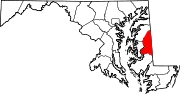
Roads in Queen Anne's County, Maryland State highways 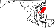
U.S. Highways Categories:- State highways in Maryland
- Roads in Queen Anne's County, Maryland
- Roads in Caroline County, Maryland


Wikimedia Foundation. 2010.