- Stanford Battle Area
-
Stanford Training Area 
Type Training Area Coordinates 52°31′15″N 0°45′17″E / 52.52078°N 0.75480°E Current
ownerMinistry of Defence Controlled by British Army Stanford Battle Area, better known as the Stanford Training Area (STANTA), is a British Army training area situated in the English county of Norfolk. The area is approximately 30,000 acres (120 km2) in size; it is some 7 miles (11 km) north of the town of Thetford and 25 miles (40 km) south-west of the city of Norwich.[1] The site is run by the Operational Training and Advisory Group (OPTAG).[1]
The area was originally established in 1942 when a battle training area was required and a 'Nazi village' established.[2] Military exercises were already known in the area; tanks had deployed to Thetford in the First World War. The complete takeover involved the evacuation of the villages of Buckenham Tofts, Langford, Stanford, Sturston, Tottington and West Tofts.[2]
The area was used during the run-up to the D-Day invasion and since then has hosted many exercises. A regular visitor is 16 Air Assault Brigade who hold their annual Gryphon exercises there.
In 2009 a 12.5-acre (51,000 m2) village designed to replicate its Afghan equivalent, was added to the Battle Area for the training of troops deployed in support of the War in Afghanistan. The site, built at a cost of £14 million, is state of the art and manned by Afghan nationals[3], ex-Gurkha soldiers and amputees from 'Trauma FX', who simulate tha Afghan National Army, locals and wounded soldiers.[4] The village includes houses, a market and a mosque, It also features a system that pumps out smells like rotten meat and sewage.[3]
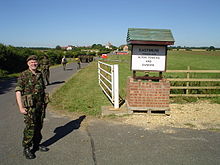 Entrance to Eastmere
The battle area includes four historic churches, the one at West Tofts having been restored by Pugin and a new "church" that forms part of the specially constructed village of Eastmere. Eastmere was originally built to give soldiers experience of fighting on the northern European plains.
There is a short landing strip for Harrier aircraft at 52°32′29″N 0°42′06″E / 52.541422°N 0.701805°E
As a live firing area, access is not allowed without special permission from the Army. In the main this is limited to a number of tours a year and compassionate grounds for former residents of the villages or their relatives.
The area forms part of the distinctive Breckland landscape region, a gorse-covered sandy heath which offers poor agricultural opportunities. Arguably, its use as a military training area has safeguarded a substantial archaeological landscape. It is the home of a wealth of rare species of flora and fauna already lost in other parts of the country. Parts of the training area are designated Site of Special Scientific Interest (SSSI). The battle area has had much less impact than the establishment of Thetford Forest on adjoining land.[citation needed]
The battle area was used in the filming of many of the episodes of the comedy series Dad's Army.
References
- ^ Ordnance Survey (1999). OS Explorer Map 229 - Thetford in the Brecks. ISBN 0-319-21861-9.
- ^ NorfolkChurches.co.uk. Norfolk battle training area churches. Retrieved February 17, 2006.
- ^ Telegraph. An Afghan village has been built by the Ministry of Defence in Thetford, Norfolk. Retrieved May 12 2009.
External links
See also BBC WW2 Peoples War site Breckland Exodus-The Forced Evacuation of the Norfolk Battle Area 1942 Part 1
See also BBC WW2 Peoples War site Breckland Exodus-The Forced Evacuation of the Norfolk Battle Area 1942 Part 2 by Conal O'Donnell
Violets for Vera-the death of West Tofts School 1942 by Conal O'Donnell
Touring the Stanta ghost villagesCategories:- Training establishments of the British Army
- Geography of Norfolk
- Military in Norfolk
- Sites of Special Scientific Interest in Norfolk


Wikimedia Foundation. 2010.