- New York State Route 12
-
"NY 12" redirects here. NY 12 may also refer to New York's 12th congressional district.
NYS Route 12

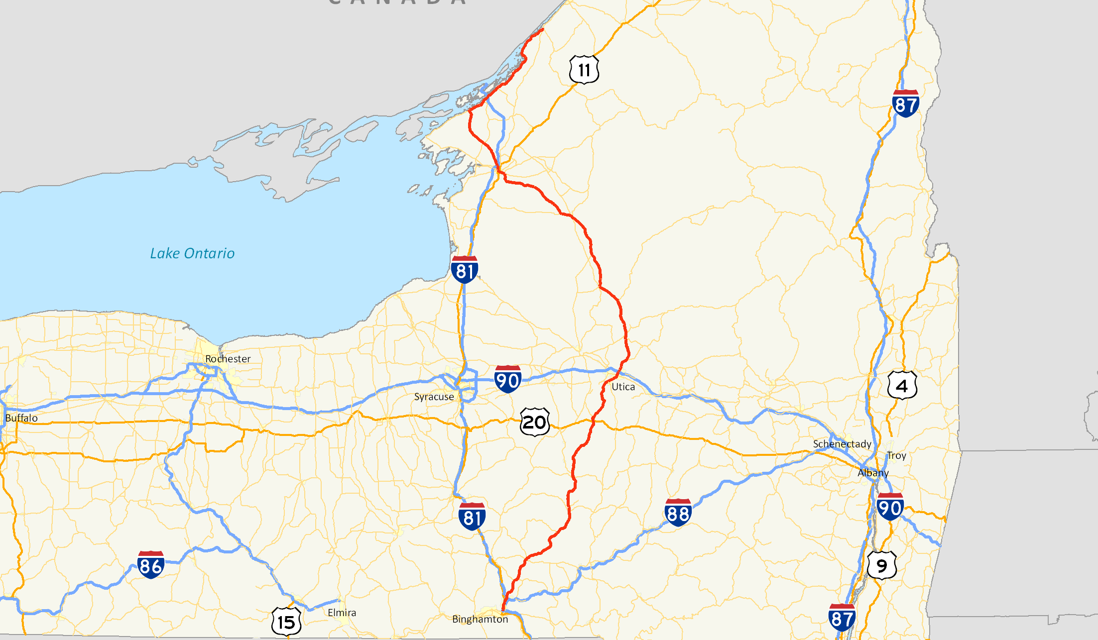
Map of Upstate New York with NY 12 highlighted in redRoute information Maintained by NYSDOT and the city of Watertown Length: 222.27 mi[2] (357.71 km) Existed: 1924[1] – present Major junctions South end:  US 11 in Chenango
 NY 23 in Norwich
 US 20 in Sangerfield


 I-790 / NY 5 / NY 8 in Utica
 US 11 / NY 3 in Watertown
 I-81 in Orleans
North end:  NY 37 in Morristown
Location Counties: Broome, Chenango, Madison, Oneida, Lewis, Jefferson, St. Lawrence Highway system Numbered highways in New York
Interstate • U.S. • N.Y. (former) • Reference • County←  NY 11C
NY 12B  →
→New York State Route 12 (NY 12) is a state highway extending for 222.27 miles (357.71 km) through central and northern New York in the United States. The southern terminus of the route is at U.S. Route 11 (US 11) in the town of Chenango (just north of Binghamton) in the Southern Tier. The northern terminus is at NY 37 near the village of Morristown in the North Country. In between, the route serves three cities of varying size: Norwich, Utica, and Watertown. The distance between Utica and Binghamton is a major trucking route, and features many gas stations, truck stops, and fast food restaurants. Between Watertown and Morristown, it follows the St. Lawrence River valley.
It is a two lane, undivided, full access roadway for the majority of its length, except between the village of New Hartford and Alder Creek, where it is a 4-lane highway. Within that span, it is a limited access highway in the city of Utica, referred locally as The Arterial and the North–South Arterial.
Route 12 intersects several primary east–west routes, including US 20, NY 5, and NY 3. From Barneveld to the town of Remsen (a distance of 11 miles or 18 kilometres), NY 12 overlaps NY 28. NY 12 also intersects US 11 twice: once at its beginning in Binghamton and once in Watertown. Between these intersections, NY 12 arcs eastward from US 11, with the stretch right after Utica being its eastern apex. NY 12 also connects with Interstate 81 (I-81) near both its beginning and end points in the same manner.
NY 12, as originally assigned in 1924, extended from Chenango in the south to Clayton in the north. It was extended east over the former routing of NY 3 to Alexandria Bay in 1930, then along a new roadway to Morristown in the 1960s. Parts of NY 12 have been rerouted onto new roadways in areas, primarily in Oneida County.
Contents
Route description
Broome and Chenango Counties
NY 12 begins at US 11 north of Binghamton in the central Broome County town of Chenango. The route heads north through the Chenango River valley, connecting to both I-81 (via US 11) and I-88 (via NY 12A) and passing west of Chenango Valley State Park before traversing the Tioughnioga River (just west of where it forks from the Chenango) near the community of Chenango Forks. On the northern bank of the river, NY 12 intersects and briefly overlaps NY 79 before continuing northward through the valley and into Chenango County.
 NY 12 begins its 200+ mile journey here at US 11 just north of Binghamton in Chenango.
Within Chenango County, NY 12 acts as the primary connector between the numerous communities located along the Chenango. In Greene, NY 12 intersects NY 206 and overlaps NY 41 for six blocks through the village before continuing northeast for 12 miles (19 km) to Oxford, home to a short concurrency with NY 220. After another 6 miles (10 km), NY 12 enters the city of Norwich, the largest settlement on the route in the county, and becomes South Broad Street. The South Broad moniker remains with the route northward through the city until the downtown district, where NY 12 turns into North Broad Street at a junction with NY 23. NY 12 loses the street name soon afterward as it leaves the city and intersects NY 320 north of Norwich and south of Norwich Lt. Warren Eaton Airport.
The route and the Chenango River remain in close proximity to one another up through the village of Sherburne, situated at the junction between NY 12 and NY 80. North of the village center, the river breaks to the west, following NY 12B to the northwest while NY 12 continues northward into rural Madison County.
Madison and Oneida Counties
 NY 12 north at NY 315 in Waterville
Across the county line, NY 12 joins the Sangerfield River as it heads north through the narrow southeastern portion of the county (with a width of only 10 miles or 16 kilometres). Near the northern border of Madison County, the route shifts slightly east to bypass a marshy area around the Sangerfield River known as the Ninemile Swamp. The conditions persist into Oneida County to just south of the Sangerfield hamlet of the same name, where the swamp ends as the river curves away from NY 12. At the actual community, NY 12 intersects US 20.
The route continues north for an additional 1 mile (1.6 km) to the village of Waterville, home to an intersection between NY 12 and NY 315. Outside of Waterville, NY 12 heads north once more through hilly, sparsely populated areas of New York toward Utica. In the Utica suburb of New Hartford, the route intersects NY 5 a short distance east of where NY 12B terminates at NY 5. NY 12 turns east, joining NY 5 northeast on a limited-access highway known locally as the North–South Arterial. Upon crossing into the Utica city limits, the Arterial intersects NY 8 and NY 840 by way of a cloverleaf interchange. NY 8 joins the freeway here, following NY 5 and NY 12 through southern Utica as the arterial meets French Road and Burrstone Road by way of a pair of interchanges. After the Burrstone Road interchange, the arterial becomes a divided highway through downtown before becoming limited-access once more at an interchange with Oriskany Street (NY 5A and NY 5S).
 Diagram of the interchange between I-790, NY 5, NY 8, NY 12 and NY 49
Between Oriskany Street and the New York State Thruway (I-90), NY 5, 8, and 12 is part of the Interstate Highway System as I-790 overlaps all three routes northward over the Mohawk River and the Erie Canal before leaving the arterial at a large interchange on the north bank of the canal. NY 5 turns off as well, following I-790 eastward. Meanwhile, NY 8 and NY 12 interchange with NY 49 (the Utica–Rome Expressway), partially via the I-790 exit ramps, and passes over the Thruway before continuing northward out of the city limits.
NY 8 and NY 12 remain limited-access as they proceed through the northern suburbs of Utica, connecting to Mulaney Road and Trenton Road via interchanges in Deerfield. Farther north in the town, NY 8 leaves the freeway by way of a trumpet interchange. Although the amount of development around NY 12 declines as it heads northward, it continues as an expressway to a point north of the Putnam Road interchange in Trenton, where the road reverts to a limited-access four-lane highway. This configuration remains through the villages of Barneveld (where NY 28 joins NY 12 south of the village and NY 12 connects to NY 365 via an interchange) and Remsen to the vicinity of Alder Creek in the town of Boonville, where NY 28 leaves NY 12 via a partial trumpet interchange and the road narrows to two lanes shortly afterward.
 Junction of NY 12 and NY 12D near Boonville
From Alder Creek to Boonville, NY 12 loosely follows the path of the Black River as it heads northwest. Inside Boonville, NY 12D departs NY 12 and begins to follow a northward routing parallel to that of its parent. Together with NY 12D and the Black River, NY 12 passes into the region of New York known as the North Country.
North Country
The path of NY 12 through New York's North Country consists of three primary subregions: rural Lewis County, urban Watertown, and the numerous communities that line the southern bank of the St. Lawrence River, here the geographical divide between the United States and Canada.
Lewis County
NY 12, NY 12D, and the Black River continue to follow parallel routings north through the village of Port Leyden to Lyons Falls, where NY 12D returns to NY 12 by way of an intersection just west of the village. NY 12 then passes under NY 12D, which heads north from NY 12 on Cherry Street to access Lyons Falls before heading west over NY 12 and out of the village. NY 12, however, continues on in the vicinity of the Black River to Lowville, where NY 12 briefly overlaps NY 26 and meets NY 812 before leaving both the village and the river to the west.
 Approaching NY 126 on NY 12 northbound
3 miles (5 km) outside of Lowville at West Lowville, NY 12 leaves its due west alignment and curves to the northwest, with the westerly alignment continuing onward as NY 177. From West Lowville to the area surrounding Copenhagen, NY 12 passes through largely undeveloped terrain, save for a pair of isolated roadside communities. This trend ceases, albeit temporary, in the village of Copenhagen, located on the banks of the Deer River at the crossroads of NY 12 and the former NY 194 (now County Route 194 or CR 194). Outside the limits, the route resumes its trek through the rural North Country.
Watertown area
Route 12 enters Jefferson County on its way to Watertown just north of Copenhagen.[3] Route 12 is known as Van Allen Road, crossing with Jefferson county roads in Rutland. At the intersection with County Road 67, Route 12 turns to the north and enters Watertown as Gifford Street. Route 12 intersects with NY 126 just northeast of Thompson Park and Watertown Golf Club and turns to the northwest. As Route 12 continues through southern parts of Watertown, NY 3 intersects and becomes concurrent. Routes 3 and 12 enter Watertown Public Square and split into divided highways. Here, NY 283 starts to the northeast.[3]
Routes 3 and 12 split, just northwest of the Public Square.[3] Route 3 splits to the west, Route 12 heads to the northwest, and quickly becomes concurrent with US 11. The two roads cross a river and split in different directions. Route 12 heads to the northeast, intersecting with a suffixed route, 12E, and passes North Watertown Cemetery before connecting to I-81 at exit 47. Route 12 leaves Watertown afterwards[3] and heads northeast through rural northwestern Jefferson County. North of Perch Lake in the southeastern corner of the town of Clayton, NY 12 intersects NY 180.
10 miles (16 km) north of NY 180, NY 12 reaches the village of Clayton on the St. Lawrence River. Inside the village, NY 12E completes its lengthy alternate loop of NY 12, terminating at its parent in the village center. NY 12 turns east here, following State Street out of Clayton.
St. Lawrence River
NY 12 continues northeast along the south bank of the St. Lawrence, intersecting Mason Point Road (a local road leading to a Thousand Islands-bound ferry) and NY 180, and passing south of Grass Point State Park prior to encountering I-81 at exit 50 4 miles (6 km) southwest of the village of Alexandria Bay. Farther northeast, NY 12 passes by Keewaydin State Park before intersecting the northern terminus of NY 26 in the southwestern portion of the village.
Outside of Alexandria Bay, NY 12 temporarily turns east and leaves the riverbank to avoid Goose Bay, a small body of water partially separated from the St. Lawrence by two protruding points of land. The route then curves back toward the water and follows the eastern length of the bay, serving the seaside hamlet of Goose Bay near the bay's midpoint. North of Goose Bay, NY 12 intersects Kring Point Road, an access road leading to Kring Point State Park, and crosses into St. Lawrence County.
NY 12 continues along the southern bank of the St. Lawrence River as it proceeds through the rural western portion of the county. 5 miles (8 km) from the county line and 11 miles (18 km) from Alexandria Bay in the town of Hammond, NY 12 intersects CR 6, a roadway leading east to the village of Hammond and Black Lake. Farther north in Morristown, NY 12 travels through Jacques Cartier State Park before terminating at an interchange with NY 37 just south of the Morristown village limits.
History
Origins and designation
In 1908, the New York State Legislature created Route 8, an unsigned legislative route extending from Binghamton to Kirkland (west of Utica) via Greene, Norwich, Sherburne, Bouckville, and Oriskany Falls. Also assigned at this time was Route 25, which passed through Barneveld, Remsen and Forestport on its way from Whitesboro to Albany, and Route 27, which began at Route 25 in Forestport and went northwest to Alexandria Bay by way of Boonville, Potters Corners, Lowville, Carthage, Watertown, and Clayton. Route 25 originally went directly from Barneveld to Remsen;[4][5] however, it was realigned by 1920 to serve the village of Prospect to the east.[5]
When the first set of posted routes in New York were assigned in 1924, NY 12 was assigned to an alignment extending from Binghamton to Clayton via Norwich, Utica, and Watertown.[1] It utilized legislative Route 8 from Binghamton to just south of Clinton, where it veered northeast to serve the city of Utica instead of continuing north on Route 6 (modern NY 233) to Kirkland. In the vicinity of Utica, NY 12 initially followed Clinton Road, Genesee Street, and Trenton Road through the city. Past Utica, it continued north on Trenton Road to a point south of Trenton (now Barneveld), where it briefly followed its current routing. NY 12 turned off again in Trenton to follow legislative Route 25's original alignment on Mappa Avenue in Trenton and Main Street in Remsen. NY 12 continued north from Remsen on legislative Route 25.[6]
At Forestport, NY 12 left Route 25 to follow legislative Route 27 to Lowville. In Lowville, NY 12 split from Route 27 and proceeded northwest to Watertown via Copenhagen, bypassing the slightly more circuitous route that Route 27 took via Carthage on modern NY 26, NY 126, and NY 3. NY 12 rejoined legislative Route 27 in Watertown and followed it to Clayton, where NY 12 ended at NY 3,[6] which was also assigned in 1924.[1] At the time, the segment of legislative Route 27 between Clayton and Alexandria Bay was designated as part of NY 3.[1][6]
Realignments and terminus changes
 The junction of NY 12 and NY 12B in Sherburne. At different points in the 1920s, the straight path carried NY 12 and NY 12A.
In the late 1920s, NY 12 was realigned between Sherburne and Utica to follow a more direct alignment between the two locations via Sangerfield. Its former routing to the west became NY 12A (now NY 12B). As a result, NY 12 now entered Utica on Paris Road.[6][7] In the 1930 renumbering of state highways in New York, NY 3 was rerouted onto its current alignment east of Watertown while the former routing of NY 3 from Clayton to Alexandria Bay became an extension of NY 12.[8] Also created as part of the renumbering was NY 12D, an alternate route of NY 12 between Potters Corners and Lowville via Lyons Falls.[9] By the following year, NY 12D was rerouted south of Lyons Falls to follow a routing similar to modern NY 12 to Boonville.[10] The alignments of NY 12 and NY 12D between the two villages were swapped ca. 1939, placing NY 12D on the direct highway between the two and NY 12 on the slightly more circuitous route via Lyons Falls.[11][12]
NY 12 originally extended southward into downtown Binghamton by way of an overlap with US 11.[13] The overlap was eliminated at some point between 1947 and 1970.[14][15] On its north end, NY 12 was extended northeast over a new roadway along the St. Lawrence River to NY 37 in Morristown in the mid-1960s.[16][17]
Bypasses
NY 12 has been realigned onto divided highways and limited-access highways over the years, particularly in Oneida County, to bypass communities along its routing. The first bypass that was constructed in Oneida County was around Remsen in the early 1950s. NY 12 was realigned onto the bypass, which passed to the west of the village, by 1954.[18][19] Construction began by 1956 on a southward extension of the bypass that would take NY 12 around the eastern edge of Barneveld.[20] It opened to traffic by 1958.[21] Farther south, in Utica, a new limited-access highway was built through the downtown portion of the city in the early 1960s. At the time, it began at French Road and ended at Trenton Road. It became a realignment of NY 12 by 1964.[22][23] An extension of the road southwest to Genesee Street in New Hartford was completed by 1968, at which time NY 12 was realigned to follow New Paris Road into the city.[17] A limited-access highway bypassing Trenton Road and linking the Utica expressway and the Barneveld–Remsen bypass was completed by 1973, resulting in the rerouting of NY 12 onto the roadway.[24] The former routing of NY 12 along Trenton Road from the Utica city line to Powell Road is now CR 91.[25]
The route has also been realigned in areas to bypass smaller communities along the highway. One such location is in the vicinity of the village of Greene, where NY 12 initially followed Chenango Street through the village.[26] The current bypass around the western edge of the village was built in the late 1970s and completed by 1981.[27][28]
Suffixed routes
 Western terminus of NY 12A at NY 12. The route provides access to I-88 from NY 12.
NY 12 has had seven suffixed routes bearing six different designations. Two have since been removed and at least partially renumbered. All of the routes were assigned as part of the 1930 renumbering of state highways in New York unless otherwise noted.[8][9][29]
- The NY 12A designation has been used for two distinct highways:
- The first NY 12A was an alternate route of NY 12 between Sherburne and Utica. It was assigned in the late 1920s and renumbered to NY 12B in the 1930 renumbering of state highways in New York.[6][8]
- The current NY 12A (0.98 miles or 1.58 kilometres) is an east–west spur connecting NY 12 to I-88 and NY 7 on the banks of the Chenango River in Chenango Bridge, Broome County. The entire route is known as Chenango Bridge Road and is one of only six signed New York state highways less than a mile in length.[2] The route was assigned in the early 1930s.[26][29]
- NY 12B (33.57 miles or 54.03 kilometres) is an alternate route of NY 12 between Sherburne and Utica.[2]
- NY 12C is a former alternate route of NY 12 between Utica and Barneveld.[17] The route was eliminated in 1970, at which time the lone portion of NY 12C that did not overlap another state route was redesignated as NY 291.[15]
- NY 12D (11.50 miles or 18.51 kilometres) is an alternate route of NY 12 between Boonville and Lyons Falls.[2]
- NY 12E (39.76 miles or 63.99 kilometres) is an alternate route of NY 12 between Watertown and Clayton. While NY 12 follows a direct path between the two locations, NY 12E veers to the west to serve communities along Lake Ontario and the St. Lawrence River.[2]
- NY 12F (6.89 miles or 11.09 kilometres) is a spur connecting NY 12 in downtown Watertown to NY 180 near the Watertown International Airport in Dexter.[2]
Major intersections
County Location Mile[2] Destinations Notes Broome Chenango 0.00 US 110.53  NY 12A
Western terminus of NY 12A Barker 6.40  NY 79 north
Southern terminus of NY 12 / NY 79 overlap 6.63 NY 79 southNorthern terminus of NY 12 / NY 79 overlap Chenango Village of Greene 14.30 
 NY 41 south / NY 206
Southern terminus of NY 12 / NY 41 overlap 14.76 NY 41 northNorthern terminus of NY 12 / NY 41 overlap Village of Oxford 27.82  NY 220 west
Southern terminus of NY 12 / NY 220 overlap 28.46 NY 220 eastNorthern terminus of NY 12 / NY 220 overlap City of Norwich 35.73  NY 990L
Southern terminus of NY 990L; former eastern terminus of NY 319 36.12 NY 23Town of Norwich 37.22  NY 320
Western terminus of NY 320 Village of Sherburne 47.38  NY 80
NY 8048.13 NY 12BSouthern terminus of NY 12B Oneida Sangerfield 66.33 US 20Waterville 67.62  NY 315
Southern terminus of NY 315 Town of New Hartford 79.89 NY 5 westSouthern terminus of NY 5 / NY 12 overlap Utica 80.54  NY 8 south / NY 840
Cloverleaf interchange; southern terminus of NY 8 / NY 12 overlap; eastern terminus of NY 840 83.83 
 I-790 / NY 5A / NY 5S (Oriskany Street)
Eastern terminus of NY 5A; western terminus of NY 5S; southern terminus of I-790; southern terminus of I-790 / NY 12 overlap 84.70  I-790 north / NY 5 east / NY 49
Eastern terminus of NY 49; northern terminus of I-790 / NY 12 and NY 5 / NY 12 overlaps; to I-90 / Thruway Deerfield 89.82 NY 8 northNorthern terminus of NY 8 / NY 12 overlap 95.96  NY 28 south
Southern terminus of NY 12 / NY 28 overlap Trenton 97.67  NY 365
Town of Remsen 107.39 NY 28 northNorthern terminus of NY 12 / NY 28 overlap Village of Boonville  NY 12D
Southern terminus of NY 12D Lewis Lyons Falls 124.35 NY 12DNorthern terminus of NY 12D Village of Lowville 137.94  NY 26 south
Southern terminus of NY 12 / NY 26 overlap 138.52  NY 26 north / NY 812
Northern terminus of NY 12 / NY 26 overlap; southern terminus of NY 812 Town of Lowville 141.34  NY 177
Eastern terminus of NY 177 Copenhagen 150.94  CR 194
Former eastern terminus of NY 194 Jefferson Town of Watertown 163.57  NY 126
Western terminus of NY 126 City of Watertown 163.95 NY 3 eastEastern terminus of NY 3 / NY 12 overlap 165.37 US 11 north / NY 3 westWestern terminus of NY 3 / NY 12 overlap (northbound); eastern terminus of US 11 / NY 12 overlap (southbound); southern terminus of US 11 / NY 12 overlap (northbound)  NY 283 (Factory Street)
Northbound intersection; western terminus of NY 283 US 11 north (Washington Street)Southbound intersection; western terminus of US 11 / NY 12 overlap 165.72 US 11 north (Mill Street)Northbound intersection; northern terminus of US 11 / NY 12 overlap US 11 south (South Massey Street) / NY 3 west (Arsenal Street)Southbound intersection; western terminus of NY 3 / NY 12 overlap; southern terminus of US 11 / NY 12 overlap  NY 12F (Coffeen Street)
Southbound intersection; eastern terminus of NY 12F 166.12 US 11 south (Leray Street)Northern terminus of US 11 / NY 12 overlap (southbound) 166.35  NY 12E
Southern terminus of NY 12E Pamelia 167.52 I-81Exit 47 (I-81) 169.64  NY 342
Town of Clayton 175.49  NY 180
187.10 NY 12ENorthern terminus of NY 12E Orleans 192.21 NY 180Northern terminus of NY 180 194.22 I-81Exit 50 (I-81) Alexandria Bay 198.20 NY 26Northern terminus of NY 26 St. Lawrence Town of Morristown 222.27 NY 371.000 mi = 1.609 km; 1.000 km = 0.621 mi References
- ^ a b c d "New York's Main Highways Designated by Numbers". The New York Times: p. XX9. December 21, 1924.
- ^ a b c d e f g "2008 Traffic Data Report for New York State" (PDF). New York State Department of Transportation. June 16, 2009. pp. 118–122. https://www.nysdot.gov/divisions/engineering/technical-services/hds-respository/NYSDOT_Traffic_Data_Report_2008.pdf. Retrieved January 27, 2010.
- ^ a b c d I Love New York (2007). 1977–2007 I Love New York State Map (Map).
- ^ State of New York Department of Highways (1909). The Highway Law. Albany, New York: J. B. Lyon Company. pp. 57–58, 62–63. http://books.google.com/books?id=jZ0AAAAAMAAJ&pg=PA57. Retrieved June 5, 2010.
- ^ a b New York State Department of Highways (1920). Report of the State Commissioner of Highways. Albany, New York: J. B. Lyon Company. pp. 516, 537–540. http://books.google.com/books?id=8dANAAAAYAAJ&pg=PA516. Retrieved June 5, 2010.
- ^ a b c d e State of New York Department of Public Works (1926). Official Map Showing State Highways and other important roads (Map). Cartography by Rand McNally and Company.
- ^ Standard Oil Company of New York (1929). New York in Soconyland (Map). Cartography by General Drafting.
- ^ a b c Dickinson, Leon A. (January 12, 1930). "New Signs for State Highways". The New York Times: p. 136.
- ^ a b Automobile Legal Association (ALA) Automobile Green Book, 1930–31 and 1931–32 editions, (Scarborough Motor Guide Co., Boston, 1930 and 1931). The 1930–31 edition shows New York state routes prior to the 1930 renumbering
- ^ Kendall Refining Company (1931). New York (Map). Cartography by H.M. Gousha Company.
- ^ Thibodeau, William A. (1938). The ALA Green Book (1938–39 ed.). Automobile Legal Association.
- ^ Standard Oil Company (1939). New York (Map). Cartography by General Drafting.
- ^ Automobile Blue Book. 3. Chicago: Automobile Blue Book, Inc. 1929. p. 18. http://www.broermapsonline.org/members/NorthAmerica/UnitedStates/Midatlantic/NewYork/bluebook1929_014.html.
- ^ State of New York Department of Public Works. Official Highway Map of New York State (Map). Cartography by General Drafting (1947–48 ed.).
- ^ a b State of New York Department of Transportation (January 1, 1970) (PDF). Official Description of Touring Routes in New York State. http://www.greaternyroads.info/pdfs/state70.pdf. Retrieved January 27, 2010.
- ^ Mobil (1965). New York (Map). Cartography by Rand McNally and Company.
- ^ a b c Esso (1968). New York (Map). Cartography by General Drafting (1969–70 ed.).
- ^ Sunoco (1952). New York (Map). Cartography by Rand McNally and Company.
- ^ Esso (1954). New York with Special Maps of Putnam–Rockland–Westchester Counties and Finger Lakes Region (Map). Cartography by General Drafting (1955–56 ed.).
- ^ Esso (1956). New York with Special Maps of Putnam–Rockland–Westchester Counties and Finger Lakes Region (Map). Cartography by General Drafting (1957 ed.).
- ^ Esso (1958). New York with Special Maps of Putnam–Rockland–Westchester Counties and Finger Lakes Region (Map). Cartography by General Drafting (1958 ed.).
- ^ Sinclair (1964). New York and Metropolitan New York (Map). Cartography by Rand McNally and Company.
- ^ Esso (1962). New York with Sight-Seeing Guide (Map). Cartography by General Drafting.
- ^ Shell Oil Company (1973). New York (Map). Cartography by H.M. Gousha Company (1973 ed.).
- ^ "Oneida County Inventory Listing" (CSV). New York State Department of Transportation. October 1, 2009. https://www.nysdot.gov/divisions/engineering/technical-services/hds-repository2/INV_2009-10-01_Oneida.csv. Retrieved January 27, 2010.
- ^ a b Texas Oil Company (1932). Texaco Road Map – New York (Map). Cartography by Rand McNally and Company.
- ^ Exxon (1979). New York (Map). Cartography by General Drafting.
- ^ State of New York (1981). I Love New York Tourism Map (Map). Cartography by Rand McNally and Company.
- ^ a b Standard Oil Company of New York (1930). Road Map of New York (Map). Cartography by General Drafting.
External links
Categories:- State highways in New York
- Transportation in Broome County, New York
- Transportation in Chenango County, New York
- Transportation in Madison County, New York
- Transportation in Oneida County, New York
- Transportation in Lewis County, New York
- Transportation in Jefferson County, New York
- Transportation in St. Lawrence County, New York
- The NY 12A designation has been used for two distinct highways:


Wikimedia Foundation. 2010.