- South Saskatchewan River
Geobox|River
name = South Saskatchewan River
native_name =
other_name =
category =
etymology =
nickname =

image_caption = The University Bridge over the South Saskatchewan River atSaskatoon
country = Canada | country_
state = Alberta |state1 = Saskatchewan | state_type = Province | state_
region =
district =
municipality =
source_confluence = Oldman andBow River s
source_confluence_location = Taber
source_confluence_region = Alberta
source_confluence_country =
source_confluence_elevation = 700
source_confluence_lat_d = 49 | source_confluence_lat_m = 56 | source_confluence_lat_s = 0 | source_confluence_lat_NS = N
source_confluence_long_d = 111 | source_confluence_long_m = 41 | source_confluence_long_s = 30 | source_confluence_long_EW = W
mouth = Saskatchewan River
mouth_location =Saskatchewan River Forks
mouth_region = Saskatchewan
mouth_country =
mouth_elevation = 380
mouth_lat_d = 53 | mouth_lat_m = 14 | mouth_lat_s = 6 | mouth_lat_NS = N
mouth_long_d = 105 | mouth_long_m = 4 | mouth_long_s = 58 | mouth_long_EW = W
length = 805
width =
depth =
volume =
watershed = 146100
discharge = 280
discharge_max =
discharge_min =
free =
free_type =
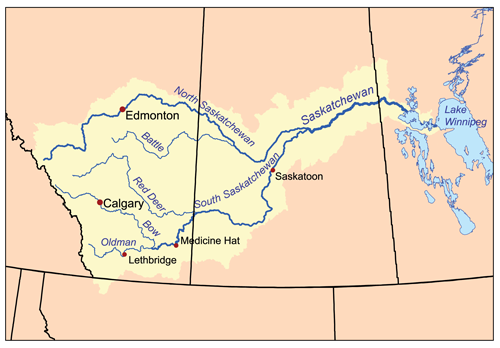
map_caption = The Saskatchewan River drainage basin
footnotes =The South Saskatchewan River (French: "rivière Saskatchewan Sud") is a major river in
Canada that flows through the provinces ofAlberta andSaskatchewan .For the first half of the 20th century, the South Saskatchewan would completely freeze over during winter, creating spectacular ice breaks and dangerous conditions in Saskatoon and elsewhere. At least one bridge in Saskatoon was destroyed by ice carried by the river. The construction of the
Gardiner Dam in the 1960s, however, lessened the power of the river and by the 1980s many permanentsandbar s had formed due to the lowering of the level of the river.From the headwaters of the
Bow River , the South Saskatchewan flows for km to mi|1392. At its mouth atSaskatchewan River Forks , it has an average discharge of 280 m³/s, and has a watershed of 146,100 km², 1,800 of which are inMontana in theUSA , and 144,300 km² in Alberta and Saskatchewan. [Cite web| url= http://atlas.nrcan.gc.ca/site/english/learningresources/facts/rivers.html |author= Atlas of Canada | authorlink= Atlas of Canada | title= Rivers in Canada| accessdate= 2007-05-01
(Webpage shows that the South Saskatchewan River has a much higher flow than the Saskatchewan River. But since the South is a tributary of the Saskatchewan River, it must be assumed that the data is reversed.)]Course
The river originates at the confluence of the Bow and
Oldman River s near "Grassy Lake". The waters of these two rivers, in turn, originate fromglacier s in theRocky Mountains near theBritish Columbia border.The reservoir was created with the construction of the Gardiner and Qu'Appelle River
dam s inSaskatchewan . Water from the South Saskatchewan flowing through the dams provides much of the electricity in the province.Downstream from the dam the river flows north through Saskatoon and joins the
North Saskatchewan River east of Prince Albert at theSaskatchewan River Forks — thus forming theSaskatchewan River . For approximately 60 km near Saskatoon, theMeewasin Valley Authority is responsible for conservation of the river environment.Numerous lakes in the Saskatoon area were formed by oxbows of the South Saskatchewan River, most notably Moon Lake and Pike Lake.
Tributaries
*Bow
*Oldman River
*Seven Persons Creek
*Red Deer River
*Teepee Creek
*Landing Creek
*Smith Creek
*Valentine Creek
*Pine Lake Creek
*Brightwater Creek
*Beaver Creek (Saskatchewan)
*Fish Creek, Saskatchewan References

Wikimedia Foundation. 2010.