- Ramsgate
-
For other uses, see Ramsgate (disambiguation).
Coordinates: 51°20′38″N 1°24′15″E / 51.343910°N 1.404030°E
Ramsgate 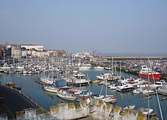
The Royal Harbour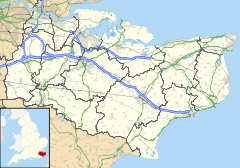
 Ramsgate
Ramsgate shown within KentPopulation 39,639 (2001 Census) OS grid reference TR382648 Parish Ramsgate District Thanet Shire county Kent Region South East Country England Sovereign state United Kingdom Post town RAMSGATE Postcode district CT11 Dialling code 01843 Police Kent Fire Kent Ambulance South East Coast EU Parliament South East England UK Parliament South Thanet List of places: UK • England • Kent Ramsgate is a seaside town in the district of Thanet in east Kent, England. It was one of the great English seaside towns of the 19th century and is a member of the ancient confederation of Cinque Ports. It has a population of around 40,000. Ramsgate's main attraction is its coastline and its main industries are tourism and fishing. The town has one of the largest marinas on the English south coast and Port of Ramsgate has provided cross channel ferries for many years.
Contents
History
Main article: History of Ramsgate Ramsgate Sands in 1854
 Photochrom of The sands, 1899
Ramsgate began as a fishing and farming hamlet. Ramsgate as a name has its earliest reference as "Hraefn's gate", or "raven's cliff gap",[1][2][3] later to be rendered 'Ramisgate' or 'Remmesgate' around 1225 and 'Ramesgate' from 1357. The legendary mercenaries Hengest and Horsa landed in the 5th century to herald the pagan Anglo-Saxon age in England. The Christian missionary St. Augustine landed in Ramsgate in 597 which re-established the link between England and the Christian church in Rome.
Ramsgate's harbour is a defining characteristic of the town. The construction of Ramsgate Harbour began in 1749 and was completed in about 1850. The Harbour has the unique distinction of being the only Royal Harbour in the United Kingdom. Because of its proximity to mainland Europe, Ramsgate was a chief embarkation point both during the Napoleonic Wars and for the Dunkirk evacuation in 1940.
In 1901, the Isle of Thanet saw the introduction of an electric tram service which was one of the few inter-urban tramways in Britain. The towns of Ramsgate, Margate and Broadstairs were linked by 11 miles of track.
In 1915-1916 early aircraft began to use the open farmlands at Manston as a site for emergency landings. The location near the Kent coast gave Manston some advantages over the other previously established aerodromes. During the first World War, Ramsgate was the target of bombing raids by Zeppelin airships. By 1917 the Royal Flying Corps was well established and taking an active part in the defence of England. As RAF Manston the aerodrome played an important role in the second World War and is now called Kent International Airport.
Geography
 A map of Ramsgate from 1945
Ramsgate is located 78 miles from central London in an East South Easterly direction at one of the most Easterly points of the country (the furthest point east is Lowestoft in Suffolk). Ramsgate has its own meridian line and Mean Time which is 5 minutes 41 seconds ahead of Greenwich Mean Time. Ramsgate is about 1 hour from the M25.
The town is now the amalgamation of two settlements. One is the fishing community based on the coast in the shallow valley between two chalk cliffs and the other a farming community inland that is now the Parish of St. Lawrence. The cliffs are now known as the East Cliff and the West Cliff and are predominantly residential areas. There are promenades along both cliff tops with parks at either end and sand beaches on the coast.
Climate
Ramsgate experiences an oceanic climate (Köppen climate classification Cfb) as is typical in the United Kingdom; the nearest Met Office weather station for which data is available is Manston airport, about 2 miles west of the town centre.
The absolute maximum temperature attained is 34.6c(94.3f)[4] set in August 2003, though typically the warmest day of the year averages out at 28.5c(83.3f)[5] and 8.8 days[6] will record a temperature of 25.1c(77.2f) or above.
The absolute minimum temperature stands at -14.5c(5.9f)[7], set in February 1986, though typically the coldest night of the year averages -6.2c(20.8f)[8]. A total of 28.9 days[9] of the year should record an air frost.
Rainfall averages around 550mm[10] per year, a level similar to the driest parts of England. Over 1mm of rain can be expected on 102.9 days.[11] All averages refer to the 1971-00 period.
Being close to the coast, and in Southern England, sunshine compares favourably with most of the United Kingdom, at over 1700 hours[12] a year. Only the Sussex coast tends to be notably sunnier, although much of the remainder of the south coast receives a similar amount of sunshine as Ramsgate.
Climate data for Manston, elevation 49m, 1971-2000, extremes 1960- Month Jan Feb Mar Apr May Jun Jul Aug Sep Oct Nov Dec Year Record high °C (°F) 16.4
(61.5)16.8
(62.2)20.2
(68.4)25.0
(77.0)29.6
(85.3)31.2
(88.2)31.4
(88.5)34.6
(94.3)29.6
(85.3)24.9
(76.8)18.0
(64.4)15.9
(60.6)34.6
(94.3)Average high °C (°F) 7.1
(44.8)7.2
(45.0)9.8
(49.6)11.8
(53.2)15.5
(59.9)18.5
(65.3)21.1
(70.0)21.5
(70.7)18.6
(65.5)14.6
(58.3)10.4
(50.7)8.2
(46.8)13.69
(56.65)Average low °C (°F) 1.9
(35.4)1.7
(35.1)3.3
(37.9)4.9
(40.8)8.0
(46.4)10.7
(51.3)13.2
(55.8)13.4
(56.1)11.3
(52.3)8.4
(47.1)4.7
(40.5)3.1
(37.6)7.05
(44.69)Record low °C (°F) −12
(10)−14.5
(5.9)−6
(21)−3.7
(25.3)−1.1
(30.0)0.9
(33.6)6.4
(43.5)5.4
(41.7)2.2
(36.0)−3.1
(26.4)−6
(21)−8.8
(16.2)−14.5
(5.9)Precipitation mm (inches) 45.32
(1.7843)30.95
(1.2185)37.90
(1.4921)41.04
(1.6157)39.85
(1.5689)46.65
(1.8366)39.34
(1.5488)39.54
(1.5567)59.27
(2.3335)64.76
(2.5496)59.08
(2.326)51.00
(2.0079)554.72
(21.8394)Sunshine hours 62.55 80.33 118.96 171.51 222.17 216.47 222.08 226.80 157.88 119.06 75.01 52.6 1,722.02 Source no. 1: YR.NO[13] Source no. 2: KNMI[14] Governance
Ramsgate is in the parliamentary constituency of Thanet South represented by Conservative MP Laura Sandys who won the seat in the 2010 general election.
Before 6 May 2010 the MP was Stephen Ladyman a senior Labour minister, preceded by Jonathan Aitken.
Ramsgate was incorporated as a municipal borough in 1884. This was abolished in 1974, since which date Ramsgate has been within the Thanet local government district. The town contains the seven electoral wards of Central Harbour, Cliffsend and Pegwell, Eastcliff, Nethercourt, Newington, Northwood, and Sir Moses Montefiore. These wards have seventeen of the fifty-six seats on the Thanet District Council; as of 2011 fifteen of those seats were held by Labour and two by the Conservatives [15]
Following a successful campaign by local activist Gerry O'Donnell, a Ramsgate Town Council was established in June 2009.[citation needed] The Town Mayor of Ramsgate is currently Cllr David Green.[16]
Economy
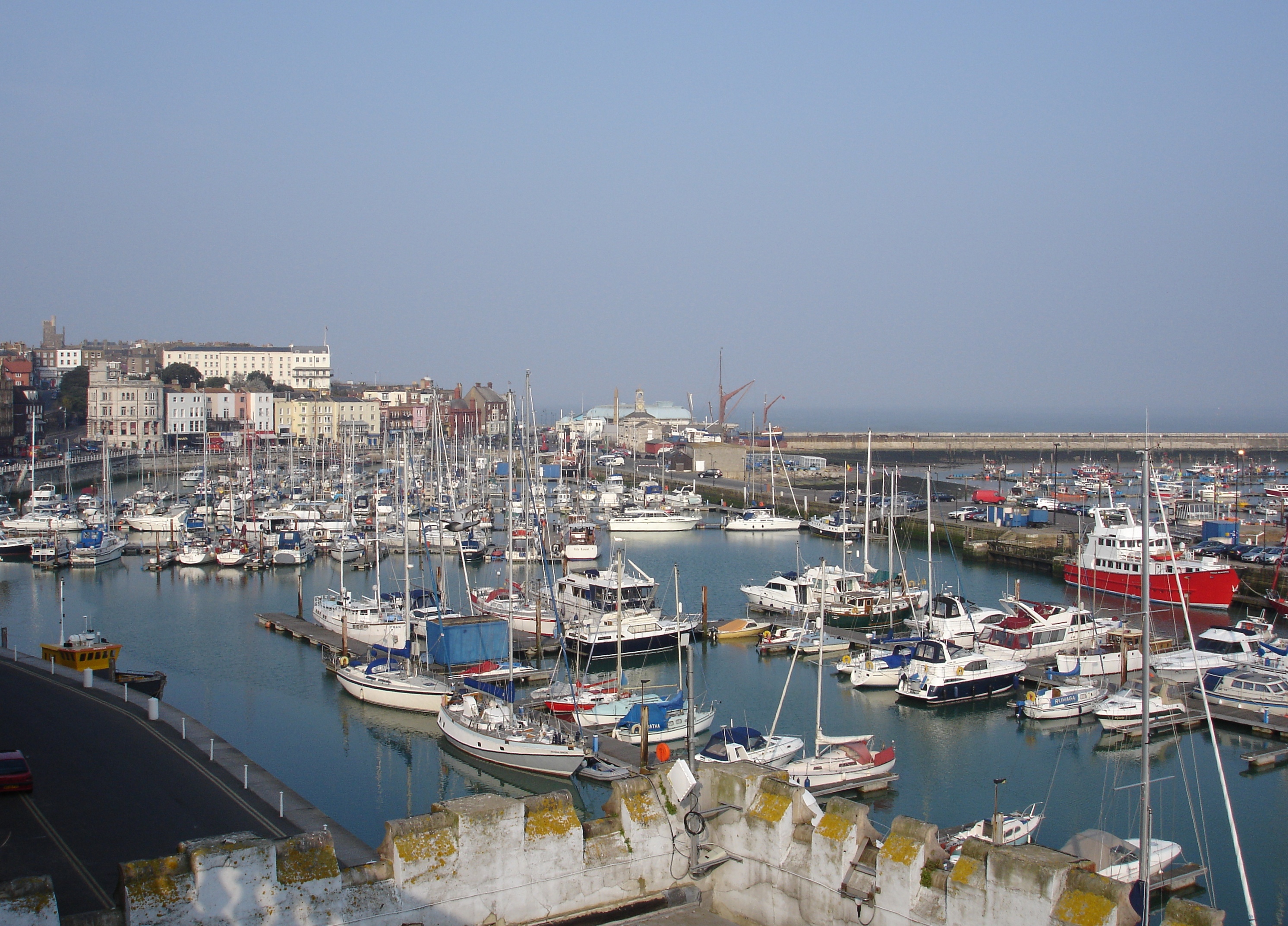
 Ramsgate marina, location of many popular bars and pubs
Ramsgate's main industries are tourism and fishing. The town has a thriving marina with over 800 moorings and a range of marine-related businesses that operate in premises in the renovated arches under Royal Parade. The town caters for students of EFL (English as a foreign language) at its colleges.
Although Ramsgate has the most valuable fish landings in Kent (~£700,000 in 2003), the fishing industry is in decline.[17]
Port of Ramsgate has provided cross channel ferries for many years. Previously Sally Ferries UK provided a service of passenger and car ferries to Dunkirk. Currently a service of freight and car is provided to Oostende by the company Transeuropa Ferries.
Unemployment for Thanet is higher (4.1%) than the national average (2.5%).[18]
There is some light industry in the town. An emerging industry is power generation, with 800 jobs expected to be created by the Thanet offshore wind project, a wind farm just off the coast.
Ramsgate Market is held in High Street, King Street and Queen Street every Friday and Saturday between 8a.m. and 4p.m.[19]
Demographics
Ramsgate Compared 2001 UK Census Ramsgate Thanet District England Total population 39,639 126,702 49,138,831 Foreign born 4.4% 5.1% 9.2% White 98% 98% 91% Asian 0.7% 0.6% 4.6% Black 0.3% 0.3% 2.3% Christian 72% 74% 72% Muslim 0.3% 0.5% 3.1% Hindu 0.1% 0.2% 1.1% No religion 18% 16% 15% Over 65 years old 18% 22% 16% As of the 2001 UK census, Ramsgate had a population of 39,639.[20]
The ethnicity of the town was 98.0% white, 0.8% mixed race, 0.3% black, 0.3% Chinese, 0.4% other Asian and 0.1% other ethnicity.[20]
The place of birth of residents was 95.6% United Kingdom, 0.7% Republic of Ireland, 0.6% Germany, 0.6% other Western Europe countries, 0.3% Eastern Europe, 0.6% Far East, 0.5% Africa, 0.3% North America, 0.3% South Asia, 0.2% Middle East, 0.2% Oceania and 0.1% South America[20]
Religion was recorded as 71.6% Christian, 0.3% Muslim, 0.1% Hindu, 0.3% Buddhist, 0.1% Sikh and 0.1% Jewish. 17.9% were recorded as having no religion, 0.3% had an alternative religion and 7.1% didn't state their religion.[20]
For every 100 females, there were 91.2 males. The age distribution was 6% aged 0–4 years, 16% aged 5–15 years, 5% aged 16–19 years, 31% aged 20–44 years, 24% aged 45–64 years and 18% aged 65 years and over.[20]
Culture
Tourism
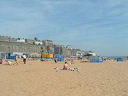 Ramsgate Main Sands
Ramsgate's main attraction is its coastline, particularly Ramsgate Main Sands, which has been awarded a 2008 Blue Flag award. The water quality, tested in 2007, passed the legal minimum, mandatory standard.[21]
The local council publishes a website specifically aimed at tourists visiting Ramsgate and neighbouring towns.[22]
The previous prime seafront site which was Ramsgate pleasure park is currently undergoing major redevelopment.[23]
Ramsgate has developed a continental cafe style culture with bars and restaurants on its seafront parade.[citation needed]
There is an annual Powerboat Grand Prix event based out of the harbour of Ramsgate during the summer. Ramsgate carnival is an annual parade also during the summer.[24] Other events include the annual Addington Street Fair and the French Market.[citation needed]
Sports
Thanet Wanderers is the island's only rugby team, which has enjoyed recent success at London Division 1 level and achieved its best result in defeating Doncaster at Twickenham in the final of the intermediate cup in 1997. The club runs five senior sides and many junior teams. The sides play at St Peters. Ramsgate's main football club, Ramsgate F.C., plays in the Isthmian League Premier Division. The main local rivals of the club are Margate F.C. who are situated 4 miles away. When the two teams meet, it is known as the Thanet derby. Ramsgate have achieved The FA’s Charter Standard "Development" award. Ramsgate also run a Reserves Team which plays in Kent Football League Second Division, a women's team which plays in South East Counties Women's League Kent County Division.
Ramsgate F.C. also run five main youth teams, under-13 to under-18 all feature in the Valley Express Kent Youth League and also run Ramsgate Youth U7 to U16 who play in The Molten East Kent Youth League; two other popular youth teams who are based in Ramsgate are Trinity & Hugin Vikings both also play in The Molten East Kent Youth League.
Thanet Galaxy is a Pan Disability Football Club. They provide structured coaching for male and female footballers of all ages who qualify within the nationally and internationally recognised Pan Disability categories they Train at Chatham House Grammer School and play in Kent Disability Football League, They play and train in three age bands: U-11, U-16, 16+. In their first season, 2008/2009, the Adult A Team won the Kent Disability League Adult Championship.
Ramsgate's sports facilities include a public swimming pool,[25][26] a fitness centre[27] with gym and sports hall. Tennis clubs can be found at Spencer square and St. Laurence. Ramsgate has three golf clubs: St. Augustines,[28] Stonelees,[29] and Manston.[30] Being a harbour town, there is also a sailing club - The Royal Temple Yacht Club. The Royal Temple Yacht Club is steeped in yacht racing history, and hosts racing throughout the year for a variety of historic trophies. The highlight of the season is the annual international sailing regatta - 'Ramsgate Week', usually held in August.[31]
Arts and local media
The Gallery IOTA (Isle Of Thanet Arts) was based on the towns west cliff but is now on the harbour front.[32] Ramsgate Maritime Museum near the harbour quayside has exhibits showing the evolution of Ramsgate Harbour and East Kent maritime history. Ramsgate's sole cinema and theatre is the Granville Cinema, situated on Victoria Parade, in the town's Eastcliff area.
Ramsgate has two paid for newspapers, the Isle of Thanet Gazette and Thanet Times which are owned by Northcliffe Media.[33] Free newspapers for the town include the Thanet Extra, part of the KM Group; and yourthanet, part of KOS Media.
Local radio stations are KMFM Thanet, owned by the KM Group, community radio station Academy FM (Thanet); and the county-wide stations Heart Kent, Gold and BBC Radio Kent. Thanet Community Radio (TCR [34] offer an online arts and features based service for Thanet District and the surrounding area where people can listen to pod-casts of local interest. The service works closely with Dover district based Dover Community Radio.
Landmarks
 The Hugin Viking longship in Pegwell.
The Hugin is a reconstructed Viking longship located at Pegwell Bay in Ramsgate. It was a gift from the Danish government in commemoration of the 1500th anniversary of the arrival of Hengist and Horsa to the country in 449.
Architecture
Main article: Historic Buildings in RamsgateMany buildings in Ramsgate are of Regency and Victorian architecture. There are 900 listed buildings in the town with more than 200 surrounding the Marina.[35]
The town has three notable churches. The first building used for worship in the Thanet parish of 'St Lawrence' was at St Laurence-in-Thanet, built in 1062 and rebuilt during the following centuries with the most significant changes being in the 16th century. Note the difference in spelling between that of the Village of St Lawrence and the church, which is dedicated to the Roman Martyr, Laurence.
The second notable church is St Augustine's, which is situated on the town's westcliff. Considered one of the most August and distinct surviving it was designed by Augustus Pugin in 1847 in the neo-Gothic style. Its dedication commemorates Augustine, the first Archbishop of Canterbury, who landed at Ramsgate in AD 596 and brought Christianity to Britain.
Thirdly, the town's Parish Church of St George is situated just off the town's High Street. Its lantern tower was added at the request of Trinity House as a navigational aid to passing ships and looks over the town. The ground was consecrated on 23 October 1827.
St Augustine' serves its own abbey and the town's Catholic community, whilst St Laurence and St George are both Church of England, and serve the Anglican community as part of the Diocese of Canterbury. Christ Church [1] built in 1847 also serves the Anglican community.
Ramsgate library was originally built and paid for by Andrew Carnegie in 1904. On the evening of Friday 13 August 2004 a fire destroyed Ramsgate library just two months short of its 100th anniversary. Though suspicions were raised as to what started the fire due to a similarly timed fire at the towns registry office, an investigation concluded that the blaze was too intense to pinpoint where and how the fire started.
Shortly after the blaze, planning permission was granted for a new library. The library has now been fully restored, and was officially re-opened on 20 February 2009. [2]
Transportation
By sea
Main article: Port of RamsgateThe Port of Ramsgate has a 700 berth marina, Royal Harbour Marina, and a ferry terminal built on reclaimed land. The harbour provides shelter from the effect of storms. The Goodwin Sands are nearby. In 2005, the marina had 12,000 visiting boats.[citation needed] Transeuropa Ferries passenger (with vehicle only) and freight ferries now sail to the Port of Ostend in Ostend, Belgium. The Port of Ramsgate has its own road access tunnel from outside of the town, avoiding town centre congestion. The RNLI Ramsgate Lifeboat Station is based in Ramsgate Harbour.
By road
Ramsgate is connected to the national road network primarily through the A299 Thanet Way which continues onto the M2/A2 for the M25 (approx 1 hour) and London. The A256 provides a link to Dover and onwards onto the A20 for the Channel Tunnel. Bus services are provided by Stagecoachbus' "Thanet Loop" scheme.
By rail
Main article: Ramsgate railway stationRamsgate railway station is situated at the top of the town near the parish of St Lawrence.
A new high-speed service to London started in December 2009, running on High Speed 1 (HS1), the UK’s first high speed rail line, between London’s St. Pancras station and Kent. The journey time from Ramsgate to the new St. Pancras terminal, with excellent transport links, is 1 hour and 16 minutes.[36]
Other trains run from Ramsgate to London Charing Cross and London Victoria. Commuting time to the capital on these lines is approximately 1 hour 50 minutes.
Trains from Ramsgate pass via Margate, Chatham and Bromley South, or via Canterbury West or Dover Priory and Ashford International. Ramsgate railway station is operated by Southeastern.
By air
Main article: Ramsgate AirportA municipal airport was opened on 1 July 1935, operating until the Second World War broke out in 1939. Following a short spell as a satellite of RAF Manston, it closed in 1940. The airport was re-opened in 1952 and operated until closure in 1968.
Main article: Kent International AirportThe town is situated directly under the flight path of Kent International Airport at Manston. From September 2004 to August 2005 a low-cost airline EUjet operated frequent flights to many European destinations, replacing a large freight operator. However, flights were suspended after the collapse of its parent company, PlaneStation Group plc.[37]
Manston was sold to Infratil (owner of Glasgow Prestwick International Airport) on 26 August 2005. As of 2011, Flybe operates flights from the airport to Edinburgh and Belfast and is regularly used by freight operators such as Cargolux and Meridian.
Education
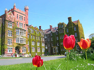 St Lawrence College private school in Ramsgate
Infant schools
- Dame Janet Infant School
- Ellington Infants School
- Priory Infants School
Junior schools
- Christ Church C Of E Junior School
- Dame Janet Junior School
- St Ethelbert's R C Junior Mixed & Infants School
- St Laurence-in-Thanet CE Junior School
Primary schools
- Newington Community Primary School.
- Newlands Primary School
- Chilton County Primary School
Secondary schools
- Chatham House Grammar School
- Clarendon House Grammar School
- Ellington High School
- The Marlowe Academy
- St Lawrence College
The Marlowe academy failed the 30% GCSE target.[38][39]
Colleges and further education
- Ramsgate's nearest college is Thanet College. This is situated in the nearby town of Broadstairs. There is also a campus for Canterbury Christ Church University which is situated in Broadstairs which is within very easy reach of Ramsgate.
Affiliations
Twin cities/towns:
See also
These are internal links associated with Ramsgate
-
-
-
- The Grange, Ramsgate Home of the Victorian architect and designer August Pugin.
- Montefiore Synagogue Private synagogue of Sir Moses Montefiore.
- Townley House Queen Victoria used to stay here on summer holidays as a child.
- Chatham House Grammar School Founded in 1797 as a boarding school by William Humble
-
- Port of Ramsgate
-
- Ramsgate Maritime Museum Situated in the Clock House in Ramsgate harbour.
-
- ST Cervia (1946 Tugboat) The Steam Tug (ST) Cervia was originally named Empire Raymond.
- Sundowner (yacht) Motor yacht owned by Charles Lightoller, 2nd Officer of RMS Titanic.
- Ramsgate lifeboat station Provides an inshore boat and an offshore boat.
-
- Ramsgate Harbour railway station
- Ramsgate Town railway station
- Ramsgate Cliff Railway
- Ramsgate F.C. Football team based in Ramsgate.
- List of people from Thanet#Ramsgate
-
Notes
- ^ Concise Dictonary World place names, Oxford Uni. Press: 2005
- ^ A Dictonary of British Place names 2003: A.D Mills
- ^ encyclopedia.com: OED etymology of "raven"
- ^ "2003 Maximum". http://eca.knmi.nl/utils/monitordetail.php?seasonid=14&year=2003&indexid=TXx&stationid=1862. Retrieved 2011-03-01.
- ^ "Annual average warmest day". http://eca.knmi.nl/utils/calcdetail.php?seasonid=0&periodid=1971-2000&indexid=TXx&stationid=1862. Retrieved 2011-03-01.
- ^ "Average >25c days". http://eca.knmi.nl/utils/calcdetail.php?seasonid=0&periodid=1971-2000&indexid=FD&stationid=1862. Retrieved 2011-03-01.
- ^ "1986 Minimum". http://eca.knmi.nl/utils/monitordetail.php?seasonid=8&year=1986&indexid=TNn&stationid=1862. Retrieved 2011-03-01.
- ^ "Annual average coldest night". http://eca.knmi.nl/utils/calcdetail.php?seasonid=0&periodid=1971-2000&indexid=TNn&stationid=1862. Retrieved 2011-03-01.
- ^ "Air frost average". http://eca.knmi.nl/utils/calcdetail.php?seasonid=0&periodid=1971-2000&indexid=FD&stationid=1862. Retrieved 2011-03-01.
- ^ "Annual average rainfall". http://eca.knmi.nl/utils/calcdetail.php?seasonid=0&periodid=1971-2000&indexid=RR&stationid=1862. Retrieved 2011-03-01.
- ^ "Annual average raindays". http://eca.knmi.nl/utils/calcdetail.php?seasonid=0&periodid=1971-2000&indexid=RR1&stationid=1862. Retrieved 2011-03-01.
- ^ "1971-00 Sunshine". http://eca.knmi.nl/utils/calcdetail.php?seasonid=0&periodid=1971-2000&indexid=SS&stationid=1862. Retrieved 2011-03-01.
- ^ "Climate Normals 1971–2000". YR.NO. August 2011. http://www.yr.no/place/United_Kingdom/England/Margate/statistics.html. Retrieved 01 mar 2011.
- ^ "Climate Normals 1971–2000". KNMI. http://eca.knmi.nl/utils/mapserver/climatology.php?indexcat=**&indexid=**&periodidselect=1971-2000&seasonid=0&scalelogidselect=no&CMD=ZOOM_IN#bottom. Retrieved 01 mar 2011.
- ^ "Council & Democracy". Thanet District Council. http://tdc-mg-dmz.thanet.gov.uk/mgMemberIndex.aspx?FN=PARTY&VW=LIST&PIC=0. Retrieved 2011-07-27.
- ^ Contact the Mayor
- ^ http://www.coastalkent.net/data/fact/document/Fisheries.pdf
- ^ "Unemployment figures for February 2006, Thanet District Council". Archived from the original on 2006-09-27. http://web.archive.org/web/20060927080904/http://www.thanet.gov.uk/business/unemployment_figures.aspx. Retrieved 2006-12-08.
- ^ http://www.thanet.gov.uk/council__democracy/thanet_fact_file/markets.aspx thanet.gov.uk
- ^ a b c d e "Neighbourhood Statistics". Statistics.gov.uk. http://neighbourhood.statistics.gov.uk/dissemination/LeadHome.do;jsessionid=ac1f930bce6a711447e60ba4446bb56c21648d42c51.e38PbNqOa3qRe38OaNeKahqMai1ynknvrkLOlQzNp65In0?bhcp=1. Retrieved 2007-03-29.
- ^ Blue Flag - Home
- ^ Welcome to Thanet: Broadstairs, Ramsgate and Margate
- ^ Royal Sands Marina Esplanade, Ramsgate
- ^ Ramsgate Carnival
- ^ Ramsgate swimming pool is around 30 years old and will be rebuilt
- ^ http://www.leisureforce.co.uk/indoor/ramsgate_swim/facilities/default.asp
- ^ http://www.leisureforce.co.uk/indoor/ramsgate_sports/facilities/default.asp
- ^ St. Augustines Golf Club
- ^ Stonelees Golf Club
- ^ Manston Golf Club
- ^ Ramsgate Yacht Club
- ^ Gallery IOTA
- ^ http://www.northcliffemedia.co.uk/our-regions/south-east
- ^ http://www.thanetcommunityradio.co.uk
- ^ Ramsgate Focus
- ^ Southeastern 2009 - your journey starts here : Home
- ^ "Airline goes into administration". BBC News. 26 July 2005. http://news.bbc.co.uk/1/hi/england/kent/4717881.stm. Retrieved 22 May 2010.
- ^ "Schools below 30% GCSE target". BBC News. 9 June 2008. http://news.bbc.co.uk/1/hi/education/7444059.stm. Retrieved 22 May 2010.
- ^ "BBC News, School league tables 2007, Kent LA". BBC News. http://news.bbc.co.uk/1/shared/bsp/hi/education/07/school_tables/secondary_schools/html/886_6906.stm. Retrieved 22 May 2010.
Bibliography
- Martin Easdown, A Fateful Finger of Iron: The Story of the Ill-fated Ramsgate Promenade Pier Within a Resort History of the Town, Michaels Bookshop (Jul 2006), ISBN 1-905477-65-1
- Bob Simmonds, Ramsgate From the Ground: An Alternative Look at the Town and Its History, Michaels Bookshop (April 2006), ISBN 1-905477-47-3
External links
Towns and villages in the Thanet district of Kent, England 
Unparished areas Civil parishes Other settlements - Broadstairs
- Brooks End
- Cliftonville
- Ebbsfleet
- Flete
- Garlinge
- Newington
- Palm Bay
- Sevenscore
- St Peters
- Westbrook
- Westgate-on-Sea
- Westwood
Ceremonial county of Kent Unitary authorities Boroughs or districts Major settlements - Ashford
- Broadstairs
- Canterbury
- Chatham
- Cranbrook
- Dartford
- Deal
- Dover
- Edenbridge
- Faversham
- Folkestone
- Fordwich
- Gillingham
- Gravesend
- Greenhithe
- Herne Bay
- Hythe
- Lydd
- Maidstone
- Margate
- Minster
- New Romney
- Northfleet
- Paddock Wood
- Queenborough
- Rainham
- Ramsgate
- Rochester
- Royal Tunbridge Wells
- Sandwich
- Sevenoaks
- Sheerness
- Sittingbourne
- Snodland
- Southborough
- Strood
- Swanley
- Swanscombe
- Tenterden
- Tonbridge
- Walmer
- West Malling
- Westerham
- Westgate-on-Sea
- Whitstable
See also: List of civil parishes in Kent
Rivers See: Rivers of KentTopics Categories:- Thanet
- Ramsgate
- Seaside resorts in England
- Towns in Kent
- Ports and harbours of the English Channel
- Ports and harbours of Kent
- Cinque ports
- Populated coastal places in Kent
- Civil parishes in Kent


Wikimedia Foundation. 2010.