- Ma'alot-Tarshiha
-
Ma'alot-Tarshiha Hebrew transcription(s) – Hebrew מַעֲלוֹת-תַּרְשִׁיחָא – ISO 259 Maˁlot Taršiḥaˀ – Translit. Maʻalot-Tarshiḥa Arabic transcription(s) – Arabic معالوت ترشيحا, Maʻālūt Taršīḥā Maalot Tarshiha.jpg

Logo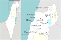
 Ma'alot-Tarshiha
Coordinates: 33°1′N 35°16′E / 33.017°N 35.267°ECoordinates: 33°1′N 35°16′E / 33.017°N 35.267°E District North Government – Type City (from 1996) – Mayor Shlomo Bohbot Area – Total 6,832 dunams (6.8 km2 / 2.6 sq mi) Population (2009)[1] – Total 20,600 Ma'alot-Tarshiha (Hebrew: מַעֲלוֹת-תַּרְשִׁיחָא; Arabic: معالوت ترشيحا) is a mixed city in the North District in Israel, some 20 km east of Nahariya, about 600 meter above sea level. The city was established in 1963 through a municipal merger of the Arab town of Tarshiha and the Jewish town of Ma'alot. According to the Israel Central Bureau of Statistics (CBS), in December 2009 the city had a total population of 20,600.[1]
Contents
History
Tarshiha
Tarshiha is believed to have been built on the site of a Canaanite settlement, Haki[citation needed], dating back to the 2nd-3rd millennium BC. Excavations of a 4th century burial cave in the village unearthed a cross and a piece of glass engraved with a menorah.[2][citation needed]
Crusader sources from the (12th and 13th century) refer to Tarshiha as Terschia, Torsia and Tersigha.[3] During the Crusader period, Tarshiha was the site of battles between Christians and Arabs. According to popular Arabic etymology (no reference), the name may have meant "Artemisia Mountain" in the Canaanite language, where Arabic Tuur for "mountain" and shiiH for "artemisia" (mugwort, or common wormwood) could be identified, or alternatively from Taar shiiHaa ("Shiha flew"), i.e. Shiha Jamaluddin (a legendary hero) rushed to the battlefield to fight the Crusaders.
In 1573, under the Ottoman Empire, the village of Tarshiha was raided by the Lebanese feudal chief, Mansur ibn Furaykh.[4] The daftar of 1596 show the village to be under the administration of the nahiya of Akka, with a population of 110 households ("khana"). The inhabitants paid taxes on "occasional revenues", bees and goats. The village was also taxed for a press, used either of olives or for grapes.[5] In the early eighteenth century, the village was under control of Shaikh Husayn,[6] while later in the Ottoman period it became one of the major cotton-producing villages of Galilee, and the administrative center of the nahiya.[7]
V. Guérin wrote in the 1860s that the principal mosque in Tarshiha had been built by Abdullah Pasha, (the Governor of Acre at the time.)[8] In the "Survey of Western Palestine" in the latter part of the nineteenth century, Tarshiha was described as: "a very large village, containing about 1,500 Moslems and 300 Christians; there is a fine mosque with minarets newly built, also an old one; the houses are well-built; a new and handsome church has been built in the Christian quarter".[9]
Tarshiha was in the territory allotted to the Arab state under the 1947 UN Partition Plan.[10] However, in the 1948 Arab-Israeli War, the village was captured by the Israel Defense Forces in Operation Hiram on October 29, by which time a large part of Tarshiha's Arab population had fled to Lebanon.[11]
Ma'alot
 Ma'alot-Tarshiha city hall
Ma'alot was established as a development town for Jewish immigrants from Romania, Iran, Lebanon and Morocco, in 1957. The first homes were built on Har HaRakafot (Cyclamen Hill), known in Arabic as Bab Al-Hauwa ("Gate of the Winds").[12] In 1963, Ma'alot was merged with the larger Tarshiha, and the unified town was renamed to reflect both origins. The inhabitants of Tarshiha hoped that the merger would improve the level of services.
On 15 May 1974, an elementary school in Ma'alot was attacked by terrorists of the Democratic Front for the Liberation of Palestine in what became known as the Ma'alot massacre.[13] Twenty-one teenagers from Safed on a class trip were murdered in the attack. They had been sleeping on the floor inside the building.[14]
Ma'alot-Tarshiha was officially recognized as a city in 1996.
Second Lebanon War
Nearly 700 Katyusha rockets landed in the vicinity of Ma'alot-Tarshiha during the Second Lebanon War. Three Arab residents of the city were killed in a rocket attack.[15]
Demographics and income
In 2001, ethnic and religious makeup of the city was 79.7% Jewish and other non-Arabs, and 20.0% Arab (8.9% Muslim, 9.9% Christian, and 1.0% Druze). In the early 2000s, 52% of the population were Russian immigrants. In 2001, there were 10,100 males and 10,100 females. The population of the city was diverse in age with 35.7% 19 years of age or younger, 15.3% between 20 and 29, 20.4% between 30 and 44, 14.6% from 45 to 59, 3.9% from 60 to 64, and 10.0% 65 years of age or older. The population growth rate in 2001 was 3.0%.
As of 2000, CBS reported there were 6,931 salaried workers and 408 self-employed persons in the city. The mean monthly wage in 2000 for a salaried worker was NIS 4,435, a real change of 7.0% over the course of 2000. Salaried men had a mean monthly wage of NIS 5,652 (a real change of 9.9%) versus NIS 3,073 for women (a real change of 2.0%). The average income for the self-employed was NIS 6,320. There were 559 people who received unemployment benefits, and 1,785 people who received an income guarantee.
Economy
 Ma'alot hotel
The Iscar plant and industrial parks built in the vicinity of Ma'alot-Tarshiha by Stef Wertheimer are major sources of employment for the city's residents. In 2007, the jobless rate in Ma’alot-Tarshiha was 5.5 percent, compared to 7.9 percent nationally.[16]
Education
In 2001, there were 11 schools and 4,272 students in the city, including 7 elementary schools with an enrollment of 2,000, and 7 high schools with 2,272 students. 58.5% of the city's 12th graders earned a matriculation certificate in 2001. In August 1975, Yeshivat Ma'alot, a Hesder yeshiva, was established, attracting students from all over the world.
Landmarks and culture
 Monfort Lake, Ma'alot
Lake Monfort, an artificial lake to the east of Ma'alot-Tarshiha, has become a local tourist attraction. It was previously known as the Hosen Reservoir. The lake is featured in the city's emblem.[17]
In January 2008, Ma'alot-Tarshiha hosted the Israel International Chess Championship. The tournament, held at the community center, carried a prize of $20,000. The city has also hosted other international events, among them an international fencing tournament.[18] The "Stone in the Galilee" International Sculpture Symposium has been held annually in Ma'alot-Tarshiha since 1991. In this 10-day springtime event, sculptors from Israel and around the world convene at Montfort Lake to create stone sculptures from huge blocks of stone.[2]
Twin Towns — Sister Cities
 Birobidzhan, Russia
 Harrisburg, Pennsylvania
References
- ^ a b "Table 3 - Population of Localities Numbering Above 2,000 Residents and Other Rural Population". Israel Central Bureau of Statistics. 2010-06-30. http://www.cbs.gov.il/population/new_2010/table3.pdf. Retrieved 2010-10-31.
- ^ a b "Ma'alot". B&B Israel. http://www.bb-israel.com/content_items.php?id=185&tour=1. Retrieved 2008-10-25.
- ^ Gutterman, Dov. "Ma'alot-Tarshiha (Israel)". Flags of the World. http://www.fotw.net/flags/il-matsh.html. Retrieved 2008-10-25.
- ^ Petersen, 2002, p.293
- ^ Hütteroth, Wolf-Dieter and Kamal Abdulfattah (1977), Historical Geography of Palestine, Transjordan and Southern Syria in the Late 16th Century. Erlanger Geographische Arbeiten, Sonderband 5. Erlangen, Germany: Vorstand der Fränkischen Geographischen Gesellschaft. p. 192. Quoted in Petersen, 2002, p. 293-4
- ^ Cohen, 1973, p. 9. Quoted in Petersen, 2002, p. 294
- ^ Cohen, 1973, p. 12, 121. Quoted in Petersen, 2002, p. 294
- ^ Guérin, cited in Conder and Kitchener, 1881, p.149, and Petersen, 2002, p.294
- ^ Conder and Kitchener, 1881, p.149
- ^ United Nations. Palestine Plan of Partition (Map). http://domino.un.org/maps/m0103_1b.gif. Retrieved 2008-10-25.
- ^ "Tour and Signposting in Tarshiha". Zochrot. 2006-11-11. http://www.nakbainhebrew.org/index.php?id=477. Retrieved 2008-10-25.
- ^ "Ma'alot-Tarshiha". Flags of the World. http://www.fotw.net/flags/il-matsh.html. Retrieved 2008-05-28.
- ^ "Top 10 Worst School Massacres". The List Universe. http://listverse.com/miscellaneous/top-10-worst-school-massacres. Retrieved 2008-10-25.
- ^ "1974: Dozens Die as Israel Retaliates for Ma'alot". BBC. 1974-05-16. http://news.bbc.co.uk/onthisday/hi/dates/stories/may/16/newsid_2512000/2512399.stm. Retrieved 2008-10-25.
- ^ Ben Simon, Daniel. "On TV, They Said There Were No Katyushas Left". Haaretz. https://www.haaretz.co.il/hasen/spages/876337.html. Retrieved 2008-10-25.
- ^ Sher, Hanan (November 2007). $4 Billion Man. 89. Hadassah Magazine. http://www.hadassah.org/news/content/per_hadassah/archive/2007/07_nov/feature_2.asp. Retrieved 2008-10-25.
- ^ "Ma'alot-Tarshiha (Israel)". Flags of the World. http://www.crwflags.com/FOTW/FLAGS/il-matsh.html. Retrieved 2008-10-20.
- ^ Khoury, Jack (2008-01-17). "12-Year-Old Kfar Sava Girl Defeats 20 Men (In Chess Tournament)". Haaretz. http://www.haaretz.com/hasen/spages/945444.html. Retrieved 2008-05-28.
Bibliography
- Cohen, A. (1973), Palestine in the Eighteenth Century: Patterns of Government and Administration, Hebrew University, Jerusalem. Cited in Petersen, (2002)
- Conder, Claude Reignier and H.H. Kitchener (1881): The Survey of Western Palestine: memoirs of the topography, orography, hydrography, and archaeology. London:Committee of the Palestine Exploration Fund. vol 1 (p.149 )
- Palmer, E. H. (1881): The survey of Western Palestine: Arabic and English name lists collected during the survey by Lieutenants Conder and Kitchener, R. E. Transliterated and explained by E.H. Palmer. ( p.55 )
- Petersen, Andrew (2002). A Gazetteer of Buildings in Muslim Palestine: Volume I (British Academy Monographs in Archaeology). Oxford University Press. ISBN 9780197270110. http://www.amazon.com/dp/0197270115 p. 293-296
- Robinson, Edward, Eli Smith (1841): Biblical Researches in Palestine, Mount Sinai and Arabia Petraea: A Journal of Travels in the Year 1838a, Published by Crocker & Brewster, Item notes: v. 3 (p.376)
External links
Categories:- North District (Israel)
- Cities in Israel
- Mixed Israeli communities


Wikimedia Foundation. 2010.