- South Stoke, West Sussex
-
For other uses, see South Stoke (disambiguation).
Coordinates: 50°52′49″N 0°32′34″W / 50.88021°N 0.54279°W
South Stoke 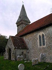
South Stoke Church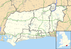
 South Stoke
South Stoke shown within West SussexArea 5.35 km2 (2.07 sq mi) [1] Population 44 [1] 2001 Census - Density 8 /km2 (21 /sq mi) OS grid reference TQ026099 - London 47 miles (76 km) NNE Parish South Stoke District Arun Shire county West Sussex Region South East Country England Sovereign state United Kingdom Post town ARUNDEL Postcode district BN18 Dialling code 01903 Police Sussex Fire West Sussex Ambulance South East Coast EU Parliament South East England UK Parliament Arundel and South Downs List of places: UK • England • West Sussex South Stoke is a small village and civil parish in the Arun District of West Sussex, England. It is located two miles (3 km) to the north of Arundel, and is situated on the west bank of the River Arun on the edge of Arundel Park. It is reached by road from Arundel. A footpath leads to North Stoke on the east bank. The civil parish, which includes the hamlet of Offham, covers an area of 534.86 hectares (1,321.7 acres) and has a population of 44 persons (2001 census). The parish church, Saxon in origin, is dedicated to St Leonard. There is one public house, the Black Rabbit at Offham.
The Monarch's Way long-distance footpath crosses the western edge of the parish between Houghton and Arundel.
The village population declined after 1806 when common land was enclosed to make Arundel Park, depriving the villagers of sheep grazing land.
The parish church
The 11th century building is recorded in the Domesday Book, when the village was named as "Stoches". Built of flint it has a thin western tower which carries a 19th century broach spire with four slatted dormer windows. There is one bell dated 1657. The porch is 13th century.
References
- ^ a b "2001 Census: West Sussex – Population by Parish". West Sussex County Council. http://www.westsussex.gov.uk/communityandliving/census2001/pop_parish_summary.pdf. Retrieved 3 April 2009.
Towns Villages and Hamlets Aldingbourne · Aldwick · Ancton · Angmering · Atherington · Barnham · Bilsham · Binsted · Burpham · Clapham · Climping · East Preston · Eastergate · Elmer · Felpham · Ferring · Findon · Flansham · Fontwell · Ford · Houghton · Kingston Gorse · Lagness · Lyminster · Madehurst · Middleton-on-Sea · Nepcote · North Bersted · Nyetimber · Offham · Pagham · Patching · Poling · Rose Green · Rustington · Shripney · Slindon · South Bersted · South Stoke · Toddington · Tortington · Walberton · Warningcamp · Wepham · Westergate · Wick · YaptonCivil Parishes Categories:- Villages in West Sussex
- Arun
- Monarch's Way


Wikimedia Foundation. 2010.