- Nagapattinam district
-
This article is about the district. For its eponymous headquarters, see Nagapattinam.
Nagapattinam District
நாகப்பட்டினம் மாவட்டம்
— district — Velankkani Church
Coordinates 10°46′1.2″N 79°49′58.8″E / 10.767°N 79.833°ECoordinates: 10°46′1.2″N 79°49′58.8″E / 10.767°N 79.833°E Country India State Tamil Nadu Subdistrict(s) Kilvelur, Kutthalam, Mayiladuthurai, Nagapattinam, Sirkali, Tharangambadi, Thirukkuvalai, Vedaranyam. Headquarters Nagapattinam Largest city Nagapattinam Collector T.Munusamy, IAS Municipal Corporations Nagapattinam Municipalities Town Panchayats Official languages Tamil Time zone IST (UTC+05:30) Central location: 10°46′N 79°49′E / 10.767°N 79.817°E Website Official website of Dharmapuri District Nagapattinam District is a coastal district of Tamil Nadu state in southern India. The town of Nagapattinam is the district headquarters.
Contents
Economy
In 2006 the Ministry of Panchayati Raj named Nagapattinam one of the country's 250 most backward districts (out of a total of 640).[2] It is one of the six districts in Tamil Nadu currently receiving funds from the Backward Regions Grant Fund Programme (BRGF).[2]
Demographics
According to the 2011 census Nagapattinam district has a population of 1,614,069,[3] roughly equal to the nation of Mau Guinea-Bissau ritania[4] or the US state of Idaho.[5] This gives it a ranking of 310th in India (out of a total of 640).[3] The district has a population density of 668 inhabitants per square kilometre (1,730 /sq mi) .[3] Its population growth rate over the decade 2001-2011 was 8.41 %.[3] Nagapattinam has a sex ratio of 1025 females for every 1000 males,[3] and a literacy rate of 84.09 %.[3]
Important places
Administration
Nagapattinam District (Tamil: நாகப்பட்டினம் மாவட்டம்) was formerly a part of Thanjavur District. The district boundary is shared by Tiruvarur, Karaikal, Tanjore and Cuddalore districts. Its population at the 2001 Census was nearly 1.5 million. It is divided into seven taluks. All but two of them are coastal, and all are named after their main towns, which are their administrative centres. From north to south, they are Sirkazhi, Tharangambadi, Mayiladuthurai (non-coastal), Nagapattinam, Kilvelur, Thirukkuvalai (non-coastal), and Vedaranyam. It is bordered on the east by the Bay of Bengal and on the south by the Palk Strait. On the coast between Tharamgambadi and Nagapattinam lies the small district of Karaikal, an enclave belonging administratively to the Pondicherry Union Territory.
This is the only district in Tamil Nadu to be formed out of two disjoint regions. The district headquarters Nagapattinam is located in the southern part which is less populated than the northern one. But people from the most populous northern part have to come down all the way to headquarters either by entering other district (Thiruvarur) or other Union territory (Karaikal of Puducherry) for any official purposes. Though this causes a lot of problems to the locals government is seeming unconcerned about it.
Location
The District of Nagapattinam lies on the shores of the Bay of Bengal between Northern Latitude 10.7906 degrees and 79.8428 Degrees Eastern Longitude an area of 2715. Velankanni is tourism place of Tamil Nadu 83 Square kilometers in its fold. The District capital, Nagapattinam lies on the eastern coast, 350 kilometers down south of the State capital Chennai and of Tiruchirappalli.
 Dansborg fort in Tarangampadi
 Nagore durgha
Notable persons from Nagapattinam district
- M. Karunanidhi - Former Chief Minister of Tamil Nadu
References
- ^ www.tn.gov.in
- ^ a b Ministry of Panchayati Raj (September 8, 2009). "A Note on the Backward Regions Grant Fund Programme". National Institute of Rural Development. http://www.nird.org.in/brgf/doc/brgf_BackgroundNote.pdf. Retrieved September 27, 2011.
- ^ a b c d e f "District Census 2011". Census2011.co.in. 2011. http://www.census2011.co.in/district.php. Retrieved 2011-09-30.
- ^ US Directorate of Intelligence. "Country Comparison:Population". https://www.cia.gov/library/publications/the-world-factbook/rankorder/2119rank.html. Retrieved 2011-10-01. "Guinea-Bissau 1,596,677 July 2011 est."
- ^ "2010 Resident Population Data". U. S. Census Bureau. http://2010.census.gov/2010census/data/apportionment-pop-text.php. Retrieved 2011-09-30. "Idaho 1,567,582"
External links

Cuddalore district Thanjavur district 
Bay of Bengal  Nagapattinam district (North)

Thiruvarur district Karaikal district, Puducherry Karaikal district, Puducherry Thiruvarur district Bay of Bengal Nagapattinam district (South) Palk Strait Nagapattinam district District Headquarters 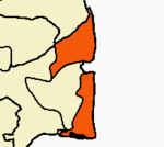
Country State Region Divisions Taluks Kilvelur · Kuthalam · Mayiladuthurai · Nagapattinam · Sirkazhi · Tharangambadi · Thirukkuvalai · VedaranyamRevenue blocks Keelaiyur · Kilvelur · Kollidam · Kuthalam · Mayiladuthurai · Nagapattinam · Sembanar Koil · Sirkazhi · Talanayar · Thirumarugal · VedaranyamMunicipalities Rivers History Early Cholas · Kalabhras · Pallavas · Medieval Cholas · Later Cholas · Later Pandyas · Delhi Sultanate · Madurai Sultanate · Vijayanagar Empire · Thanjavur Nayaks · Thanjavur Marathas · Company Raj · British RajPlaces of interest Chudamani Vihara · Ganapathi Temple, Thiruchengattankudi · Kayarohanaswami Temple, Nagapattinam · Kazheesirama Vinnagaram · Mayuranathaswami Temple, Mayiladuthurai · Nagannathaswamy Temple, Keezhaperumpallam · Nangur Vishnu Temples · Point Calimere Wildlife and Bird Sanctuary · Puhar · Punjai Siva Temple · Sattainathar Temple, Sirkazhi · Sayavaneswarar Temple · Sembanarkoil · Sikkal Singaravelan Temple · Sri Sivalokanathar Temple, Tirupunkur · Swetharanyeswarar Temple · Tharangambadi · Therazhundur · Thirukkadaiyur · Thiruvenkadu · Vaitheeswaran Koil · Valampurinathar Temple · Vanjinatha Temple · Vedaranyeswarar Temple · Viratteswara Temple, VazhuvurReligious and monastic institutions Dharmapuram Adheenam · Thiruvaduthurai AdheenamCities and towns · People · Villages Categories:


Wikimedia Foundation. 2010.