- Geography of Botswana
-
Geography of Botswana 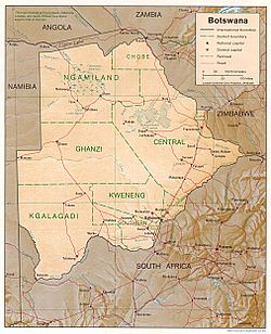
Continent Africa Region Southern Africa Coordinates 22°00′S 24°00′E / 22°S 24°E Area Ranked 48th
581,730 km2 (224,610 sq mi)
97.42% land
2.58% waterBorders Total land borders: 4,013 km (2,494 mi)
Namibia: 1,360 km (850 mi)
South Africa: 1,840 km (1,140 mi)
Zimbabwe: 813 km (505 mi)Highest point Tsodilo Hills 1,489 m (4,885 ft) Lowest point Junction of the Limpopo and Shashe Rivers 513 m (1,683 ft)  Satellite image of Botswana
 Elevation map of Botswana
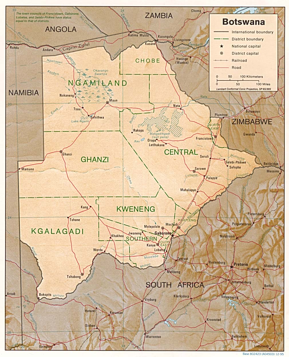
Botswana is a landlocked country located in Southern Africa, north of South Africa. Botswana occupies an area of 600,370 square kilometres, of which 585,000 km² are land. Botswana has land boundaries of combined length 4,013 kilometres, of which the constituent boundaries are shared with Namibia, for 1,360 km; South Africa 1,840 km; Zimbabwe, 813 km and Zambia, less than 1 km. Much of the population of Botswana is concentrated in the eastern part of the country.
|1}}. Sunshine totals are high all year round although winter is the sunniest period. The whole country is windy and dusty during the dry season.[1]
Contents
Orography
The land is predominantly flat to gently undulating tableland, although there is some hilly country, where mining is carried out. The Kalahari Desert is in the central and the southwest. The Okavango Delta, the world's largest inland delta, is in the northwest and the Makgadikgadi Pans, a large salt pan lies in the north-central area. The Makgadikgadi has been established as an early habitation area for primitive man; This large seasonal wetland is composed of several large component pans, the largest being Nwetwe Pan, Sua Pan and Nxai Pan.[2] Botswana's lowest elevation point is at the junction of the Limpopo and Shashe Rivers, at a height of 513 m. The highest point is Monalanong Hill, at 1,494 m. The country is divided into four drainage regions, which are sometimes indistinct due to the arid nature of the climate:
- the Chobe River on the border with the Caprivi Strip of Namibia together with a small adjacent swampy area is part of the Zambezi basin;
- most of the north and central region of the country is part of the Okavango inland drainage basin;
- the easternmost part of the country falls into the Limpopo drainage basin;
- the southern and southwestern regions, which are the driest of all, are drained by the Molopo river along the South African border and the Nossob river through the Kalahari Gemsbok National Park, and are technically part of the basin of the Orange river. None of these rivers normally flows as far as the Orange, however. (The last recorded confluence was in the 1880s.)[3]
Except for the Chobe, Okavango, Boteti and Limpopo rivers, most of Botswana's rivers cease to flow during the dry and early rainy seasons.
Natural hazards
Botswana is affected by periodic droughts, and seasonal August winds blow from the west, carrying sand and dust, which can obscure visibility.
Environment
Current environmental issues in Botswana are overgrazing, desertification and the existence of only limited fresh water resources.
Research from the University of Botswana has found that the common practice of overstocking cattle to cope with drought losses actually depletes scarce biomass, making ecosystems more vulnerable. The study of the Kgatleng district predicts that by 2050 the cycle of mild drought is likely to become shorter —18 months instead of two years—due to climate change.[4]
International agreements
Botswana is a party to the following international agreements: Diamond Industry, Biodiversity, Climate Change, Desertification, Endangered Species, Hazardous Wastes, Law of the Sea, Nuclear Test Ban, Ozone Layer Protection and Wetlands.
Extreme points
This is a list of the extreme points of Botswana, the points that are farther north, south, east or west than any other location.
- Northernmost point - the tripoint with Zambia and Namibia, Ngamiland District
- Easternmost point - the tripoint with South Africa and Zimbabwe, Central District
- Southernmost point - Bokspits, Kgalagadi District
- Westernmost point - the western section of the border with Namibia*
- Note: Botswana does not have a westernmost point as the western section is formed by the 22nd meridian of longitude east of Greenwich.
References
- ^ General Survey of Climatology, Landsberg (ed.),Elsevier, 2001
- ^ C. Michael Hogan (2008) Makgadikgadi, Megalithic Portal, ed. A.Burnham
- ^ Times Comprehensive Atlas, (2007), Times Books, London
- ^ Sub-Saharan Africa news in brief: 10–22 April 2008 - SciDev.Net
Sovereign
states- Algeria
- Angola
- Benin
- Botswana
- Burkina Faso
- Burundi
- Cameroon
- Cape Verde
- Central African Republic
- Chad
- Comoros
- Democratic Republic of the Congo
- Republic of the Congo
- Côte d'Ivoire (Ivory Coast)
- Djibouti
- Egypt
- Equatorial Guinea
- Eritrea
- Ethiopia
- Gabon
- The Gambia
- Ghana
- Guinea
- Guinea-Bissau
- Kenya
- Lesotho
- Liberia
- Libya
- Madagascar
- Malawi
- Mali
- Mauritania
- Mauritius
- Morocco
- Mozambique
- Namibia
- Niger
- Nigeria
- Rwanda
- São Tomé and Príncipe
- Senegal
- Seychelles
- Sierra Leone
- Somalia
- South Africa
- South Sudan
- Sudan
- Swaziland
- Tanzania
- Togo
- Tunisia
- Uganda
- Zambia
- Zimbabwe
States with limited
recognition- Sahrawi Arab Democratic Republic
- Somaliland
Dependencies and
other territories- Canary Islands / Ceuta / Melilla / Plazas de soberanía (Spain)
- Madeira (Portugal)
- Mayotte / Réunion (France)
- Saint Helena / Ascension Island / Tristan da Cunha (United Kingdom)
- Western Sahara
Climate of Africa Sovereign
states- Algeria
- Angola
- Benin
- Botswana
- Burkina Faso
- Burundi
- Cameroon
- Cape Verde
- Central African Republic
- Chad
- Comoros
- Democratic Republic of the Congo
- Republic of the Congo
- Côte d'Ivoire (Ivory Coast)
- Djibouti
- Egypt
- Equatorial Guinea
- Eritrea
- Ethiopia
- Gabon
- The Gambia
- Ghana
- Guinea
- Guinea-Bissau
- Kenya
- Lesotho
- Liberia
- Libya
- Madagascar
- Malawi
- Mali
- Mauritania
- Mauritius
- Morocco
- Mozambique
- Namibia
- Niger
- Nigeria
- Rwanda
- São Tomé and Príncipe
- Senegal
- Seychelles
- Sierra Leone
- Somalia
- South Africa
- South Sudan
- Sudan
- Swaziland
- Tanzania
- Togo
- Tunisia
- Uganda
- Zambia
- Zimbabwe
States with limited
recognition- Sahrawi Arab Democratic Republic
- Somaliland
Dependencies and
other territories- Canary Islands / Ceuta / Melilla / Plazas de soberanía (Spain)
- Madeira (Portugal)
- Mayotte / Réunion (France)
- Saint Helena / Ascension Island / Tristan da Cunha (United Kingdom)
- Western Sahara
Categories:


Wikimedia Foundation. 2010.