- Queen Charlotte Islands
Infobox Islands
name = Queen Charlotte Islands
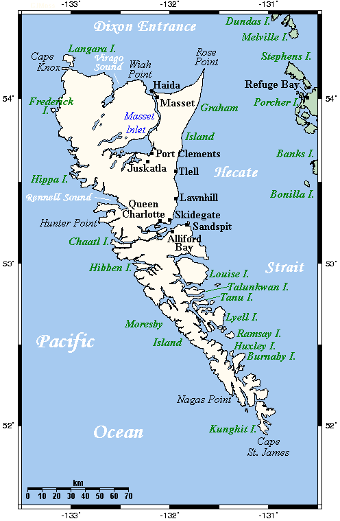
image caption =
image size =
locator
map_custom = no
native name = Haida Gwaii
native name link = Haida language
nickname =
location =Pacific Ocean
coordinates = coord|53|00|N|132|00|W|display=inline,title
archipelago =
total islands = ~150
major islands =Graham Island ,Moresby Island
area = convert|10180|km2|sqmi|abbr=on
highest mount =
elevation =
country = Canada
country admin divisions title = Province
country admin divisions = flag|British Columbia
country largest city = Masset
country largest city population = 941
population = 5000
population as of =
density =
ethnic groups =Haida
additional info =The Queen Charlotte Islands [BCGNIS|38615] or Haida Gwaii ("Islands of the People"), and originally in Haida, Xhaaidlagha Gwaayaai ("islands on the edge of the world"), are an
archipelago off the northwest coast ofBritish Columbia ,Canada , consisting of two main islands,Graham Island in the North, andMoresby Island in the south, and approximately 150 smaller islands with a total landmass of 10,180 km² (3,932 sq mi). Other major islands include Langara, Louise, Lyell, Burnaby, andKunghit Island The islands are separated from the British Columbia mainland to the east byHecate Strait .Vancouver Island lies to the south, across Queen Charlotte Sound, while the U.S. state ofAlaska is to the north, across theDixon Entrance .Some of the land, including the homelands of some of the
Haida peoples, is jointly protected under federal and Haida legislation asGwaii Haanas National Park Reserve and Haida Heritage Site . Theisland s are home to an abundance ofwildlife , including the largest subspecies of black bear ("Ursus americana carlottae") and the subspecies ofstoat "Mustela erminea haidarum". Theblack-tailed deer andraccoon are introduced species that have become abundant.Economy
The cash economy is blended, including art and natural resources, primarily
logging andcommercial fishing . Furthermore, service industries and government jobs provide about one-third of the jobs, andtourism has become a more prominent part of the economy in recent years, especially forfishing andtour guide s,cycling ,camping , andadventure tourism .Population
At the time of colonial contact, the population was roughly 10,000 to 60,000 peopleFact|date=May 2008, residing in several dozen towns and including slave populations drawn from other tribes. Ninety percent of the population died during the 1800s from
smallpox ; other diseases arrived as well, includingtyphoid ,measles , andsyphilis , affecting many more inhabitants. By 1900, only 350 people remained. Towns were abandoned as people left their homes for the towns of Skidegate and Masset, cannery towns on the mainland, or for Vancouver Island. Today, some 5000 people live on the islands. Indigenous people (Haida) live throughout the islands, and are concentrated around Skidegate and Old Masset, each with a population of about 1000. Anthony Island and the town ofNinstints were made aUNESCO World Heritage Site in 2006; in the decision, the decline in population wrought by disease was referenced when citing the 'vanished civilization' of the Haida. [ [http://whc.unesco.org/archive/advisory_body_evaluation/157.pdf UNESCO World Heritage Site: Justification, 1981] ]European exploration
The archipelago was visited in 1774 by Juan Pérez (at
Langara Island ) and in 1778 by CaptainJames Cook . In 1787 the islands were surveyed by Captain George Dixon. The islands were named by Captain Dixon after one of his ships, the "Queen Charlotte", which was named after Queen Charlotte, wife of KingGeorge III of the United Kingdom .The name Haida Gwaii is of modern coinage and was created as an alternative to the colonial name "Queen Charlotte Islands", to recognize the history of the Haida Nation. "Haida Gwaii" means "our land", while "Haida" on its own means not only "us" but also "people".
No longer in common usage is the more ancient and original name of 'Xaadala Gwayee' or, in alternative
orthography , 'Xhaaydla Gwaayaay', meaning Islands on the Xhaaydla, that is to say, Islands on the Boundary between Worlds, 'Worlds' referring here to the forest, sea, and sky; indeed, the coastal villages of the Haida occur along the meeting of forest, sea, and sky.Natural setting
The archipelago seems to have escaped much of the glaciation of the last
ice age . That, and its subsequent isolation from the mainland, has produced what some call the "Galápagos of the North," a unique biological zone with many endemic animals and plants. Its climate, like that of the rest of the British Columbia and Alaskan coast in the area, is moderated by theKuroshio Current , and features considerable precipitation and relatively mild temperatures throughout the year.The
Yakoun River , the largest on Graham Island, was the site ofKiidk'yaas (meaning "ancient tree"), the only naturally occurring goldenSitka Spruce in the world. The Golden Spruce was sacred to theHaida people, as well as a popular tourist attraction. The 500-year-old tree was illegally cut down byGrant Hadwin onJanuary 22 1997 , as an apparent political protest against Canadian-government-sanctioned logging companies. [ [http://209.85.135.104/search?q=cache:eG5K0dqsy8oJ:www.newyorker.com/fact/content/%3F021104fa_fact+golden+spruce&hl=de&ct=clnk&cd=4&gl=de] ]The islands are home to a wide variety of other large native trees, including the beautiful
Western Redcedar ,Yellow Cedar (Nootka Cypress ), Shore Pine,Western Hemlock ,Mountain Hemlock , andRed alder .Another rare natural occurrence that was popular amongst tourists to Haida Gwaii was the "White Raven". This was an
albino raven that was often mistaken for aneagle orseagull owing to its unusual colouring. The "White Raven" lived around Port Clements and would commonly be seen taking food handouts from locals and visitors alike. It died after making contact with an electrical transformer, temporarily knocking out power to the town and surrounding area.Earthquake hazards
The Queen Charlotte Islands are located along the
Queen Charlotte Fault , which is an activetransform fault that produces significant earthquakes every 3–30 years. The fault is the underwater meeting of the Pacific and North American Plates along the Queen Charlotte west coast. The largest recorded earthquake occurred in 1949, with a magnitude of 8.1 on theRichter Scale . The earthquake tipped cows, toppled chimneys, and an oil tank at Cumshewa Inlet collapsed. [Citation
last =
first =
author-link =
last2 =
first2 =
author2-link =
title = On This Day August 22, 1949
newspaper = National Post
pages = B14
year = 2008
date = Friday, August 22, 2008
url = ] The most recent earthquakes were in January 2008, measuring up to 6.5.Culture
Visual arts
The artwork known as "Haida Gwaii", by
Bill Reid , is featured on the reverse of the Canadian $20 bill. [http://www.bank-banque-canada.ca/en/banknotes/graphs/photos/general/2001-04/cjs_20b.gif] The piece depicts theSpirit of Haida Gwaii in a canoe, accompanied by the mythic messengers. Haida art is also frequently seen on large monumental sized cedartotem poles and dugout canoes, hand crafted gold and silver jewelry, and even as cartoons in the form ofHaida Manga .Haida language
The
Haida language has been classified as part of theNadene family of languages on the basis of a few similarities with Athabaskan-Eyak-Tlingit. Many linguists consider the evidence inconclusive and continue to regard Haida as anlanguage isolate . All 50 remaining speakers of Haida are over 70.Telus and the Gwaii Trust recently completed a project to bring broadband internet to the island via a 150 kilometre microwave relay. This enables interactive research to be carried out on the more than 80 CDs of language, story and spoken history of the people.Transportation
The main transportation links between the Islands and mainland
British Columbia are theBC Ferries terminal atSkidegate , theMasset Airport , and theSandspit Airport . The westernmost leg of Highway 16 connectsMasset and Skidegate on Graham Island, and Skidegate with Prince Rupert on the mainland via regular BC Ferries service by the MV "Queen of Prince Rupert" and MV "Northern Adventure". There is also regular BC Ferries service between Skidegate and Alliford Bay on Moresby Island. Floatplane services connect to facilities such as theAlliford Bay Water Aerodrome andMasset Water Aerodrome .See also
*
Colony of the Queen Charlotte Islands
*Queen Charlottes Gold Rush References
External links
* [http://www.hellobc.com/en-CA/SightsActivitiesEvents/QueenCharlotteCity.htm Hello BC - official tourism site]
* [http://www.qcinfo.ca Queen Charlotte Island Visitor Information Centre]
* [http://www.sandspitqci.com/ Sandspit Chamber Of Commerce]
* [http://www.massetbc.com/index.html Village of Masset]
* [http://portclements.com/ Village of Port Clements]
* [http://www.skidegate.ca/chn.html Council of the Haida Nation]
* [http://www.haidaheritagecentre.com/ Haida Heritage Centre at Kaay Llnagaay]
* [http://www.haidanation.ca Information on the forestry dispute]
* [http://www.qciobserver.com/ The QCI Observer - Local Newspaper]
Wikimedia Foundation. 2010.