- Chiltern Hills
-
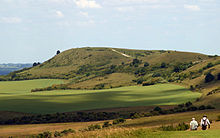
Chiltern Hills  Chiltern Hills near Nettlebed
Country England Counties Bedfordshire
Buckinghamshire
Hertfordshire
OxfordshireLocation South East England Highest point - location Haddington Hill - elevation 267 m (876 ft) Geology chalk downland Plant beech, bluebell, candytuft, woodruff Animal badger, muntjac, fallow deer, fox, kestrel, red kite, woodpecker Founded 1965 The Chiltern Hills form a chalk escarpment in South East England. They are known locally as "the Chilterns". A large portion of the hills was designated officially as an Area of Outstanding Natural Beauty in 1965.
Contents
Location
The Chilterns stretch in a 76 km (47 mi) southwest to northeast diagonal from Goring-on-Thames in Oxfordshire, through Buckinghamshire, via Dunstable Downs and Deacon Hill in Bedfordshire, to near Hitchin in Hertfordshire.[1]
The boundary of the hills is clearly defined on the northwest side by the scarp slope. The dip slope, by its nature, merges with the landscape to the southeast.[2] Similarly, the Thames provides a clear terminal to the southwest, whereas northeast of Luton the hills decline slowly in prominence.
Geology
The chalk escarpment of the Chiltern Hills overlooks the Vale of Aylesbury, and approximately coincides with the southernmost extent of the ice sheet during the last glacial maximum[citation needed]. The Chilterns are part of the Southern England Chalk Formation which also includes Salisbury Plain, Cranborne Chase, the Isle of Wight and the South Downs, in the south. In the north, the chalk formations continue northeastwards across north Hertfordshire, Norfolk and the Lincolnshire Wolds, finally ending as the Yorkshire Wolds in a prominent escarpment, south of the Vale of Pickering. The Southern England Chalk Formation was deposited over the buried northwestern margin of the Anglo-Brabant Massif during the Upper Cretaceous.[3] During this time, sources for siliciclastic sediment had been eliminated due to the exceptionally high sea level.[4] The formation is thinner though the Chiltern Hills than the chalk strata to the north and south and deposition was tectonically controlled, with the Lilley Bottom structure playing a significant role at times.[3] The Southern England Chalk Formation, like the underlying Gault Clay and Upper Greensand, is diachronous.[4]
During the late stages of the Alpine Orogeny, as the African Plate collided with Eurasian Plate, Mesozoic extensional structures, such as the Weald Basin of southern England underwent structural inversion.[3] This phase of deformation tilted the chalk strata to the southeast in the area of the Chiltern Hills. The gently dipping beds of rock were eroded, forming an escarpment.
Peak altitude is reached at 275 metres above sea level.[5]
The chalk strata are frequently interspersed with layers of flint nodules which apparently replaced chalk and infilled pore spaces early in the diagenetic history. Flint has been mined for millennia from the Chiltern Hills[citation needed]. They were first extracted for fabrication into flint axes in the Neolithic period, then for knapping into flintlocks. Nodules are to be seen everywhere in the older houses as a construction material for walls.
Physical characteristics
 Ivinghoe Beacon (the eastern trailhead) seen looking north from The Ridgeway
Their highest point is 267 m (876 ft) at Haddington Hill near Wendover in Buckinghamshire; a stone monument marks the summit. The nearby Ivinghoe Beacon is a more prominent hill, although it only stands 249 m (817 ft) above sea level. It is the starting point of the Icknield Way Path and the Ridgeway long distance path, which follows the line of the Chilterns for many miles to the west, where they merge with the Wiltshire downs and southern Cotswolds. To the east of Ivinghoe Beacon is Dunstable Downs, a steep section of the Chiltern scarp that is the site of the famous London Gliding Club and Whipsnade Zoo. Near Wendover is Coombe Hill which is 260 m (853 ft) above sea level.
The more gently sloping country – the dip slope – to the southeast of the Chiltern scarp is also generally referred to as the Chilterns, containing much beech woodland and many villages.
Rivers that drain from the Chiltern Hills include the River Mimram, River Lea, River Ver, River Gade, River Bulbourne, River Chess, River Misbourne and River Wye. These are classified as chalk streams, although the River Lea is degraded by water from road drains and sewage treatment works.[6]
The opening credits of the BBC sitcom The Vicar of Dibley feature an aerial shot of the Stokenchurch Gap. This is a major excavation which eases the M40 motorway from the Chilterns into the Vale of Oxford. It is between junctions 5 and 6. The chalk that forms the hills can clearly be seen on both sides of the cutting when driving on the motorway.
History
In pre-Roman times, the Chiltern ridge provided a relatively safe and easily negotiable route across southern Iron Age England, thus the Icknield Way (one of England's ancient prehistoric trackways) follows the line of the hills. Its name comes from that of the Cilternsæte, a tribe that occupied the area in early Anglo-Saxon period.
One of the principal Roman settlements in the Roman province of Britannia Superior was sited at Verulamium (now St Albans) and there are significant Roman and Romano-British remains in the area.
The Tudors had a hunting lodge in the Hemel Hempstead area.
Settlement
Until the coming of the railways and, later, the motor-car, the Chilterns were largely rural with country towns situated on the main routes through the hills. The position of the hills, northwest of London, has affected the routing of major road, rail and canal routes. These were funnelled through convenient valleys (e.g., High Wycombe, Hemel Hempstead) and encouraged settlement and, later, commuter housing.
The western edge of the Chilterns is notable for its ancient strip parishes, elongated parishes with villages in the flatter land below the escarpment and woodland and summer pastures in the higher land.[7]
List of towns and villages within the overall Chilterns Hills area
 Watlington Town Hall from the south
- Aldbury, Amersham, Apsley, Ashridge
- Barton-le-Clay, Beaconsfield, Bellingdon, Berkhamsted, Bledlow Ridge, Bovingdon, Bradenham, Breachwood Green, Buckland Common
- Caddington, Chalfont St Giles, Chalfont St Peter, Chartridge, Chesham, Chinnor, Chiltern Green, Christmas Common, Cholesbury
- Dunsmore, Dunstable
- Edlesborough, Ellesborough
- Fawley, Fingest, Flackwell Heath, Frieth
- Gerrards Cross, Goring-On-Thames, Great Kingshill, Great Missenden, Great Hampden, Great Offley
- Halton, Hambleden, Hawridge, Hemel Hempstead, Henley-on-Thames, Hexton, High Wycombe, Hitchin, Hughenden
- Ibstone
- Jordans
- Kensworth
- Lane End, Ley Hill, Little Chalfont, Little Kingshill, Little Missenden, Little Gaddesden, Lilley, Luton
- Markyate, Marlow, Medmenham
- Naphill, Nettlebed, Nuffield, Oxfordshire
- Pishill, Princes Risborough, Prestwood, Redbourn
- Skirmett, Sharpenhoe, Shiplake, Southend, Speen, St Leonards, Stokenchurch, Stonor, Streatley (Beds).Studham
- Thame, Tring, Turville
- Walter's Ash, Watlington, Wendover, West Wycombe, Whitwell, Whipsnade, Wigginton, Woodcote
Strip parishes partly in the Chilterns
- Bedfordshire: Eaton Bray, Toddington, Totternhoe
- Buckinghamshire: Aston Clinton, Bledlow, Buckland, Drayton Beauchamp, Great Kimble, Horsenden, The Lee, Marsworth, Monks Risborough, Pitstone, Princes Risborough, Saunderton, Stoke Mandeville, Weston Turville
- Hertfordshire: Tring, Wigginton
- Oxfordshire: Aston Rowant, Checkendon, Chinnor, Ipsden, Lewknor, Mongewell, Newnham Murren, Nuffield, Pyrton, Shirburn, South Stoke, Watlington
Use
The hills have been exploited for their natural resources for millennia. The chalk has been quarried for the manufacture of cement, and flint for local building material. Beechwoods supplied furniture makers with quality hardwood. The area was once (and still is to a lesser degree) renowned for its chair-making industry, centred on the towns of Chesham and High Wycombe (the nickname of Wycombe Wanderers Football Club is the Chairboys). The clean water from the aquifer is still used for public supply and the rivers and streams have fed watercress beds. The chalk of the hills is an important aquifer, exploited to provide water supplies in the area; it has been suggested that over-exploitation has led to the disappearance of some streams.
In a region short of building stone, local clay deposits and timber provided the raw materials for brick manufacture. Where available, flint was also used for construction; it is still used in modern buildings, although restricted to decoration to give a vernacular appearance.
Mediaeval strip parishes reflected the diversity of land from clay farmland, through wooded slopes to downland. Their boundaries were often drawn to include a section of each type of land, resulting in an irregular county boundary between, say, Bedfordshire and Hertfordshire. These have tended to be smoothed out by successive reorganisations.
In modern times, as people have come to appreciate open country, the area has become a visitor destination and the National Trust has acquired land to preserve its character, for example at Ashridge, near Tring. In places, with the reduction of sheep grazing, action has been taken to maintain open downland by suppressing the natural growth of scrub and birch woodland. In the 1920s and 1930s, the Youth Hostels Association established several youth hostels for people visiting the hills.
The hills have been used as a location for telecommunication relay stations such as Stokenchurch BT Tower and that at Zouches Farm.
Protection
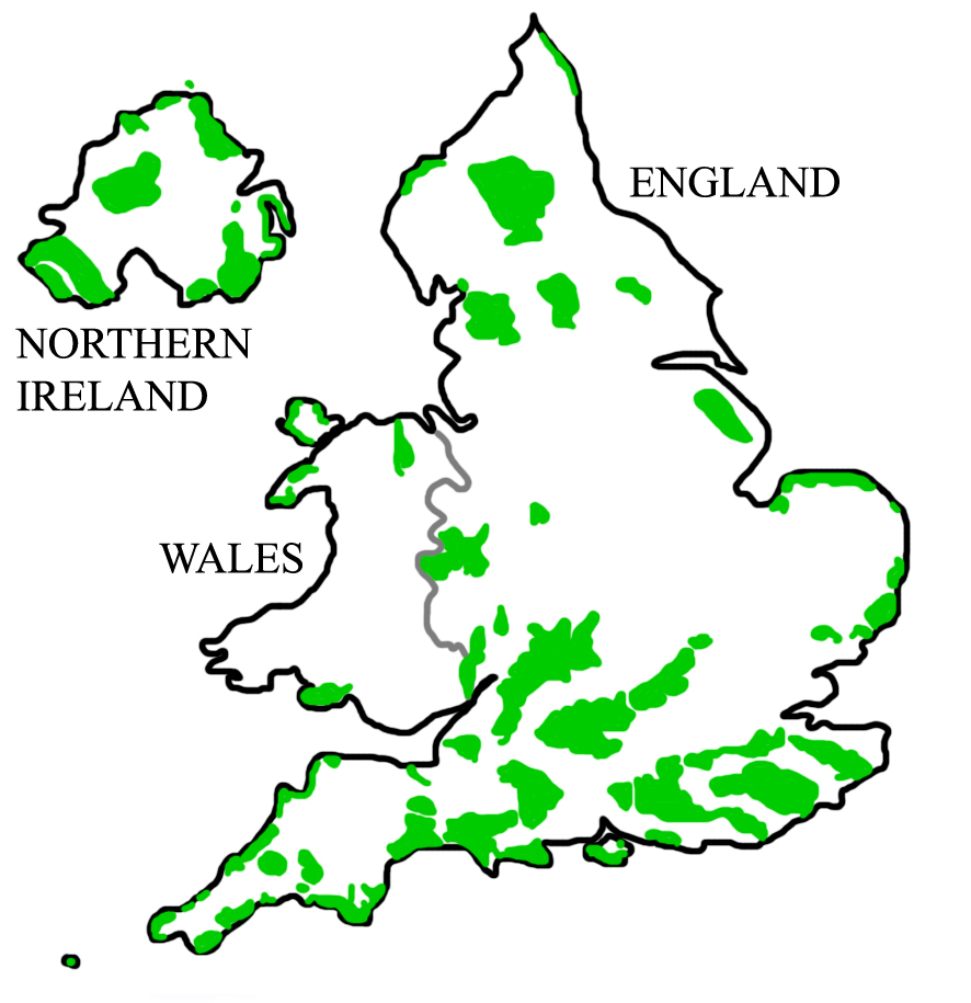
The Chilterns is an Area of Outstanding Natural Beauty and so enjoys special protection from major developments, which should not take place in such areas except in exceptional circumstances. This protection applies to major development proposals that raise issues of national significance.[8] In 2000 the government confirmed that the landscape qualities of AONBs are equivalent to those of National Parks, and that the protection given to both types of area by the land use planning system should also be equivalent. In October 2010 the government confirmed proposals for the High Speed 2 rail link from London to Birmingham with a recommended route through the Chilterns AONB.
Administration
In contrast to National Parks, the Chilterns - as other AONBs - do not possess their own planning authority. The Chilterns Conservation Board has an advisory role on planning and development matters and seeks to influence the actions of local government by commenting upon planning applications.[9]
The local authorities (four County Councils, one Unitary Authority and ten District and Borough Councils) are expected to respect the area's status as a designated Area of Outstanding Natural Beauty.
Chiltern Hundreds
The Chilterns includes the Chiltern Hundreds. By established custom, Members of the British Parliament, who are prohibited from resigning their seats directly, may apply for the Stewardship of the Chiltern Hundreds as a device to enable their departure from the House (see Resignation from the House of Commons).
See also
References
- ^ Chiltern Society, The Chilterns.
- ^ L. W. Hepple and A. M. Doggett, The Chilterns, 2nd ed, Phillimore, 1994, ISBN 0-85033-833-6, page 7.
- ^ a b c Rawson, P.F. 2006. Cretaceous: sea levels peak as the North Atlantic opens. In: P.J. Brenchley and P.F. Rawson (Eds) The Geology of England and Wales, p.365-393. The Geological Society ISBN 9781862392007
- ^ a b Anderson, R., P.H. Bridges, M.R. Leeder and B.W. Sellwood (Eds) 1979. A Dynamic Stratigraphy of the British Isles: A Study in Crustal Evolution. p. 241. George Allen and Unwin, London. ISBN 0412445107
- ^ Natural England
- ^ B.S. Nau, C. R. Boon, and J. P. Knowles, Bedfordshire Wildlife, Castlemead, 1987, ISBN 0-948555-05-X, page 71.
- ^ Hepple, Leslie; Doggett, Alison (1971). The Chilterns. England: Phillimore & Co Ltd. ISBN 0 85033 833 6.
- ^ Planning Policy Statement 7: Sustainable Development in Rural Areas
- ^ Chilterns Conservation Board
External links
East of England 
East Midlands North East North West South East Chichester Harbour | Chilterns | East Hampshire | High Weald | Isle of Wight | Kent Downs | South Hampshire Coast | Surrey Hills | South DownsSouth West West Midlands Yorkshire and Humber Categories:- Chiltern Hills
- Areas of Outstanding Natural Beauty in England
- Geology of England
- Hills of Bedfordshire
- Hills of Buckinghamshire
- Hills of Hertfordshire
- Hills of Oxfordshire
- Protected areas of Bedfordshire
- Protected areas of Buckinghamshire
- Protected areas of Oxfordshire
- Protected areas of Hertfordshire


Wikimedia Foundation. 2010.