- National Register of Historic Places listings in Clarke County, Alabama
-
 Location of Clarke County in Alabama
This is a list of the National Register of Historic Places listings in Clarke County, Alabama.
This is intended to be a complete list of the properties and districts on the National Register of Historic Places in Clarke County, Alabama, United States. Latitude and longitude coordinates are provided for many National Register properties and districts; these locations may be seen together in a Google map.[1]
There are 21 properties and districts listed on the National Register in the county.
-
- This National Park Service list is complete through NPS recent listings posted November 10, 2011.[2]
Current listings
[3] Landmark name Image Date listed Location City or town Summary 1 Airmount Grave Shelter 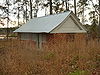
February 24, 2000 Northern side of State Route 5, 0.5 miles west of the county line
31°58′08″N 87°40′09″W / 31.968889°N 87.669167°WThomasville 2 Alston-Cobb House 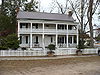
April 30, 1979 120 Cobb St.
31°42′33″N 87°47′34″W / 31.709167°N 87.792778°WGrove Hill 3 Bush House 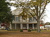
July 28, 1999 168 N. Church St.
31°42′57″N 87°46′32″W / 31.715833°N 87.775556°WGrove Hill 4 Clarke Mills 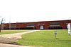
April 30, 1998 301 W. Church St.
31°30′33″N 87°53′50″W / 31.509167°N 87.897222°WJackson 5 Stephen Beech Cleveland House 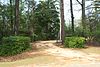
July 28, 1999 County Road 35, 2.4 miles south of U.S. Route 84
31°36′36″N 87°41′16″W / 31.61°N 87.687778°WSuggsville 6 John A. Coate House 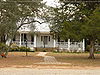
July 28, 1999 DuBose St., between Church and Crawford Sts.
31°42′17″N 87°46′29″W / 31.704722°N 87.774722°WGrove Hill 7 Cobb House 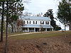
July 28, 1999 U.S. Route 84, 1.4 miles west of U.S. Route 43
31°42′28″N 87°48′07″W / 31.707778°N 87.801944°WGrove Hill 8 Dickinson House 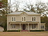
September 13, 1978 101 Dickinson Ave.
31°42′36″N 87°46′21″W / 31.71°N 87.7725°WGrove Hill 9 Fort Sinquefield 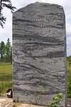
December 31, 1974 Southeast of Grove Hill
31°09′34″N 87°42′22″W / 31.159444°N 87.706111°WGrove Hill 10 Gainestown Methodist Church and Cemetery 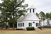
July 28, 1999 County Road 29, 0.3 miles south of County Road 33
31°26′31″N 87°41′40″W / 31.441944°N 87.694444°WGainestown 11 Gainestown Schoolhouse 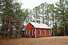
October 1, 1992 Western side of Gainestown-Suggsville Public Rd. north of Good Hope Church
31°27′10″N 87°41′33″W / 31.452778°N 87.6925°WGainestown 12 Grove Hill Courthouse Square Historic District 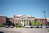
April 30, 1998 Roughly along Cobb, Court, Jackson, and Main Sts. Grove Hill 13 Jackson Historic District 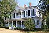
January 23, 1998 Roughly along College, Forest, and Carroll Aves., bounded by Cedar, Florida, Commerce, Clinton, and Spruce Sts. Jackson 14 Doit W. McClellan Lustron House 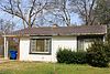
February 24, 2000 116 W. Pearl St.
31°30′59″N 87°53′45″W / 31.516389°N 87.895833°WJackson 15 J. P. McKee Lustron House 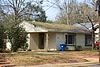
February 24, 2000 519 College Ave.
31°31′00″N 87°53′43″W / 31.516667°N 87.895278°WJackson 16 Isaac Nettles Gravestones 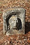
February 24, 2000 Eastern side of Mt. Nebo Rd., 0.5 miles south of County Road 19
31°20′47″N 87°52′05″W / 31.346389°N 87.868056°WCarlton 17 Jesse Pickens Pugh Farmstead 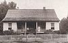
July 28, 1999 U.S. Route 84, 3.5 miles west of Grove Hill
31°42′21″N 87°49′58″W / 31.705833°N 87.832778°WGrove Hill 18 Thomasville Historic District 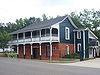
February 12, 1999 Roughly bounded by State Route 43, 1145 W. Front St., Wilson St., and 818 W. 3rd St. Thomasville 19 Whatley Historic District 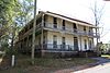
April 30, 1998 Roughly along Whatley Rd. from Grove Hill to the railroad tracks Whatley 20 Wilson-Finlay House 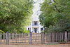
July 12, 1978 North of Gainestown on Suggsville Rd.
31°27′12″N 87°41′29″W / 31.453333°N 87.691389°WGainestown 21 Woodlands 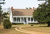
April 28, 1980 Off U.S. Route 84
31°35′03″N 87°34′24″W / 31.584167°N 87.573333°WGosport See also
- List of National Historic Landmarks in Alabama
- National Register of Historic Places listings in Alabama
References
- ^ The latitude and longitude information provided in this table was derived originally from the National Register Information System, which has been found to be fairly accurate for about 99% of listings. For about 1% of NRIS original coordinates, experience has shown that one or both coordinates are typos or otherwise extremely far off; some corrections may have been made. A more subtle problem causes many locations to be off by up to 150 yards, depending on location in the country: most NRIS coordinates were derived from tracing out latitude and longitudes off of USGS topographical quadrant maps created under North American Datum of 1927, which differs from the current, highly accurate GPS system used by Google maps. Chicago is about right, but NRIS longitudes in Washington are higher by about 4.5 seconds, and are lower by about 2.0 seconds in Maine. Latitudes differ by about 1.0 second in Florida. Some locations in this table may have been corrected to current GPS standards.
- ^ "National Register of Historic Places: Weekly List Actions". National Park Service, United States Department of the Interior. Retrieved on November 10, 2011.
- ^ Numbers represent an ordering by significant words. Various colorings, defined here, differentiate National Historic Landmark sites and National Register of Historic Places Districts from other NRHP buildings, structures, sites or objects.
U.S. National Register of Historic Places in Alabama Lists by county Autauga • Baldwin • Barbour • Bibb • Blount • Bullock • Butler • Calhoun • Chambers • Cherokee • Chilton • Choctaw • Clarke • Clay • Cleburne • Coffee • Colbert • Conecuh • Coosa • Covington • Crenshaw • Cullman • Dale • Dallas • DeKalb • Elmore • Escambia • Etowah • Fayette • Franklin • Geneva • Greene • Hale • Henry • Houston • Jackson • Jefferson • Lamar • Lauderdale • Lawrence • Lee • Limestone • Lowndes • Macon • Madison • Marengo • Marion • Marshall • Mobile • Monroe • Montgomery • Morgan • Perry • Pickens • Pike • Randolph • Russell • St. Clair • Shelby • Sumter • Talladega • Tallapoosa • Tuscaloosa • Walker • Washington • Wilcox • Winston

Lists by city Other lists National Register of Historic Places in Clarke County, Alabama Historic districts Grove Hill Courthouse Square Historic District | Jackson Historic District | Thomasville Historic District | Whatley Historic District

Other properties Airmount Grave Shelter | Alston-Cobb House | Bush House | Clarke Mills | Stephen Beech Cleveland House | John A. Coate House | Cobb House | Dickinson House | Fort Sinquefield | Gainestown Methodist Church and Cemetery | Gainestown Schoolhouse | Doit W. McClellan Lustron House | J. P. McKee Lustron House | Isaac Nettles Gravestones | Jesse Pickens Pugh Farmstead | Wilson-Finlay House | Woodlands
See also: National Register of Historic Places listings in Clarke County, Alabama and List of National Historic Landmarks in AlabamaMunicipalities and communities of Clarke County, Alabama Cities 
Towns CDP Unincorporated
communitiesGhost towns Categories:- National Register of Historic Places in Clarke County, Alabama
-


Wikimedia Foundation. 2010.