- Samar
-
This article is about the province. For other uses, see Samar (disambiguation).
Samar — Province — 
SealMap of the Philippines with Samar highlighted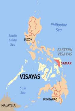
Coordinates: 11°50′N 125°00′E / 11.833°N 125°ECoordinates: 11°50′N 125°00′E / 11.833°N 125°E Country  Philippines
Region Eastern Visayas (Region VIII) Founded 1543, separated from Leyte in 1768;
became Western Samar on June 19, 1965;
renamed Samar in 1969Capital Catbalogan City Government – Type Province of the Philippines – Governor Sharee Ann T. Tan (NUP) – Vice-Governor Stephen James T. Tan (NUP) – 2nd District Representative Milagrosa T. Tan (NPC) – 1st District Representative Mel Senen S. Sarmiento (Liberal) Area – Total 6,048.0 km2 (2,335.1 sq mi) Area rank 12th out of 80 Population (2007) – Total 695,149 – Rank 37th out of 80 – Density 114.9/km2 (297.7/sq mi) – Density rank 62nd out of 80 Divisions – Independent cities 0 – Component cities 2 – Municipalities 24 – Barangays 951 – Districts 1st and 2nd districts of Samar Time zone PHT (UTC+8) ZIP Code Spoken languages Waray-Waray, Cebuano Samar, formerly and also known as Western Samar, is a province in the Philippines located in the Eastern Visayas region. Its capital is Catbalogan City and covers the western portion of Samar as well as several islands in the Samar Sea located to the west of the mainland. Catbalogan City and Calbayog City, two of the three cities on Samar Island, are located in the province of Samar. The province is bordered by Northern Samar and Eastern Samar. Samar is connected to island and province of Leyte via the San Juanico Bridge, which spans the San Juanico Strait, the narrowest strait in the country. To the south is the Leyte Gulf.
Contents
Languages/Dialect
Residents of Samar are mostly Waray, the sixth largest cultural-linguistic group in the country. 90.2% of the household population speaks the Waray language with 9.8 percent speaks Cebuano (8.1%), Boholano (0.07%), Tagalog (0.5%) and other languages. English and Chinese languages are also spoken.
Climate and Rainfall
Samar province falls under the 2nd and the 4th type of climate[clarification needed]. The 2nd type is characterized by having no dry season with a very pronounced maximum rain period which usually occur in December to January. Areas characterized by this climate are generally along or very near the eastern coast, thus are open to the northeast monsoon. Municipalities in the southeastern part of the province experience this type of climate.
For the 4th type of climate, rainfall is more or less evenly distributed throughout the year. This is an intermediate between the 1st and 2nd types, although it resembles the 2nd type more closely since it has no dry season. Those areas located in the northwestern part of the province has this type of climate.
Economy
Primarily, fishing and agriculture are the major economic activities of the province. Economical Data
Geography
Samar island occupies the eastern portion of the Philippines.. It lies southeast of Luzon and occupies the northernmost section of Eastern Visayas. It is separated from Luzon on the north by San Bernardino Strait and from Leyte on the southwest by the narrow San Juanico Strait. It is bounded on the east by the Pacific Ocean, on the south by Leyte Gulf and on the west by the Samar Sea.
Topography
Samar province is hilly, has some mountain peaks ranging from 200 to 800 meters high and narrow strips of lowlands, which tend to lie in coastal peripheries or in the alluvial plains and deltas accompanying large rivers. The largest lowlands are located along the northern coast extending up to the valleys of Catubig and Catarman rivers. Smaller lowlands in Samar are to be found in the Calbayog area and on the deltas and small valleys of Gandara and Ulot rivers. Slopes are generally steep and bare of trees due to deforestation. Run-off waters after heavy rains can provoke flooding in low-lying areas and the erosion of the mountains enlarges the coastal plains of the province.
Governance
The province of Samar is composed of two (3) congressional districts, twenty four (24) municipalities and two (3) cities (Catbalogan and Calbayog). It has a total of nine hundred fifty two (952) barangays
Cities
Municipalities
History
The explorer Ruy López de Villalobos, first came to the island in 1543 and named it +Las Islas Filipinas.
- 1596: Many names (Samal, Ibabao, Tandaya) were given to Samar Island prior to the coming of the Spaniards in 1596. The name Samar was derived from the local dialect “samad”, meaning wound or cut, which aptly describes the rough physical features of the island that is rugged and deeply dissected by streams. During the early days of Spanish occupation, Samar was under the jurisdiction of Cebu.
- 1735: Samar and Leyte were united into one province with Carigara, with Leyte as the capital town.
- 1768: Again Samar became a separate province in 1768.
- 1901: The Balangiga massacre occurs during the Philippine–American War.
- 1941: The invasion by the Japanese fighter and bomber planes was attacked in the province of Samar.
- 1941 to 1942: During the Japanese invasion during Second World War, when Filipino troops of the 91st Infantry Division, Philippine Commonwealth Army, USAFFE under the Visayan-Mindanao Force was established and general headquarters in Samar and started the fall to invasion of Samar and fought against the Japanese forces. This resulted in the defeat of the Filipino troops of the USAFFE 91st Division.
- 1942: The occupation of the Imperial Japanese forces arrives in the province of Samar.
- 1942 to 1944: During the Japanese Occupation, many of the several hundreds of thousands of local Samareño men and women was joining the recognized guerrilla groups in Samar and helping the local Filipino troops of the Philippine Commonwealth Army units against the Japanese Imperial forces and started the pre-Allied Liberation.
- 1942 to 1944: During the Japanese Occupation, The 4th, 9th, 93rd, 95th and 96th Infantry Division of the Philippine Commonwealth Army was re-established from 1942 to 1946 at the military general headquarters and military camps and garrisoned in the province of Samar was the military unit organization and started by the Anti-Japanese military operations in the province of Samar on 1942 to 1945 and fought against the Japanese Imperial forces.
- 1942 to 1944: The 96th Infantry Division of the Philippine Commonwealth Army was founded and establishment on 1942 to 1946 at the military general headquarters in the province of Samar in Eastern Visayas. The engagements of the Anti-Japanese military operations in the province of Samar on 1942 to 1945 and fought against the Japanese Imperial forces.
- 1942 to 1944: During the Japanese Insurgencies and Occupation, the Philippine Guerrilla Forces or PGF were established from 1942 to 1945 as a guerrilla resistance headquarters in San Andres in Villareal, Samar was the guerrilla unit organization and started by the anti-Japanese military operations in the province of Samar on 1942 to 1945 to helping the Filipino troops under the 4th, 9th, 93rd, 95th and 96th Infantry Divisions of the Philippine Commonwealth Army and fought against the Japanese Imperial forces.
- 1944: The Battle off Samar took place on October 24, 1944 as Vice Admiral Takeo Kurita's Center Force warships clashed with several allied naval vessels in a collision course. His force sinks escort carrier USS Gambier Bay (CVE-73), destroyers USS Hoel (DD-533) and USS Johnston (DD-557), and escort destroyer USS Samuel B. Roberts (DE-413), but at a cost of his cruisers Chikuma, Chokai, and Suzuya, which despite a tactical victory for the Imperial Japanese Navy, does not alter the course of the entire Philippines Campaign.
- 1944 to 1945: Combined U.S. and Philippine Commonwealth military forces including recognized guerrillas liberated the province of Samar and defeated Imperial Japanese forces. When the local Filipino soldiers under the USAFFE 91st and the 4th, 9th, 93rd, 95th and 96th Infantry Divisions of the Philippine Commonwealth Army and 9th Infantry Regiment of the Philippine Constabulary started the battles in Samar and fought against the Japanese troops.
- 1945: Filipino and Filipino-American soldiers under the 1st Filipino Infantry Regiment of the United States Army was beginning and started during the Battle of Samar and aided the local Filipino soldiers of the Philippine Commonwealth Army 4th, 9th, 91st, 93rd, 95th and 96th Infantry Division and the Philippine Constabulary 9th Infantry Regiment, the local Samareño guerrilla resistance and the U.S. liberation military forces defeats and attacking the Japanese liberated the province of Samar.
- 1965: On June 19, 1965 the Philippine Congress along with the District's Congressman, Felipe Abrigo, approved Republic Act No. 4221 dividing the region of Samar into three divisions: North Samar, East Samar, West Samar. Each region adopted a new capital: Catbalongan (West Samar), Borongan (East Samar), and Catarman (North Samar).
- 1969: On June 21, 1969, under Republic Act No. 5650, Western Samar was renamed Samar with Catbalogan still as the capital.
External links
- Official Website of the City Government of Calbayog
- Official Website of the City Government of Catbalogan
- Samar News.com—based in Catbalogan, it is a source of news and information on Eastern Visayas.
- Province of Samar—Profile of the Samar province
Municipalities Component cities - Catbalogan
- Calbayog
Categories:


Wikimedia Foundation. 2010.