- Currituck Beach Light
-
Currituck Beach Light 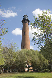
Currituck Beach Lighthouse Location Corolla, North Carolina Coordinates 36°22′36″N 75°49′51″W / 36.376667°N 75.830833°WCoordinates: 36°22′36″N 75°49′51″W / 36.376667°N 75.830833°W Year first lit 1875 Automated 1939 Construction brick Tower shape Conical tower Height 158 ft (48 m) Original lens First-order Fresnel lens Characteristic 20-second flash cycle (on for 3 seconds, off for 17 seconds) Admiralty number J2384 ARLHS number USA-212 USCG number 2-0555 Currituck Beach Lighthouse / Currituck Beach Lighthouse ComplexNRHP Reference#: 73001333 (original)
99000911[1] (increase)Significant dates Added to NRHP: October 15, 1973 Designated HD: January 12, 2000 The Currituck Beach Light is a lighthouse located on the Outer Banks in Corolla, North Carolina. An example of Gothic Revival architecture, the Currituck Beach Light was added to the National Register of Historic Places on October 15, 1973.[1]
Contents
History
On December 1, 1875, the Currituck Beach Light was completed, located between Cape Henry Light and Bodie Island. Unlike its fellows, Currituck Beach Light was not painted, leaving its brick facade visible. In 1939, the lighthouse was automated following a merger of the United States Coast Guard with the Bureau of Lighthouses.[2]
The Outer Banks Conservationists (OBC) performed much of the reconstruction and refurbishing work since 1980 through private funding and volunteer work. Since 1991 visitors have been allowed to climb the original 214 steps to the outdoor gallery. Access to the lens room is not permitted as the first order lens is not only the original lens, but it is still a functioning one. The light comes on every night and shines from 158 feet (48 m) at 20-second intervals to warn ships hugging the chain of barrier islands along the coast.
In 2003 the Federal Government granted OBC the title to the lighthouse itself. The Coast Guard approved OBC’s ownership proposal over that of an application submitted by Currituck County (the county in which the lighthouse is located). Through state and federal legislative maneuvering, the county sued OBC to try to acquire the property. The case was finally settled in 2006. OBC remains the owner of the Currituck Beach Lighthouse.
Facts
- Number of steps: 214
- Height to focal plane of lens: 158 feet (48.2 m)
- Height to top of roof: 162 feet (49.4 m)
- Number of bricks: approximately one million
- Thickness of wall at base: 5 feet 8 inches (1.7 m)
- Thickness of wall at parapet: 3 feet (0.9 m)
- Position: 34 miles (54.7 km) south of the Cape Henry (Virginia) Lighthouse; 32½ miles (52.3 km) north-northwest of Bodie Island Lighthouse
- Coast Survey Chart: 36° 22'36" N latitude, 75° 49'51" W longitude.
 Currituck Beach Light, ca. 1883
As it had reported in previous years, the U.S. Light-House Board in 1872 stated that ships, cargoes, and lives continued to be lost along the 40 miles (64 km) of dark coastline that lay beyond the reaches of existing lighthouses. Southbound ships sailing closer to shore to avoid the Gulf Stream were especially in danger. In response, construction began on the Currituck Beach Lighthouse in 1873 with completion two years later.
The Currituck Beach Lighthouse is a first order lighthouse, meaning it has the largest of seven Fresnel lens sizes. The original source of light was a Funck's hydraulic float lamp, fueled with lard oil, and consisting of four concentric wicks. In approximately 1884, the lighthouse converted to a mineral oil (kerosene) lamp with five concentric wicks; the largest was 4 inches in diameter. By 1913, an incandescent oil vapor lamp was used, with kerosene vaporized and forced into the burner by use of a hand pump attached to the storage tank.
Before the advent of electricity, a mechanical means was required to rotate the huge lenses that made the light appear to flash. A system of weights suspended from a line powered a clockwork mechanism beneath the lantern—much like the workings of a grandfather clock. The keeper cranked the weights up by hand every two and a half hours.
Like the other lighthouses on North Carolina's Outer Banks, this one still serves as an aid to navigation. The beacon comes on automatically every evening at dusk and ceases at dawn.
With a 20-second flash cycle (on for 3 seconds, off for 17 seconds), the light can be seen for 18 nautical miles (33 km). The distinctive sequence enables the lighthouse not only to warn mariners but also to help identify their locations.
The Currituck Beach Lighthouse was the last major brick lighthouse built on the Outer Banks.
Sand Island Light (Alabama) was built in 1873 using the same plans as Currituck Beach Light, but with a second order Fresnel lens.
Timeline
Historic Light Station Information - NORTH CAROLINA
CURRITUCK BEACH LIGHT:
- 1875: 1 December: Beacon was first lit.
- 1876: The Victorian "stick style" keeper's house was completed.
- 1920: An 1870's dwelling was moved from the Long Point Lighthouse Station to the site as a smaller keeper's residence.
- 1939: Light was automated under USCG control.
- 2001: The Coast Guard determined the Currituck Beach Lighthouse to be excess. Currituck Light was among the first lighthouses to be excessed after the passage of National Historic Lighthouse Preservation Act (NHLPA).
- The Historical Services Administration deeded the keeper's house and the land around the house to the state of North Carolina. The lighthouse remained the property of the federal government. Keeper's house was empty, decaying and open to the elements for further deterioration and vandalism.
- The Outer Banks Conservationists, Inc. signed a 50 year lease with the state of North Carolina to begin restoring the property. The lighthouse was reopened to the public. The Outer Banks Conservationists, Inc. continued to maintain and restore the structures on the lighthouse property.
- On 17 October 2003 the deed to the lighthouse was transferred to the Outer Banks Conservationists, Inc., through the auspices of the NHLPA.
United States Coast Guard[3]Currituck Beach Lighthouse Compound
The Outer Banks Conservationists work to restore and maintain the lighthouse and buildings on the compound. Visitors can climb the lighthouse daily from Easter through Thanksgiving. A small house, possibly a residence for a third keeper and his family, has been restored for use as a museum shop.[4] The exterior of the larger Keeper's House has been restored, but work continues on the interior. Other structures on the compound include a two-hole privy, two cisterns that store rain water, and a storage building used as an office.
Currituck Beach Lighthouse Lightkeepers and their Families
- Captain Nathan Swain and Francis Slice Swain (1905 -1920)[5]
- Loren Tillet (1921- )
References
- "Historic Light Station Information and Photography: North Carolina". United States Coast Guard Historian's Office. http://www.uscg.mil/history/weblighthouses/LHNC.asp. Retrieved 2008-08-17.
- History: THE CURRITUCK BEACH LIGHT STATION. The Official Site of the Currituck Beach Lighthouse. Outer Banks Conservationists, Inc. Retrieved 2008-08-17.
Notes
- ^ a b "National Register Information System". National Register of Historic Places. National Park Service. 2009-03-13. http://nrhp.focus.nps.gov/natreg/docs/All_Data.html.
- ^ History: THE CURRITUCK BEACH LIGHT STATION.
- ^ Historic.
- ^ http://www.currituckbeachlight.com/history.php History
- ^ Keeper of the Currituck Lighthouse
External links
Lighthouses of North Carolina Active: Bodie Island Light • Cape Hatteras Light • Cape Lookout Light • Currituck Beach Light • Oak Island Light • Ocracoke Light
Deactivated/Dismantled: Bald Head Light • Cape Fear Light • Diamond Shoal Light • Federal Point Light • Frying Pan Shoals Light • Hatteras Beacon • Price Creek Light • Roanoke Marshes Light • Roanoke River Light • Wade Point Light
The Outer Banks of North Carolina Landforms Places Currituck County · Dare County · Hyde County · Carteret County
Carova Beach · Corolla · Duck · Southern Shores · Kitty Hawk · Kill Devil Hills · Nags Head · Manteo · Wanchese · Rodanthe · Waves · Salvo · Avon · Buxton · Frisco · Hatteras · Ocracoke · PortsmouthWaterways Lighthouses Currituck Beach Light · Bodie Island Light · Cape Hatteras Light · Ocracoke Light · Cape Lookout LightProtected areas Transportation History U.S. National Register of Historic Places Topics Lists by states Alabama • Alaska • Arizona • Arkansas • California • Colorado • Connecticut • Delaware • Florida • Georgia • Hawaii • Idaho • Illinois • Indiana • Iowa • Kansas • Kentucky • Louisiana • Maine • Maryland • Massachusetts • Michigan • Minnesota • Mississippi • Missouri • Montana • Nebraska • Nevada • New Hampshire • New Jersey • New Mexico • New York • North Carolina • North Dakota • Ohio • Oklahoma • Oregon • Pennsylvania • Rhode Island • South Carolina • South Dakota • Tennessee • Texas • Utah • Vermont • Virginia • Washington • West Virginia • Wisconsin • WyomingLists by territories Lists by associated states Other  Category:National Register of Historic Places •
  Portal:National Register of Historic PlacesCategories:
- Historic districts in the United States
- Buildings and structures completed in 1875
- Buildings and structures in Currituck County, North Carolina
- Lighthouses in North Carolina
- Lighthouses on the National Register of Historic Places
- Museums in Currituck County, North Carolina
- Lighthouse museums in North Carolina
- National Register of Historic Places in North Carolina


Wikimedia Foundation. 2010.