- New Jersey Route 143
-
Route 143
Spring Garden Road Route information Maintained by NJDOT Length: 2.35 mi[1] (3.78 km) Major junctions South end: 
 CR 561 / CR 726 in Winslow Township
 US 30 in Winslow Township
North end:  CR 716 in Winslow Township
Highway system New Jersey State Highway Routes
Interstate and US←  Route 140
Route 147  →
→Route 143 is a 2.43 miles (3.91 km) long state highway in New Jersey, United States. It is a short route in Winslow Township, Camden County, running along Spring Garden Road between Cedarbrook Road and White Horse Pike (U.S. Route 30). The route's southern terminus is at an intersection with County Route 561 and Camden County Route 726 in Winslow Township. The route heads along the old alignment of New Jersey Route 43, intersecting with U.S. Route 30 and ending a short distance afterward, where it continues as Camden County Route 716.
The use of this route number reflects the former designation of the White Horse Pike as Route 43. Route 43 itself, dates back to the original state highway system in New Jersey, which it was designated as State Highway Route 3. The route was renumbered 43 in the 1927 state highway renumbering, using most of U.S. Route 30 for its alignment. The route remained intact until 1953, when another renumbering occurred, decommissioning Route 43 entirely. The highway was revived in a short portion in 1955, receiving a designation in 1989.
Contents
Route description
Route 143 begins at CR 561 and CR 726 in Winslow Township.[1] Known as Spring Garden Road, it proceeds north-northeast through wooded residential areas.[1][2] The route crosses a Conrail Shared Assets Operations railroad line before intersecting Woodland Drive.[1] From this point, the road passes to the east of the Ancora Psychiatric Hospital and intersects Center Drive before coming to Lake Drive. Following this intersection, it passes between several small sized lakes within heavily forested areas before heading through some farm fields.[1][2] Here, the road intersects CR 721 (East Central Avenue). A short distance later, Route 143 crosses US 30 and continues for a little bit to the end of state maintenance. At this point, the road becomes CR 716 and continues north.[1]
History
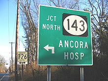 Sign for junction of Route 143 on southbound County Route 561
The alignment of Route 143 originates back to the creation of the state highway system in 1916, with the creation of State Highway Route 3 from Camden (in the namesake county) to Absecon in Atlantic County. The route was constructed as sections 7A and 2 of the alignment, with both being designated on April 1, 1918.[3][4] During the 1927 state highway renumbering, the New Jersey State Highway Department renumbered former Route 3 to State Highway Route 43.[5] The route used the same alignment of Route 3 for the several decades it existed, gaining one spur route in the process, State Highway Route S-43 in 1938 from Germania to Northfield.[6] The routes remained intact until the 1953 New Jersey state highway renumbering, when Route 43, which was mostly concurrent with U.S. Route 30 beforehand, was decommissioned in favor of the U.S. Route.[7] Route 43's alignment, however, was retaken by the state in 1955 as Section 11E of the highway.[8] The route received its designation of Route 143 on June 14, 1989 when the State Legislature approved the new designation.[9]
Major intersections
The entire route is in Winslow Township, Camden County.
Mile[1] Destinations Notes 0.00 CR 561 (Egg Harbor Road) / CR 726 south (Spring Garden Road)Southern terminus 2.27 US 30 (White Horse Pike)2.35 CR 716 north (Old White Horse Pike)Northern terminus 1.000 mi = 1.609 km; 1.000 km = 0.621 mi See also
 U.S. Roads portal
 New Jersey portal
References
- ^ a b c d e f g "Route 143 straight line diagram". New Jersey Department of Transportation. http://www.state.nj.us/transportation/refdata/sldiag/00000143__-.pdf. Retrieved 2009-10-08.
- ^ a b Google, Inc. Google Maps – overview of New Jersey Route 143 (Map). Cartography by Google, Inc. http://maps.google.com/maps?f=d&source=s_d&saddr=S+Egg+Harbor+Rd+%26+New+Jersey+143,+Batsto,+Camden,+New+Jersey+08037&daddr=U.S.+30+%26+New+Jersey+143,+Camden,+New+Jersey&geocode=FRZLXQIdf66J-w%3BFf28XQIdJPaJ-yndOoPXPSnBiTHnVVMAhRhwEg&hl=en&mra=pe&mrcr=0&sll=39.683081,-74.853806&sspn=0.060374,0.110378&ie=UTF8&t=h&z=14. Retrieved 2009-10-08.
- ^ Plan and Profile for Route 3: Section 7A. New Jersey State Highway Department. 1918.
- ^ Plan and Profile for Route 3: Section 2. New Jersey State Highway Department. 1918.
- ^ ROUTE No. 43. CAMDEN TO ABSECON, by way of Berlin, Hammonton, Egg Harbor City to Absecon.. New Jersey State Legislature. 1927.
- ^ ROUTE NO. S43--extending from Route No. 43 at Germania to Route No. 4 at Northfield.. New Jersey State Legislature. 1938. pp. 511.
- ^ 1953 renumbering, New Jersey Department of Highways, http://en.wikisource.org/wiki/1953_New_Jersey_state_highway_renumbering, retrieved July 31, 2009
- ^ Legislation retaking the portion of Route 43 for state-maintenance, 1955
- ^ Request by the New Jersey Department of Transportation for Route 143's designation accepted, June 14, 1989
External links
Categories:- State highways in New Jersey
- Transportation in Camden County, New Jersey


Wikimedia Foundation. 2010.