- Owlshead Mountains
-
Owlshead Mountains Mountain Range  Death Valley landmarks
Country United States State California District San Bernardino County Coordinates 35°43′44.863″N 116°44′14.133″W / 35.72912861°N 116.73725917°W Highest point - elevation 712 m (2,336 ft) Timezone Pacific (UTC-8) - summer (DST) PDT (UTC-7) Topo map USGS Owl Lake 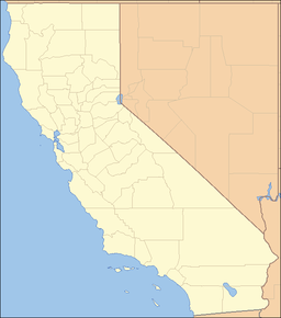
 location of Owlshead Mountains in California [1]
The Owlshead Mountains are located at the southern end of Death Valley National Park near the border of the Fort Irwin Military Reservation in San Bernardino County, California, USA.
Contents
Geography
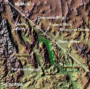
The range lies in the Mojave Desert, north of the Granite Mountains and the Avawatz Mountains, south of the Black Mountains forming the bottom of Death Valley. The Greenwater Range is to the northeast, the Slate Range is west, and the Kingston Range east.
The mean annual precipitation in the range is five inches or less. The Owlshead Mountains are arranged in a semi-circular pattern, with the Amargosa River lying to the north.
References
External links
See also
- Mountain ranges of the Mojave Desert
Death Valley and Death Valley National Park Fauna, flora and minerals Amargosa springsnail · Borax · Chuckwalla · Death Valley monkeyflower · Death Valley pupfish · Death Valley June beetle · Devil's Hole pupfish · Saratoga Springs pupfish
History Amargosa Opera House and Hotel · Badwater · Death Valley Railroad · Greenwater · Harmony Borax Works · Lake Manly (Badwater Basin) · Skidoo · Tonopah and Tidewater Railroad · Twenty-mule team
Places Amargosa Range / River / Valley · Ash Meadows NWR · Badwater Basin · Ballarat · Beatty · Black Mountains · Chloride City · Cottonwood Mountains · Darwin Falls · Death Valley Junction · Eureka Valley / Dunes · Funeral Mountains · Furnace Creek · Panamint City / Range / Springs / Valley · Racetrack · Rhyolite · Saline Valley · Saratoga Springs · Scotty's Castle · Stovepipe Wells · Telescope Peak · Trona · Ubehebe Crater · Zabriskie Point
Transportation Categories:- Death Valley
- Mountain ranges of the Mojave Desert
- Mountain ranges of San Bernardino County, California
- Mountain ranges of Southern California
- Death Valley National Park
- San Bernardino County, California geography stubs
Wikimedia Foundation. 2010.