- Crow River (Minnesota)
-

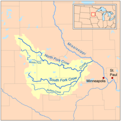
The Crow River is a tributary of the Mississippi River in south-central Minnesota in the United States. It drains a watershed of 2,756 square miles (7,138 km²).
Contents
Hydrography
The Crow River flows for most of its length as three streams:
- The North Fork Crow River, about 120 miles (195 km) long, flows from Grove Lake in eastern Pope County and follows a generally east-southeastward course through southwestern Stearns, northeastern Kandiyohi, northern Meeker and central Wright Counties, through Rice Lake and Lake Koronis and past the towns of Regal, Paynesville and Kingston. A minor headwaters tributary of the North Fork is named Skunk River.
- The Middle Fork Crow River, about 50 miles (80 km) long, rises near Belgrade in southwestern Stearns County and flows into Kandiyohi County, initially southward through Mud Lake and Nest Lake and past the town of New London, then eastward through Green Lake and Calhoun Lake and into northern Meeker County, where it joins the North Fork.
- The South Fork Crow River, about 100 miles (160 km) long, flows from Wagonga and Little Kandiyohi Lakes in south-central Kandiyohi County and follows a generally eastward course through southwestern Meeker, northern McLeod, northwestern Carver and southeastern Wright Counties, past the towns of Cosmos, Hutchinson, Lester Prairie, Mayer, Watertown and Delano. Portions of the South Fork's upper course have been heavily straightened and channelized.
 The Crow as it flows through Hanover.
The north and south forks converge at Rockford to form the Crow River, which flows for about 30 miles (50 km) northeastward. The river's course is used to define the boundary between Wright and Hennepin Counties.
The Crow flows past Greenfield, Hanover, St. Michael, Otsego and Dayton; it enters the Mississippi River from the south at the common boundary between Otsego and Dayton.
See also
- List of Minnesota rivers
Coordinates: 45°14′45″N 93°31′21″W / 45.2457984°N 93.5224579°W[1]
References
- Columbia Gazetteer of North America entry
- Waters, Thomas F. (1977). The Streams and Rivers of Minnesota. Minneapolis: University of Minnesota Press. ISBN 0-8166-0960-8.
External links
Categories:- Rivers of Minnesota
- Tributaries of the Mississippi River
- Geography of Hennepin County, Minnesota
- Geography of Pope County, Minnesota
- Geography of Stearns County, Minnesota
- Geography of Kandiyohi County, Minnesota
- Geography of Meeker County, Minnesota
- Geography of Wright County, Minnesota
- Geography of McLeod County, Minnesota
- Geography of Carver County, Minnesota
- Minnesota geography stubs


Wikimedia Foundation. 2010.