- Mynydd Mawr
-
Mynydd Mawr 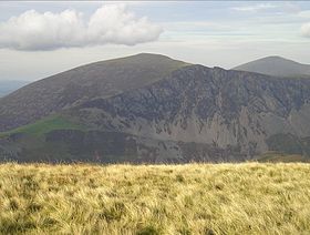
Mynydd Mawr from Trum y DdysglElevation 698 m (2,290 ft) Prominence 462 m (1,516 ft) Parent peak Moel Hebog Listing Marilyn, Hewitt, Nuttall Translation big mountain (Welsh) Pronunciation Welsh: [ˈmənɨð ˈmaur] Location Location Gwynedd,  Wales
WalesRange Snowdonia Topo map OS Landranger 115 OS grid SH539546 Mynydd Mawr (Welsh for big mountain) is a mountain in Snowdonia, North Wales, situated approximately 7 km (4.3 mi) west of Snowdon itself, overlooking Llyn Cwellyn and being the northern outlier of the Moel Hebog group. A popular ascent starts from Rhyd Ddu. On its western flank are the remains of ancient settlements and field systems. The profile of Mynydd Mawr from the north is often thought to resemble an elephant lying down, and consequently the mountain is often colloquially also called "Elephant Mountain".[1]
References
- ^ Nuttall, John & Anne (1999). The Mountains of England & Wales - Volume 1: Wales (2nd edition ed.). Milnthorpe, Cumbria: Cicerone. ISBN 1-85284-304-7.
External links
- Walking guide and photographs here and here.
- www.geograph.co.uk : photos of Mynydd Mawr and surrounding area
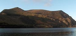 Mynydd Mawr and Llyn Cwellyn from the east
Coordinates: 53°04′07″N 4°10′55″W / 53.06860°N 4.18200°W
Categories:- Hewitts of Wales
- Marilyns of Wales
- Mountains and hills of Snowdonia
- Nuttalls
- Sites of Special Scientific Interest in West Gwynedd
- Gwynedd geography stubs


Wikimedia Foundation. 2010.