- Brooks Range
Geobox|Range
name=Brooks Range
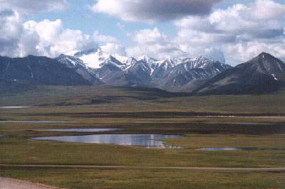
image_caption=Brooks Range from near Galbraith Lake
country=United States |country1=Canada
region=Alaska |region1=Yukon
unit=
border=
length_imperial=| length_orientation=
width_imperial= | width_orientation=
highest=Mount Chamberlin
highest_elevation_imperial=9020
highest_lat_d=69|highest_lat_m=16|highest_lat_s=39|highest_lat_NS=N
highest_long_d=144|highest_long_m=54|highest_long_s=40|highest_long_EW=W
geology= | period= | orogeny=
map_caption=The Brooks Range is amountain range that stretches from west to east across northernAlaska and intoCanada 'sYukon Territory , a total distance of about 1100 km (700 mi). The mountains are not especially high, topping out at over 2,700 m (9,000 ft). This mountain range forms the northern-most drainage divide in North America, separating streams flowing into the Arctic Ocean and the North Pacific. The range roughly delineates the summer position of the Arctic front. It represents the northern extent oftree line , with no trees (apart from some isolatedBalsam poplar stands) occurring north of the continental drainage divide. Mount Chamberlin, 9020 ft (2,749 m), is the highest peak in the range. Other notable peaks includeMount Isto , 8,975 ft (2,736 m) and Mount Michelson, 8,855 ft (2,699 m).Some sources (including theUSGS 1:250,000 scale map) quote Mount Isto's height as 9,050 ft, which would make it the highest point in the range. Also, some sources quote Mount Michelson's height as 9,239 ft, which would make it the highest point; however this is far above the 8,855 foot figure given on bothUSGS topographic maps, so it is unlikely to be correct.]The range is mostly uninhabited, but the
Dalton Highway and theTrans-Alaska Pipeline System run through theAtigun Pass (1,415 m, 4,643 ft) on their way to the North Slope and theoil field s atPrudhoe Bay . TheAlaska Native villages of Anaktuvuk and Arctic Village, as well as the very small communities of Coldfoot, Wiseman, Bettles, and Chandalar Lake are the only settlements in the 700-mile Brooks Range. In the far west, near the Wulik River in the De Long Mountains is theRed Dog Mine, Alaska , largest zinc mine in the world.As one of the most remote and least-disturbed wildernesses of North America, the mountains are teeming with wildlife, including
Dall sheep ,grizzly bear s, andcaribou .The range was named by the USGS in 1925 after
Alfred Hulse Brooks , who was the chief USGS geologist for Alaska from 1903 to 1924.Various historical records also referred to the range as the Arctic Mountains, Hooper Mountains, Meade Mountains and Meade River Mountains; the Canadian portion is still often referred to as the British Mountains. The British Mountains are part of
Ivvavik National Park .Documented Wilderness Traverses of the Brooks Range
* Dick Griffith --
Kaktovik toKotzebue , Alaska (1959-1979) by foot, raft, and kayak: first documented traverse.
* Roman Dial --Kaktovik toKotzebue , Alaska (1986) by skis, foot,packraft andkayak : first traverse in one year.
* Keith Nyitray -- Fort McPherson, Northwest Territories, Canada toKotzebue (1989-1990) by dog sled, snowshoes, foot, raft, and canoe: first continuous traverse of the entire range. 1,500 trail miles fromCanada to Kotzebue. See April '93 issue of "National Geographic."
* Thor Tingey, Phillip Weidner, Sam Newburry, Dan Dryden -- Marsh Fork Canning River toKobuk (2000) by foot and packraft.
*Dennis Schmitt --Point Hope , Alaska toMackenzie River ,Northwest Territories (1966-2001) by foot and dog sled: longest and first full length traverse.
* Peter Vacco -- Bonnet Lake to Cape Lisburne (2003) by snowshoe and foot: first continuous foot traverse fromCanada .
* Roman Dial --Kivalina toDalton Highway without resupply (2006) by foot: fastest traverse (624 miles in 22 days, 7 hours, 40 minutes).
* Bruce Nelson --Yukon border toKotzebue Sound (2006) by foot and raft.
* The range is believed to be approximately 126 million years old.Films
*2007 - "Gates of the Arctic: Alaska's Brooks Range"
ee also
*
Richardson Mountains References
* [http://www.bucktrack.com/Alaska_Brooks_Range_Traverse.html Alaska -- Brooks Range Traverse]
* [http://www.ryanjordan.com/ Arctic 1000]
* [http://www.aktrekking.com/Brooks.html Arctic National Wildlife Refuge trek]Notes
Further reading
*Dover, J.H., I.L. Tailleur, and J.A. Dumoulin. (2004). "Geologic and fossil locality maps of the west-central part of the Howard Pass quadrangle and part of the adjacent Misheguk Mountain quadrangle, Western Brooks Range, Alaska" [Miscellaneous Field Studies; Map MF-2413] . Reston, VA: U.S. Department of the Interior, U.S. Geological Survey.
*Krumhardt, A.P., A.G. Harris, and K.F. Watts. (1996). "Lithostratigraphy, microlithofacies, and conodont biostratigraphy and biofacies of the Wahoo Limestone (Carboniferous), eastern Sadlerochit Mountains, northeast Brooks Range, Alaska" [U.S. Geological Survey Professional Paper 1568] . Washington, D.C.: U.S. Department of the Interior, U.S. Geological Survey.
*Marshall, R. (1970). "Alaska wilderness; exploring the Central Brooks Range" 2nd ed. Berkeley: University of California Press.
*Morin, R.L. (1997). "Gravity and magnetic maps of part of the Drenchwater Creek stratiform zinc-lead-silver deposit, Howard Pass quadrangle, northwestern Brooks Range, Alaska" [U.S. Geological Survey Open-file Report 97-705] . Menlo Park, CA: U.S. Department of the Interior, U.S. Geological Survey.
*Morin, R.L. (1997). "Gravity models of Abby Creek and Bion barite deposits, Howard Pass quadrangle, northwestern Brooks Range, Alaska" [U.S. Geological Survey Open-file Report 97-705] . Menlo Park, CA: U.S. Department of the Interior, U.S. Geological Survey.
*Mull, C.G. et al. (1994). "Geologic map of the Killik River quadrangle, Brooks Range, Alaska" [U.S. Geological Survey Open-file Report 94-679] . Reston, VA: U.S. Department of the Interior, U.S. Geological Survey.
*Nelson, P.H. et al. (2006). "Potential tight gas resources in a frontier province, Jurassic through Tertiary strata beneath the Brooks Range foothills, Arctic Alaska" [U.S. Geological Survey Open-file Report 2006-1172] . Reston, VA: U.S. Department of the Interior, U.S. Geological Survey.
*U.S. Department of the Interior, U.S. Geological Survey. (2003). "The natural dispersal of metals to the environment in the Wulik River-Ikalukrok Creek area, western Brooks Range, Alaska" [U.S. Geological Survey Fact Sheet 107-03] . Reston, VA: author.
*U.S. Department of the Interior, U.S. Geological Survey. (1995). "Natural environmental effects of silver-lead-zinc deposits in the Brooks Range, Alaska" [U.S. Geological Survey Fact Sheet 092-95] . Reston, VA: author.
Wikimedia Foundation. 2010.