- Nazca Lines
-
Coordinates: 14°43′00″S 75°08′00″W / 14.7166667°S 75.1333333°W
Lines and Geoglyphs of Nazca and Pampas de Jumana * UNESCO World Heritage Site
Country Peru Type Cultural Criteria i, iii, iv Reference 700 Region ** Latin America and the Caribbean Inscription history Inscription 1994 (18th Session) * Name as inscribed on World Heritage List
** Region as classified by UNESCOThe Nazca Lines are a series of ancient geoglyphs located in the Nazca Desert in southern Peru. They were designated a UNESCO World Heritage Site in 1994. The high, arid plateau stretches more than 80 kilometres (50 mi) between the towns of Nazca and Palpa on the Pampas de Jumana about 400 km south of Lima. Although some local geoglyphs resemble Paracas motifs, scholars believe the Nazca Lines were created by the Nazca culture between 400 and 650 AD.[1] The hundreds of individual figures range in complexity from simple lines to stylized hummingbirds, spiders, monkeys, fish, sharks, orcas, llamas, and lizards.
The lines are shallow designs made in the ground by removing the ubiquitous reddish pebbles and uncovering the whitish ground beneath. Hundreds are simple lines or geometric shapes; more than seventy are zoomorphic designs of animals such as birds, fish, llamas, jaguar, monkey, or human figures. Other designs include phytomorphic shapes such as trees and flowers. The largest figures are over 200 metres (660 ft) across. Scholars differ in interpreting the purpose of the designs, but in general they ascribe religious significance to them.
The geometric ones could indicate the flow of water or be connected to rituals to summon water. The spiders, birds, and plants could be fertility symbols. Other possible explanations include: irrigation schemes or giant astronomical calendars.[2]
Due to the dry, windless, and stable climate of the plateau and its isolation, for the most part the lines have been preserved. Extremely rare changes in weather may temporarily alter the general designs.
Contents
Discovery and construction
After people travelled over the area by plane in the 1930s and saw the Nazca Lines from the air, anthropologists started studying them, with focus on trying to understand how they were created.
Scholars have theorized the Nazca people could have used simple tools and surveying equipment to construct the lines. Studies have found wooden stakes in the ground at the end of some lines, which support this theory. One such stake was carbon-dated and the basis for establishing the age of the design complex. Researcher Joe Nickell of the University of Kentucky has reproduced the figures by using tools and technology available to the Nazca people. The National Geographic called his work "remarkable in its exactness" when compared to the actual lines.[3] With careful planning and simple technologies, a small team of people could recreate even the largest figures within days, without any aerial assistance.[4] Most of the lines form a trench about 15 centimetres (5.9 in) deep.
The lines were made by removing the reddish-brown iron oxide-coated pebbles that cover the surface of the Nazca desert. When the gravel is removed, it leaves a shallow trough ranging from 10 centimetres (3.9 in) to 15 centimetres (5.9 in) deep and the light-colored earth beneath shows in lines of sharply contrasting color and tone. This sublayer contains high amounts of lime which with the morning mist hardens forming a protective layer that shields the lines from winds therefore preventing erosion.
The Nazca "drew" several hundred simple but huge curvilinear animal and human figures by this technique. In total, the earthwork project is huge and complex: the area encompassing the lines is nearly 500 square kilometres (190 sq mi), and the largest figures can span nearly 270 metres (890 ft). The extremely dry, windless, and constant climate of the Nazca region has preserved the lines well. The Nazca desert is one of the driest on Earth and maintains a temperature around 25 °C (77 °F) all year round. The lack of wind has helped keep the lines uncovered and visible to the present day.
 Nazca Lines seen from SPOT Satellite
Purpose
Archeologists, ethnologists, and anthropologists have studied the ancient Nazca culture and the complex to try to determine the purpose of the lines and figures. One theory is that the Nazca people created them to be seen by their gods in the sky. Kosok and Reiche advanced a purpose related to astronomy and cosmology: the lines were intended to act as a kind of observatory, to point to the places on the distant horizon where the sun and other celestial bodies rose or set. Many prehistoric indigenous cultures in the Americas and elsewhere constructed earthworks that combined such astronomical sighting with their religious cosmology, as did the later Mississippian culture at Cahokia in present-day United States. Another example is Stonehenge in England. But, Gerald Hawkins and Anthony Aveni, experts in archaeoastronomy, concluded in 1990 that there was insufficient evidence to support such an astronomical explanation.[5]
In 1985, the archaeologist Johan Reinhard published archaeological, ethnographic, and historical data demonstrating that worship of mountains and other water sources predominated in Nazca religion and economy from ancient to recent times. He theorized that the lines and figures were part of religious practices involving the worship of deities associated with the availability of water, which directly related to the success and productivity of crops. He interpreted the lines as sacred paths leading to places where these deities could be worshiped. The figures were symbols representing animals and objects meant to invoke the gods' aid in supplying water. But, the precise meanings of many of the individual geoglyphs remain unsolved as of 2011.
Henri Stierlin, a Swiss art historian specializing in Egypt and the Middle East, published a book in 1983 linking the Nazca Lines to the production of ancient textiles that archeologists have found wrapping mummies of the Paracas culture.[6] He contended that the people may have used the lines and trapezes as giant, primitive looms to fabricate the extremely long strings and wide pieces of textile that are typical of the area. By his theory, the figurative patterns (smaller and less common) were meant only for ritualistic purposes.
Alternative theories
 Satellite picture of an area containing lines. North is to the right. (Coordinates: 14°43′S 75°08′W / 14.717°S 75.133°W)
Some individuals propose alternative theories. Jim Woodmann believes that the Nazca Lines could not have been made without some form of manned flight to see the figures properly. Based on his study of available technology, he suggests that a hot air balloon was the only possible means of flight. To test this hypothesis, Woodmann made a hot-air balloon using materials and techniques that he understood to be available to the Nazca people. The balloon flew, after a fashion. Most scholars have rejected Woodmann's thesis as ad hoc,[4] because of the lack of any evidence of such balloons.[7]
Swiss author Erich von Däniken suggests the Nazca lines and other complex constructions represent higher technological knowledge than commonly believed to be existing when the glyphs were created. Von Däniken maintains that the Nazca lines in Peru are runways of an ancient airfield that was used by extraterrestrials mistaken by the natives to be their gods.
Maria Reiche's protege Phillis Pitluga, an astronomer at the Adler Planetarium & Astronomy Museum, believes, based on computer-aided studies of star alignments, that the giant spider figure is an anamorphic diagram of the constellation Orion. She further suggests that three of the straight lines leading to the figure were used to track the changing declinations of the three stars of Orion's Belt but does not take into account the other twelve lines. Aveni has commented on her work, saying:
I really had trouble finding good evidence to back up what she contended. Pitluga never laid out the criteria for selecting the lines she chose to measure, nor did she pay much attention to the archaeological data Clarkson and Silverman had unearthed. Her case did little justice to other information about the coastal cultures, save applying, with subtle contortions, Urtons representations of constellations from the highlands. As historian Jacquetta Hawkes might ask: was she getting the pampa she desired?[8]
Environmental concerns
People trying to preserve the Nazca Lines are concerned about threats of pollution and erosion caused by deforestation in the region.
The Lines themselves are superficial, they are only 10 to 30 cm deep and could be washed away... Nazca has only ever received a small amount of rain. But now there are great changes to the weather all over the world. The Lines cannot resist heavy rain without being damaged.
– Viktoria Nikitzki of the Maria Reiche Centre[9]After flooding and mudslides in the area in mid-February 2007, Mario Olaechea Aquije, archaeological resident from Peru's National Institute of Culture, and a team of specialists surveyed the area. He said, "[T]he mudslides and heavy rains did not appear to have caused any significant damage to the Nazca Lines," but the nearby Southern Pan-American Highway did suffer damage, and "the damage done to the roads should serve as a reminder to just how fragile these figures are."[10]
Images
 The Hummingbird
 The Condor
 The Heron
 The "Astronaut"
 The Spider
 The Pelican
 The Dog
 The Hands
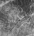 The Monkey
See also
- Iperu, tourist information and assistance
- Tourism in Peru
- Maria Reiche
- Marilyn Bridges
- Simone Waisbard
- List of archaeoastronomical sites sorted by country
Notes
- ^ Helaine Silverman, David Browne (1991). "New evidence for the date of the Nazca lines". Antiquity 65 (247): 208–220. http://www.antiquity.ac.uk/Ant/065/Ant0650208.htm
- ^ Brown, Cynthia Stokes (2007). Big History. New York: The New Press. pp. 167. ISBN 978-1-59558-196-9.
- ^ Nickell, Joe (2005). Unsolved History: Investigating Mysteries of the Past, The University Press of Kentucky ISBN 978-0813191379, pp. 13-16
- ^ a b Katherine Reece, "Grounding the Nasca Balloon", Into the Hall of Ma'at website
- ^ Cameron, Ian (1990). Kingdom of the Sun God: a history of the Andes and their people. New York: Facts on File. p. 46. ISBN 0-8160-2581-9.
- ^ Stierlin (1983)
- ^ Haughton (2007)
- ^ Aveni, Anthony F. Between the Lines: The Mystery of the Giant Ground Drawings of Ancient Nasca, Peru . Austin Texas: University of Texas Press. 1 July 2006 ISBN0292704968 p.205 [1]
- ^ Shafik Meghji, "Flooding and tourism threaten Peru's mysterious Nazca Lines", The Independent, July 17, 2004. Accessed April 02, 2007.
- ^ Living in Peru. "Peru: Nazca Lines escape mudslides", Living in Peru, February 20, 2007. Accessed April 02, 2007.
References
- Aveni, Anthony F. (ed.) (1990). The Lines of Nazca. Philadelphia: American Philosophical Society. ISBN 0-87169-183-3
- Haughton, Brian. (2007). Hidden History: Lost Civilizations, Secret Knowledge, and Ancient Mysteries. Career Press. ISBN 1564148971
- Lambers, Karsten (2006). The Geoglyphs of Palpa, Peru: Documentation, Analysis, and Interpretation. Lindensoft Verlag, Aichwald/Germany. ISBN 3-929290-32-4
- Reinhard, Johan (1996) (6th ed.) The Nazca Lines: A New Perspective on their Origin and Meaning. Lima: Los Pinos. ISBN 84-89291-17-9
- Sauerbier, Martin. GIS-based management and analysis of the geoglyphs in the Palpa region. ETH (2009). doi:10.3929/ethz-a-005940066.
- Stierlin, Henri (1983). La Clé du Mystère. Paris: Albin Michel. ISBN 2226018646
- von Däniken, Erich (2003). Arrival of the Gods: Revealing the Alien Landing Sites of Nazca. Vega, London. ISBN 1-84333-053-9; first published (1977) as "Zeichen für die Ewigkeit". Bertelsmann Verlag, Munich.
Further reading
- Johnson, Emma. 2007. The 'Mysterious' Nazca Lines. PARA Web Bibliography B-01.
External links
- Nazca Designs and Lines at Discover Peru
- Nazca Lines photos
- Tragedies flying over the Nazca lines
- Nazca lines at the Open Directory Project
- Nazca Lines in Google Earth
World Heritage Sites in Peru 
Chan Chan Archaeological Zone · Chavín Archaeological Site · City of Cuzco · Historic Centre of Lima · Historical Centre of the City of Arequipa · Historic Sanctuary of Machu Picchu · Huascarán National Park · Manú National Park · Lines and Geoglyphs of Nasca and Pampas de Jumana · Rio Abiseo National Park · Sacred City of Caral-Supe
Categories:- World Heritage Sites in Peru
- Archaeoastronomy
- Archaeological sites in Peru
- Geoglyphs
- Prehistoric art
- Land art
- Prehistoric inscriptions


Wikimedia Foundation. 2010.