- Messenia
-
For the ancient region, see Messenia (ancient region).
Messenia
Περιφερειακή ενότητα
Μεσσηνίας— Regional unit — Municipalities (dimi) of Messinia, 2010:
- Kalamata
- Mani
- Messini
- Oichalia
- Pylos-Nestoras
- Trifylia
Messenia within Greece
Coordinates: 37°10′N 22°0′E / 37.167°N 22°ECoordinates: 37°10′N 22°0′E / 37.167°N 22°E Country Greece Region Peloponnese Capital Kalamata Area - Total 2,991 km2 (1,154.8 sq mi) Population (2001) - Total 176,876 - Density 59.1/km2 (153.2/sq mi) Postal codes 24x xx Area codes 272x0, 276x0 ISO 3166 code GR-17 Car plates ΚΜ  Kalamata castle
 Port of Kalamata
 Messenia from Mt. Ithome
 View of Pylos on the Bay of Navarino
Messenia (Greek: Μεσσηνία Messinia pronounced [męssinia]) is a regional unit (perifereiaki enotita) in the southwestern part of the Peloponnese (region) region, one of 13 regions into which Greece has been divided by the Kallikratis plan, implemented 1 January 2011.[1] Before 2011 Messenia existed as a major subdivision of Greece, according to Law 2539 of 1997, the Kapodistrias Plan, except that it was defined as a nomos (prefecture). The capital of Messenia in either case has been the city Kalamata.
Contents
Geography
Physical
Messenia borders on Elis to the north, Arcadia to the northeast, and Laconia to the southeast. The Ionian Sea lies to the west, and the Gulf of Messenia to the south. The most important mountain ranges are the Taygetus in the east, the Kyparissia mountains in the northwest and the Lykodimo in the southwest. The main rivers are the Neda in the north and the Pamisos in central Messenia.
Off the south coast of the southwesternmost point of Messenia lie the Messenian Oinousses islands. The largest of these are Sapientza, Schiza and Venetiko. The small island Sphacteria closes off the bay of Pylos. All these islands are virtually uninhabited.
Climate may vary, in the lowlands, temperatures are a bit warmer than Athens. Snow is not common during winter months except for the mountains especially the Taygetus. Rain and clouds are common inland.
Political
Reorganization of Messenia
Before the 2010 reorganization, Messenia was a nomos (prefecture) containing 29 dimoi (municipalities) and 2 koinotites (communities). The total population, based on the 2001 census was 176,876.[2] Since 2010, Messenia has been a perifereiake enoteta (regional unit) containing only 6 municipalities, but still with a population of 176,876;[3] i.e., Messenia did not change area in the reorganization. Some 25 municipalities and communities were incorporated politically into the other 6 according to the table below.[1]
New municipality Old municipalities Seat Kalamata Kalamata Kalamata Aris Arfara Thouria Messene
(Messini)Messene Messene Aipeia Androusa Aristomenis Voufrades Ithomi Petalidi Trikorfo Oichalia Oichalia Meligalas Andania Dorio Eira Meligalas Pylos-Nestoras Pylos Pylos Koroni Methoni Nestoras Papaflessas Chiliochoria Trifylia Kyparissia Kyparissia Aetos Avlonas Gargalianoi Filiatra Tripyla West Mani
(Dytiki Mani)Avia Kardamyli Lefktro Population
Year Population 1991 167,292 2001 172,875 The main cities and towns of Messenia are (ranked by 2001 census population):
- Kalamata 49,550
- Filiatra 7,882
- Messene 6,912
- Gargalianoi 6,336
- Kyparissia 5,708
- Chora (Nestoras) 3,500
- Pylos 2,561
Economy
 Voidokilia beach.
The economy of Messenia is primarily based on agricultural production although in recent years efforts are being made toward the development of activities in other sectors such as tourism.
Main agricultural products are olive oil, Kalamata table olives, figs, and black raisins (sultanas). The variety of agricultural products is complemented by a small amount of stockbreeding products (beef, milk, sfela cheese, honey) and fish from the Gulf of Messenia.
The tourist development observed is mainly attributable to the promotion of important archaeological sites, such as The Palace of Nestor and Ancient Messene, as well as to the beauty of the landscape. Another key factor for Messenia tourist economy is Costa Navarino, Greece’s biggest tourist development.[4]
There are many small- and medium-size firms involved in the processing and standardization of agricultural products as well as a number of enterprises devoted to wood processing, furniture manufacturing, and metal construction.
Transport
There are four major highways in Messenia:
- Greek National Road 7, N, Cen.
- Greek National Road 9, NW, W, SW
- Greek National Road 9A, NW, N
- Greek National Road 82, SW, Cen., E
Communications
Television
- Notioi Elliniki Teleorasi, (Southern Greece Television)
History
Ancient period
Main article: Messenia (ancient region) Ancient Theater in Messene.
Messenia is mentioned in the oldest European literature, the Iliad. The name undoubtedly goes back to at least the Bronze Age, but its origins are lost in the world of mythology.
Medieval period
In the Middle Ages, Messenia shared the fortunes of the rest of the Peloponnese. Striking reminders of these conflicts are afforded by the extant ruins of the medieval strongholds of Kalamata, Coron (anc. Asine, mod. Korone), Modon (Methone) and Pylos. Messenia was a part of the Byzantine Empire.
Ottoman and Venetian period
Much of Messenia fell into the hands of the Ottoman Turks, a part of the area remained with the Venetian Republic and a whole shortly in the mid to late-15th century. In 1534 a group of families, known as the 'Coroni', settled in Piana degli Albanesi in Sicily. They were Arvanites and Greeks from Koroni.
During the 1680s, the whole of Messenia was regained by the Venetian Republic in the Morean War.In the 1730s it reverted back to the Ottomans[citation needed]. The Mani Peninsula, a part of modern Messenia, was autonomous from Turkish rule due to the fact that it had no harbors.
Modern period
From the Greek War of Independence through World War II
Messenia did not became Greek until the Greek War of Independence of 1821 and several months and years later was liberated by the Greeks. One of the most famous battles was the Battle of Navarino which took place in the middle of the war and defeated its Turkish fleets. Messenia had improved its economy including its agriculture in the first years of the modern country of Greece. It was later connected by rail (Piraeus, Athens and Peloponnese Railways or SPAP, today part of OSE) and four highways. Emigration to the United States and later larger towns and cities including Athens also began slowly. The prefecture later included the Ionian Islands of Sapientza and Schiza.
From the Greek Civil War to the present
After World War II and the Greek Civil War, most of its buildings were rebuilt. Emigration increased and later included much of North America and Australia and later western Europe and slowed down in the 1980s and continues in villages. The population in the area of Kalamata and Messene boomed from 30,000 before the war up to nearly 80,000 in the present day.
The highway bypassed Messene in the 1970s. In 1999, the construction of the GR-7 was opened and added an interchange in the mid-2000s with the GR-9. The Ministry of Transportation will extend the bypass with two lanes downward to Kalamata with the bypass that opened in 2004, it length will be approximately 30 km, the section will open as early as 2012. The next construction program is uncertain with the exception of the possible proposal of the GR-9A from Kalo Neri to the GR-7 connecting the GR-9 which the date is unset. The eastern portion is bypassed and features an interchange.
On Thursday July 26, 2007, the central part of the prefecture was stricken by a small fire that consumed several forests, groves and farms and ruined a part of its economy. Some houses were destroyed in villages that are built in a valley. The fire lasted into July 28. Nearly a month later, another fire ravaged the northeastern portion of the prefecture and consumed villages in the Taygetos ranges. It lasted from August 26 to August 27 and ruined many bushes, it did not affect southwest into the GR-9A Junction due to low winds and cooler weather. Firefighters along with airplanes, fire trucks and choppers battled the blaze, most of its water came from Lake Taka. Another natural disaster became earthquakes (see Earthquakes in Greece), a high medium earthquake ravaged and shook the entire prefecture, it measured at 6.6 on the Richter scale on Thursday February 14, 2008. Kalamata and Methoni became dangerous places as damages were rarely reported, they were nearly on high alert which brought panic to Messenia. Messenia was not to escape the earthquakes but they were to be lighter, Anthoni was battered by a February 26 earthquake that measured around 5.5 and another on Thursday February 28 that battered Methoni and caused only minor damages on these two earthquakes, some of its old houses were damaged from it. Messenia did not escape the quakes once again, four earthquakes battered portions of the prefecture near Methoni, all measured around 4 on the Richter scale, all of these occurred at the sea which relieved most of the shakiness.
See also
Notes
- ^ a b η Βουλή 2010, p. 17435
- ^ Hellenic Interior Ministry 2001, Lines 6652-7027.
- ^ η Βουλή 2010, p. 17434.
- ^ Bloomberg webpage
Bibliography
- Hellenic Interior Ministry (18 March 2001). "Δείτε τη Διοικητική Διαίρεση" (in Greek). Hellenic Interior Ministry. http://www.ypes.gr/UserFiles/f0ff9297-f516-40ff-a70e-eca84e2ec9b9/D_diairesi.xls.. The previous Kapodistrias organization of all the communities in Greece. The populations are from the Census of 2001.
- η Βουλή (11 August 2010), "ΤΕΥΧΟΣ ΔΕΥΤΕΡΟ" (in Greek), NOMOΣ ΥΠ’ΑΡΙΘ. 3852: Νέα Αρχιτεκτονική της Αυτοδιοίκησης και της Αποκεντρωμένης Διοίκησης − Πρόγραμμα Καλλικράτης, ΕΦΗΜΕΡΙΣ ΤΗΣ ΚΥΒΕΡΝΗΣΕΩΣ ΤΗΣ ΕΛΛΗΝΙΚΗΣ ΔΗΜΟΚΡΑΤΙΑΣ, http://www.kedke.gr/uploads2010/FEKB129211082010_kallikratis.pdf. Part 2 of the Kallicratis Plan law, No. 3852, by the Hellenic Parliament (Βουλή), publishing a table of all the official communities of Greece arranged in hierarchical order. The lowest-level populations are from the Census of 2001. All higher-level populations are the sums of the appropriate lower-level populations.
- Kontogiannis, N.D. "Settlements and countryside of Messenia during the late Middle Ages: the testimony of the fortifications," Byzantine and Modern Greek Studies, 34,1 (2010), 3-29.
 This article incorporates text from a publication now in the public domain: Chisholm, Hugh, ed (1911). Encyclopædia Britannica (11th ed.). Cambridge University Press.
Administrative division of the Peloponnese Region Area: 15,490 km² • Population : 638,942 (2001) • Capital: Tripoli Regional unit of Arcadia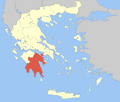 Regional unit of ArgolisRegional unit of CorinthiaRegional unit of LaconiaRegional unit of Messenia
Regional governor: Petros Tatoulis (el) • Website: ppel.gov.gr Prefectures of Greece Achaea and Elis (1833) · Achaea (1899) · Adrianople (1920)‡ · Aetolia-Acarnania (1833) · Arcadia (1833) · Argolis and Corinthia (1833) · Argolis (1899) · Argyrokastron (1915)§ · Arta (1882) · Attica and Boeotia (1833) · Attica (1899) · Boeotia (1899) · Chalkidiki (1915) · Chania (1912) · Chios (1915) · Corfu (1864) · Corinthia (1899) · Cyclades (1833) · Dodecanese (1947) · Drama (1915) · Elis (1899) · Euboea (1833) · Evros (1920) · Evrytania (1899) · Florina (1915) · Grevena (1964) · Heraklion (1912) · Imathia (1947) · Ioannina (1915) · Kallipolis (1920)‡ · Karditsa (1899) · Kastoria (1941) · Kavala (1915) · Kefallinia (1864) · Kilkis (1934) · Korytsa (1915)§ · Kozani (1915) · Lacedaemon (1899) · Laconia (1833) · Lakoniki (1899) · Larissa (1882) · Lasithi (1912) · Lefkada (1864) · Lesbos (1915) · Magnesia (1899) · Messenia (1833) · Pella (1930) · Phocis and Locris (1833) · Phocis (1899) · Phthiotis and Phocis (1845) · Phthiotis (1899) · Pieria (1947) · Piraeus (1964) · Preveza (1915) · Rethymno (1912) · Rhaedestos (1920)‡ · Rhodope (1920) · Samos (1915) · Saranta Ekklisies (1920)‡ · Serres (1915) · Sfakia (1912) · Thesprotia (1937) · Thessaloniki (1914) · Trikala (1882) · Trifylia (1899) · Xanthi (1944) · Zakynthos (1864)
From 1971, Attica Prefecture consisted of four prefecture-level units: Athens, East Attica, Piraeus, West Attica
From 1994, the prefectures of Athens and Piraeus; Drama, Kavala and Xanthi; Rhodope and Evros; were grouped intro super-prefecturesdates of first establishment in parentheses
today outside Greece: § in Northern Epirus ‡ in Eastern ThraceCategories:- Messenia
- Prefectures of Greece
- Regional units of Greece
- Kalamata


Wikimedia Foundation. 2010.