- North-West Frontier Province
Pakistan infobox
region = North-West Frontier Province
capital =Peshawar
latd = 34.00
longd = 71.32
pop_year = 2008
population = 20,215,000 (Estimate)
density_km2 = 259.6
area_km2 = 74,521
languages = Pashto (official)
HindkoKhowar
Punjabi
PersianUrdu (national) [ [http://www.pakpost.gov.pk/philately/stamps2003/centenary_celebrations_of_nwpf.html Centenary Celebrations of N.W.F.P. - Government of Pakistan] ]
status = Province
districts = 24
TMAs = 54
towns =
unions = 986
established = 1st July 1970
governor =Owais Ahmed Ghani
minister =Ameer Haider Khan Hoti
legislature = Provincial Assembly
seats = 124
website = http://www.nwfp.gov.pk
website_title = Government of the NWFP
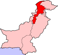
footnotes = The North-West Frontier Province (NWFP) (Urdu : śimāl maġribī sarhadī sūba Nastaliq|شمال مغربی سرحدی صوبہ) is the smallest of the four main provinces ofPakistan . The NWFP is home to the majorityPashtuns (locally referred to as "Pukhtuns") as well as other smaller ethnic groups. The province bordersAfghanistan to the northwest, theNorthern Areas to the northeast,Azad Kashmir to the east,Federally Administered Tribal Areas (FATA) to the west and south, and Pakistani Punjab andIslamabad Capital Territory to the southeast. The principal language is Pashto and the provincial capital isPeshawar . The Pakistan Peoples Party, to accommodate a demand by theAwami National Party , proposed the province be changed toPakhtunkhwa . [Dawn News - [http://www.dawn.com/2008/05/25/top1.htm PPP out to tame presidency, empower parliament] ]Geography
The NWFP is largely located on the
Iranian plateau along the peripheral junction between theIndian subcontinent and theEurasian plate , and this has led to seismic activity in the past (see Kashmir Quake) [ [http://www.peakbagger.com/range.aspx?rid=43 Irania plateau] ] . The famousKhyber Pass links the province to Afghanistan, while theKohalla Bridge inCircle Bakote is a major crossing point over the Jhelum river in the east. The province has an area of (28,773 square miles) or 74,521 km² of Pakistani territory and its districts includeHazara Division , home to the town ofHavelian , the western starting point of theKarakoram Highway .The capital and largest city of the province is
Peshawar .Peshawar 's is divided into various sections with the Old City being notable for its "chai-khanas" (or tea houses) and other ancient structures. "Qissa Kahani Bazaar" and other parts of Peshawar can remind visitors of anArabian Nights tale with its myriad corridors and its multicultural vendors. The Afghan character of the city was enhanced by the refugees from Afghanistan and the burgeoning population of tribesmen who have flocked to the city from rural areas in search of employment.Other main cities include
Nowshera ,Mardan ,Mansehra ,Charsadda ,Ayubia ,Nathia Gali andAbbottabad . The province's main districts include Dera Ismail Khan, Kohat, Bannu, Peshawar, Abbottabad and Mansehra.The region varies in topography from dry rocky areas in the south to forests and green plains in the north. The climate can be extreme with intensely hot summers to freezing cold winters. Despite these extremes in weather, agriculture remains important and viable in the area. The hilly terrain of Swat,
Kalam ,Upper Dir , Naran and Kaghan is renowned for its beauty and attracts a great many tourists from neighbouring regions and from around the world. Swat-Kalam is also termed 'a piece ofSwitzerland ' as there are many landscape similarities between it and the mountainous terrain of Switzerland.It covers an area of convert|74521|km2|sqmi|0|abbr=on. According to the 1998 census, the total population of N.W.F.P. was approximately 17 million [ [http://www.nwfpbos.sdnpk.org/nwfpds/2000/5.htm District wise area and population of NWFP] ] out of whom 52% are males and 48% females. The density of population is 187 per km² and the intercensal change of population is of about 30%. Geographically the province could be divided into two zones: the northern one extending from the ranges of the
Hindu Kush to the borders of Peshawar basin; and the southern one extending from Peshawar to the Derajat basin. The northern zone is cold and snowy in winters with heavy rainfall and pleasant summers with the exception of Peshawar basin, which is hot in summer and cold in winter. It has moderate rainfall. The southern zone is arid with hot summers and relatively cold winters and scantly rainfall. Its climate varies from very cold (Chitral in the north) to very hot in places like D.I. Khan. The major rivers that criss cross the province are Kabul River, Swat River, Chitral River, Panjgora River, Bara River, Karam River, Gomal River and Zob River.Its snow-capped peaks and lush green valleys of unusual beauty attract tourists from far and wide while its art and architecture no less known than the historic
Khyber Pass . Once the cradle ofGandhara civilization, the area is now known for its devout Muslims who zealously guard their religion and culture and the way of life that they have been following for centuries.Climate
The
climate of North-West Frontier province varies immensely for a region of its size, most of the many climate types found in Pakistan.Chitral District
The north, comprising
Chitral District , has a typically continental steppe climate, with average annual precipitation ranging from 100 mm (4 inches) per year in the far north to 585 mm (23 inches) in Drosh in the south. Most of this precipitation from frontal cloudbands during the winter and heavythunderstorm s in the spring. Of Chitral's average 420 mm (16.5 inches) of rainfall per year, 350 mm (13.8 inches) falls from December to May. At high elevations in the Hindukush,snow fall can be much heavier than this and consequently largeglaciers are a prominent feature of the landscape. Snow also cuts off evenChitral town from the outside world for most of the year. Temperatures in the valleys vary from 40 °C (105 °F) in July to as low as -10 °C (15 °F) in January.In the previous few years flood have created problems in Mastujtehsil .Dir, Swat and Hazara
Further south, in the districts of Dir, Swat and Hazara, the climate becomes more typical of the Indian subcontinent, although a considerable proportion of the annual precipitation still comes from frontal cloudbands during the winter months.
The combination of a short but powerful (owing to orography) summer monsoon with frequent winter cloudbands gives a bimodal rainfall regime in central parts of NWFP. Dir and Hazara districts are some of the wettest places in Pakistan: annual rainfall at Dir averages 1475 mm (58 inches), of which 400 mm (15.75 inches) falls during the summer monsoon from July to September and twice that amount during the winter rainy season from December to April. At
Abbottabad further east, the annual rainfall averages about 1195 mm (47 inches), but as much as 635 mm (25 inches) falls during the south-west monsoon. In Swat, rather more sheltered, the annual rainfall averages around 840 mm (33 inches), with about 430 mm (17 inches) expected between June and September. A similar climate to that of Dir, though drier, prevails in a small area aroundParachinar in theFederally Administered Tribal Areas .In all areas October and November are the driest months with rainfalls generally under 30 mm (1.2 inches) per month except in the most exposed areas.
Temperatures in this region are somewhat warmer than in
Chitral , and even at convert|1200|m|ft|-2 in Abbottabad the heat and humidity can be oppressive during the monsoon season. In winter, most of Swat receives significant snowfall, but in Hazara temperatures usually are around 5 °C (41 °F).Southern North-West Frontier Province
This region, south of the Himalaya/Hindukush foothills, has the typically hot and dry climate of much of Pakistan. Temperatures in summer are quite oppressively hot, and in the south around Mardan temperatures of 45 °C (113 °F) are not uncommon, whilst in Peshawar 40 °C (104 °F) is par for the course in summer. In winter, however, this region is both warmer and generally drier than the rest of NWFP, with temperatures being around 17 °C (62 °F) in Peshawar and over 20 °C (68 °F) in the extreme south of the province. Nights, however, can still be quite cold during the winter.
Southern NWFP experiences little (and very erratic) monsoonal rain, with Peshawar and Dera Ismail Khan both averaging around 115 mm (4.5 inches) of rain in July and August and almost nothing in June or September. Moreover, in many years no summer rain of significance occurs. In winter, rainfall usually peaks in March but Peshawar averages less than 250mm (10 inches) between December and May and Dera Ismail Khan less than 115 mm (4.5 inches). On certain mountain slopes such as around
Kohat , winter rainfall may predominate, though this is unpredictable.Demographics and society
The province has an estimated population of roughly 21 million that does not include the almost 1.5 million
Afghan refugees [ [http://www.unhcr.org/news/NEWS/481856844.html Pakistani TV delves into lives of Afghan refugees - UNHCR] ] and their descendants in the province. [ [http://www.britannica.com/eb/article-9056228 britannica.com - North West Frontier] ] [ [http://www.unhcr.org/cgi-bin/texis/vtx/home/opendoc.pdf?tbl=SUBSITES&page=SUBSITES&id=434fdc702 UNHCR - Census of Afghans in Pakistan] ] . The largest ethnic group are thePashtuns who form about two-thirds of the population [ [http://nwfp.gov.pk/AIS-page.php?DistId=1&DeptId=1&LanId=1&pageName=NWFP-PeopleCulture People and culture - Government of the North-West Frontier Province] ] .Pashto is the most pervasive language while
Hindko is the second most commonly spoken indigenous language. Pashto is predominant in western and southern NWFP and is main language in most cities and towns including Peshawar.Hindkowans are most common in eastern NWFP, theHazara Division , and especially in the cities ofAbbottabad ,Mansehra , andHaripur . Saraiki and Balochi-speakers live in the southeast of the province mainly inDera Ismail Khan District . Bilingualism and trilingualism is common with Pashto and Urdu being the primary other languages spoken.In most rural areas of the centre and south various Pashtun tribes can be found including the Yusufzai,
Khattak ,Marwat ,Afridi ,Shinwari ,Orakzai ,Bangash ,Mahsud ,Mohmand , Wazir, andGandapur as well as numerous other smaller tribes. Further north, the prominent Pashtun tribes are, Swati,Tareen ,Jadoon andMashwani . There are various non-Pashtun tribes including Awan, Gujjar andSwati . The Awan are believed to be of Arabic origin and are recognisably different from the rest of Pashtun and non-Pushtun majority.The mountainous extreme north includes
Chitral District which is home to diverseDardic ethnic groups such as theKhowar ,Kohistani ,Shina ,Torwali , Kalasha andKalami .In addition,
Afghan refugees , although predominantly Pashtun (including theGhilzai andDurrani tribes), include hundreds of thousands of Persian-speakingTajiks and Hazaras as well as other smaller groups found throughout the province.Nearly all of the inhabitants of the NWFP are
Muslim with aSunni majority and significant minority ofShia s andIsmaili s. Many of the Kalasha of Southern Chitral still retain their ancientAnimist /Shamanist religion.History
Ancient history
Since ancient times the region has been invaded by numerous groups including
Persians ,Greeks ,Scythians ,Kushans ,Huns ,Arabs , Turks,Mongols ,Mughals ,Sikhs , and the British. Between 2000 and 1500 BC, the Aryans split off into an Iranian branch, represented by thePakhtuns who came to dominate most of the region, an Indo-Aryan branch represented by theHindkowans who populated much of the region before the time of thePakhtuns and various Dardic peoples who came to populate much of the north. Earlier pre-Aryan inhabitants include theBurusho .The Vale of Peshawar was home to the Kingdom of
Gandhara from around the 6th century BC and later ancientPeshawar became a capital of theKushan Empire . The region was visited by such notable historical figures asDarius II ,Alexander the Great , Hiuen Tsang, Fa Hien,Marco Polo ,Mountstuart Elphinstone , andWinston Churchill , among others.Following the
Mauryan conquest of the region,Buddhism became a major faith, at least in urban centers, as attested by recent archaeological and hermeneutic evidence.Kanishka , a prominentKushan ruler was one of the prominent Buddhist kings.Rural areas retained numerous
Shamanistic faiths as evident with theKalash and other groups. The roots ofPashtunwali or the traditional code of honour followed by the Pashtuns is also believed to have Pre-Islamic origins. Persian invasions left small pockets ofZoroastrians and, later, a rulingHindu elite established itself briefly during the laterShahi period.The Shahi era
During the early
1st millennium , prior to the rise of Islam, the NWFP was ruled by the Shahi kings. The early Shahis wereTurkic Buddhist rulers and reigned over the area until 870 CE when they were overthrown and then later replaced . When the Chinese monkXuanzang visited the region early in the 7th century CE, the Kabul valley region was still ruled by affiliates of the Shahi kings, who is identified as the Shahi Khingal, and whose name has been found in an inscription found inGardez .While the early Shahis were Central Asian and Turko-
Tocharian in origin, the later Shahi kings of Kabul and Gandhara may have had links to some ruling families in neighbouring Kashmir and the Punjab. The Hindu Shahis are believed to have been a ruling elite of a predominantly Buddhist,Zoroastrian and Shamanistic population and were thus patrons of numerous faiths, and various artefacts and coins from their rule have been found that display their multicultural domain. The last Shahi rulers were eventually wiped out by their cousin tribes led by Mahmud of Ghaznavi who arrived from Afghanistan.Arrival of Islam
Buddhism and Shamanism remained prominent in the region until Muslim Arabs and Turks conquered the area before the 2nd millennium CE. Over the centuries local Pashtun and Dardic tribes converted to Islam, while retaining some local traditions (albeit altered by Islam) such as
Pashtunwali or the Pashtun code of honour. The NWFP became part of larger Islamic empires including theGhaznavid Empire and the empire ofMuhammad of Ghor and was nominally controlled by theDelhi Sultanate and theIlkhanate Empire of theMongols . Muslim technocrats, bureaucrats, soldiers, traders, scientists, architects, teachers, theologians andsufis flocked from the rest of the Muslim world to the region.Pashtun nationalism
The NWFP was an important borderland that was often contested by the
Mughals andSafavids of Persia. During the reign of the Mughal emperorAurangzeb , the NWFP required formidable military forces to control and the emergence of Pashtun nationalism through the voice of local warrior poetKhushal Khan Khattak united some of the tribes against the various empires around the region. The area, as a predominantly Pashtun region, merged, following a "loya jirga ", with theDurrani Empire founded byAhmad Shah Durrani in 1747.British era
A series of conflicts known as the
Anglo-Afghan wars during the imperialistGreat Game between theUnited Kingdom andRussia , led to the eventual dismemberment of Afghanistan. The annexation of the region led to the demarcation of theDurand Line and administration as part of British South Asia. The Durand line is a term for the poorly marked convert|1519|mi|km|0|sing=on border between Afghanistan and Pakistan. After fighting in two wars against Afghans, the British succeeded in 1893 in imposing the Durand line, dividing Afghanistan and what was then British India. Named for SirMortimer Durand , the foreign secretary of the British colonial government, it was agreed upon by representatives of both governments. While the Afghan side greatly resented the border and viewed it as a temporary development, the British viewed it as being a permanent settlement. One of the two representatives of the Afghan government was the revered Ahmadi Sahibzada Abdul Latif of Khost. The border was drawn intentionally to cut through thePakhtun tribes.The British, who had captured most of rest of South Asia without significant problems, faced a number of difficulties here. The first war with the
Pashtuns resulted in a devastating defeat, with just one soldier coming back alive (out of a total of 14,800 people). Unable to enforce their writ in the region, they changed tactics and played a game ofdivide and rule , installing puppetPashtun rulers and dividing the Pashtuns through artificially created regions and ruling indirectly so as to reduce the chance of confrontation. Despite this, occasional Pashtun attacks did take place, including theSiege of Malakand , well documented byWinston Churchill who was a war correspondent at the time.The province was formed on November 9, 1901 as a Chief Commissioner province. The Chief Commissioner was the chief executive of the province. He ran the administration with the help of his principal advisers and civil servants better known as judicial and revenue commissioners.
The formal inauguration of the province took place five and half months later on April 26, 1902 on the occasion of the historical "Darbar" in Shahi Bagh in Peshawar held by
Lord Curzon . The province of NWFP then comprised only five districts. They werePeshawar ,Hazara District ,Kohat ,Bannu , andDera Ismail Khan . TheMalakand , which consisted of three princely states ofDir , Swat,Chitral was included in it. The NWFP also included the four tribal administered agencies,Khyber , Khurram,North Waziristan , andSouth Waziristan (now seven). The first chief commissioner of the NWFP wasHarold Deane , a strong administrator, he was followed by Ross-Keppel in 1908, whose contribution as a political officer was widely known amongst the tribal/frontier people.The NWFP was raised to a full-fledged Governor province in 1935. The decision was actually made in the Round Table Conference held in 1931. It was agreed upon in the conference that the NWFP would be raised to a governor province with its own Legislative Council. Therefore, on January 25, 1932, the Viceroy inaugurated NWFP Legislative Council. The first provincial elections were held in 1937 and independent candidate and noted landlord Sahibzada Abdul Qayyum Khan was elected as the provinces first Chief Minister.
After independence
During the early 20th century the so-called Red Shirts led by
Khan Abdul Ghaffar Khan agitated through non-violence for the rights of Pakhtun areas. Following independence, the NWFP voted to joinPakistan in a referendum in 1947. However, Afghanistan's "loya jirga " of 1949 declared the Durand Line invalid, which led to border tensions with Pakistan. During the 1950s, Afghanistan supported a secessionist movement that failed to gain substantial support amongst the tribes of the NWFP. After PresidentAyub Khan eliminated Pakistan's provinces, PresidentYahya Khan , in 1969, abolished this "one unit" scheme and added Swat,Dir ,Chitral andKohistan to the new borders.The "
Pashtunistan " issue kept Pakistan and Afghanistan at odds for decades until theSoviet Invasion of Afghanistan in 1979. Following the invasion over five million Afghan refugees poured into Pakistan, most residing in the NWFP (as of 2007 nearly 3 million remain). During the Soviet occupation of Afghanistan, the NWFP served as a major base for supplying theMujahideen who fought the Soviets during the 1980s.The NWFP remained heavily influenced by events in Afghanistan and the civil war led to the rise of the
Taliban , which had emerged in the border region between Afghanistan and Pakistan as a formidable political force that nearly took-over all of Afghanistan. Following the terrorist attacks of September 11, 2001, the NWFP became a frontline region again as part of the globalWar on Terror .Government
The
Provincial Assembly of the North-West Frontier Province is unicameral and consists of 124 seats of which 2% are reserved for non-Muslims and 17% for women only.Districts
There are 24 districts in NWFP.
* Abbottabad
* Bannu
* Batagram
* Buner
* Charsadda
* Chitral
* Dera Ismail Khan
* Hangu
* Haripur
* Karak
* Kohat
* Kohistan
* Lakki Marwat
* Dir Lower
* Malakand
* Mansehra
* Mardan
* Nowshera
* Peshawar
*Shangla
* Swabi
* Swat
* Tank
* Dir UpperImportant cities
*Abbottabad
*Bannu
*Batagram
* Daggar
*Charsadda
*Chitral
*Dera Ismail Khan
* Dir
*Jamrud
* Hangu
* Haripur
*Havelian
*Kohat
*Kulachi *
Latamber
*Landi Kotal
*Malakand
*Mansehra
*Mardan
*Nowshera
*Peshawar
*Shangla
*Swabi
* Swat
* TankEconomy
After suffering for decades due to the fallout of Soviet Invasion of Afghanistan, today they are again being targeted for totally a reverse situation. Agriculture remains important and the main cash crops include wheat, maize, rice, sugar beets, as well as various fruits are grown in the province. Some manufacturing and high tech investments in Peshawar has helped improve job prospects for many locals, while trade in the province involves nearly every product known to man, as the bazaars in the province are renowned throughout Pakistan. Unemployment has been reduced due to establishment of industrial zones.
Numerous workshops throughout the province support the manufacture of small arms and weapons of various types. The province accounts for at least 78% of the
marble production in Pakistan [ [http://www-wds.worldbank.org/external/default/WDSContentServer/IW3P/IB/2006/05/23/000012009_20060523095241/Rendered/PDF/354991PK0rev0pdf.pdf World Bank - Pakistan Growth and Export Competitiveness] ] .Education
The trend towards higher education is rapidly increasing in the province and the NWFP is home to Pakistan's foremost engineering university (Ghulam Ishaq Khan Institute), which is located in Topi, a town in Swabi district. The
University of Peshawar is also a notable institution of higher learning. TheFrontier Post is perhaps the province's best-known newspaper and addresses many of the various issues facing the local population.This is a chart of the education market of North-West Frontier Province [http://www.statpak.gov.pk/depts/pco/statistics/pop_education/pop_education_rural_urban.html estimated] by the government in 1998. Also see [http://www.statpak.gov.pk/depts/pco/statistics/pop_by_province/pop_by_province.html]
Major universities & colleges
*
Agricultural University (Peshawar)
*Ayub Medical College , Abbottabad
*Cadet College Razmak
*Cadet college Kohat
*College of Aeronautical Engineering
*College of Flying Training
*Ghulam Ishaq Khan Institute of Engineering Sciences and Technology , Topi
*Gomal University
*Hazara University
* Islamia College
*Khyber Medical College Peshawar
*Kohat University of Science & Technology
*Military College of Engineering
*National Institute of Transportation
*National University of Computer and Emerging Sciences
*Pakistan Air Force Academy
*Pakistan Military Academy
*University of Engineering and Technology (Peshawar)
*University of Malakand
*University of Peshawar
*University of Science & Technology Bannu Folk music
Pashto folk music is popular in NWFP and has a rich tradition going back hundreds of years. The main instruments are the Rubab, mangey and harmonium.
Khowar folk music is popular in Chitral and northern Swat. The tunes of Khowar music are very different from those of Pashto and the main instrument is the Chitrali Sitar.
A form of band music composed of clarinets (surnai) and drums is popular in Chitral. It is played at polo matches and dances. The same form of band music is also played in the neighbouring
Northern Areas .Social issues
The NWFP continues to have an image problem. Even within Pakistan it is regarded as a "radical state" due to the rise of Islamist parties to power in the province and purported support for the remnants of the
Taliban who are believed by some to be hiding in the province. The plagues of sectarianism, terrorism and insurrection have not been a problem in the North-West Frontier and the local economy has met with significant gains in spite of hosting millions ofAfghan refugees , many of who have been integrated into the local society.Pashtuns within the NWFP have sought to rename the province "
Pakhtunkhwa ", which translates to "Next to Pakhtuns" inPashto . This has been opposed by the non-Pashtuns. TheMuttahida Majlis-e-Amal , who until the elections of 2008, had a majority in the NWFP government, proposed "Afghania" as a compromise name. [ cite web | title = MMA govt proposes new name for NWFP | publisher= Dawn | url=http://www.dawn.com/2007/08/01/top11.htm]ee also
*Hazara
*Pashtuns
*Peshawar
*Federally Administered Tribal Areas
*Sawal Dher
*Provincially Administered Tribal Areas
*Pakistan
*Afghanistan
*45584 LMS Jubilee Class named after the province.References
External links
* [http://www.nwfp.gov.pk Government of North-West Frontier Province, Pakistan]
* [http://nwfpwildlifedept.gov.pk/ NWFP Wildlife Department]
* [http://www.nwfptourism.com.pk Sarhad Tourism Corporation, Govt. of NWFP]
*
*

Wikimedia Foundation. 2010.