- Nassau, Bahamas
-
City of Nassau The Atlantis Resort
Motto: Forward, Upward, Onward, Together 
 City of Nassau
Coordinates: 25°4′N 77°20′W / 25.067°N 77.333°W Country  Bahamas
Island  New Providence
Rebuilt/Renamed 1695 Area – Total 207 km2 (79.9 sq mi) Population (2010) – Total 248,948 – Density 1,202.6/km2 (3,114.8/sq mi) – Metro density 1,203/km2 (3,115.8/sq mi) Time zone EST (UTC−5) – Summer (DST) EDT (UTC−4) Area code(s) 242 Nassau is the capital, largest city, and commercial centre of the Commonwealth of the Bahamas. The city has a population of 248,948 (2010 census), 70 percent of the entire population of The Bahamas (353,658). Lynden Pindling International Airport, the major airport for The Bahamas, is located about 16 kilometres (9.9 mi) west of Nassau city centre, and has daily flights to major cities in the United Kingdom, United States, Canada and the Caribbean. The city is located on the island of New Providence, which functions much like a business district. Nassau is the site of the House of Assembly and various judicial departments and was considered historically to be a stronghold of pirates.[1]
Nassau's modern growth began just over 200 years ago with the influx of thousands of American Loyalists and enslaved Africans to the Bahamas following the American War of Independence. Many of them settled in Nassau (the then and still commerce capital of the Bahamas) and eventually came to outnumber the original inhabitants.
As the population of Nassau grew, so did the built-up areas. Today the city dominates the entire island and its satellite, Paradise Island. However, until the post-Second World War era, the outer suburbs scarcely existed. Most of New Providence was uncultivated bush until the loyalists came in the 1780s and established several plantations such as Clifton and Tusculum. When the British abolished the international slave Trade in 1807, thousands of liberated Africans freed from slave ships by the Royal Navy were settled on New Providence (at Adelaide Village and Gambier Village)along with other islands such as, Grand Bahama, Exuma, Abaco and Inagua. The largest concentration of Africans lived in the "Over-the-Hill" suburbs of Grants Town and Bain Town to the south of the city of Nassau, while most of the European descent inhabitants lived on the island's northern coastal ridges.
Contents
History
See also: Piracy in the CaribbeanNassau was formerly known as Charles Town; it was burned to the ground by the Spanish in 1684, but later rebuilt and renamed Nassau in 1695 in honor of the Dutch Stadtholder (Stadhouder, Dutch) and later also King of England, Scotland and Ireland, William III from the Dutch House of Orange-Nassau.[2] In 1703 Spanish and French allied forces briefly occupied Nassau.
By 1713, the sparsely settled Bahamas had become a pirate haven for pirate chieftains Thomas Barrow and Benjamin Hornigold. They proclaimed Nassau a pirate republic, establishing themselves as "governors", and were joined by Charles Vane, Calico Jack Rackham, and the infamous Edward Teach, known as "Blackbeard", along with women pirates such as Anne Bonny and Mary Read.
In 1718, the British sought to regain control of the islands and appointed Captain Woodes Rogers as Royal governor. He successfully clamped down on the pirates, reformed the civil administration and restored commerce. Rogers cleaned up Nassau and rebuilt the fort, even going as far as using his own money to try to overcome problems. In 1720 the Spanish made an unsuccessful attempt to capture Nassau. In 1776 the Battle of Nassau resulted in a brief occupation by the Americans during the American War of Independence: in 1778 an overnight invasion saw the Americans leaving with ships, gunpowder and military stores after remaining in Nassau for only two days. In 1782 Spain captured Nassau for the last time when Don Juan de Cagigal, governor-general of Cuba attacked New Providence with 5000 men. An American loyalist named Andrew Deveaux set forth to recapture Nassau with only 220 men and 150 muskets to face a force of 600 trained soldiers. Deveaux forced the Spanish to surrender on April 17, 1783, without a single shot fired.
Lord Dunmore governed the colony from 1787 to 1796 and oversaw the construction of Fort Charlotte in Nassau.
Ardastra Gardens, Zoo and Conservation Center was opened in 1982 and was the first zoo in the Bahamas. It had previously been a botanical garden since 1937.
Geography
 Prince George Wharf in Nassau Harbour
Located on New Providence Island, Nassau has an attractive harbor, a colorful blend of old world and colonial architecture, and a busy port. The tropical climate and natural beauty of the Bahamas has made Nassau a popular tourist destination.
Nassau grew up directly behind the port area. New Providence provides 200 km² of relatively flat and low-lying land intersected by low ridges (none of which restricted settlement). In the centre of the island there are several shallow lakes that are tidally connected.
The city's proximity to the United States (290 km east-southeast of Miami, Florida) has contributed to its popularity as a holiday resort, especially after the United States imposed a ban on travel to Cuba in 1963. The Atlantis resort on nearby Paradise Island accounts for more tourist arrivals to the city than any other hotel property. The mega-resort also employs over 6,000 Bahamians, and is the largest employer outside of government.
Climate
Nassau features a tropical monsoon climate with relatively consistent temperatures throughout the course of the year. Summertime temperatures rarely exceed 92 degrees Fahrenheit (33 degrees Celsius) and the winter months have daytime temperatures between 68 and 80 °F (20 and 27 °C), rarely falling below 50 °F (10 °C).
Climate data for Nassau, Bahamas Month Jan Feb Mar Apr May Jun Jul Aug Sep Oct Nov Dec Year Average high °C (°F) 25.4
(77.7)25.5
(77.9)26.6
(79.9)27.9
(82.2)29.7
(85.5)31.0
(87.8)32.0
(89.6)32.1
(89.8)31.6
(88.9)29.9
(85.8)27.8
(82.0)26.2
(79.2)28.8 Daily mean °C (°F) 21.4
(70.5)21.4
(70.5)22.3
(72.1)23.8
(74.8)25.6
(78.1)27.2
(81.0)28.0
(82.4)28.1
(82.6)27.7
(81.9)26.2
(79.2)24.2
(75.6)22.3
(72.1)24.8 Average low °C (°F) 17.3
(63.1)17.3
(63.1)17.9
(64.2)19.6
(67.3)21.4
(70.5)23.3
(73.9)24.0
(75.2)24.0
(75.2)23.7
(74.7)22.5
(72.5)20.6
(69.1)18.3
(64.9)20.8 Precipitation mm (inches) 39.4
(1.551)49.5
(1.949)54.4
(2.142)69.3
(2.728)105.9
(4.169)218.2
(8.591)160.8
(6.331)235.7
(9.28)164.1
(6.461)161.8
(6.37)80.5
(3.169)49.8
(1.961)1,389.4
(54.701)Avg. precipitation days 8 6 7 8 10 15 17 19 17 15 10 8 140 Sunshine hours 220.1 220.4 257.3 276.0 269.7 231.0 272.8 266.6 213.0 223.2 222.0 213.9 2,886 Source: World Meteorological Organization (UN),[3] Hong Kong Observatory[4] for data of sunshine hours Urban structure
During the 19th century, New Providence's population contracted towards Nassau, but growth since the 1950s has been outwards from the town. The 1788 heart of Nassau was just a few blocks of buildings between Government House and the harbor, but the town gradually expanded east to Malcolm's Park, south to Wulff Road, and west to Nassau Street. Grants Town and Bain Town south of the city became the main residential areas for blacks, and until about 30 years ago was the most populous part of the city. Most whites built houses along the shore, east as far as Fort Montagu, west as far as Saunders Beach and along the ridge edging the city. The 20th century saw extensions to all these areas, and the city spread eastwards to Village Road and westwards to Fort Charlotte and Oakes Field. This semicircle of residential development was the main area of settlement until after the Second World War, and marks a distinct phase in the city's expansion, the outer boundary to this zone being the effective limit of the continuous built-up area. The wealthier residents continued to spread east (to East End Point) and West (to Cable Beach).
In the last 40 years residential development has been quite different, and has consisted of mainly of planned sub-divisions (housing estates) for middle income families. From the 1960s government-sponsored low-cost housing developments built at Yellow Elder, Elizabeth Estates, and Pinewood Gardens, all in the outer ring of development. Housing now extends as far east and south as the sea, and as far west as Gladstone Road.
Downtown
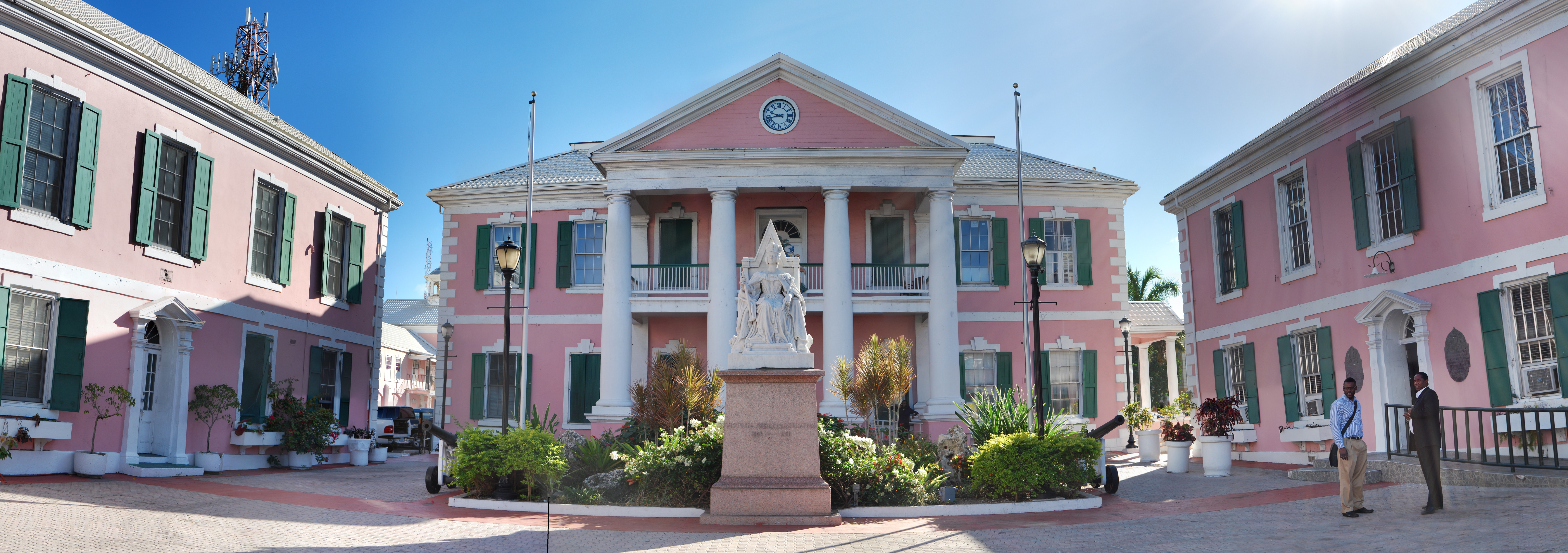
 A view of The Bahamian Parliament
Downtown is the hub for all activities in Nassau. Thousands of people visit daily, to shop, dine, sightsee and to enjoy the tropical climate of the city. While the busiest part of Downtown is the Bay Street thoroughfare and the Woodes Rogers Walk, located across the street from the port and parallel to Bay, the area actually extends for several blocks in each direction. It starts at West Bay, around the Junkanoo Beach area. A few hotels and restaurants are located on West Bay, most notably Compass Point, Holiday Inn, Quality Inn, and Chez Willie. The next landmark is the British Colonial Hotel, which marks the beginning of Bay Street proper. Pirates of Nassau Museum is just across from the British Colonial Hilton. The next few blocks of Bay Street are wall-to-wall boutiques, with a few restaurants and clubs interspersed throughout the retailers. Famous historical landmarks are also in the vicinity, including Vendue House and the Christ Church Cathedral. Although the tourist part of Downtown peters out after about seven blocks, smaller, more local stores are found all the way down Bay Street. At this point, Bay Street becomes East Bay.
Cable Beach
Cable Beach is recognised as the hotel district of Nassau. Five enormous hotels—two of which are all-inclusive—are located on this strip. The area is also known for its dining options, the Crystal Palace Casino, and the golden sands of Cable Beach itself. Most of the area's restaurants are located either in the hotels or across the street. BBQ Beach, Androsia and Capriccio are three of the best dining options in the Cable Beach area, each offering unique décor, a serene atmosphere, and distinctive cuisine. There is little to no nightlife. There is a bit of shopping, most of it located in the Wyndham.
Demographics
Historical populations Year Pop. ±% 1901 12,500 — 1931 19,800 +58.4% 1943 29,391 +48.4% 1953 46,125 +56.9% 1963 80,907 +75.4% 1970 101,503 +25.5% 1980 135,437 +33.4% 1990 172,196 +27.1% 2000 202,963 +17.9% 2010 248,948 +22.7% 2011 252,400 +1.4% Source: [5] Nassau has a population of 126,500 females and 121,800 males and is home to 59,707 households with an average family size of 4.15 according to the 2000 census.[6][7] Nassau's large population (at least in relation to the remainder of the Bahamas) is the result of waves of migration from the Family Islands to the capital. Consequently this has led to the decline in the population of the lesser developed islands and the rapid growth of Nassau.[citation needed]
Culture
Main article: Culture of the BahamasJunkanoo
 Junkanoo participant in costume during the 2006 Parade
The city's chief festival is Junkanoo, an energetic, colorful street parade of brightly costumed people dancing to the rhythmic accompaniment of cowbells, drums and whistles. The celebration occurs on December 26 and January 1, beginning in the early hours of the morning (1:00 a.m.) and ending around 10 a.m.
In popular culture
Nassau has featured as an important location in several movies, including the James Bond film Thunderball, and the Beatles film Help, both released in the 1960s. Nassau was again the location for the 1983 Bond film Never Say Never Again, (a remake of Thunderball) also starring Sean Connery, and it is the setting for part of the action in the 2006 Bond film Casino Royale starring Daniel Craig.
In 1981, it was used as a location for the ocean scene (in the film portrayed as being in Greece) in For Your Eyes Only, where Kristatos (Julian Glover) attempted to eliminate Bond (Roger Moore) and Melina Havelock (Carole Bouquet) by tying them to his boat and dragging them through coral and shark infested waters.[8]
Nassau is also heavily featured in the novel Tobin in Paradise by Stanley Morgan. The story is centered around the visit by the main character, Russ Tobin, to Nassau and Paradise Island, and the comedic events that ensue.
Nassau has also been the setting for several other recent movies including After the Sunset, Into the Blue and Flipper.
The capital hosted the games of the 2004 World's Strongest Man contest. Atlantis Paradise Island was the venue for the 2009 Miss Universe pageant.
Nassau is an unlock-able level in the 2010 Gameloft racing game Asphalt 6: Adrenaline.
In Pirates of the Caribbean: Curse of the Black Pearl, the character Elizabeth Swann says that Captain Jack Sparrow once "sacked Nassau Port without firing a shot".
Sister cities
Nassau has five sister cities world wide:
 Detroit, Michigan, USA[9]
- Winston-Salem, North Carolina, USA
 Acapulco, Mexico
 Shanghai, China
 Paraná, Argentina
See also
- List of Caribbean Cities and Towns by population
- Ardastra Gardens, Zoo and Conservation Centre
References
- ^ Klausmann, Ulrike; Meinzerin, Marion; Kuhn, Gabriel (1997). Women Pirates and the Politics of the Jolly Roger (1st ed.). C.P. 1258 Succ. Place du Parc Montreal, Quebec, Canada H2W2R3: Black Rose Books Ltd.. p. 192. ISBN 1-55164-058-9.
- ^ Marley, David (2005). Historic Cities of the Americas: An Illustrated Encyclopedia. ABC-CLIO. p. 6. ISBN 1576070271. http://books.google.co.uk/books?id=q1a4j2HNmjUC&pg=PA6&dq=Nassau+1695#v=onepage&q=Nassau%201695&f=false.
- ^ "Weather Information for Nassau". http://www.worldweather.org/025/c00097.htm.
- ^ "Climatological Information for Nassau, Bahamas" (1961-1990) - Hong Kong Observatory
- ^ historical demographical data of the administrative division
- ^ "PROJECTED MID-YEAR POPULATION BY AGE-GROUP AND SEX". bahamas.gov.bs. http://statistics.bahamas.gov.bs/download/031648600.pdf.
- ^ "Bahamas People and Population Statistics". thebahamasguide.com. http://www.thebahamasguide.com/facts/population.htm.
- ^ [1]
- ^ http://www.detroitmi.gov/DepartmentsandAgencies/SisterCitiesProgram/tabid/710/Default.aspx
External links
Coordinates: 25°03′36″N 77°20′42″W / 25.06°N 77.345°W
Categories:- Nassau, Bahamas
- Populated places in the Bahamas
- New Providence Island
- Capitals in North America
- Populated places established in the 17th century
- Port settlements in North America
- Piracy


Wikimedia Foundation. 2010.