- Clontarf, Queensland
-
Clontarf
Queensland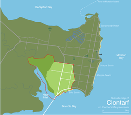
Population: 7,723 (2006 census)[1] Established: 1971 Postcode: 4019 Elevation: 12 m (39 ft) Area: 6.3 km² (2.4 sq mi) Location: - 25 km (16 mi) NNE of Brisbane CBD
- 3.9 km (2 mi) SW of Redcliffe CBD
LGA: Moreton Bay Region Region: South East Queensland State District: Redcliffe Federal Division: Petrie Suburbs around Clontarf: Rothwell Kippa-Ring Redcliffe Hays Inlet Clontarf Margate
Woody PointHays Inlet Bramble Bay Bramble Bay Clontarf is a residential and light industrial suburb of the Moreton Bay Region in the south-west of the Redcliffe peninsula, approximately 29 kilometres (18 mi) north-northeast of Brisbane, the state capital of Queensland, Australia.
Contents
Attractions and features
 The Hornibrook Bridge, looking towards the southern tip of Clontarf
Clontarf is connected to Brisbane City, across Bramble Bay, by the Houghton Highway which is a 2.7 km long causeway that provides access to the southern tip of Redcliffe City, greatly decreasing the travel time between Redcliffe and Brisbane. The Houghton Highway replaced the Hornibrook Bridge which is now used by pedestrians, cyclists and for recreational fishing.
Clontarf Beach and Bells Beach are two of the closest beaches to Brisbane City.
 Kites at Kitefest, an annual festival in Clontarf at Pelican Park
Pelican Park is known for its kite flying conditions, and a local industry has built around the sport. On weekends, many kites can be seen flying above Clontarf from the Hornibrook Bridge. During May, the Redcliffe Kite Club, based in Clontarf holds a two day kite event called Kitefest.
Industry
 Evening peak traffic flow into Clontarf
Clontarf's west hosts the largest industrial area in the Redcliffe area, and the area is a significant source of employment for the region. Many residents of Clontarf also commute to Brisbane daily for work. Most commuters travel by car, as there is no train line to Redcliffe.
Clontarf is host to two adjacent medium-sized shopping centres, on the southern tip of the suburb. Most retail commerce in the suburb revolves around small business however, and there are many stand alone corner stores and other small businesses still in existence.
Education
Several educational institutions are located within Clontarf: Clontarf Beach State High School, which opened in 1964 and has over 1240 enrolled students,[2] Clontarf Beach State School (1950) with approximately 350 students,[3] and a private school, Grace Lutheran Primary School (1971), with approximately 430 students.[4]
Public transport
Clontarf is served by several bus routes: Route 315, a limited-stops Monday-Friday service to Brisbane City; Route 693, an internal route within Redcliffe City, and Routes 690 and 695 to Sandgate railway station, an approximately 10-15 minute commute. All services are provided by Hornibrook Bus Lines.[5]
Gallery
-

'Pelicans' at Kitefest
-

Roosting pelican on the Houghton
-

Houghton Highway at sunset
-

Coles Express Clontarf
References
- ^ Australian Bureau of Statistics (25 October 2007). "Clontarf (Statistical Local Area)". 2006 Census QuickStats. http://www.censusdata.abs.gov.au/ABSNavigation/prenav/LocationSearch?collection=Census&period=2006&areacode=305456201&producttype=QuickStats&breadcrumb=PL&action=401. Retrieved 11 August 2007.
- ^ Queensland Government Department of Education, Training and the Arts. "Clontarf Beach State High School (SS) : Secondary Enrolments". Schools Directory. http://education.qld.gov.au/wcis/Enrolment/ListStateSecEnrolments.aspx?CtrCd=2091. Retrieved 2007-08-12.
- ^ Queensland Government Department of Education, Training and the Arts. "Clontarf Beach State School (SS) : Primary Enrolments". Schools Directory. http://education.qld.gov.au/wcis/Enrolment/ListStatePrimaryEnrolments.aspx?CtrCd=0162. Retrieved 2007-08-12.
- ^ Grace Lutheran Primary School (2007). "Our School". Archived from the original on 2007-08-16. http://web.archive.org/web/20070816235512/http://www.glps.qld.edu.au/our_school.htm. Retrieved 2007-09-08.
- ^ 310/N310/315 (PDF) (315) timetable, effective 3 September 2007; 690 (PDF), 693/696/697 (PDF) (693) and 695 (PDF) timetables, effective 20 June 2005. Retrieved on 8 September 2007.
External links
Coordinates: 27°14′47″S 153°04′58″E / 27.2463°S 153.0827°E
Categories:- Suburbs of Moreton Bay Region


Wikimedia Foundation. 2010.